The Columbia River Gorge is a canyon of the Columbia River in the Pacific Northwest of the United States. Up to 4,000 feet (1,200 m) deep, the canyon stretches for over eighty miles (130 km) as the river winds westward through the Cascade Range, forming the boundary between the state of Washington to the north and Oregon to the south. Extending roughly from the confluence of the Columbia with the Deschutes River in the east down to the eastern reaches of the Portland metropolitan area, the water gap furnishes the only navigable route through the Cascades and the only water connection between the Columbia Plateau and the Pacific Ocean. It is thus that the routes of Interstate 84, U.S. Route 30, Washington State Route 14, and railroad tracks on both sides run through the gorge.

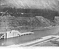
The Cascades Rapids were an area of rapids along North America's Columbia River, between the U.S. states of Washington and Oregon. Through a stretch approximately 150 yards (140 m) wide, the river dropped about 40 feet (12 m) in 2 miles (3.2 km). These rapids or cascades, along with the many cascades along the Columbia River Gorge in this area of Oregon and Washington, gave rise to the name for the surrounding mountains: the Cascade Range.

Celilo Falls was a tribal fishing area on the Columbia River, just east of the Cascade Mountains, on what is today the border between the U.S. states of Oregon and Washington. The name refers to a series of cascades and waterfalls on the river, as well as to the native settlements and trading villages that existed there in various configurations for 15,000 years. Celilo was the oldest continuously inhabited community on the North American continent until 1957, when the falls and nearby settlements were submerged by the construction of The Dalles Dam.

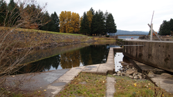
The Willamette Falls Locks are a lock system on the Willamette River in the U.S. state of Oregon. Opened in 1873 and closed since 2011, they allowed boat traffic on the Willamette to navigate beyond Willamette Falls and the T.W. Sullivan Dam. Since their closure in 2011 the locks are classified to be in a "non-operational status" and are expected to remain permanently closed.

The Oregon Trunk Rail Bridge or Celilo Bridge is a single-track railroad bridge opened in 1912 over the Columbia River in the Pacific Northwest of the United States. It consists of eight steel truss spans and several deck girder spans, and since 1957 it has included a vertical-lift section. The bridge was designed by engineer Ralph Modjeski and erected by the Missouri Valley Bridge & Iron Co., of Leavenworth, Kansas.

The Oregon Steam Navigation Company (O.S.N.) was an American company incorporated in 1860 in Washington with partners J. S. Ruckle, Henry Olmstead, and J. O. Van Bergen. It was incorporated in Washington because of a lack of corporate laws in Oregon, though it paid Oregon taxes.

Many steamboats operated on the Columbia River and its tributaries, in the Pacific Northwest region of North America, from about 1850 to 1981. Major tributaries of the Columbia that formed steamboat routes included the Willamette and Snake rivers. Navigation was impractical between the Snake River and the Canada–US border, due to several rapids, but steamboats also operated along the Wenatchee Reach of the Columbia, in northern Washington, and on the Arrow Lakes of southern British Columbia.
The Bailey Gatzert was a famous sternwheel steamboat that ran on the Columbia River and Puget Sound from the 1890s to the 1920s. This vessel was considered one of the finest of its time. It was named after Bailey Gatzert, an early businessman and mayor of Seattle, who was one of the closest friends and business associates of John Leary – the person who financed the ship.

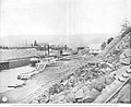
Celilo Canal was a canal connecting two points of the Columbia River between the states of Oregon and Washington, U.S. just east of The Dalles.

R. R. Thompson was a large sternwheel steamboat designed in the classic Columbia River style. She was named after Robert R. Thompson, one of the shareholders of the Oregon Steam Navigation Company, the firm that built the vessel.
The Colonel Wright was the first steamboat to operate on the Columbia River above The Dalles in the parts of the Oregon Country that later became the U.S. states of Oregon, Washington and Idaho. She was the first steamboat to run on the Snake River. She was named after Colonel George Wright, an army commander in the Indian Wars in the Oregon Country in the 1850s. She was generally called the Wright during her operating career.

The sidewheeler Idaho was a steamboat that ran on the Columbia River and Puget Sound from 1860 to 1898. There is some confusion as to the origins of the name; many historians have proposed it is the inspiration for the name of the State of Idaho. Considerable doubt has been cast on this due to the fact that it is unclear if the boat was named before or after the idea of 'Idaho' as a territory name was proposed. John Ruckel also allegedly stated he had named the boat after a Native American term meaning 'Gem of the Mountains' he got from a mining friend from what is now Colorado territory. This steamer should not be confused with the many other vessels of the same name, including the sternwheeler Idaho built in 1903 for service on Lake Coeur d'Alene and the steamship Idaho of the Pacific Coast Steamship Line which sank near Port Townsend, Washington.

Nez Perce Chief was a steamboat that operated on the upper Columbia River, in Washington, U.S., specifically the stretch of the river that began above the Celilo Falls. Her engines came from the Carrie Ladd, an important earlier sternwheeler. Nez Perce Chief also ran up the Snake River to Lewiston, Idaho, a distance of 141 miles from the mouth of the Snake River near Wallula, Wash. Terr.

Charles R. Spencer was a steamboat built in 1901 to run on the Willamette and Columbia rivers from Portland, to The Dalles, Oregon. This vessel was described as an "elegant passenger boat". After 1911 this vessel was rebuilt and renamed Monarch.

The Oregon Pony was the first steam locomotive to be built on the Pacific Coast and the first to be used in the Oregon Territory. The locomotive, a geared steam 5' gauge locomotive with 9"X18" cylinders and 34" drivers, was used in the early 1860s to portage steamboat passengers and goods past the Cascades Rapids, a dangerous stretch of the Columbia River now drowned by the Bonneville Dam. Steamboats provided transportation on the Columbia between Portland, Oregon and mining areas in Idaho and the Columbia Plateau. Portage was also necessary at other navigation obstructions, including Celilo Falls.

Sarah Dixon was a wooden sternwheel-driven steamboat operated by the Shaver Transportation Company on the Columbia and lower Willamette rivers from 1892 to 1926. Originally Sarah Dixon was built as a mixed use passenger and freight vessel, and was considered a prestige vessel for the time.

Harvest Queen was the name of two stern-wheel steamboat built and operated in Oregon. Both vessels were well known in their day and had reputations for speed, power, and efficiency.The first Harvest Queen, widely considered one of the finest steamers of its day, was constructed at Celilo, Oregon, which was then separated from the other portions of the navigable Columbia River by two stretches of difficult to pass rapids.

Regulator was a sternwheel-driven steamboat built in 1891 which operated on the Columbia River until 1906, when it was destroyed by explosion which killed two of its crew, while on the ways undergoing an overhaul at St. Johns, Oregon.

Telephone was a sternwheel-driven steamboat built in 1884 by Captain Uriah Bonsor "U.B." Scott for service on the Columbia River. Reputedly the fastest steamboat in the world in its time, Telephone served on the Columbia River and San Francisco Bay. Telephone was rebuilt at least twice. The first time was after a fire in 1887 which nearly destroyed the vessel. The reconstructed and much larger second vessel was sometimes referred to as Telephone No. 2. The third vessel, Telephone No. 3, built in 1903 and using components from the second steamer was larger but little used during its time on the Columbia river.

Relief was a stern-wheel steamboat that operated on the Columbia and Willamette rivers and their tributaries from 1906 to 1931. Relief had been originally built in 1902, on the Columbia at Blalock, Oregon, in Gilliam County, and launched and operated as Columbia, a much smaller vessel. Relief was used primarily as a freight carrier, first for about ten years in the Inland Empire region of Oregon and Washington, hauling wheat and fruit, and after that was operated on the lower Columbia river.