National Register of Historic Places listings in Southeast Portland, Oregon
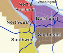
Last updated Locator map showing five of Portland's six quadrants. Click a quadrant to go to its National Register list. (South Portland listings are included on the Southwest Portland list.)
This list presents the full set of buildings, structures, objects, sites, or districts designated on the National Register of Historic Places in Southeast Portland, Oregon, and offers brief descriptive information about each of them. The National Register recognizes places of national, state, or local historic significance across the United States.[1] Out of over 90,000 National Register sites nationwide,[2]Oregon is home to over 2,000,[3] and over one-fourth of those are found partially or wholly in Portland. While these sites are widely spread across all six of Portland's quadrants, heavy concentrations are found in the Downtown and Southwest Hills neighborhoods of the Southwest quadrant, and the Northwest District neighborhood of the Northwest quadrant.
Only historic places within the municipal boundaries of Portland are shown in this list and its four companion lists for the other quadrants. Some sites beyond city limits will appear in other lists showing "Portland" as a general locality, but are excluded here. Although Portland's legal boundaries extend into Clackamas and Washington counties, all of the city's National Register sites lie within Multnomah County.
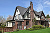
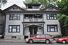
H. Russell Albee (1867–1950) was Mayor of Portland (1913–1917) during its complex transition to a new form of commission-based government. A. E. Doyle (1877–1928) designed this 1912 house for him, and it remains one of the finest and best-preserved Colonial Revival houses in Doyle's body of work. Albee lived here for the duration of his mayoral administration and until 1918.[7]
This Barbel-classdiesel-electricsubmarine, launched in 1959, was the last non-nuclear submarine to join the U.S. Navy and the last to be decommissioned. The Barbels' teardrop-shaped hulls were revolutionary for their time and became the standard for subsequent classes of submarine worldwide. Beginning in 1994, Blueback was converted into a museum ship.[8][9]
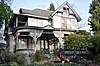
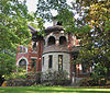
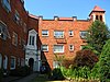
This 1888 Italianate structure is one of the few stately homes remaining from the late-19th century period when Mount Tabor was one of Portland's most prestigious neighborhoods. It was occupied by a series of residents prominent in business, including farmer, real estate investor, and banker William E. Brainard; stock broker and investment banker George W. Davis; and dentist and dental supplier John C. Welch.[10]
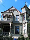
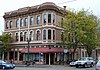
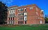
Built in 1891 by John Buckler for Charles K. Henry, who platted the neighborhood in 1890, this house is one of Portland's few remaining examples of 19th century brick residential construction. Prominent later residents included Grace Olivier Peck, who served in the Oregon House of Representatives for 22 years between 1948 and 1977.[11][12]
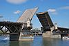
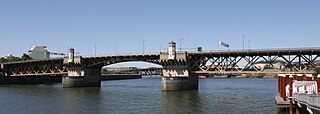
Opened in 1926 as a centerpiece of Portland's transportation system, the Burnside Bridge was embroiled in a public corruption scandal during its development. Part of a three-bridge package funded by a public bond issue, it was one of the final works in bridge engineer Gustav Lindenthal's impressive career.[lower-alpha 1] It is one of the country's heaviest bascule bridges, and the earliest to use a concrete deck on the lift span.[13]
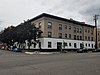
This 1911 library, designed by Portland architect A.E. Doyle and built with funding from the Carnegie Foundation, became one of the earliest public library branches outside downtown Portland. It has since been converted to an office building.[14]
Built starting in 1910, this is an exceptional case of a streetcar suburbplanned, developed, and marketed by a single entity. Its winding streets combined with radial thoroughfares make an unusually full expression of the ideals of the City Beautiful movement. The c.1700 houses in the district illustrate the popular trends in domestic architecture through the 1940s. Aimed at the middle and upper class market for single-family homes, Laurelhurst's exclusionary rules were accentuated by zoning codes and racially restrictive deed covenants.[16]
Pioneer cemetery formally established in 1855, the oldest interment dating to 1846.[17] It provides the final resting place of a broad cross-section of Portland society, from many of its most prominent citizens[18] to over 1,100 early Chinese American immigrants.[19]
Unmodified since its manufacture in 1938 and still fully functional, SP&S 700 represents the zenith of steam locomotive technology and practice at the end of the "Age of Steam". By 2006, it was the third-largest and second-most powerful steam locomotive remaining in the world.[21]
↑ The three bridges in the bond-funded package were the Burnside Bridge, Ross Island Bridge, and Sellwood Bridge (which has since been demolished and replaced). Lindenthal was the supervising engineer for the construction of all three bridges. He was responsible for the design of the Ross Island and Sellwood bridges, but for the Burnside Bridge he adapted a design by Ira G. Hedrick and Robert E. Kremers. Hedrick and Kremers were removed from the project due to the corruption scandal.
Related Research Articles
Multnomah Falls is a waterfall located on Multnomah Creek in the Columbia River Gorge, east of Troutdale, between Corbett and Dodson, Oregon, United States. The waterfall is accessible from the Historic Columbia River Highway and Interstate 84. Spanning two tiers on basalt cliffs, it is the tallest waterfall in the state of Oregon at 620 ft (189 m) in height. The Multnomah Creek Bridge, built in 1914, crosses below the falls, and is listed on the National Register of Historic Places.
The Burnside Bridge is a 1926-built bascule bridge that spans the Willamette River in Portland, Oregon, United States, carrying Burnside Street. It is the second bridge at the same site to carry that name. It was added to the National Register of Historic Places in November 2012.
The Sellwood Bridge is a deck arch bridge that spans the Willamette River in Portland, Oregon, in the United States. The current bridge opened in 2016 and replaced a 1925 span that had carried the same name. The original bridge was Portland's first fixed-span bridge and, being the only river crossing for miles in each direction, the busiest two-lane bridge in Oregon. The Sellwood Bridge links the Sellwood and Westmoreland neighborhoods of Portland on the east side with Oregon Route 43/Macadam Avenue on the west side. At its east end it leads to Tacoma Street. The bridge is owned and operated by Multnomah County. The original span of 1925 was a steel truss bridge, while its 2016 replacement is a deck-arch-type bridge.
This is a list of properties and historic districts in Oregon that are listed on the National Register of Historic Places. There are listings in all of Oregon's 36 counties.
The following list presents the full set of National Register of Historic Places listings in Multnomah County, Oregon. However, please see separate articles for listings in each of Portland's six quadrants.
The Springwater Corridor Trail is a bicycle and pedestrian rail trail in the Portland metropolitan area in Oregon, United States. It follows a former railway line from Boring through Gresham to Portland, where it ends south of the Eastbank Esplanade. Most of the corridor, about 21 miles (34 km) long, consists of paved, off-street trail, though about 1 mile (1.6 km) overlaps city streets in Portland's Sellwood neighborhood. A large segment roughly follows the course of Johnson Creek and crosses it on bridges many times. Much of the corridor was acquired by the City of Portland in 1990; remaining segments were acquired by Metro thereafter.
↑ Oregon Parks and Recreation Department, Oregon Historic Sites Database, retrieved August 6, 2015. Note that a simple count of National Register records in this database returns a slightly higher total than actual listings, due to duplicate records. A close reading of detailed query results is necessary to arrive at the precise count.
1 2 Numbers represent an alphabetical ordering by significant words. Various colorings, defined here, differentiate National Historic Landmarks and historic districts from other NRHP buildings, structures, sites or objects.
↑ The eight-digit number below each date is the number assigned to each location in the National Register Information System database, which can be viewed by clicking the number.
↑ Bauer, K. Jack; Roberts, Stephen S. (1991). Register of Ships of the U.S. Navy, 1775-1990: Major Combatants. Westport, CT: Greenwood Press. ISBN0-313-26202-0.
↑ Niles, Philip (2008). Beauty of the City: A.E. Doyle, Portland's Architect. Corvallis, OR: Oregon State University Press. pp.90–92. ISBN978-0-87071-298-2.
This page is based on this Wikipedia article Text is available under the CC BY-SA 4.0 license; additional terms may apply. Images, videos and audio are available under their respective licenses.