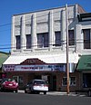
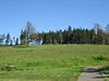
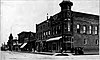
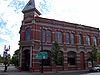
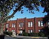
[5] Name on the Register Image Date listed [6] Location City or town Description 1 Beulah Methodist Episcopal Church Beulah Methodist Episcopal Church December 31, 2002 (# 02001638 242 North Main 44°51′59″N 123°25′49″W / 44.866389°N 123.430278°W / 44.866389; -123.430278 (Beulah Methodist Episcopal Church ) Falls City 2 Harrison Brunk House Harrison Brunk House May 6, 1975 (# 75001599 Brunks Corner and Oregon Route 22 44°56′01″N 123°08′48″W / 44.933611°N 123.146667°W / 44.933611; -123.146667 (Harrison Brunk House ) Brunks Corner 3 Burford-Stanley House Burford-Stanley House February 24, 2022 (# 100007458 342 Monmouth Ave. South 44°50′45″N 123°14′15″W / 44.8459°N 123.2375°W / 44.8459; -123.2375 (Burford-Stanley House ) Monmouth 4 James S. and Jennie M. Cooper House James S. and Jennie M. Cooper House February 22, 1988 (# 88000092 242 D Street [7] 44°51′01″N 123°11′12″W / 44.850414°N 123.186591°W / 44.850414; -123.186591 (James S. and Jennie M. Cooper House ) Independence 5 Joseph and Priscilla Craven House Joseph and Priscilla Craven House March 5, 1998 (# 98000210 858 E. Main St. 44°50′56″N 123°13′30″W / 44.848889°N 123.225°W / 44.848889; -123.225 (Joseph and Priscilla Craven House ) Monmouth 6 Dallas Cinema Dallas Cinema October 28, 2022 (# 100008328 166 SE Mill St. 44°55′18″N 123°18′57″W / 44.9216°N 123.3158°W / 44.9216; -123.3158 (Dallas Cinema ) Dallas 7 Dallas Tannery Dallas Tannery November 6, 1980 (# 80003379 505 SW Levens St. 44°55′32″N 123°19′09″W / 44.925556°N 123.319167°W / 44.925556; -123.319167 (Dallas Tannery ) Dallas 8 Dr. John E. and Mary D. Davidson House Dr. John E. and Mary D. Davidson House February 28, 1985 (# 85000371 887 Monmouth St. 44°51′03″N 123°11′46″W / 44.850879°N 123.196247°W / 44.850879; -123.196247 (Dr. John E. and Mary D. Davidson House ) Independence 9 Walter J. Domes House Walter J. Domes House March 9, 1990 (# 90000373 8240 Pacific Hwy. W. 45°03′14″N 123°12′24″W / 45.053942°N 123.206629°W / 45.053942; -123.206629 (Walter J. Domes House ) Rickreall 10 Kersey C. Eldridge House Kersey C. Eldridge House July 14, 1988 (# 88001040 675 Monmouth St. 44°51′03″N 123°11′36″W / 44.850878°N 123.193227°W / 44.850878; -123.193227 (Kersey C. Eldridge House ) Independence 11 Fort Yamhill Site Fort Yamhill Site July 27, 1971 (# 71000681 32130–37008 3 Rivers Highway [8] 45°04′08″N 123°34′12″W / 45.068952°N 123.570056°W / 45.068952; -123.570056 (Fort Yamhill Site ) Grand Ronde [8] 12 Grand Ronde Rail Depot Grand Ronde Rail Depot December 26, 2012 (# 12001092 8615 Grand Ronde Road 45°03′36″N 123°36′39″W / 45.060016°N 123.610735°W / 45.060016; -123.610735 (Grand Ronde Rail Depot ) Grand Ronde 13 Graves–Fisher–Strong House Graves–Fisher–Strong House June 20, 1985 (# 85001336 391 E. Jackson St. 44°50′59″N 123°13′51″W / 44.849722°N 123.230833°W / 44.849722; -123.230833 (Graves–Fisher–Strong House ) Monmouth 14 Jesse and Julia Harritt House Jesse and Julia Harritt House April 2, 1999 (# 99000356 2280 Wallace Rd. NW 44°58′00″N 123°03′28″W / 44.966713°N 123.057718°W / 44.966713; -123.057718 (Jesse and Julia Harritt House ) Salem 15 Sarah Helmick State Park Sarah Helmick State Park May 9, 2022 (# 100007759 10485 Helmick Rd. 44°46′54″N 123°14′16″W / 44.7818°N 123.2379°W / 44.7818; -123.2379 (Sarah Helmick State Park ) Monmouth vicinity 16 John W. Howell House John W. Howell House September 10, 1987 (# 87001536 212 N. Knox St. 44°50′59″N 123°13′59″W / 44.849722°N 123.233056°W / 44.849722; -123.233056 (John W. Howell House ) Monmouth 17 Independence Historic District Independence Historic District March 1, 1989 (# 89000048 Roughly bounded by Butler, Main, G, and Ninth Sts. 44°51′02″N 123°11′23″W / 44.850556°N 123.189722°W / 44.850556; -123.189722 (Independence Historic District ) Independence 18 Independence National Bank Independence National Bank November 6, 1986 (# 86003182 302 S. Main St. 44°51′04″N 123°11′05″W / 44.851023°N 123.184837°W / 44.851023; -123.184837 (Independence National Bank ) Independence 19 Parker School Parker School June 16, 1989 (# 89000514 8900 Parker Rd. 44°46′47″N 123°12′38″W / 44.779722°N 123.210556°W / 44.779722; -123.210556 (Parker School ) Independence 20 John Phillips House John Phillips House March 15, 1976 (# 76001588 Northwest of Salem on Spring Valley Rd. 45°01′40″N 123°07′29″W / 45.027778°N 123.124722°W / 45.027778; -123.124722 (John Phillips House ) Salem 21 Polk County Bank Polk County Bank November 6, 1986 (# 86003179 295 E. Main St. 44°50′54″N 123°13′55″W / 44.848333°N 123.231944°W / 44.848333; -123.231944 (Polk County Bank ) Monmouth 22 Riley–Cutler House Riley–Cutler House April 3, 1980 (# 80003380 11510 Pedee Creek Rd. 44°46′06″N 123°26′44″W / 44.768396°N 123.445507°W / 44.768396; -123.445507 (Riley–Cutler House ) Monmouth vicinity 23 Ritner Creek Bridge Ritner Creek Bridge November 29, 1979 (# 79002147 South of Pedee 44°43′44″N 123°26′28″W / 44.728889°N 123.441111°W / 44.728889; -123.441111 (Ritner Creek Bridge ) Monmouth 24 Saint Patrick's Roman Catholic Church Saint Patrick's Roman Catholic Church February 5, 1987 (# 87000040 330 Monmouth St. 44°51′05″N 123°11′16″W / 44.851345°N 123.187841°W / 44.851345; -123.187841 (Saint Patrick's Roman Catholic Church ) Independence 25 Edward W. St. Pierre House Edward W. St. Pierre House February 21, 1989 (# 89000050 2425 Eola Dr. 44°56′40″N 123°04′55″W / 44.944577°N 123.081946°W / 44.944577; -123.081946 (Edward W. St. Pierre House ) Salem 26 Eleanor Sherman House Eleanor Sherman House February 21, 1989 (# 89000054 175 N. Craven St. 44°50′58″N 123°13′31″W / 44.849444°N 123.225278°W / 44.849444; -123.225278 (Eleanor Sherman House ) Monmouth 27 Spring Valley Presbyterian Church Spring Valley Presbyterian Church May 15, 1974 (# 74001717 Southeast of McCoy 45°00′46″N 123°07′43″W / 45.012745°N 123.128533°W / 45.012745; -123.128533 (Spring Valley Presbyterian Church ) Salem vicinity 28 Spring Valley School Spring Valley School February 9, 2018 (# 100002097 8295 Spring Valley Road NW 45°03′14″N 123°05′55″W / 45.053973°N 123.098711°W / 45.053973; -123.098711 (Spring Valley School ) Zena 29 Union Street Railroad Bridge and Trestle Union Street Railroad Bridge and Trestle January 11, 2006 (# 05001520 Junction of Union and Water Streets, NE (See also Marion County .) 44°56′50″N 123°02′31″W / 44.94712°N 123.042°W / 44.94712; -123.042 (Union Street Railroad Bridge and Trestle ) Salem 30 George A. Wells Jr. House George A. Wells Jr. House December 22, 1981 (# 81000521 10635 Buena Vista Rd. 44°46′47″N 123°09′05″W / 44.779722°N 123.151389°W / 44.779722; -123.151389 (George A. Wells Jr. House ) Independence 31 Old West Salem City Hall Old West Salem City Hall June 1, 1990 (# 90000841 1320 Edgewater St. NW 44°56′23″N 123°03′33″W / 44.939722°N 123.059167°W / 44.939722; -123.059167 (Old West Salem City Hall ) Salem 32 J. A. Wheeler House J. A. Wheeler House November 6, 1986 (# 86003177 386 Monmouth St. 44°51′05″N 123°11′19″W / 44.851368°N 123.188693°W / 44.851368; -123.188693 (J. A. Wheeler House ) Independence 33 A. K. Wilson Building A. K. Wilson Building July 31, 1998 (# 98000952 887 Main St. 44°55′14″N 123°19′01″W / 44.920690°N 123.317062°W / 44.920690; -123.317062 (A. K. Wilson Building ) Dallas