Brunks Corner, Oregon

Last updated

Harrison Brunk House at Brunks Corner BrunksCorner.JPG
Harrison Brunk House at Brunks Corner

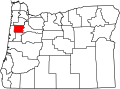
Brunks Corner is an unincorporated community in Polk County, Oregon, United States, at the junction of Oregon Route 22 and Oak Grove Road, near the terminus of Oregon Route 51. [1]

The 1861 Harrison Brunk House at Brunks Corner was built by an early Oregon pioneer and is now a historic house museum run by the Polk County Historical Society. [2] [3] The site was designated a Century Farm in 1959. [3] The house was listed on the National Register of Historic Places in 1975. [4]

Related Research Articles

<span class="mw-page-title-main">Polk County, Oregon</span> County in Oregon, United States

Polk County is one of the 36 counties in the U.S. state of Oregon. As of the 2020 census, the population was 87,433. The county seat is Dallas. The county is named for James Knox Polk, the 11th president of the United States.

<span class="mw-page-title-main">Polk County, Missouri</span> County in Missouri, United States

Polk County is a county located in the southwestern portion of the U.S. state of Missouri. As of the 2020 census, the population was 31,519. Its county seat is Bolivar. The county was organized January 5, 1835, and named for Ezekiel Polk.

<span class="mw-page-title-main">Willamina, Oregon</span> City in Oregon, United States

Willamina is a city in Polk and Yamhill Counties in the U.S. state of Oregon. The population was 2,239 at the 2020 census.

<span class="mw-page-title-main">Valsetz, Oregon</span>

Valsetz was an unincorporated community and timber company town in Polk County, Oregon, United States, west of Falls City in the Central Oregon Coast Range. It no longer exists.

<span class="mw-page-title-main">Ellendale, Oregon</span>

Ellendale is a ghost town in Polk County, Oregon, United States, about two and a half miles west of Dallas. It was the first settlement in present-day Polk County by non-Kalapuyans. The community's name changed over the years, with the first post office in Polk County being opened in this locality as "O'Neils Mills" in 1850. The post office was renamed "Nesmiths" in 1850 and discontinued in 1852. The community was eventually renamed Ellendale.

<span class="mw-page-title-main">Washington Township, Owen County, Indiana</span> Township in Indiana, United States

Washington Township is one of thirteen townships in Owen County, Indiana, United States. As of the 2010 census, its population was 6,164 and it contained 2,755 housing units.

Buena Vista is an unincorporated community in Polk County, Oregon, United States. It is located on the Willamette River, and is the western landing for the Buena Vista Ferry. It is approximately 7 miles (11 km) south-southeast of Independence.

<span class="mw-page-title-main">John Phillips House</span> Historic house in Oregon, United States

John Phillips House is a historic 1853 vernacular Greek Revival house in the Spring Valley area of Polk County, Oregon, United States. It was built for pioneer John Phillips, who came to Oregon via the Oregon Trail in 1845. He finished his journey to Oregon on the Meek Cutoff as part of Stephen Meek's "lost wagon train".

Alder is an unincorporated community in Benton County, Oregon, United States. Alder lies near U.S. Route 20 southeast of Blodgett on the Marys River in the Central Oregon Coast Range. The post office serving Alder was named Hipp.

Salt Creek is an unincorporated historic community in Polk County, Oregon, United States on Oregon Route 22 about six miles northwest of Dallas. As an early European American settlement of the Oregon Country, the cemetery at Salt Creek has graves dating back to 1847. Salt Creek, a tributary of the South Yamhill River, was named by early settlers for the salt licks found on its banks. The Salt Creek post office, named after the creek, was established in 1852 and closed in 1903. James B. Riggs, who arrived in Oregon via the Oregon Trail and the Meek Cutoff in 1845, was the first postmaster. Riggs previously been the first postmaster of Yoncalla, followed by Jesse Applegate.

<span class="mw-page-title-main">Dolph, Oregon</span> Unincorporated community in the state of Oregon, United States

Dolph is an unincorporated community in Tillamook County, Oregon, United States, near the Yamhill County line. It lies at the junction of Oregon Route 22 and Oregon Route 130 between Grande Ronde and Hebo, on the Little Nestucca River. It is within the Siuslaw National Forest in the Northern Oregon Coast Range.

Shaw is an unincorporated community in Marion County, Oregon, United States, on Oregon Route 214.

<span class="mw-page-title-main">Milo, Oregon</span> Unincorporated community in the state of Oregon, United States

Milo is an unincorporated community in Douglas County, Oregon, United States, about 17 miles (27 km) east of Canyonville on the South Umpqua River.

Tiernan is an unincorporated community in Lane County, Oregon, United States. It is about five miles west of Mapleton on Oregon Route 126 near the Siuslaw River and within the Siuslaw National Forest.

Burnt Woods is an unincorporated community in Lincoln County, Oregon, United States. It is located about 16 miles (26 km) west of Philomath on U.S. Route 20 in the Central Oregon Coast Range near the Tumtum River.

Airlie is an unincorporated community in Polk County, Oregon, United States.

Black Rock is an unincorporated community and former logging camp in Polk County, Oregon, United States. It is located about three miles west of Falls City, in the Central Oregon Coast Range on the Little Luckiamute River.

Suver is an unincorporated community in Polk County, Oregon, United States. It is located about 10 miles north of Corvallis and about 8 miles south of Monmouth, 1 mile east of Oregon Route 99W.

Derry is an unincorporated locale in Polk County, Oregon, United States. It is located about 10 miles west of Salem and one mile east of Rickreall.

<span class="mw-page-title-main">Coryell Pass</span>

Coryell Pass is a gap located near Eugene in Lane County, Oregon, United States, near the confluence of the Coast Fork and Middle Fork of the Willamette River. The gap is formed by the river between Eugene's South Hills and Springfield's Quarry Butte. The pass is commemorated by a brass marker located on Franklin Boulevard, on what was formerly the route of Pacific Highway. The marker, which was placed by the Daughters of the American Revolution (D.A.R.), reads "Coryell Pass, Oregon Trail, 1846, Erected by Oregon Lewis and Clark Chapter D.A.R., 1917". The pass was on the southern route of the Oregon Trail blazed by Jesse Applegate and known as the Applegate Trail.

References

  1. "Brunks Corner". Geographic Names Information System . United States Geological Survey, United States Department of the Interior. November 28, 1980. Retrieved January 12, 2010.
  2. Friedman, Ralph (1990). In Search of Western Oregon (2nd ed.). Caldwell, Idaho: The Caxton Printers, Ltd. p. 484. ISBN   0-87004-332-3.
  3. 1 2 "About Us". Polk County Historical Society. Retrieved January 12, 2010.
  4. "Oregon National Register List" (PDF). Oregon Parks and Recreation Department. October 19, 2009. Archived from the original (PDF) on June 9, 2011. Retrieved January 12, 2010.

44°55′58″N123°08′51″W / 44.932897°N 123.147599°W / 44.932897; -123.147599