The Oregon Parks and Recreation Department (OPRD),[1] officially known (in state law) as the State Parks and Recreation Department,[2] is the government agency of the U.S. state of Oregon which operates its system of state parks. In addition, it has programs to protect and provide public access to natural and historic resources within the state, including the State Historic Preservation Office, Oregon Heritage Commission, Oregon Commission on Historic Cemeteries, recreation trails, the Ocean Shores Recreation Area, scenic waterways and the Willamette River Greenway. The department's chief sources of funding are the Oregon Lottery, state park user fees. and recreation vehicle license fees. The department also manages the system of rest areas along the highways and freeways within the state. In 2006 the department was delegated responsibility for managing the Oregon State Fair.[3]
The department was created in 1921[4] as a branch of the Oregon Highway Department (predecessor to the present-day Oregon Department of Transportation). The 1989 Oregon Legislative Assembly transferred authority to a newly created department under its current name effective January 1, 1990.
In the 2019 fiscal year, Oregon state parks attracted 55 million visitors, a 1.3percent increase from the previous fiscal year.[5] For the 2010 fiscal year, Oregon ranked first among U.S. states in state park capacity utilization rate, indicating that Oregon's state parks were the most overused.[6] As of 2012, 7.5 percent of lottery revenues in Oregon were dedicated to state and local parks, leading to new park acquisitions and a reduced backlog of maintenance at existing parks. Nevertheless, Oregon ranked 30th in the nation in state park acreage per 1,000 people. At the same time, it ranked second nationally for the number of park visitors per acre, indicating that the state’s limited area of parks are intensively used.[7]
The National Park Service (NPS) is an agency of the federal government of the United States that manages all national parks, many national monuments, and other conservation and historical properties with various title designations. The United States Congress created the agency on August 25, 1916 through the National Park Service Organic Act.
Multnomah Falls is a waterfall located on Multnomah Creek in the Columbia River Gorge, east of Troutdale, between Corbett and Dodson, Oregon, United States. The waterfall is accessible from the Historic Columbia River Highway and Interstate 84. Spanning two tiers on basalt cliffs, it is the tallest waterfall in the state of Oregon at 620 ft (189 m) in height.
The Historic Columbia River Highway is an approximately 75-mile-long (121 km) scenic highway in the U.S. state of Oregon between Troutdale and The Dalles, built through the Columbia River Gorge between 1913 and 1922. As the first planned scenic roadway in the United States, it has been recognized in numerous ways, including a listing on the National Register of Historic Places as a National Historic Landmark, designation as a National Historic Civil Engineering Landmark by the American Society of Civil Engineers, and considered a "destination unto itself" as an All-American Road by the U.S. Secretary of Transportation. The historic roadway was bypassed by the present Columbia River Highway No. 2 from the 1930s to the 1950s, leaving behind the old two-lane road. The road is now mostly owned and maintained by the state through the Oregon Department of Transportation as the Historic Columbia River Highway No. 100 or the Oregon Parks and Recreation Department as the Historic Columbia River Highway State Trail.
A Pure Michigan Byway is the designation for a segment of the State Trunkline Highway System in the US state of Michigan that is a "scenic, recreational, or historic route that is representative of Michigan's natural and cultural heritage." The designation was created with the name Michigan Heritage Route by the state legislature on June 22, 1993, and since then six historic, seven recreational and seven scenic byways have been designated by the Michigan Department of Transportation (MDOT), and another two have been proposed. These byways have been designated in both the Upper and Lower peninsulas of the state. The current name was adopted on December 30, 2014, and it references the Pure Michigan tourism marketing campaign.
The New York State Office of Parks, Recreation and Historic Preservation (NYS OPRHP) is a state agency within the New York State Executive Department charged with the operation of state parks and historic sites within the U.S. state of New York. As of 2014, the NYS OPRHP manages nearly 335,000 acres of public lands and facilities, including 180 state parks and 35 historic sites, that are visited by over 62 million visitors each year.
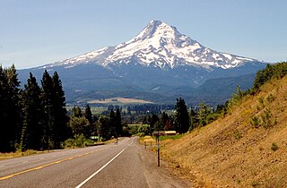
The Mount Hood Highway No. 26 is the Oregon Department of Transportation's designation for a 96.74-mile-long (155.69 km) highway from Portland east around the south side of Mount Hood and north via Bennett Pass to Hood River. It is marked as U.S. Route 26 from Portland to near Mount Hood and Oregon Route 35 the rest of the way to Hood River.
The OC&E Woods Line State Trail is a rail trail in Klamath and Lake counties in the U.S. state of Oregon. It is Oregon's longest state park. The trail follows the old OC&E and Weyerhaeuser railroads from Klamath Falls to Thompson Reservoir. Along its 105-mile (169 km) length it passes through the communities of Olene, Sprague River, Dairy, Beatty, and Bly.
The Michigan Department of Natural Resources (DNR) is the agency of the state of Michigan charged with maintaining natural resources such as state parks, state forests, and recreation areas. It is governed by a director appointed by the Governor and accepted by the Natural Resources Commission. Currently the Director is Daniel Eichinger. The DNR has about 1,400 permanent employees, and over 1,600 seasonal employees.
Ainsworth State Park is a state park in eastern Multnomah County, Oregon, near Cascade Locks. It is located in the Columbia River Gorge, adjacent to the Historic Columbia River Highway. The park administered by the Oregon Parks and Recreation Department, offers a seasonal, full-service campground, access to Gorge hiking trails beyond park boundaries, and a day-use area.
Tumalo State Park is a well-developed state park in Deschutes County, Oregon, United States. Established in 1954, the park is located northwest of the city of Bend and along the Deschutes River at a site home to many bird species. The park is popular for picnics, swimming, fishing, hiking, and camping, and is open year-round.
Chandler State Wayside is a state park in south-central Oregon in the United States. It is named in honor of Solomon and Hattie Chandler, who donated the land for the park. The park covers 85 acres (34 ha) of pine forest along a creek. The park provides restrooms and other basic facilities to accommodate the traveling public. Chandler State Wayside is administered by the Oregon Parks and Recreation Department.
Sheridan State Scenic Corridor is a state park in the Columbia River Gorge, west of Cascade Locks, Oregon. The 11-acre (4.5 ha) property, containing an old-growth forest, is located on the south side of Interstate 84 at approximately milepoint 42.5, and was not accessible by motor vehicle since I-84 was built in 1960. However, with the opening of the Eagle Creek-Cascade Locks segment of the Historic Columbia River Highway State Trail in 1998, it has become easily accessible by foot or bicycle. The park is on a triangular lot, completely surrounded by I-84 and the Mount Hood National Forest.
Samuel H. Boardman State Scenic Corridor is a linear state park in southwestern Oregon, in the United States. It is 12 miles (19 km) long and thickly forested along steep and rugged coastline with a few small sand beaches. It is named in honor of Samuel H. Boardman, the first Oregon Parks superintendent.
Booth State Scenic Corridor is a state park in the U.S. state of Oregon, administered by the Oregon Parks and Recreation Department.
Cline Falls State Scenic Viewpoint is a state park near Redmond, Oregon, United States. It is located on the Deschutes River. The park covers 9 acres (36,000 m2). It is administered by the Oregon Parks and Recreation Department.
Driftwood Beach State Recreation Site is a state park administered by the Oregon Parks and Recreation Department in the U.S. state of Oregon. Located 3 miles (5 km) north of Waldport along the Pacific Ocean, the park offers beach access, picnicking, and fishing in a setting of shore pines and sand. It is fee-free and open year-round.
John B. Yeon State Scenic Corridor is a state park in the U.S. state of Oregon, administered by the Oregon Parks and Recreation Department. It is located about 35 miles east of Portland in the Columbia Gorge. It is named in honor of John B. Yeon, one of the principle financiers of the Historic Columbia River Highway U.S. Route 30 which was constructed between 1913 and 1922. Located in the Columbia River Gorge National Scenic Area, the park features hiking trails that access some of the nearby waterfalls, including Elowah Falls.
Elliott Corbett Memorial State Recreation Site is a state park along the south shore of Blue Lake Crater in Jefferson County, Oregon, United States. The park is named in honor of Elliott R. Corbett II, who was killed while serving in the United States Army during World War II. It includes 63 acres (25 ha) of wilderness land with very few park facilities. Corbett State Park is administered by the Oregon Parks and Recreation Department.
Redmond–Bend Juniper State Scenic Corridor is a collection of ten unimproved land parcels administered for the Oregon Parks and Recreation Department. The parcels are located along U.S. Route 97 between Bend and Redmond, Oregon, United States. It is named for the large western juniper trees found on the parcels. The scenic corridor is completely undeveloped with no trails or park facilities of any kind.
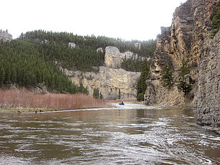
Smith River State Recreational Waterway, popularly known as the Smith River State Park, is a protected river corridor and "virtual park" owned and operated by the state of Montana in the United States. The site is not officially a state park, but rather a State Recreational Waterway and managed River Corridor. The park consists of the state-owned Smith River; a Montana Department of Fish, Wildlife and Parks (FWP) put-in access point, Camp Baker; 27 FWP-owned and -leased boat camps on the shore of the river; and the FWP-owned Eden Bridge take-out point. Little of the area is owned by FWP. Much of the surrounding shoreline is owned by the United States Forest Service, United States Bureau of Land Management, and private owners. Through management agreements with other government agencies and private landowners, FWP manages the 58.9-mile (94.8 km) Smith River Corridor as a "virtual state park". The Smith River is the only river in the state of Montana where a permit is required to boat or float on the river.
This page is based on this Wikipedia article Text is available under the CC BY-SA 4.0 license; additional terms may apply. Images, videos and audio are available under their respective licenses.