
Florence is a coastal city in Lane County, in the U.S. state of Oregon. It lies at the mouth of the Siuslaw River on the Pacific Ocean and about midway between Newport and Coos Bay along U.S. Route 101. As of the 2020 census, the city had a total population of 8,921.

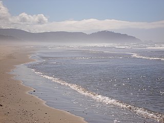
The Oregon Coast is a coastal region of the U.S. state of Oregon. It is bordered by the Pacific Ocean to its west and the Oregon Coast Range to the east, and stretches approximately 362 miles (583 km) from the California state border in the south to the Columbia River in the north. The region is not a specific geological, environmental, or political entity, and includes the Columbia River Estuary.

Fort Niagara State Park is located in the Town of Porter in Niagara County, New York, United States. Historic Fort Niagara is located within the park. The 504-acre (2.04 km2) park is northwest of Youngstown near the northern terminus of the Niagara Scenic Parkway and is in the Niagara Falls National Heritage Area.

Humbug Mountain is one of the highest mountains in the U.S. state of Oregon to rise directly from the Pacific Ocean. It lies on the state's southern coast, about 6 miles (10 km) south of Port Orford and 21 miles (34 km) north of Gold Beach. The mountain is completely within Humbug Mountain State Park, and U.S. Route 101 passes by its northern base. Its slopes feature an old-growth temperate rainforest. Two trails run from the state park campground to the mountain's summit, one 1.5 miles (2.4 km) long, the other 2 miles (3.2 km) long. Both are part of the much longer Oregon Coast Trail. The area is popular with hikers, campers, cyclists, and whale watchers although biking and camping on the mountain itself are prohibited.

Cape Blanco is a prominent headland on the Pacific Ocean coast of southwestern Oregon in the United States, forming the westernmost point in the state. Cape Blanco extends further west than any point of land in the contiguous United States except portions of the Olympic Peninsula in Washington, including Cape Alava, the true westernmost point. The cape is part of Cape Blanco State Park and is the location of the Cape Blanco Light, first lit in 1870.

The Oregon Coast Trail (OCT) is a long-distance hiking route along the Pacific coast of the U.S. state of Oregon in the United States. It follows the coast of Oregon from the mouth of the Columbia River to the California border south of Brookings.

The Lewis and Clark National Historical Park, located in the vicinity of the mouth of the Columbia River, commemorates the Lewis and Clark Expedition. Administration of the park, which includes both federal and state lands, is a cooperative effort of the National Park Service and the states of Oregon and Washington. The National Historical Park was dedicated on November 12, 2004.

The West Coast Trail, originally called the Dominion Lifesaving Trail, is a 75 km (47 mi) backpacking trail following the southwestern edge of Vancouver Island in British Columbia, Canada. It was built in 1907 to facilitate the rescue of shipwrecked survivors along the coast, part of the treacherous Graveyard of the Pacific. It is now part of the Pacific Rim National Park and is often rated by hiking guides as one of the world's top hiking trails.

Cascade Head is a headland and 270-acre (110 ha) UNESCO biosphere reserve and United States Forest Service Experimental Forest. It is situated 85 miles (137 km) southwest of Portland, Oregon on the Oregon Coast between Lincoln City and Neskowin. Cascade Head Preserve is a Nature Conservancy Selected Site.

The Columbia River Maritime Museum is a museum of maritime history in the northwest United States, located about ten miles (16 km) southeast of the mouth of the Columbia River in Astoria, Oregon.
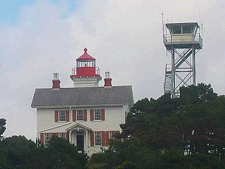
The Yaquina Bay Light is a lighthouse that was built in 1871, soon after the founding of the city of Newport, Oregon, in the United States. It is located on the north side of Yaquina Bay. In 1871–1874, it was the busiest and most populated of the many coastal ports between Washington and California.

Point Bonita Lighthouse is a lighthouse located at Point Bonita at the San Francisco Bay entrance in the Marin Headlands near Sausalito, California. Point Bonita was the last manned lighthouse on the California coast. It was added to the National Register of Historic Places in 1991.
Cape Meares National Wildlife Refuge is a National Wildlife Refuge of the Oregon Coast. It is one of six National Wildlife Refuges in the Oregon Coast National Wildlife Refuge Complex. Located on Cape Meares, the refuge was established in 1938 to protect a remnant of coastal old-growth forest and the surrounding habitat used by breeding seabirds. The area provides a home for a threatened bird species, the marbled murrelets. Peregrine falcons, once at the brink of extinction, have nested here since 1987. The refuge, with the exception of the Oregon Coast Trail, was designated a Research Natural Area in 1987.

The Mary D. Hume was a steamer built at Gold Beach, Oregon in 1881, by R. D. Hume, a pioneer and early businessman in that area. Gold Beach was then called Ellensburg. The Hume had a long career, first hauling goods between Oregon and San Francisco, then as a whaler in Alaska, as a service vessel in the Alaskan cannery trade, then as a tugboat. She was retired in 1977 and returned to Gold Beach. In 1985 she sank in the Rogue River and has remained there ever since as a derelict vessel on the shoreline. The Hume is listed on the National Register of Historic Places.

Cape Perpetua is a large forested headland projecting into the Pacific Ocean on the central Oregon Coast in Lincoln County, Oregon. The land is managed by the United States Forest Service as part of the Siuslaw National Forest.

Devils Punch Bowl State Natural Area is a state day use park on the central Oregon Coast in the United States. It is centered on a large bowl naturally carved in a rock headland which is partially open to the Pacific Ocean. Waves enter the bowl and often violently churn, swirl, and foam. Outside the bowl, ocean conditions are attractive to surfers near a large offshore rock pinnacle named Gull Rock, located about 1⁄2 mile (800 m) west-northwest of Devils Punch Bowl, which funnels and concentrates waves easily seen from the park. There are at least seventeen large rocks, part of Oregon Islands National Wildlife Refuge, which provide interesting wave viewing, and attract and provide a home for wildlife.
Humbug Mountain State Park is a state park located on the Oregon coast. It is administered by the Oregon Parks and Recreation Department. The park can be accessed via the US Route 101, 6 miles (10 km) south of Port Orford, and 28 miles (45 km) north of Gold Beach. It covers 1,842 acres (7.45 km2) of land around 1,759-foot (536 m) Humbug Mountain, one of the tallest headlands on the Oregon coast.
Rocky Creek State Scenic Viewpoint is a state park in Lincoln County in northwestern Oregon, United States. Administered by the Oregon Parks and Recreation Department, the 59-acre (24 ha) park lies along a bluff between Whale Cove and Rocky Creek. The park extends south along the Otter Crest Loop Road to the Rocky Creek Bridge.

The Coast Guard Museum Northwest is dedicated to preserving the heritage of the United States Coast Guard in the Pacific Northwest. The museum is located on the property of Coast Guard Station Seattle on the Elliott Bay waterfront south of Downtown, Seattle, Washington. It covers the full range of Coast Guard roles, ranging from protecting shores, lives and property to lighthouses and lightships, from life-saving stations to rescue boats, from buoy tenders to icebreakers and weather ships and from modern aircraft to patrol boats and cutters. The museum admittance is free of charge.

This is a list of United States Coast Guard historical and heritage sites that are open to the public. This list includes National Historic Landmarks (NHL), the National Register of Historic Places (NRHP), cutters, museums, monuments, memorials and more. It includes only NHL Lighthouses. There are many more resources dedicated to lighthouses, this list attempts to collect everything else in one list. The United States Lighthouse Society, Lighthouse Friends and the many Wikipedia pages dedicated lighthouses are a few of the many excellent resources for those interested in lighthouses. This list captures the most important historical features, that is the NHL and the often overlooked U.S. Coast Guard sites.


