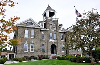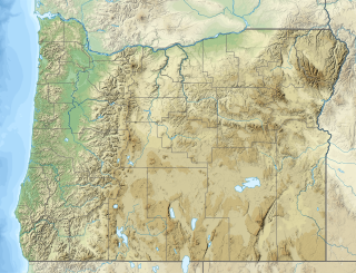
Wallowa County is one of the 36 counties in the U.S. state of Oregon. As of the 2010 census, the population was 7,008, making it Oregon's fourth-least populous county. Its county seat is Enterprise. According to Oregon Geographic Names, the origins of the county's name are uncertain, with the most likely explanation being it is derived from the Nez Perce term for a structure of stakes used in fishing. An alternative explanation is that Wallowa is derived from a Nez Perce word for "winding water". The journals of Lewis and Clark Expedition record the name of the Wallowa River as Wil-le-wah.

The Blue Mountains are a mountain range in the northwestern United States, located largely in northeastern Oregon and stretching into extreme southeastern Washington. The range has an area of about 15,000 square miles (38,850 km2), stretching east and southeast of Pendleton, Oregon, to the Snake River along the Oregon–Idaho border.

The Grande Ronde River is a tributary of the Snake River, 182 miles (293 km) long, in northeastern Oregon and southeastern Washington in the United States. It drains an area southeast of the Blue Mountains and northwest of the Wallowa Mountains, on the Columbia Plateau. It flows through the agricultural Grande Ronde Valley in its middle course and through a series of scenic canyons in its lower course.

The Wallowa Mountains are a mountain range located in the Columbia Plateau of northeastern Oregon in the United States. The range runs approximately 40 miles (64 km) northwest to southeast in southwestern Wallowa County and eastern Union County between the Blue Mountains to the west and the Snake River to the east. The range is sometimes considered to be an eastern spur of the Blue Mountains, and it is known as the "Alps of Oregon". Much of the range is designated as the Eagle Cap Wilderness, part of the Wallowa–Whitman National Forest.

The Wallowa River is a tributary of the Grande Ronde River, approximately 55 miles (89 km) long, in northeastern Oregon in the United States. It drains a valley on the Columbia Plateau in the northeast corner of the state north of Wallowa Mountains.

Keystone State Park is a 1,200-acre (486 ha) Pennsylvania state park in Derry Township, Westmoreland County, Pennsylvania in the United States. The main attraction of the park, which opened in 1945, is the 78-acre (32 ha) Keystone Lake, constructed by the Keystone Coal and Coke Company in the early 1900s. The park also has extensive picnic areas and several miles of hiking trails. Keystone State Park was named after the Keystone Coal and Coke Company that once occupied the area. The park is off U.S. Route 22 near New Alexandria.

The Wallowa–Whitman National Forest is a United States National Forest in the U.S. states of Oregon and Idaho. Formed upon the merger of the Wallowa and Whitman national forests in 1954, it is located in the northeastern corner of the state, in Wallowa, Baker, Union, Grant, and Umatilla counties in Oregon, and includes small areas in Nez Perce and Idaho counties in Idaho. The forest is named for the Wallowa band of the Nez Perce people, who originally lived in the area, and Marcus and Narcissa Whitman, Presbyterian missionaries who settled just to the north in 1836. Forest headquarters are located in Baker City, Oregon with ranger districts in La Grande, Joseph and Baker City.

Nehalem Bay State Park is a state park in the United States located on the Oregon Coast, near the communities of Nehalem and Manzanita on the Nehalem Spit, a sand spit west of Nehalem Bay.

Wallowa Lake is a ribbon lake 1 mile (1.6 km) south of Joseph, Oregon, United States, at an elevation of 4,372 ft (1,333 m). Impounded by high moraines, it was formed by a series of Pleistocene glaciers. On the south end of the lake is a small community made up of vacation homes, lodging, restaurants, as well as other small businesses. Wallowa Lake has been used for recreation since at least 1880. The Wallowa Lake State Park is at the southern tip of the lake.

The Old Chief Joseph Gravesite, also known as Nez Perce Traditional Site, Wallowa Lake, Chief Joseph Cemetery and Joseph National Indian Cemetery is a Native American cemetery near Joseph, Oregon. The area was also a traditional campsite of the Nez Perce and may be archaeologically significant. It was declared a National Historic Landmark in 1985, listed as Wallowa Lake Site. It is a component of the Nez Perce National Historical Park.

Eagle Cap Wilderness is a wilderness area located in the Wallowa Mountains of northeastern Oregon, within the Wallowa–Whitman National Forest. The wilderness was established in 1940. In 1964, it was included in the National Wilderness Preservation System. A boundary revision in 1972 added 73,000 acres (30,000 ha) and the Wilderness Act of 1964 added 66,100 acres (26,700 ha) resulting in a current total of 361,446 acres, making Eagle Cap by far Oregon's largest wilderness area.

Wallowa Lake is a census-designated place (CDP) and unincorporated community in Wallowa County, Oregon, United States. It is located on the south end of Wallowa Lake, and is a small community made up of vacation homes, lodging, restaurants, as well as other small businesses.

Collier Memorial State Park is a state park in southern Oregon. The park is operated and maintained by the Oregon Parks and Recreation Department. It is located on U.S. Highway 97, approximately 30 miles (48 km) north of Klamath Falls and 105 miles (169 km) south of Bend. The park covers 146 acres (59 ha) along the Williamson River.

Devils Lake State Recreation Area is a state park in the U.S. state of Oregon, administered by the Oregon Parks and Recreation Department.

Minam State Recreation Area is a state park in the U.S. state of Oregon. Administered by the Oregon Parks and Recreation Department, it covers about 600 acres (240 ha) along the Wallowa River north of La Grande in Wallowa County. The park is off Oregon Route 82 about 15 miles (24 km) northeast of Elgin.

Wallowa Lake Highway Forest State Scenic Corridor is a state park in the U.S. state of Oregon, administered by the Oregon Parks and Recreation Department.

In common with many of the neighboring lakes in the Eagle Cap Wilderness of the Wallowa-Whitman National Forest in Wallowa County, Oregon, Aneroid Lake is nestled in an example of a cirque valley with large tarn scoured out of the mountain side by glacial movements during the Pleistocene. Located at the southern foot of Bonneville Mountain the lake and its basin form the headwaters of the East Fork Wallowa River. Aneroid Mountain, namesake of the lake, is about 1.5 miles (2.4 km) to the east, while Roger Lake lies in between a mere .5 miles (0.80 km) away. Dollar Lake is 1.5 miles (2.4 km) to the southeast and Pete's Point 1.5 miles (2.4 km) slightly to the southwest. Because the lake is within the boundaries of the Eagle Cap Wilderness protection area it is inaccessible by any motorized vehicle or any other mechanized mode of travel. However, there is a popular hiking trail for horse and foot traffic. A small group of private cabins that predate the wilderness designation are located beyond the south end of the lake. Aneroid Lake ties with Laverty Lake for the twenty-third highest lake in the Eagle Cap Wilderness at 7,500 ft (2,300 m) elevation.

Sacajawea Peak is a peak in the Wallowa Mountains, in the U.S. state of Oregon. It is in the Eagle Cap Wilderness and the Wallowa–Whitman National Forest.

The North Fork Malheur River is a 59-mile (95 km) tributary of the Malheur River in eastern Oregon in the United States. Rising in Big Cow Burn in the Blue Mountains, it flows generally south to join the larger river at Juntura. The upper 25.5 miles (41.0 km) of the river have been designated Wild and Scenic. This part of the river basin offers camping, hiking, and fishing opportunities in a remote forest setting. The lower river passes through Beulah Reservoir, which stores water for irrigation and has facilities for boaters.

Eagle Creek is a tributary, 41 miles (66 km) long, of the Powder River in the northeastern part of the U.S. state of Oregon. Beginning at Eagle Lake in the Wallowa Mountains, the creek flows generally southwest and then southeast to meet the river near the small city of Richland. The creek's headwaters are in the Eagle Cap Wilderness within the Wallowa–Whitman National Forest. The upper 28.9 miles (46.5 km) of the creek, from Eagle Lake to the national forest boundary at Skull Creek, are part of the National Wild and Scenic Rivers System.


