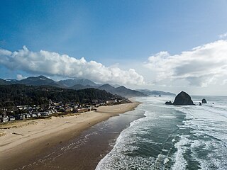
Cannon Beach is a city in Clatsop County, Oregon, United States. Its population was 1,690 at the 2010 census. It is a popular coastal Oregon tourist destination, famous for Haystack Rock, a 235 ft (72 m) sea stack that juts out along the coast. In 2013, National Geographic listed it as "one of the world’s 100 most beautiful places."

The Oregon Coast is a coastal region of the U.S. state of Oregon. It is bordered by the Pacific Ocean to its west and the Oregon Coast Range to the east, and stretches approximately 362 miles (583 km) from the California state border in the south to the Columbia River in the north. The region is not a specific geological, environmental, or political entity, and includes the Columbia River Estuary.

The Clatsop is a small tribe of Chinookan-speaking Native Americans in the Pacific Northwest of the United States. In the early 19th century they inhabited an area of the northwestern coast of present-day Oregon from the mouth of the Columbia River south to Tillamook Head, Oregon.
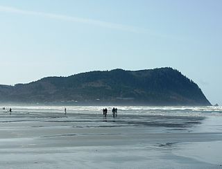
Tillamook Head is a high promontory on the Pacific coast of northwest Oregon in the United States. It is located in west-central Clatsop County, approximately 5 mi (8 km) southwest of Seaside. The promontory forms a steep rocky bluff on the ocean, approximately 1,200 ft high, forested with Sitka spruce. It is located in Ecola State Park.

The Lewis and Clark National Historical Park, located in the vicinity of the mouth of the Columbia River, commemorates the Lewis and Clark Expedition. Administration of the park, which includes both federal and state lands, is a cooperative effort of the National Park Service and the states of Oregon and Washington. The National Historical Park was dedicated on November 12, 2004.

Haystack Rock is a 235 ft-tall (72 m) sea stack in Cannon Beach, Oregon. It is the third-tallest such intertidal structure in the world. A popular tourist destination on the Oregon Coast, the monolithic rock is adjacent to the beach and accessible by foot at low tide. The Haystack Rock tide pools are home to many intertidal animals, including starfish, sea anemone, crabs, chitons, limpets, and sea slugs. The rock is also a nesting site for many sea birds, including terns and puffins.

The Tillamook State Forest is a 364,000-acre (1,470 km2) publicly owned forest in the U.S. state of Oregon. Managed by the Oregon Department of Forestry, it is located 40 miles (64 km) west of Portland in the Northern Oregon Coast Range, and spans Washington, Tillamook, Yamhill, and Clatsop counties. The forest receives large amounts of precipitation and is dominated by Douglas-fir trees. Activities include commercial logging, recreation, and other commercial resource extraction activities such as mushroom hunting.

Oregon Islands National Wildlife Refuge is a U.S. National Wildlife Refuge off the southwestern Oregon Coast. It is one of six National Wildlife Refuges comprising the Oregon Coast National Wildlife Refuge Complex. The Oregon Islands provides wilderness protection to 1,853 small islands, rocks, and reefs plus two headlands, totaling 371 acres (150 ha) spanning 1,083 acres (438 ha) of Oregon's coastline from the Oregon–California border to Tillamook Head. There are sites in six of the seven coastal counties of Oregon. From north to south they are Clatsop, Tillamook, Lincoln, Lane, Coos, and Curry counties. The area is managed by the United States Fish and Wildlife Service.
The Tillamook are a Native American tribe from coastal Oregon of the Salish linguistic group. The name "Tillamook" is a Chinook language term meaning "people of [the village] Nekelim ", sometimes it is given as a Coast Salish term, meaning "Land of Many Waters". The Tillamook tribe consists of several divisions and dialects, including :
Jon M. Erlandson is an archaeologist and Philip H. Knight Professor of Social Sciences in the Department of Anthropology at the University of Oregon, and the director of the University of Oregon Museum of Natural and Cultural History. Erlandson’s research interests include coastal adaptations, the peopling of North America, maritime archaeology and historical ecology and human impacts in coastal ecosystems.
Flye Point 2, also designated Site 42.43 by the Maine Archaeological Survey, is a prehistoric archaeological site in Brooklin, Maine. This site includes a large shell midden, and has yielded evidence of human habitation, including "pit house" features, with an estimated occupation time of 1000 CE. The midden is one of the largest of its type on the coast of eastern Maine. It was listed on the National Register of Historic Places in 1985.
The Cronin Point Site is an archeological site located in Nehalem Bay State Park near Manzanita, Oregon, United States, that was occupied probably between 1600 and 1800 CE. The site is characterized by a significant quantity of burned, fire-cracked rock, indicating the presence of hearths and other cultural activities associated with occupation and a possible village site. Artifacts in the site include stone flaking debris, and a smaller number of projectile points, glass pieces, bone pieces, and shell fragments. Notably, the site also includes shards of Chinese and Japanese ceramicware, datable by their design to ca. 1550–1680 CE, which link the Cronin Point Site to the Nehalem Beeswax Shipwreck. The site spans both submerged and exposed areas; auger-based studies suggest that occupation of the site ended abruptly, likely when the land it rests on subsided due to a large earthquake.
The Smuggler Cove Shell Midden is an archeological site located in Oswald West State Park near Neahkahnie Beach, Oregon, United States. First documented by archeologists in 1976, the midden has been found to contain remains of mussels, barnacles, and chiton to a depth of approximately 30 centimeters (12 in). Radiocarbon dating of a single sample of shell debris indicates that the Smuggler Cove campsite was occupied around 1660 CE, approximately the same date as the supposed wreck of a European ship at nearby Nehalem Spit, suggesting the site may preserve information from both before and after first contact between local people and Europeans. The site has been heavily damaged by construction of recreational facilities and coastal erosion, but a significant portion remains with potential to contribute to future research. Data generated from the site may help answer questions related to environmental change in the Oregon Coast region, settlement and subsistence patterns, emergence of ethnographic patterns among coastal people, the change in cultural patterns from before to after contact with European Americans, and other topics.
The Spruce Tree Site is an archeological site located in Nehalem Bay State Park near Manzanita, Oregon, United States. The site likely represents a precontact/postcontact Nehalem Tillamook campsite used for subsistence activities, including fishing, hunting, food processing, tool manufacture, and related tasks. Radiocarbon dating based on a single sample suggests it may have been occupied as early as 1490 CE. The site has yielded rock flake debris, burned rock, and charcoal, while the presence of glass beads and small fragments of ceramic provide information potential related to early contacts between Europeans and the peoples of the Oregon coast. The porcelain fragments may also link it to the Nehalem Beeswax Shipwreck. The site has been partially eroded, but significant cultural deposits remain above the water line. Submerged stumps amid the site indicate significant subsidence of over 1 meter, possibly related to a large earthquake, which can help answer research questions about the effect of seismic activity on the peoples and landscapes of the Oregon coast as well as on the preservation of cultural remains.
The Osprey Site is an archeological site located near Bandon, Oregon, United States. Associated with the Coquille people, it is the largest known complex of fishing weirs on the Oregon coast, encompassing over 3000 identified wooden weir stakes organized into 25 discrete weir features. Radiocarbon dating suggests the site was in use possibly as early as 560 to 670 CE, and historic accounts indicate it continued in use into the 1850s. The site has also yielded more split wood lattice panels than any other weir location along the Northwest coast. It is a site of outstanding cultural importance to the Coquille people, and great research importance for understanding variation in weir technology during the precontact and postcontact periods.
The High Point Shell Midden is a prehistoric archeological site located in Samuel H. Boardman State Scenic Corridor near Carpenterville, Oregon, United States. The midden is located on a strategic high point overlooking the Pacific coast, and is visible in the eroding cliff face. Radiocarbon dating indicates that the site was occupied c. 1070 CE and again c. 1385 CE, but additional dating may extend this chronology. Although shell deposits are evident without excavation, it is likely that evidence of other activities related to site occupation may be found on the periphery of the midden. The site has potential to produce scientific data related to several topics, including "site formation processes, landscape evolution, and changes in settlement, subsistence, technology, and society among the Native American cultures of the Oregon Coast."
The Tahkenitch Landing Site is a prehistoric archeological site located in Oregon Dunes National Recreation Area near Gardiner, Oregon, United States. Stratified remains up to 2 meters deep show the site has served various functions including shell midden and probably village over a history spanning 7000 to 8000 years, up to as late as 1858 CE. It also bears evidence of dramatic environmental changes including estuarine development, dune formation, and a transition from estuarine to lacustrine habitats. It was the first site on the Oregon coast to yield cultural remains older than about 3000 BP, and as such is one of the most significant sites on the Pacific coast of Oregon and North America.


