
The Lewis and Clark National Historical Park, located in the vicinity of the mouth of the Columbia River, commemorates the Lewis and Clark Expedition. Administration of the park, which includes both federal and state lands, is a cooperative effort of the National Park Service and the states of Oregon and Washington. The National Historical Park was dedicated on November 12, 2004.

Rooster Rock State Park is a state park located east of Corbett, in the U.S. state of Oregon. One of the features of the park is Rooster Rock, a column of basalt forming a natural obelisk, which stands near the south side of the Columbia River Gorge, in the lee of Crown Point. The park is administered by the Oregon Parks and Recreation Department.
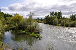
TouVelle State Recreation Site is a state park, administered by Oregon Parks and Recreation Department, and located in Jackson County, Oregon, United States, 9 miles (14 km) north of Medford, where Table Rock Road crosses the Rogue River. This 51-acre (210,000 m2) park is used for fishing, birding, hiking, picnicking and swimming. There is also a boat ramp, which lies at the lower end of an easily navigated stretch of the Rogue. A daily user-fee or annual permit is required.

Milo McIver State Park is a state park in the U.S. state of Oregon. It is in Clackamas County along the Clackamas River, near Estacada and close to Mount Hood.

Lewis and Clark State Recreation Site is a state park in eastern Multnomah County, Oregon, near Troutdale and Corbett, and is administered by the Oregon Parks and Recreation Department. It is located on the Sandy River, near its confluence with the Columbia River. Broughton's Bluff marks the westernmost extent of the Columbia River Gorge at the site.

Nehalem Bay State Park is a state park in the United States located on the Oregon Coast, near the communities of Nehalem and Manzanita on the Nehalem Spit, a sand spit west of Nehalem Bay.

L. L. "Stub" Stewart Memorial State Park is a 1,654-acre (669 ha) Oregon state park in Washington County near the community of Buxton. When the park opened in 2007 it was the first new full-service state park in Oregon since 1972. The park includes hiking trails, mountain bike trails, horseback riding, RV and tent campsites, and cabins among other amenities. Located off Oregon Route 47 in the foothills of the Northern Oregon Coast Range, the park connects to the Banks–Vernonia State Trail.

Tumalo State Park is a well-developed state park in Deschutes County, Oregon, United States. Established in 1954, the park is located northwest of the city of Bend and along the Deschutes River at a site home to many bird species. The park is popular for picnics, swimming, fishing, hiking, and camping, and is open year-round.
Sarah Helmick State Recreation Site, also known as Helmick Park, is a state park located south of Monmouth, in Polk County, Oregon, United States. It is located on the floodplain of the Luckiamute River and is forested by Bigleaf Maple, Douglas-fir, and Black Cottonwood trees, among other varieties. The park is named for Sarah Helmick, a pioneer to Oregon in 1845 who donated the original land. Sarah Helmick State Recreation Site is the first state park established in Oregon. It was listed on the National Register of Historic Places in 2022.

Willamette Mission State Park is a state park in the U.S. state of Oregon, located about four miles (6 km) north of Keizer adjacent to the Wheatland Ferry and east of the Willamette River. It includes Willamette Station Site, Methodist Mission in Oregon, which is listed by the National Register of Historic Places.

Jackson F. Kimball State Recreation Site is a state park in southern Oregon. The park is operated and maintained by the Oregon Parks and Recreation Department, and is located approximately 20 miles (32 km) southeast of Crater Lake National Park and 3 miles (4.8 km) north of Fort Klamath. The park was established in 1955, and covers 19 acres (7.7 ha) including the headwaters of the Wood River.

Erratic Rock State Natural Site is a state park in the Willamette Valley of Oregon, United States. Featuring a 40-short-ton (36 t) glacial erratic from the Missoula Floods, the small park sits atop a foothill of the Northern Oregon Coast Range in Yamhill County between Sheridan and McMinnville off Oregon Route 18. The day use only park is owned and maintained by the Oregon Parks and Recreation Department.

Alfred A. Loeb State Park is a state park in the U.S. state of Oregon, administered by the Oregon Parks and Recreation Department. Located on the banks of the Chetco River, the park offers camping, hiking, fishing, swimming, and rafting opportunities. In the parks boundaries are 3 rental cabins, 53 camping sites, a launch area for drift boats, a day-use area, and the head of a 0.75-mile (1.2 km) trail that the official Web site says leads to northernmost coastal redwood grove in the United States.

Cascadia State Park is a state park in the U.S. state of Oregon near Sweet Home along the South Santiam River at Cascadia. The park includes a day use area, campsites, hiking trails and 150 foot Lower Soda Creek Falls.
Illinois River Forks State Park is a state park in the U.S. state of Oregon, administered by the Oregon Parks and Recreation Department. The park consists of approximately 400 acres, with 170 located between the forks of the Illinois River and the remainder on the west side. The portion between the forks of the river and accessed from Highway 199 just south of Cave Junction, is developed with paved parking, grass lawns with picnic tables, outhouses, and offers a wonderful swimming hole for summer users. The west side of the park, accessed from Westside Road, offers the West Side Trailhead and nearly seven miles of single-track, natural surface hiking and equestrian trails. There is gravelled parking for cars, and a separate pull-through parking lane area for horse rigs. A vault toilet and kiosk with the trail system displayed is in the parking area.

John B. Yeon State Scenic Corridor is a state park in the U.S. state of Oregon, administered by the Oregon Parks and Recreation Department. It is located about 35 miles east of Portland in the Columbia Gorge. It is named in honor of John B. Yeon, one of the principal financiers of the Historic Columbia River Highway U.S. Route 30 which was constructed between 1913 and 1922. Located in the Columbia River Gorge National Scenic Area, the park features hiking trails that access some of the nearby waterfalls, including Elowah Falls.

Munson Creek Falls State Natural Site is a state park in the U.S. state of Oregon, administered by the Oregon Parks and Recreation Department. The park contains Munson Creek Falls, which is the tallest waterfall in Oregon's Coast Range. A short hike of 0.5 miles (0.80 km) leads to views of the 319 feet (97 m) waterfall.
Otter Point State Recreation Site is a state park in the U.S. state of Oregon, administered by the Oregon Parks and Recreation Department.
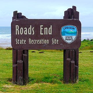
Roads End State Recreation Site is a state park in the U.S. state of Oregon, administered by the Oregon Parks and Recreation Department.
Rocky Creek State Scenic Viewpoint is a state park in Lincoln County in northwestern Oregon, United States. Administered by the Oregon Parks and Recreation Department, the 59-acre (24 ha) park lies along a bluff between Whale Cove and Rocky Creek. The park extends south along the Otter Crest Loop Road to the Rocky Creek Bridge.

