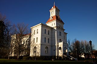
Corvallis is a city and the county seat of Benton County in central western Oregon, United States. It is the principal city of the Corvallis, Oregon Metropolitan Statistical Area, which encompasses all of Benton County. As of the 2020 United States Census, the population was 59,922. Corvallis is the location of Oregon State University and Good Samaritan Regional Medical Center. Corvallis is the westernmost city in the contiguous 48 states with a population larger than 50,000.

The Willamette River is a major tributary of the Columbia River, accounting for 12 to 15 percent of the Columbia's flow. The Willamette's main stem is 187 miles (301 km) long, lying entirely in northwestern Oregon in the United States. Flowing northward between the Oregon Coast Range and the Cascade Range, the river and its tributaries form the Willamette Valley, a basin that contains two-thirds of Oregon's population, including the state capital, Salem, and the state's largest city, Portland, which surrounds the Willamette's mouth at the Columbia.

Rowena is an unincorporated community in Wasco County, Oregon, United States. For statistical purposes, the United States Census Bureau has defined Rowena as a census-designated place (CDP). The census definition of the area may not precisely correspond to local understanding of the area with the same name. The population was 187 at the 2010 census.

The Historic Columbia River Highway is an approximately 75-mile-long (121 km) scenic highway in the U.S. state of Oregon between Troutdale and The Dalles, built through the Columbia River Gorge between 1913 and 1922. As the first planned scenic roadway in the United States, it has been recognized in numerous ways, including being listed on the National Register of Historic Places, being designated as a National Historic Landmark by the U.S. Secretary of the Interior, being designated as a National Historic Civil Engineering Landmark by the American Society of Civil Engineers, and being considered a "destination unto itself" as an All-American Road by the U.S. Secretary of Transportation. The historic roadway was bypassed by the present Columbia River Highway No. 2 from the 1930s to the 1950s, leaving behind the old two-lane road. The road is now mostly owned and maintained by the state through the Oregon Department of Transportation as the Historic Columbia River Highway No. 100 or the Oregon Parks and Recreation Department as the Historic Columbia River Highway State Trail.
The Confluence Project is a series of outdoor installations and interpretive artworks located in public parks along the Columbia River and its tributaries in the U.S. states of Washington and Oregon. Each art installation explores the confluence of history, culture and ecology of the Columbia River system. The project draws on the region's history, including Native American traditional stories and entries from the Lewis and Clark Expedition journals, to "evoke a landscape and a way of life submerged in time and memory." The project reaches from the mouth of the Columbia River to Hells Canyon.

The Lewis and Clark National Historical Park, located in the vicinity of the mouth of the Columbia River, commemorates the Lewis and Clark Expedition. Administration of the park, which includes both federal and state lands, is a cooperative effort of the National Park Service and the states of Oregon and Washington. The National Historical Park was dedicated on November 12, 2004.

Rooster Rock State Park is a state park located east of Corbett, in the U.S. state of Oregon. One of the features of the park is Rooster Rock, a column of basalt forming a natural obelisk, which stands near the south side of the Columbia River Gorge, in the lee of Crown Point. The park is administered by the Oregon Parks and Recreation Department.
Starvation Creek State Park is a state park located west of Hood River, Oregon in the Columbia River Gorge. It was named Starvation Creek because a train was stopped there by snow drifts and passengers had to dig out the train. No one starved there.

Lewis and Clark State Recreation Site is a state park in eastern Multnomah County, Oregon, near Troutdale and Corbett, and is administered by the Oregon Parks and Recreation Department. It is located on the Sandy River, near its confluence with the Columbia River. Broughton's Bluff marks the westernmost extent of the Columbia River Gorge at the site.

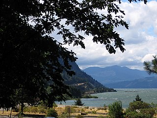
Seneca Fouts Memorial State Natural Area is a state park in northern Hood River County, Oregon, just west of the city of Hood River, and is administered by the Oregon Parks and Recreation Department. It is located in the Columbia River Gorge, adjacent to an abandoned section of the Historic Columbia River Highway. This park is one of a trio encompassing areas in the vicinity of Mitchell Point, along with Vinzenz Lausmann Memorial State Natural Area and Wygant State Natural Area. The three parks offers scenic hiking and views over the Gorge.

The Molalla River State Park is located in U.S. state of Oregon. It is a few miles north of Canby, and half a mile from the Canby Ferry. The park is south of the Willamette River and east of the Molalla River, at the confluence of the Pudding, Molalla and Willamette rivers. The Pudding River flows into the Molalla from the west, just before the Molalla joins the Willamette. The floodplains of these rivers provide important habitat for waterfowl, wading birds, deer, small mammals, reptiles and amphibians. A blue heron rookery, one of the largest in the Willamette Valley, is located in Molalla River State Park.
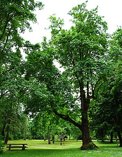
Sarah Helmick State Recreation Site, also known as Helmick Park, is a state park located south of Monmouth, in Polk County, Oregon, United States. It is located on the floodplain of the Luckiamute River and is forested by Bigleaf Maple, Douglas-fir, and Black Cottonwood trees, among other varieties. The park is named for Sarah Helmick, a pioneer to Oregon in 1845 who donated the original land. Sarah Helmick State Recreation Site is first state park established in Oregon.

The Peter Skene Ogden State Scenic Viewpoint is a state park on the Crooked River in Oregon, United States. It is on the border of Deschutes and Jefferson counties.

Sheridan State Scenic Corridor is a state park in the Columbia River Gorge, west of Cascade Locks, Oregon. The 11-acre (4.5 ha) property, containing an old-growth forest, is located on the south side of Interstate 84 at approximately milepoint 42.5, and was not accessible by motor vehicle since I-84 was built in 1960. However, with the opening of the Eagle Creek-Cascade Locks segment of the Historic Columbia River Highway State Trail in 1998, it has become easily accessible by foot or bicycle. The park is on a triangular lot, surrounded by I-84 and the Mount Hood National Forest.

Jackson F. Kimball State Recreation Site is a state park in southern Oregon. The park is operated and maintained by the Oregon Parks and Recreation Department, and is located approximately 20 miles (32 km) southeast of Crater Lake National Park and 3 miles (4.8 km) north of Fort Klamath. The park was established in 1955, and covers 19 acres (7.7 ha) including the headwaters of the Wood River.

Hat Rock State Park is a state park in the U.S. state of Oregon, administered by the Oregon Parks and Recreation Department. The park is located off the east side of U.S. Highway 730 in Hermiston, on the south shore of Lake Wallula behind McNary Dam on the Columbia River.
Illinois River Forks State Park is a state park in the U.S. state of Oregon, administered by the Oregon Parks and Recreation Department. The park consists of approximately 400 acres, with 170 located between the forks of the Illinois River and the remainder on the west side. The portion between the forks of the river and accessed from Highway 199 just south of Cave Junction, is developed with paved parking, grass lawns with picnic tables, outhouses, and offers a wonderful swimming hole for summer users. The west side of the park, accessed from Westside Road, offers the West Side Trailhead and nearly seven miles of single-track, natural surface hiking and equestrian trails. There is gravelled parking for cars, and a separate pull-through parking lane area for horse rigs. A vault toilet and kiosk with the trail system displayed is in the parking area.

John B. Yeon State Scenic Corridor is a state park in the U.S. state of Oregon, administered by the Oregon Parks and Recreation Department. It is located about 35 miles east of Portland in the Columbia Gorge. It is named in honor of John B. Yeon, one of the principal financiers of the Historic Columbia River Highway U.S. Route 30 which was constructed between 1913 and 1922. Located in the Columbia River Gorge National Scenic Area, the park features hiking trails that access some of the nearby waterfalls, including Elowah Falls.

Pistol River State Scenic Viewpoint is a state park in the U.S. state of Oregon, administered by the Oregon Parks and Recreation Department.


