Wallowa County is one of the 36 counties in the U.S. state of Oregon. As of the 2020 census, the population was 7,391, making it Oregon's fifth-least populous county. Its county seat is Enterprise. According to Oregon Geographic Names, the origins of the county's name are uncertain, with the most likely explanation being it is derived from the Nez Perce term for a structure of stakes used in fishing. An alternative explanation is that Wallowa is derived from a Nez Perce word for "winding water". The journals of Lewis and Clark Expedition record the name of the Wallowa River as Wil-le-wah.

Fields Spring State Park is a 828-acre (3.35 km2) public recreation area in the northwest United States, located in southeastern Washington on State Route 129, four miles (6 km), south of Anatone.

Hells Canyon National Recreation Area is a United States national recreation area on the borders of the U.S. states of Oregon and Idaho. Managed by the U.S. Forest Service as part of the Wallowa-Whitman National Forest, the recreation area was established by Congress and signed by President Gerald Ford in late 1975 to protect the historic and archaeological values of the Hells Canyon area and the area of the Snake River between Hells Canyon Dam and the Oregon–Washington border.

The Imnaha River is a 73.3-mile-long (118.0 km) tributary of the Snake River in the U.S. state of Oregon. Flowing generally east near the headwaters and then north through Wallowa County, the entire river is designated Wild and Scenic. It follows a geologic fault to the Snake River, and in addition to land in the Wallowa–Whitman National Forest and private land, its corridor includes parts of three special management areas: the Eagle Cap Wilderness, Hells Canyon National Recreation Area, and Hells Canyon Scenic Byway. The Imnaha flows by the unincorporated community of Imnaha, the only settlement along its course, and enters the Snake River roughly 4 miles (6 km) from the larger river's confluence with the Salmon River of Idaho and 192 miles (309 km) from its confluence with the Columbia River.

The Wallowa–Whitman National Forest is a United States National Forest in the U.S. states of Oregon and Idaho. Formed upon the merger of the Wallowa and Whitman national forests in 1954, it is located in the northeastern corner of the state, in Wallowa, Baker, Union, Grant, and Umatilla counties in Oregon, and includes small areas in Nez Perce and Idaho counties in Idaho. The forest is named for the Wallowa band of the Nez Perce people, who originally lived in the area, and Marcus and Narcissa Whitman, Presbyterian missionaries who settled just to the north in 1836. Forest headquarters are located in Baker City, Oregon with ranger districts in La Grande, Joseph and Baker City.

The Oregon Parks and Recreation Department (OPRD), officially known as the State Parks and Recreation Department, is the government agency of the U.S. state of Oregon which operates its system of state parks. In addition, it has programs to protect and provide public access to natural and historic resources within the state, including the State Historic Preservation Office, Oregon Heritage Commission, Oregon Commission on Historic Cemeteries, recreation trails, the Ocean Shores Recreation Area, scenic waterways and the Willamette River Greenway. The department's chief sources of funding are the Oregon Lottery, state park user fees. and recreation vehicle license fees. The department also manages the system of rest areas along the highways and freeways within the state. In 2006 the department was delegated responsibility for managing the Oregon State Fair.
Chinese Massacre Cove is an area along the Snake River in Wallowa County, Oregon, United States. It is located in the Wallowa–Whitman National Forest and the Hells Canyon National Recreation Area, upriver from the Snake's confluence with the Imnaha River. In May 1887, it was the location of the Hells Canyon Massacre, where thirty-four Chinese gold miners were ambushed and murdered in cold blood.

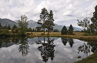
Wallowa Lake is a ribbon lake 1 mile (1.6 km) south of Joseph, Oregon, United States, at an elevation of 4,372 ft (1,333 m). Impounded by high moraines, it was formed by a series of Pleistocene glaciers. On the south end of the lake is a small community made up of vacation homes, lodging, restaurants, as well as other small businesses. Wallowa Lake has been used for recreation since at least 1880. The Wallowa Lake State Park is at the southern tip of the lake.

The Old Chief Joseph Gravesite, also known as Nez Perce Traditional Site, Wallowa Lake, Chief Joseph Cemetery and Joseph National Indian Cemetery is a Native American cemetery near Joseph, Oregon. The area was also a traditional campsite of the Nez Perce and may be archaeologically significant. It was declared a National Historic Landmark in 1985, listed as Wallowa Lake Site. It is a component of the Nez Perce National Historical Park.

Eagle Cap Wilderness is a wilderness area located in the Wallowa Mountains of northeastern Oregon, within the Wallowa–Whitman National Forest. The wilderness was established in 1940. In 1964, it was included in the National Wilderness Preservation System. A boundary revision in 1972 added 73,000 acres (30,000 ha) and the Wilderness Act of 1964 added 66,100 acres (26,700 ha) resulting in a current total of 361,446 acres, making Eagle Cap by far Oregon's largest wilderness area.

Wallowa Lake State Park is a state park located in northeast Oregon in the United States. It is at the southern shore of Wallowa Lake, near the city of Joseph in Wallowa County. The town of Wallowa Lake is situated next to the park.

Koberg Beach State Recreation Site is a state park in Hood River County, Oregon United States, administered by the Oregon Parks and Recreation Department. The park offers a wayside rest area for west bound traffic on Interstate 84.

Minam State Recreation Area is a state park in the U.S. state of Oregon. Administered by the Oregon Parks and Recreation Department, it covers about 600 acres (240 ha) along the Wallowa River north of La Grande in Wallowa County. The park is off Oregon Route 82 about 15 miles (24 km) northeast of Elgin.

Wallowa Lake Highway Forest State Scenic Corridor is a state park in the U.S. state of Oregon, administered by the Oregon Parks and Recreation Department.
Sacajawea Peak is a peak in the Wallowa Mountains, in the U.S. state of Oregon. It is in the Eagle Cap Wilderness and the Wallowa–Whitman National Forest.
Iwetemlaykin State Heritage Site, a public park in the U.S. state of Oregon, is on the south edge of Joseph, along Oregon Route 351. Its name comes from the Nez Perce place name, Iwetemlaykin, which means "at the edge of the lake". The park, near Wallowa Lake, is adjacent to one of the 38 sites of the Nez Perce National Historical Park, the site of the Old Chief Joseph grave and cemetery.
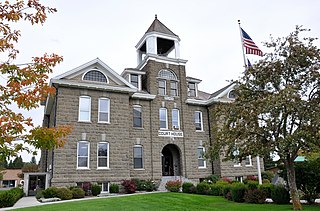
The Wallowa County Courthouse is the seat of government for Wallowa County in northeastern Oregon. The courthouse is located in Enterprise, Oregon. It was built in 1909–1910 using locally quarried stone. It is a massive High Victorian structure built of local Bowlby stone. The courthouse was listed on National Register of Historic Places in 2000. Today, the courthouse still houses Wallowa County government offices.


