
The Mountains-to-Sea State Trail (MST) is a long-distance trail for hiking and backpacking, that traverses North Carolina from the Great Smoky Mountains to the Outer Banks. The trail's western endpoint is at Clingman's Dome, where it connects to the Appalachian Trail in the Great Smoky Mountains National Park. Its eastern endpoint is in Jockey's Ridge State Park on the tallest sand dune on the east coast. The trail is envisioned as a scenic backbone of an interconnected trail system spanning the state. As such, the trail's route attempts to connect as many trail systems and natural scenic areas as practicable. A little over half of the trail is complete in multiple segments across the state.
Smith River National Recreation Area is located northwestern California, United States. The national recreation area is in Six Rivers National Forest and is managed by the U.S. Forest Service, an agency of the U.S. Department of Agriculture. Created by Congress in 1990, Smith River National Recreation Area forms a northern border to Redwood National and State Parks.

Bald Peak State Scenic Viewpoint is a state park located atop Bald Peak located in Yamhill County, in the United States. The day use only park offers picnic tables and a hiking trail for views of the Willamette Valley and the Cascade Range. The state of Oregon acquired the 26 acres (11 ha) in 1931 after Yamhill and Washington counties requested a park from the state.

Samuel H. Boardman State Scenic Corridor is a linear state park in southwestern Oregon, in the United States. It is 12 miles (19 km) long and thickly forested along steep and rugged coastline with a few small sand beaches. It is named in honor of Samuel H. Boardman, the first Oregon Parks superintendent.

H. B. Van Duzer Forest State Scenic Corridor is a 12-mile (19 km) scenic driving route along Route 18 in Lincoln, Tillamook, and Polk counties in the U.S. state of Oregon that passes through a forested corridor. The Van Duzer Corridor stretches from northwestern Polk County to Lincoln City, passing through the Northern Oregon Coast Range.
Battle Mountain Forest State Scenic Corridor is a state park in the U.S. state of Oregon, administered by the Oregon Parks and Recreation Department.
Bolon Island Tideways State Scenic Corridor is a state park in the U.S. state of Oregon, administered by the Oregon Parks and Recreation Department. The 11.4-acre (4.6 ha) park is on Bolon Island 10 river miles (16 km) from the mouth of the Umpqua River and north of Reedsport. It is along Highway 101 and near the site, where in 1828, most of Jedediah Smith's party were massacred. The land was given to the state in 1934 by William C. and Jennie D. Chamberlain.

Booth State Scenic Corridor is a state park in the U.S. state of Oregon, administered by the Oregon Parks and Recreation Department.

Bradley State Scenic Viewpoint is a state park in the U.S. state of Oregon, administered by the Oregon Parks and Recreation Department. It is located directly north of U.S. Route 30 between Astoria and Portland.

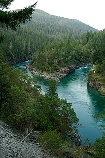
Cape Sebastian State Scenic Corridor is a state park in the U.S. state of Oregon, administered by the Oregon Parks and Recreation Department.

Cascadia State Park is a state park in the U.S. state of Oregon near Sweet Home along the South Santiam River at Cascadia. The park includes a day use area, campsites, hiking trails and 150 foot Lower Soda Creek Falls.

Cline Falls State Scenic Viewpoint is a state park near Redmond, Oregon, United States. It is located on the Deschutes River. The park covers 9 acres (36,000 m2). It is administered by the Oregon Parks and Recreation Department.

John B. Yeon State Scenic Corridor is a state park in the U.S. state of Oregon, administered by the Oregon Parks and Recreation Department. It is located about 35 miles east of Portland in the Columbia Gorge. It is named in honor of John B. Yeon, one of the principal financiers of the Historic Columbia River Highway U.S. Route 30 which was constructed between 1913 and 1922. Located in the Columbia River Gorge National Scenic Area, the park features hiking trails that access some of the nearby waterfalls, including Elowah Falls.

Ukiah–Dale Forest State Scenic Corridor is a state park in the U.S. state of Oregon, administered by the Oregon Parks and Recreation Department.
Umpqua State Scenic Corridor is a state park in the U.S. state of Oregon, administered by the Oregon Parks and Recreation Department.
Unity Forest State Scenic Corridor is a state park in the U.S. state of Oregon, administered by the Oregon Parks and Recreation Department.

Wallowa Lake Highway Forest State Scenic Corridor is a state park in the U.S. state of Oregon, administered by the Oregon Parks and Recreation Department.
Lone Ranch Beach is a beach administered by the Oregon Parks and Recreation Department, as it is part of the Samuel H. Boardman State Scenic Corridor.

Redmond–Bend Juniper State Scenic Corridor is a collection of ten unimproved land parcels administered for the Oregon Parks and Recreation Department. The parcels are located along U.S. Route 97 between Bend and Redmond, Oregon, United States. It is named for the large western juniper trees found on the parcels. The scenic corridor is completely undeveloped with no trails or park facilities of any kind.


