Dallesport is an unincorporated community and census-designated place (CDP) in Klickitat County, Washington, United States. The population was 1,328 at the 2020 census.

Mount Hood is a potentially active stratovolcano in the Cascade Volcanic Arc. It was formed by a subduction zone on the Pacific coast and rests in the Pacific Northwest region of the United States. It is located about 50 mi (80 km) east-southeast of Portland, on the border between Clackamas and Hood River counties. In addition to being Oregon's highest mountain, it is one of the loftiest mountains in the nation based on its prominence, and it offers the only year-round lift-served skiing in North America.
Chinook Jargon is a language originating as a pidgin trade language in the Pacific Northwest. It spread during the 19th century from the lower Columbia River, first to other areas in modern Oregon and Washington, then British Columbia and parts of Alaska, Northern California, Idaho and Montana while sometimes taking on characteristics of a creole language. It is partly descended from the Chinook language, upon which much of its vocabulary is based. Approximately 15 percent of its lexicon is French, and it also makes use of English loanwords and those of other language systems. Its entire written form is in the Duployan shorthand developed by French priest Émile Duployé.

Chinookan peoples include several groups of Indigenous people of the Pacific Northwest in the United States who speak the Chinookan languages. Since at least 4000 BCE Chinookan peoples have resided along the Lower and Middle Columbia River (Wimahl) from the river's gorge downstream (west) to the river's mouth, and along adjacent portions of the coasts, from Tillamook Head of present-day Oregon in the south, north to Willapa Bay in southwest Washington. In 1805 the Lewis and Clark Expedition encountered the Chinook Tribe on the lower Columbia.

The Deschutes River in central Oregon is a major tributary of the Columbia River. The river provides much of the drainage on the eastern side of the Cascade Range in Oregon, gathering many of the tributaries that descend from the drier, eastern flank of the mountains. The Deschutes provided an important route to and from the Columbia for Native Americans for thousands of years, and then in the 19th century for pioneers on the Oregon Trail. The river flows mostly through rugged and arid country, and its valley provides a cultural heart for central Oregon. Today the river supplies water for irrigation and is popular in the summer for whitewater rafting and fishing.

The Blue Mountains are a mountain range in the northwestern United States, located largely in northeastern Oregon and stretching into extreme southeastern Washington. The range has an area of about 15,000 square miles (39,000 km2), stretching east and southeast of Pendleton, Oregon, to the Snake River along the Oregon–Idaho border.

The Lewis and Clark National Historical Park, located in the vicinity of the mouth of the Columbia River, commemorates the Lewis and Clark Expedition. Administration of the park, which includes both federal and state lands, is a cooperative effort of the National Park Service and the states of Oregon and Washington. The National Historical Park was dedicated on November 12, 2004.
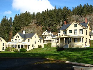
Fort Columbia State Park is a public recreation area and historic preserve at the site of former Fort Columbia, located on Chinook Point at the mouth of the Columbia River in Chinook, Washington. The 618-acre (250 ha) state park features twelve historic wood-frame fort buildings as well as an interpretive center and hiking trails. The park's grounds are located over a tunneled section of U.S. Route 101.

Rooster Rock State Park is a state park located east of Corbett, in the U.S. state of Oregon. One of the features of the park is Rooster Rock, a column of basalt forming a natural obelisk, which stands near the south side of the Columbia River Gorge, in the lee of Crown Point. The park is administered by the Oregon Parks and Recreation Department.

The Multnomah Channel is a 21.5-mile (34.6 km) distributary of the Willamette River. It diverges from the main stem a few miles upstream of the main stem's confluence with the Columbia River in Multnomah County in the U.S. state of Oregon. The channel flows northwest then north around Sauvie Island to meet the Columbia River near the city of St. Helens, in Columbia County.

Central Oregon is a geographic region in the U.S. state of Oregon and is traditionally considered to be made up of Deschutes, Jefferson, and Crook counties. Other definitions include larger areas, often encompassing areas to the north towards the Columbia River, eastward towards Burns, or south towards Klamath Falls. These three counties have a combined population of 200,431 as of the 2010 census, with Deschutes the largest of the three counties, having approximately four times the population of the other two counties combined. As of 2015, the most populous city in the region is Bend, with an estimated 87,014 residents. As defined by the three county definition, Central Oregon covers 7,833 square miles (20,290 km2) of land. Central Oregon has had 3 record tourism years beginning in 2012. Over 2.2 million people visited Central Oregon in 2012 and again in 2013.
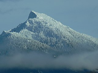
Mount Pilchuck is a mountain located in Snohomish County, Washington. It is 37 miles (60 km) northeast of Seattle. It is part of the Cascade Range.

Comcomly was a Native American leader of the Lower Chinook, a group of Chinookan peoples indigenous to the Pacific Northwest, who inhabited the area near Ilwaco, Washington. Concomly spoke Lower Chinook and was known for his skill with diplomacy and trade.

Lewis and Clark State Recreation Site is a state park in eastern Multnomah County, Oregon, near Troutdale and Corbett, and is administered by the Oregon Parks and Recreation Department. It is located on the Sandy River, near its confluence with the Columbia River. Broughton's Bluff marks the westernmost extent of the Columbia River Gorge at the site.

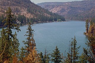
Lake Billy Chinook is a reservoir in Jefferson County in the U.S. state of Oregon. Created by the Round Butte Dam in 1964, Lake Billy Chinook lies in a canyon at the confluence of the Crooked, Deschutes, and Metolius rivers near Culver and Madras. It was named for Billy Chinook, a Native American of the Wasco tribe who traveled alongside American explorers John C. Frémont and Kit Carson in their expeditions of 1843 and 1844.
The Cove Palisades State Park is a state park in eastern Jefferson County, Oregon, near Culver and Madras in the central part of the state, and is administered by the Oregon Parks and Recreation Department. It is located on the waters and surrounding lands of Lake Billy Chinook, an impoundment of the Crooked, Deschutes, and Metolius rivers.

Mayer State Park is a state park in the Columbia River Gorge, near Rowena, Oregon in Wasco County in the U.S. state of Oregon. It consists of several disjointed parcels of transected by Interstate 84 and the tracks of the Union Pacific Railroad.

Sheridan State Scenic Corridor is a state park in the Columbia River Gorge, west of Cascade Locks, Oregon. The 11-acre (4.5 ha) property, containing an old-growth forest, is located on the south side of Interstate 84 at approximately milepoint 42.5, and was not accessible by motor vehicle since I-84 was built in 1960. However, with the opening of the Eagle Creek-Cascade Locks segment of the Historic Columbia River Highway State Trail in 1998, it has become easily accessible by foot or bicycle. The park is on a triangular lot, surrounded by I-84 and the Mount Hood National Forest.

John B. Yeon State Scenic Corridor is a state park in the U.S. state of Oregon, administered by the Oregon Parks and Recreation Department. It is located about 35 miles east of Portland in the Columbia Gorge. It is named in honor of John B. Yeon, one of the principal financiers of the Historic Columbia River Highway U.S. Route 30 which was constructed between 1913 and 1922. Located in the Columbia River Gorge National Scenic Area, the park features hiking trails that access some of the nearby waterfalls, including Elowah Falls.

Blue Lake Regional Park is a public park in Fairview, in the U.S. state of Oregon. The 101-acre (41 ha) park, near the south shore of the Columbia River in Multnomah County, includes many covered and uncovered picnic areas, playing fields for sports such as softball, a cross country course and infrastructure related to lake recreation including swimming, boating, and fishing. Encompassing wooded areas, three ponds, and a wetland in addition to the lake, the park is frequented by migrating birds and other wildlife. Paved paths run through the park, which is near the 40-Mile Loop hiking and biking trail. Park vegetation includes cottonwoods, willows, and other trees and shrubs as well as wetland plants such as cattails.