The Cove Palisades State Park

Last updated
The Cove Palisades State Park
Lake Billy Chinook, Deschutes National Forest, Oregon (photo by Bob Nichol).jpg
USA Oregon location map.svg
Red pog.svg
Usa edcp location map.svg
Red pog.svg
TypePublic, state
Location Jefferson County, Oregon
Nearest city Culver, Oregon
Coordinates 44°32′35″N121°16′30″W / 44.543027°N 121.27512°W / 44.543027; -121.27512 Coordinates: 44°32′35″N121°16′30″W / 44.543027°N 121.27512°W / 44.543027; -121.27512
Operated by Oregon Parks and Recreation Department
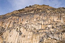
A rock face in Cove Palisades State Park Cove Palisades.jpg
A rock face in Cove Palisades State Park

The Cove Palisades State Park is a state park in eastern Jefferson County, Oregon, near Culver and Madras in the central part of the state, and is administered by the Oregon Parks and Recreation Department. It is located on the waters and surrounding lands of Lake Billy Chinook, an impoundment of the Crooked, Deschutes, and Metolius rivers.

Contents

Visitor opportunities

The park offers two full-service campgrounds, rental cabins, food and supplies for sale, marina access to Lake Billy Chinook with watercraft rentals, fishing, day use and picnic areas, and hiking trails. The park also offers historical interpretation, which includes the Crooked River Petroglyph in the park. There have also been some star parties that have been held at the state park. [1]

Lake Billy Chinook

Lake Billy Chinook lies in canyons carved by the three rivers into earth held in place by basaltic caprock. Construction of the Round Butte Dam was completed in 1964 across the Deschutes River. Operated by Portland General Electric (PGE), and jointly owned by PGE and the Confederated Tribes of Warm Springs, the dam and lake primarily provide electric generation for thousands of homes throughout the state. [2] The Confederated Tribes named the lake in honor of Billy Chinook, a member of the Wasco tribe who acted as a guide in 1843 and 1844 for John C. Frémont and Kit Carson in the region of the lake. The lake extends beyond the boundaries of The Cove Palisades State Park.

Although fish passage facilities were installed at Round Butte Dam, anadromous fish, such as Chinook salmon, have failed to pass the dam. As a result, since the dam's completion migratory fish have been blocked from once-abundant spawning grounds on the upper Deschutes River and tributaries such as the Crooked River. [3]

Research natural area

Embraced by the Crooked River and Deschutes River Arms of Lake Billy Chinook, the isolated, 200-acre (0.81 km2) plateau called "The Island" (actually a peninsula, but with the appearance of an island due to its isolation by high, sheer cliffs) was designated a research natural area in 1986. The Island supports one of the last relatively pristine remnants of pre-settlement ecology in the western United States, and was closed to virtually all public access in 1997. [4]

See also

Related Research Articles

<span class="mw-page-title-main">Deschutes River (Oregon)</span> River in Oregon, United States

The Deschutes River in central Oregon is a major tributary of the Columbia River. The river provides much of the drainage on the eastern side of the Cascade Range in Oregon, gathering many of the tributaries that descend from the drier, eastern flank of the mountains. The Deschutes provided an important route to and from the Columbia for Native Americans for thousands of years, and then in the 19th century for pioneers on the Oregon Trail. The river flows mostly through rugged and arid country, and its valley provides a cultural heart for central Oregon. Today the river supplies water for irrigation and is popular in the summer for whitewater rafting and fishing.

<span class="mw-page-title-main">Portland General Electric</span> Public utility based in Portland, Oregon

Portland General Electric (PGE) is a Fortune 1000 public utility based in Portland, Oregon. It distributes electricity to customers in parts of Multnomah, Clackamas, Marion, Yamhill, Washington, and Polk counties - 44% of the inhabitants of Oregon. Founded in 1888 as the Willamette Falls Electric Company, the company has been an independent company for most of its existence, though was briefly owned by the Houston-based Enron Corporation from 1997 until 2006 when Enron divested itself of PGE during its bankruptcy.

<span class="mw-page-title-main">Bull Run Hydroelectric Project</span> Dam in Oregon

The Bull Run Hydroelectric Project was a Portland General Electric (PGE) development in the Sandy River basin in the U.S. state of Oregon. Originally built between 1908 and 1912 near the town of Bull Run, it supplied hydroelectric power for the Portland area for nearly a century, until it was removed in 2007 and 2008. The project used a system of canals, tunnels, wood box flumes and diversion dams to feed a remote storage reservoir and powerhouse. The entire project was removed because of rising environmental costs. Marmot Dam on the Sandy River was demolished in 2007, and the Little Sandy Dam on the Little Sandy River was taken down in 2008.

<span class="mw-page-title-main">Central Oregon</span> Region in Oregon, United States

Central Oregon is a geographic region in the U.S. state of Oregon and is traditionally considered to be made up of Deschutes, Jefferson, and Crook counties. Other definitions include larger areas, often encompassing areas to the north towards the Columbia River, eastward towards Burns, or south towards Klamath Falls. These three counties have a combined population of 200,431 as of the 2010 census, with Deschutes the largest of the three counties, having approximately four times the population of the other two counties combined. As of 2015, the most populous city in the region is Bend, with an estimated 87,014 residents. As defined by the three county definition, Central Oregon covers 7,833 square miles (20,290 km2) of land. Central Oregon has had 3 record tourism years beginning in 2012. Over 2.2 million people visited Central Oregon in 2012 and again in 2013.

<span class="mw-page-title-main">Metolius River</span> River

The Metolius River is a tributary of the Deschutes River in Central Oregon, United States, near the city of Sisters. The river flows north from springs near Black Butte, then turns sharply east, descending through a series of gorges before ending in the western end of the lake. The unincorporated community of Camp Sherman lies astride the southern end of the river. The name of the river comes from the Warm Springs or Sahaptin word mitula, meaning white salmon and referring to a light colored Chinook salmon and not a whitefish.

<span class="mw-page-title-main">Wasco-Wishram</span>

Wasco-Wishram are two closely related Chinook Indian tribes from the Columbia River in Oregon. Today the tribes are part of the Confederated Tribes of Warm Springs living in the Warm Springs Indian Reservation in Oregon and Confederated Tribes and Bands of the Yakama Nation living in the Yakama Indian Reservation in Washington.

<span class="mw-page-title-main">Lake Billy Chinook</span> Body of water

Lake Billy Chinook is a reservoir in Jefferson County in the U.S. state of Oregon. Created by the Round Butte Dam in 1964, Lake Billy Chinook lies in a canyon at the confluence of the Crooked, Deschutes, and Metolius rivers near Culver and Madras. It was named for Billy Chinook, a Native American of the Wasco tribe who traveled alongside American explorers John C. Frémont and Kit Carson in their expeditions of 1843 and 1844.

<span class="mw-page-title-main">Confederated Tribes of Warm Springs</span> Indian tribe in Oregon, United States

The Confederated Tribes of Warm Springs is a recognized Native American tribe made of three tribes who put together a confederation. They live on and govern the Warm Springs Indian Reservation in the U.S. state of Oregon.

<span class="mw-page-title-main">Crooked River (Oregon)</span> River in Oregon, United States

The Crooked River is a tributary, 125 miles (201 km) long, of the Deschutes River in the U.S. state of Oregon. The river begins at the confluence of the South Fork Crooked River and Beaver Creek. Of the two tributaries, the South Fork Crooked River is the larger and is sometimes considered part of the Crooked River proper. A variant name of the South Fork Crooked River is simply "Crooked River". The Deschutes River flows north into the Columbia River.

<span class="mw-page-title-main">Metolius Springs</span>

Metolius Springs are located just north of Black Butte near the small unincorporated town of Camp Sherman in central Oregon, United States. The springs are the source of the Metolius River, which flows 29 miles (47 km) through the Deschutes National Forest emptying into Lake Billy Chinook. The flow from Metolius Springs is sufficient to create a full-flowing river, making the Metolius River one of the largest spring-fed rivers in the United States. The name of the springs comes from the Warm Springs or Sahaptin word mitula, meaning white salmon and referring to a light colored Chinook salmon and not a whitefish.

Round Butte Dam is a rockfill-type hydroelectric dam on the Deschutes River, in the U.S. state of Oregon.

<span class="mw-page-title-main">Cline Falls State Scenic Viewpoint</span>

Cline Falls State Scenic Viewpoint is a state park near Redmond, Oregon, United States. It is located on the Deschutes River. The park covers 9 acres (36,000 m2). It is administered by the Oregon Parks and Recreation Department.

<span class="mw-page-title-main">Crooked River Ranch, Oregon</span> Unincorporated community in the state of Oregon, United States

Crooked River Ranch is an unincorporated community and census-designated place (CDP) in southern Jefferson County, Oregon, United States. A small portion of the ranch is also in north Deschutes County. The Ranch is located between the Deschutes River and the Crooked River near the south end of Lake Billy Chinook. It is west of U.S. Route 97 between Culver and Terrebonne. Amenities in the community include a golf course, swimming pool, tennis courts, saloon, disc golf course, horse riding arena and general store. The 12,000-acre (49 km2) ranch has a population of approximately 5,000. It is the largest homeowner association in Oregon. Crooked River Ranch has a Terrebonne mailing address, but the postal service also allows mail addressed to Crooked River, Oregon or Crooked River Ranch, Oregon. The ZIP code is 97760.

<span class="mw-page-title-main">Little Sandy River (Oregon)</span> River in Oregon, United States

The Little Sandy River is a tributary, roughly 15 miles (24 km) long, of the Bull Run River in the U.S. state of Oregon. Forming west of Mount Hood in the Mount Hood National Forest, it flows generally west, roughly parallel to the Sandy River to the south. Its entire course lies in Clackamas County, and most of its main stem and tributaries are within the Bull Run Watershed Management Unit (BRWMU), a restricted zone that protects Portland's main water supply.

Billy Chinook was a chief and member of the Wasco tribe. Chinook was a guide for John C. Frémont and Kit Carson, who explored Central Oregon from 1843 to 1844 and from 1845 to 1847. Chinook also served as First Sergeant, U.S. Army Wasco Scouts during the Snake War. Lake Billy Chinook in Oregon is named in his honor.

<span class="mw-page-title-main">Pelton Dam</span>

Pelton Dam is a major dam on the Deschutes River in Jefferson County, Oregon, owned and operated as a hydroelectric facility by Portland General Electric, one element of its Pelton Round Butte Project on the Deschutes.

<span class="mw-page-title-main">Cline Falls</span> Waterfall in Near Redmond, Oregon

Cline Falls is a 20 ft-high (6.1 m) segmented steep cascade waterfall on the Deschutes River. It is approximately 4 miles (6.4 km) west of Redmond, Oregon, United States. The waterfall is named for Cass A. Cline, who owned the land adjacent to the falls in the early 20th century. The falls occur just north of the point where Oregon Route 126 crosses the Deschutes River. The riparian area around Cline Falls provides habitat for a variety of fish and wildlife species.

Metolius Preserve is a conservation preserve owned and managed by the Deschutes Land Trust. It is located near Camp Sherman in Jefferson County, Oregon, USA. Conservation values include old-growth ponderosa pine forest providing habitat for sensitive plants and wildlife, and three segments of Lake Creek with salmon and trout spawning and migration habitat. The Preserve is open to the public for education and recreation. For access information, see the Preserve website.

References

  1. R, Mike (2020-06-03). "Oregon State Parks Star Parties". CosmosPNW. Retrieved 2022-01-18.
  2. PGE – Portland General Electric Company
  3. Deschutes Subbasin Plan, Northwest Power and Conservation Council
  4. Hale, Jamie (October 9, 2016). "Nation & World: A tour of The Island, Oregon's off-limits national landmark". Seattle Times . Culver, Ore. The Associated Press . Retrieved October 10, 2016.