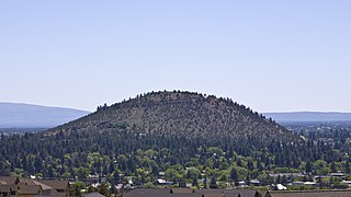
Pilot Butte is a lava dome that was created from an extinct volcano located in Bend, Oregon. It is a cinder cone butte which rises nearly 500 feet (150 m) above the surrounding plains. Bend is one of six cities in the United States to have a volcano within its boundaries. The other examples are Mount Tabor in Portland, Oregon, Jackson Volcano in Jackson, Mississippi, Diamond Head in Honolulu, Glassford Hill in Prescott Valley and Pilot Knob in Austin, Texas.

Heceta Head Light is a lighthouse on the Oregon Coast 13 miles (21 km) north of Florence, and 13 miles (21 km) south of Yachats in the United States. It is located at Heceta Head Lighthouse State Scenic Viewpoint, a state park, midway up a 205-foot-tall (62 m) headland. Built in 1894, the 56-foot (17 m)-tall lighthouse shines a beam visible for 21 nautical miles, making it the strongest light on the Oregon Coast.
Chanticleer Point is a geographical landmark on the Oregon side of the Columbia River Gorge. It is the first notable overlook encountered traveling east on the Historic Columbia River Highway. It is a typical location from which to take photos of the gorge featuring Crown Point and the Vista House prominently. It overlooks Rooster Rock State Park.

The Oregon Parks and Recreation Department (OPRD), officially known as the State Parks and Recreation Department, is the government agency of the U.S. state of Oregon which operates its system of state parks. In addition, it has programs to protect and provide public access to natural and historic resources within the state, including the State Historic Preservation Office, Oregon Heritage Commission, Oregon Commission on Historic Cemeteries, recreation trails, the Ocean Shores Recreation Area, scenic waterways and the Willamette River Greenway. The department's chief sources of funding are the Oregon Lottery, state park user fees. and recreation vehicle license fees. The department also manages the system of rest areas along the highways and freeways within the state. In 2006 the department was delegated responsibility for managing the Oregon State Fair.

L. L. "Stub" Stewart Memorial State Park is a 1,654-acre (669 ha) Oregon state park in Washington County near the community of Buxton. When the park opened in 2007 it was the first new full-service state park in Oregon since 1972. The park includes hiking trails, mountain bike trails, horseback riding, RV and tent campsites, and cabins among other amenities. Located off Oregon Route 47 in the foothills of the Northern Oregon Coast Range, the park connects to the Banks–Vernonia State Trail.

Bald Peak State Scenic Viewpoint is a state park located atop Bald Peak located in Yamhill County, in the United States. The day use only park offers picnic tables and a hiking trail for views of the Willamette Valley and the Cascade Range. The state of Oregon acquired the 26 acres (11 ha) in 1931 after Yamhill and Washington counties requested a park from the state.

The Peter Skene Ogden State Scenic Viewpoint is a state park on the Crooked River in Oregon, United States. It is on the border of Deschutes and Jefferson counties.

Samuel H. Boardman State Scenic Corridor is a linear state park in southwestern Oregon, in the United States. It is 12 miles (19 km) long and thickly forested along steep and rugged coastline with a few small sand beaches. It is named in honor of Samuel H. Boardman, the first Oregon Parks superintendent.

H. B. Van Duzer Forest State Scenic Corridor is a 12-mile (19 km) scenic driving route along Route 18 in Lincoln, Tillamook, and Polk counties in the U.S. state of Oregon that passes through a forested corridor. The Van Duzer Corridor stretches from northwestern Polk County to Lincoln City, passing through the Northern Oregon Coast Range.

Boiler Bay State Scenic Viewpoint is a state park in the U.S. state of Oregon, administered by the Oregon Parks and Recreation Department. The park is one mile (1.6 km) north of Depoe Bay, Oregon.

Bradley State Scenic Viewpoint is a state park in the U.S. state of Oregon, administered by the Oregon Parks and Recreation Department. It is located directly north of U.S. Route 30 between Astoria and Portland.
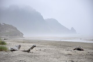
Carl G. Washburne Memorial State Park is a state park in the U.S. state of Oregon, administered by the Oregon Parks and Recreation Department. This park is in Lane County near Florence and Yachats. Very scenic wide beach, great for dogs, kids, kites. Some areas nearby are SNOWY PLOVER protected breeding areas, where dogs are banned, so be careful to keep dogs leashed if uncertain, and always in the State Park itself.

Cline Falls State Scenic Viewpoint is a state park near Redmond, Oregon, United States. It is located on the Deschutes River. The park covers 9 acres (36,000 m2). It is administered by the Oregon Parks and Recreation Department.

Face Rock State Scenic Viewpoint is a state park in Bandon, Oregon, United States, administered by the Oregon Parks and Recreation Department. The rocks and tidal flats adjacent to the park form part of the Oregon Islands National Wildlife Refuge. More than 300 species of birds frequent the area.

Neptune State Scenic Viewpoint is a state park in the U.S. state of Oregon, administered by the Oregon Parks and Recreation Department.

Otter Crest State Scenic Viewpoint is a state park in the U.S. state of Oregon, administered by the Oregon Parks and Recreation Department. Going north on State Highway 101 the turnoff to the left comes up quickly and is easy to miss in the dense foliage. Taking it ones gets a view of Cape Foulweather.

Pistol River State Scenic Viewpoint is a state park in the U.S. state of Oregon, administered by the Oregon Parks and Recreation Department.

Rocky Creek State Scenic Viewpoint is a state park in Lincoln County in northwestern Oregon, United States. Administered by the Oregon Parks and Recreation Department, the 59-acre (24 ha) park lies along a bluff between Whale Cove and Rocky Creek. The park extends south along the Otter Crest Loop Road to the Rocky Creek Bridge.

Redmond–Bend Juniper State Scenic Corridor is a collection of ten unimproved land parcels administered for the Oregon Parks and Recreation Department. The parcels are located along U.S. Route 97 between Bend and Redmond, Oregon, United States. It is named for the large western juniper trees found on the parcels. The scenic corridor is completely undeveloped with no trails or park facilities of any kind.


