
Hood River County is one of the 36 counties in the U.S. state of Oregon. As of the 2020 census, the population was 23,977. The county seat is Hood River. The county was established in 1908 and is named for the Hood River, a tributary of the Columbia River. Hood River County comprises the Hood River, OR Micropolitan Statistical Area. The Hood River Valley produces apples, pears, and cherries. Situated between Mount Hood and the Columbia River in the middle of the Columbia River Gorge, Hood River County is a popular destination for outdoor enthusiasts, such as windsurfers, mountain-bikers, skiers, hikers, kayakers, and many more.

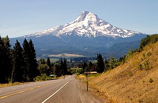
Mount Hood, also known as Wy'east, is an active stratovolcano in the Cascade Range and is a member of the Cascade Volcanic Arc. It was formed by a subduction zone on the Pacific Coast and rests in the Pacific Northwest region of the United States. It is located about 50 mi (80 km) east-southeast of Portland, on the border between Clackamas and Hood River counties, and forms part of the Mount Hood National Forest. Much of the mountain outside the ski areas is part of the Mount Hood Wilderness. With a summit elevation of 11,249 ft, it is the highest mountain in the U.S. state of Oregon and is the fourth highest in the Cascade Range. Ski areas on the mountain include Timberline Lodge ski area which offers the only year-round lift-served skiing in North America, Mount Hood Meadows, Mount Hood Skibowl, Summit Ski Area, and Cooper Spur ski area. Mt. Hood attracts an estimated 10,000 climbers a year.

The Hood River, formerly known as Dog River, is a tributary of the Columbia River in northwestern Oregon, United States. Approximately 25 miles (40 km) long from its mouth to its farthest headwaters on the East Fork, the river descends from wilderness areas in the Cascade Range on Mount Hood and flows through the agricultural Hood River Valley to join the Columbia River in the Columbia River Gorge.

The Mount Hood National Forest is a U.S. National Forest in the U.S. state of Oregon, located 62 miles (100 km) east of the city of Portland and the northern Willamette River valley. The Forest extends south from the Columbia River Gorge across more than 60 miles (97 km) of forested mountains, lakes and streams to the Olallie Scenic Area, a high lake basin under the slopes of Mount Jefferson. The Forest includes and is named after Mount Hood, a stratovolcano and the highest mountain in the state.
The Mount Hood Highway No. 26 is the Oregon Department of Transportation's designation for a 96.74-mile-long (155.69 km) highway from Portland east around the south side of Mount Hood and north via Bennett Pass to Hood River. It is marked as U.S. Route 26 from Portland to near Mount Hood and Oregon Route 35 the rest of the way to Hood River.

The Barlow Road is a historic road in what is now the U.S. state of Oregon. It was built in 1846 by Sam Barlow and Philip Foster, with authorization of the Provisional Legislature of Oregon, and served as the last overland segment of the Oregon Trail. Its construction allowed covered wagons to cross the Cascade Range and reach the Willamette Valley, which had previously been nearly impossible. Even so, it was by far the most harrowing 100 miles (160 km) of the nearly 2,000-mile (3,200 km) Oregon Trail.

The Mount Hood Wilderness is a protected wilderness area inside the Mount Hood National Forest, in the U.S. state of Oregon. The area, covering 64,742 acres (26,200 ha), includes the peak of Mount Hood and its upper slopes, and ranges from temperate rain forests at the lower elevations, to glaciers and rocky ridges at higher elevations.

The Bull of the Woods Wilderness is a wilderness area located in the Mount Hood National Forest in the northwestern Cascades of Oregon, United States. It was created in 1984 and consists of 37,607 acres (15,219 ha) including prime low-elevation old-growth forest, about a dozen lakes of at least 1-acre (4,000 m2) and many large creeks and streams. Adjacent areas, including Opal Creek Wilderness to the west, create a pristine area of nearly 84 square miles (218 km2). There are seven trails that access the wilderness area with an additional seven trails within the protection boundaries themselves. Combined the system provides 75 miles (121 km) of challenging terrain for both pedestrian and equestrian recreation. The name of the peak and thus the wilderness area comes from logging jargon in which the "bull of the woods" was the most experienced logging foreman in an operation.

The Salmon River is a 33.5-mile (53.9 km) river in the Cascade Range in the U.S. state of Oregon that drains part of southwestern Mount Hood. The entire length of the river is a protected National Wild and Scenic River. Several portions are in protected wilderness. It is affluent to the Sandy River, a tributary of the Columbia River.

The Opal Creek Wilderness is a wilderness area located in the Willamette National Forest in the U.S. state of Oregon, on the border of the Mount Hood National Forest. It has the largest uncut watershed in Oregon.

The Table Rock Wilderness is a small pocket wilderness designated in 1984 in the western Cascade Mountains in northwestern Oregon, United States. The wilderness area protects 5,500 acres (2,200 ha) of forest in the historic Molalla River–Pudding River drainage basin, some 19 miles (31 km) southeast of Molalla, Oregon and 50 miles (80 km) southeast of Portland. Somewhat unusual for a wilderness in this area is that it is on BLM land rather the nearby Mount Hood National Forest.

The Mount Thielsen Wilderness is a wilderness area located on and around Mount Thielsen in the southern Cascade Range of Oregon in the United States. It is located within the Deschutes, Umpqua, and Fremont–Winema national forests. It was established by the United States Congress in 1984 and comprises 55,100 acres (22,300 ha).

The Salmon–Huckleberry Wilderness is a wilderness area located on the southern side of Mount Hood in the northwestern Cascades of Oregon, in the United States. It lies within the Mount Hood National Forest and comprises 62,061 acres (25,115 ha) of land. The United States Congress designated the area Wilderness in 1984.

The Mark O. Hatfield Wilderness is a wilderness area located on the northern side of Mount Hood in the northwestern Cascades of the U.S. state of Oregon, near the Columbia River Gorge and within Mount Hood National Forest. Prior to Wilderness designation it was known as the Columbia Gorge Recreation Area.

The Badger Creek Wilderness is a 29,057-acre (11,759 ha) wilderness area located east of Mount Hood in the northwestern Cascades of Oregon, United States. It is one of six designated wilderness areas in the Mount Hood National Forest, the others being Mark O. Hatfield, Salmon-Huckleberry, Mount Hood, Mount Jefferson, and Bull of the Woods.

Eagle Cap Wilderness is a wilderness area located in the Wallowa Mountains of northeastern Oregon, within the Wallowa–Whitman National Forest. The wilderness was established in 1940. In 1964, it was included in the National Wilderness Preservation System. A boundary revision in 1972 added 73,000 acres (30,000 ha) and the Wilderness Act of 1964 added 66,100 acres (26,700 ha) resulting in its current size of 361,446 acres, making Eagle Cap by far Oregon's largest wilderness area.
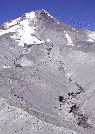
White River Glacier is an alpine glacier located on the south slopes of Mount Hood in the U.S. state of Oregon. It ranges in elevation from about 10,000 to 6,200 feet. It is among the best known of the twelve glaciers on the mountain, and the lower reaches are a popular destination for Nordic skiing enthusiasts. The glacier is the source of the White River, a tributary of the Deschutes River, and has a long history of washing out the bridge where Oregon Route 35 crosses at 45.30307°N 121.67208°W.
Roaring River Wilderness is a wilderness area in the Mount Hood National Forest in Clackamas County, Oregon, United States. Southwest of Mount Hood, Oregon's tallest mountain, the 36,500-acre (14,800 ha) area was created in 2009. The wilderness area is named after the Roaring River that flows through the area and is a tributary of the Clackamas River.

The Clackamas Wilderness is a wilderness area located in the Mount Hood National Forest in the northwestern Cascades of Oregon, United States. Created by the Omnibus Public Land Management Act of 2009, it consists of 9,470 acres (3,830 ha). The wilderness is made up of five different tracts of lands with no roads on a 50-mile (80 km) stretch on both sides of the Clackamas River. These areas include Big Bottom, Memaloose Lake, Clackamas Canyon, Sisi Butte and South Fork Clackamas. It has some of the biggest trees in northwest Oregon. Memaloose Lake is a very popular hiking trail that leads through a forest to the lake, and then continues a mile up to a viewpoint on to up South Fork Mountain.
Mount Hood National Recreation Area is a 34,550-acre (13,980 ha) protected area within Mount Hood National Forest in Oregon, USA. Established on March 30, 2009 by the Omnibus Public Land Management Act of 2009, the national recreation area is managed by the U.S. Forest Service. It comprises three non-contiguous units, none of which include Mount Hood itself, which is mostly within the Mount Hood Wilderness in the national forest. The Mount Hood Unit lies to the southeast of Mount Hood and includes portions of the Badger Creek Wilderness and Mount Hood Wilderness. The Fifteenmile Unit lies directly to the east of the mountain south of Oregon Route 35, and the Shellrock Unit is to the northeast of the mountain, paralleling Route 35.

