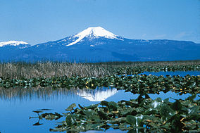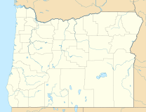
The Klamath Basin National Wildlife Refuge Complex is a wildlife preserve operated by the United States Fish and Wildlife Service in the Klamath Basin of southern Oregon and northern California near Klamath Falls, Oregon. It consists of Bear Valley, Klamath Marsh and Upper Klamath National Wildlife Refuge (NWR) in southern Oregon and Lower Klamath, Tule Lake, and Clear Lake NWR in northern California.

Benton Lake National Wildlife Refuge is a 12,459-acre (5,042 ha) National Wildlife Refuge (NWR) in the central part of the U.S. state of Montana. It lies in northern Cascade County, 12 mi (19 km) north of the city of Great Falls, Montana. Benton Lake NWR includes shortgrass prairie and seasonal wetlands, and is nearly surrounded by the Highwood Mountains to the east, Big Belt Mountains to the south, and the Rocky Mountains to the west. Benton Lake NWR is on the western edge of the northern Great Plains and much of the shallow lake is a 6,000-acre (2,400 ha) wetland.
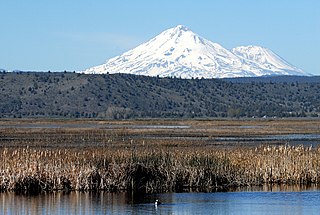
The Lower Klamath National Wildlife Refuge is a National Wildlife Refuge of the United States on the border between California and Oregon. It is operated by the United States Fish and Wildlife Service. The refuge was designated a National Historic Landmark on October 16, 1965.

The Upper Mississippi River National Wildlife and Fish Refuge is a 240,000-acre (970 km2), 261-mile long (420 km) National Wildlife Refuge located in and along the Upper Mississippi River. It runs from Wabasha, Minnesota in the north to Rock Island, Illinois in the south.

Oregon Islands National Wildlife Refuge is a U.S. National Wildlife Refuge off the southwestern Oregon Coast. It is one of six National Wildlife Refuges comprising the Oregon Coast National Wildlife Refuge Complex. The Oregon Islands provides wilderness protection to 1,853 small islands, rocks, and reefs plus two headlands, totaling 371 acres (150 ha) spanning 1,083 acres (438 ha) of Oregon's coastline from the Oregon–California border to Tillamook Head. There are sites in six of the seven coastal counties of Oregon. From north to south they are Clatsop, Tillamook, Lincoln, Lane, Coos, and Curry counties.
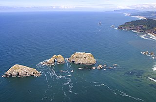
Three Arch Rocks National Wildlife Refuge is a U.S. National Wildlife Refuge off the northern Oregon Coast. It is located on the central coast of Tillamook County, in the northwestern part of Oregon. It is one of six National Wildlife Refuges within the Oregon Coast National Wildlife Refuge Complex and was the first National Wildlife Refuge west of the Mississippi River. In 1970 the Refuge was designated as wilderness. It is one of the smallest wilderness areas in the United States.

Siletz Bay National Wildlife Refuge is a U.S. National Wildlife Refuge on Oregon's coast. It is one of six National Wildlife Refuges (NWRs) comprising the Oregon Coast National Wildlife Refuge Complex. The refuge consists of several discontinuous tracts north and south of the Siletz River where it enters Siletz Bay south of Lincoln City. Previously closed to public use, excluding viewing from outside the refuge boundaries and during special events, the refuge now has a boat launch offering access to non-motorized boats. Alder Island Nature Trail caters to visitors on foot, opened in 2017, and is 0.85 miles (1.37 km) round trip.

Hart Mountain National Antelope Refuge is a National Wildlife Refuge on Hart Mountain in southeastern Oregon, which protects more than 422 square miles (1,090 km2) and more than 300 species of wildlife, including pronghorn, bighorn sheep, mule deer, sage grouse, and Great Basin redband trout. The refuge, created in 1936 as a range for remnant herds of pronghorn, spans habitats ranging from high desert to shallow playa lakes, and is among the largest wildlife habitats containing no domestic livestock.

The Bear Valley National Wildlife Refuge is a wildlife refuge in the southwestern part of Klamath County, Oregon, near the California border. It was established in 1978 to protect the nesting areas of bald eagles. The refuge is part of the Klamath Basin National Wildlife Refuge Complex and has an area of 4,200 acres (1,700 ha) It is administered along with the other refuges in the complex from offices in Tulelake, California.

Clear Lake National Wildlife Refuge is a National Wildlife Refuge of the United States in northeastern California. It includes about 20,000 acres (81 km2) of open water surrounded by over 26,000 acres (110 km2) of upland bunchgrass, low sagebrush, and juniper habitat. small, rocky islands in the wetlands provide breeding sites for American white pelicans, double-crested cormorants, and other colony-nesting birds.

The Target Rock National Wildlife Refuge is located just east of the village of Lloyd Harbor, New York, on the north shore of Long Island, 25 miles (40 km) east of New York City. It is managed by the U.S. Fish and Wildlife Service as part of the Long Island National Wildlife Refuge Complex.

Flattery Rocks National Wildlife Refuge is the northernmost of the three refuges which make up the Washington Maritime National Wildlife Refuge Complex, a group of 870 islands, rocks, and reefs extending for more than 100 miles along Washington's coast from Cape Flattery to Copalis Beach. These islands are protected from human disturbance, yet are close to abundant ocean food sources. They are closed to the public, with wildlife observation only from boats and the mainland, and a 200-yard buffer zone surrounding each island.

Protection Island National Wildlife Refuge is located near the mouth of Discovery Bay in the Strait of Juan de Fuca in Jefferson County, Washington. Approximately 70 percent of the nesting seabird population of Puget Sound and the Strait of Juan de Fuca nest on the island, which includes one of the largest nesting colonies of rhinoceros auklets in the world and the largest nesting colony of glaucous-winged gulls in Washington. The island contains one of the last two nesting colonies of tufted puffins in the Puget Sound area. About 1,000 harbor seals depend upon the island for a pupping and rest area.

Klamath Marsh National Wildlife Refuge was established in 1958 as an inviolate sanctuary, or for any other management purpose, for migratory birds. The refuge primarily consists of 40,000 acres. Originally designated as Klamath Forest National Wildlife Refuge, the Refuge was renamed as virtually all of the historic Klamath Marsh now lies within Refuge boundaries. This large natural marsh provides important nesting, feeding, and resting habitat for waterfowl, while the surrounding meadowlands are attractive nesting and feeding areas for sandhill crane, yellow rail, and various shorebirds and raptors. The adjacent pine forests also support diverse wildlife including the great gray owl and Rocky Mountain elk. During summer months, opportunities to canoe in Wocus Bay allow for wildlife observation and a great scenic route.
Long Island National Wildlife Refuge Complex is a National Wildlife Refuge complex in the state of New York. All of the component refuges are located on Long Island.

Rocky Point is an unincorporated community in Klamath County, Oregon, United States. It is on Pelican Bay on the west shore of Upper Klamath Lake, about 29 miles (47 km) northwest of Klamath Falls and about 3 miles (5 km) north of Oregon Route 140 on Forest Highway 34. It is within the Winema National Forest.

Malone Springs is a watershed within the Fremont-Winema National Forest in Klamath County, Oregon, United States. It is 25 miles northwest of Klamath Falls on mile point 270 43.58 of Oregon Route 140. It provides access to a multi-mile canoe route along the westernmost edge of the Upper Klamath National Wildlife Refuge. Malone Springs' location allows for close encounters with the teeming marsh of Upper Klamath Lake and outstanding views of old growth, mixed conifer forest on neighboring Pelican Butte immediately to the west.

The Neches River National Wildlife Refuge is a 4,404-acre (17.82 km2) protected area of Texas managed by the United States Fish and Wildlife Service as part of the National Wildlife Refuge System. It is located in the rolling hills of East Texas near Jacksonville.
Fortress Island is one of the San Juan Islands in San Juan County, Washington, USA. Located in Lopez Sound, the uninhabited, rocky island has a land area of 3.21 acres and is almost completely devoid of vegetation. It is part of the Turtleback complex, a series of intrusive rocks in Lopez Sound formed out of crystallized molten magma that also includes Bird Rock, Low Island, and others.
