
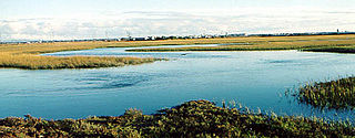
Missisquoi National Wildlife Refuge is a National Wildlife Refuge in the U.S. state of Vermont located on the eastern shore of Lake Champlain and the southern side of Missisquoi Bay. The refuge is in Franklin County in the northwest corner of the state near the International Boundary with Canada.

The Lower Suwannee National Wildlife Refuge (LSNWR) is part of the United States National Wildlife Refuge System. It is located in southeastern Dixie and northwestern Levy counties on the western coast of Florida, approximately fifty miles southwest of the city of Gainesville.

The Klamath Basin National Wildlife Refuge Complex is a wildlife preserve operated by the United States Fish and Wildlife Service in the Klamath Basin of southern Oregon and northern California near Klamath Falls, Oregon. It consists of Bear Valley, Klamath Marsh and Upper Klamath National Wildlife Refuge (NWR) in southern Oregon and Lower Klamath, Tule Lake, and Clear Lake NWR in northern California.

The Lower Klamath National Wildlife Refuge is a National Wildlife Refuge of the United States on the border between California and Oregon. It is operated by the United States Fish and Wildlife Service. The refuge was designated a National Historic Landmark on October 16, 1965.

The Tule Lake National Wildlife Refuge is a National Wildlife Refuge of the United States in northern California near the Oregon border. It covers 39,116 acres (15,830 ha) in the Tule Lake basin. It is part of the Klamath Basin National Wildlife Refuge Complex, and is a crucial part of the Pacific Flyway corridor for migratory birds.

The Atlantic Flyway is a major north-south flyway for migratory birds in North America. The route generally starts in Greenland, then follows the Atlantic coast of Canada, then south down the Atlantic Coast of the United States to the tropical areas of South America and the Caribbean. Every year, migratory birds travel up and down this route following food sources, heading to breeding grounds, or traveling to overwintering sites.

Baskett Slough National Wildlife Refuge is in northwestern Oregon, 10 miles (16 km) west of Salem in Polk County. The Refuge consists of 1,173 acres (4.75 km2) of cropland, which provide forage for wintering geese, 300 acres (1.2 km2) of forests, 550 acres (2.2 km2) of grasslands, and 500 acres (2.0 km2) of shallow water seasonal wetlands and 35 acres (0.14 km2) of permanent open water. In 1965, Baskett Slough National Wildlife Refuge was created to help ensure some of the original habitat remained for species preservation. The refuge is managed by the U.S. Fish and Wildlife Service, an agency of the U.S. Department of the Interior.
Seal Beach National Wildlife Refuge is a wildlife refuge encompassing 965 acres (3.91 km2) located in the California coastal community of Seal Beach. Although it is located in Orange County it is included as part of the San Diego National Wildlife Refuge Complex. It was established in 1972.

The Blackwater National Wildlife Refuge was established in 1933 as a waterfowl sanctuary for birds migrating along the critical migration highway called the Atlantic Flyway. The refuge is located on Maryland's Eastern Shore, just 12 mi (19 km) south of Cambridge, Maryland in Dorchester County, and consists of over 28,000 acres (110 km2) of freshwater impoundments, brackish tidal wetlands, open fields, and mixed evergreen and deciduous forests. Blackwater NWR is one of over 540 units in the National Wildlife Refuge System, which is managed by the United States Fish and Wildlife Service.

The Nomans Land Island Wildlife Refuge is a United States National Wildlife Refuge located on Nomans Land, a 640-acre (2.6 km2) island off the coast of Martha's Vineyard in Massachusetts. It is part of the town of Chilmark, in Dukes County. The Island is 1.6 miles (2.6 km) long east to west, and about 1 mile (1.6 km) north to south. Nomans Land Island was used for aerial gunnery by the U.S. Navy from 1942 to 1996. The United States Fish and Wildlife Service has managed an "overlay" refuge on the Eastern third of the Island under a Joint Management Agreement between the Department of the Interior and Department of the Navy since 1975. Following an extensive surface clearance of ordnance in 1997 and 1998, the Island was transferred to the United States Fish and Wildlife Service to become Nomans Land Island National Wildlife Refuge. It was established ". .. for use as an inviolate sanctuary, or for any other management purpose, for migratory birds" under the Migratory Bird Conservation Act.

The Wood River is a short river in the southern region of the U.S. state of Oregon, and part of the Klamath Basin drainage. It flows 18 miles (29 km) through the Fremont-Winema National Forests, Bureau of Land Management land, and private property in southern Oregon. Its watershed consists of 220 square miles (570 km2) of conifer forest, rural pasture land, and marsh. The river provides habitat for many species of wildlife including an adfluvial (migratory) and resident populations of native Great Basin redband trout.

The Upper Klamath National Wildlife Refuge is a wildlife refuge in southwestern Klamath County on the shores of Upper Klamath Lake in Oregon. It was established in 1928 and contains some 14,400 acres (5,800 ha) of freshwater marshes. It is accessible only by boat from Rocky Point Resort and Rocky Point boat launch, Malone springs, and a few neighboring ramps. The refuge is part of the Klamath Basin National Wildlife Refuge Complex and is administered along with the other refuges of the complex from common offices in Tulelake, California.
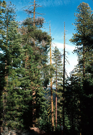
The Bear Valley National Wildlife Refuge is a wildlife refuge in the southwestern part of Klamath County, Oregon, near the California border. It was established in 1978 to protect the nesting areas of bald eagles. The refuge is part of the Klamath Basin National Wildlife Refuge Complex and has an area of 4,200 acres (1,700 ha) It is administered along with the other refuges in the complex from offices in Tulelake, California.
Oxford Slough Waterfowl Production Area is a slough in Franklin and Bannock counties on the edge of Oxford in southeast Idaho. It was purchased in 1985 from the Federal Land Bank using Federal Duck Stamp funds to protect redhead nesting habitat. The area is largely hardstem bulrush marsh, interspersed with open water and surrounded by areas of playa, saltgrass flats, native wet meadow, and some cropland. The lower areas have visible alkali deposits. The marsh is fed on the north and drained at the south by Deep Creek. A smaller creek and several springs feed the marsh from the west. It is managed by Bear Lake National Wildlife Refuge.

Glenn Martin National Wildlife Refuge includes the northern half of Smith Island, which lies 11 miles (18 km) west of Crisfield, Maryland, and Watts Island, which is located between the eastern shore of Virginia and Tangier Island. Both islands are situated in the lower Chesapeake Bay.

Thacher Island National Wildlife Refuge is a National Wildlife Refuge located on Thacher Island near Rockport, Massachusetts. It is managed under the Parker River National Wildlife Refuge. The U.S. Fish and Wildlife Service currently does not offer any interpretive facilities or programs at Thacher Island Refuge. A foot trail meanders through shrub/thicket, rocky outcrop and other island habitats and affords opportunities to observe and/or photograph birds and other island and offshore wildlife.

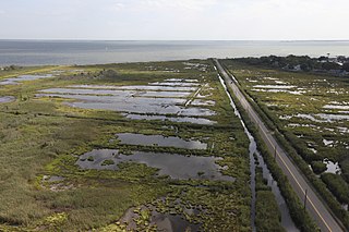
The Supawna Meadows National Wildlife Refuge is a component of the Delaware River estuary in Salem County, New Jersey, it is just north of the Salem River and south of Pennsville.
Seatuck National Wildlife Refuge is located in the hamlet of Islip, New York, on the south shore of Long Island. It is managed by the U.S. Fish and Wildlife Service as part of the Long Island National Wildlife Refuge Complex. The refuge consists of 196 acres (0.79 km2) bordering the Great South Bay, separated from the Atlantic Ocean only by Fire Island. Situated in a heavily developed urban area along Champlin Creek, the refuge is an oasis for many species of migratory birds and waterfowl.

Humboldt Bay National Wildlife Refuge is located on Humboldt Bay, on the California North Coast near the cities of Eureka and Arcata. The refuge exists primarily to protect and enhance wetland habitats for migratory water birds using the bay area, including tens of thousands of shorebirds, ducks, geese, swans, and the black brant. Humboldt Bay National Wildlife Refuge, along with other public and private lands around Humboldt Bay, is one of the key stopovers for the millions of migratory birds that rely on the Pacific Flyway. More than 200 bird species, including 80 kinds of water birds and four endangered species, regularly feed, rest, or nest on the refuge or other areas around the bay.

Malone Springs is a watershed within the Fremont-Winema National Forest in Klamath County, Oregon, U.S. It is 25 miles (40 km) northwest of Klamath Falls on Oregon Route 140. It provides access to a multi-mile canoe route along the westernmost edge of the Upper Klamath National Wildlife Refuge. Malone Springs' location allows for close encounters with the marsh of Upper Klamath Lake and views of old growth, mixed conifer forest on neighboring Pelican Butte immediately to the west.

