Fossil Lake (Oregon)

Last updated

Fossil Lake
Fossil Lake sign, Lake County, Oregon.JPG
Fossil Lake interpretive sign
USA Oregon relief location map.svg
Red pog.svg
Fossil Lake location in Oregon
Location Lake County, Oregon, United States
Coordinates 43°19′33″N120°29′27″W / 43.3258°N 120.4909°W / 43.3258; -120.4909
Area10.2 sq mi (26 km2)
Elevation4,295 ft (1,309 m)
Governing body Bureau of Land Management

Fossil Lake (designated by the Bureau of Land Management as Fossil Lake Area of Critical Environmental Concern) is a dry lakebed in the remote high desert country of northern Lake County in the U.S. state of Oregon. During the Pleistocene epoch, Fossil Lake and the surrounding basin were covered by an ancient lake. Numerous animals used the lake's resources. Over time, the remains of many of these animals became fossilized in the lake sediments. As a result, Fossil Lake has been an important site for fossil collection and scientific study for well over a century. Over the years, paleontologists have found the fossil remains of numerous mammals as well as bird and fish species there. Some of these fossils are 2 million years old.

Contents

Location

Road access map to the Fossil Lake ACEC Fossil Lake map, Lake County, Oregon.jpg
Road access map to the Fossil Lake ACEC

Fossil Lake is located in a remote area of northern Lake County, Oregon. It is 19 miles (31 km) from the unincorporated community of Christmas Valley by road. Fossil Lake is approximately 65 miles (105 km) southeast of Bend and 79 miles (127 km) north of Lakeview by straight-line distance. [1] [2]

From Christmas Valley, visitors travel east on County Road 5–14 (Christmas Valley-Wagontire Road) for 8 miles (13 km), then turn north on County Road 5-14D (Fossil Lake Road). Travel 8 miles (13 km) and then turn east onto the County Road 5-14E (Lost Forest Road), a gravel road. After approximately 1.7 miles (2.7 km), turn south onto a rough unmarked dirt road. The Fossil Lake interpretive sign is approximately 1.4 miles (2.3 km) from the turnoff. Vehicles are not allowed in the Fossil Lake Area of Critical Environmental Concern, so visitors must walk the last 150 yards (140 m) to the Fossil Lake interpretive sign. Fossil Lake itself is 1 mile (1.6 km) southwest of the sign. [1] [2]

Geology and natural history

The bedrock beneath the Fossil Lake area was created by basalt flows laid down during the Pliocene and Pleistocene epochs. After a period of intense faulting during the middle Pleistocene, a large basin area created by horst and graben faulting was modified by erosion and sedimentation. This basin filled with water during the wet climatic periods of the Pleistocene and post-Pleistocene to a depth of 200 feet (61 m). Over the past 3,200 years, the surface water in the Christmas Valley basin including Fossil Lake has completely dried up, leaving a high-desert environment. [1] [3] [4]

The lakebed at Fossil Lake was formed during the post-Pleistocene period from lake sediments and alluvial materials. Pumice sands from Mount Mazama and Newberry Crater also appear in the surface soils throughout the Fossil Lake area. The surface soils are underlain by a hard calcium carbonate caliche layer several inches thick. This subsurface caliche layer is impervious to water drainage and is seldom penetrated by roots. This locally unique water-retentive sub-surface structure has helped the ponderosa pines in nearby Lost Forest Research Natural Area survive in the high-desert environment. [3] [5]

In 1877, there were still two small seasonal ponds at the Fossil Lake site surrounded by a large dry lakebed. The two ponds were called the Fossil Lakes. Since then, both ponds have dried up completely. In addition, the site name is now singular and only applies to the western dry-pond area. [6]

Today, the Fossil Lake site is a dry lakebed above fossil-bearing deposits in the Christmas Valley basin. The area is generally flat with gentle swales. The elevation of the lakebed is 4,295 feet (1,309 m) above sea level. There are large moving sand dunes east of the lakebed. These dunes are made up of lacustrine sediments, aeolian deposits, and alluvial materials with large amounts of volcanic pumice and ash mixed into fine sand that have been blown off the surface of Fossil Lake. [5] [7]

History

The first settlers arrived in the Christmas Lake Valley around 1865. [8] In June 1877, John Whiteaker (a former governor of Oregon) visited the Christmas Valley basin. During the trip, Whiteaker explored the Fossil Lake area, where he found a large dry lakebed with two small alkali ponds in low spots. Whiteaker named the ponds the Fossil Lakes. In addition, he found numerous exposed fossils throughout the area, including elephant, camel, horse, and elk fossils, as well as fossils from animals that Whiteaker could not identify. He noted that horse and bird fossils were particularly plentiful. He also found ancient human artifacts. Whiteaker reported that fossils were scattered across a large swath of desert running from southwest to northeast. He estimated that the fossil beds were 1 mile (1.6 km) wide and over 4 miles (6.4 km) long. After his trip, Whiteaker delivered his fossils to Thomas Condon, a well-known paleontologist and professor at the University of Oregon. [6] [9]

Later that year, Whiteaker's son, J.C. Whiteaker, returned to Fossil Lake with professor Condon. The goal of this second expedition was to more carefully examine and record the numerous fossils scattered around the Fossil Lake site. Condon's discoveries at Fossil Lake attracted the attention of other well-known paleontologists. [6] [10] [11] [12]

After the first site surveys in 1877, numerous paleontologists have visited Fossil Lake to collect fossils and conduct research. [1] In 1879, Professor Edward D. Cope of the Philadelphia Academy of Sciences visited Condon at the University of Oregon and then went to Fossil Lake to collect fossils. [11] [12] [13] Other paleontologists who collected at Fossil Lake during the latter part of the 19th century include O. C. Marsh of Yale University; Charles H. Sternberg, an author and amateur paleontologist; Cope's pupil Jacob L. Wortman of the American Museum of Natural History; and Robert W. Shufeldt, curator of the Army Medical Museum. Both Sternberg and Wortman led expeditions that collected for professor Cope. The Smithsonian Institution also began research at Fossil Lake in the late 1800s. [7] [11] [14] [15] In 1901, Annie M. Alexander visited Fossil Lake to collect fossils. She sent her specimens to University of California. [16] During this period, local settlers reported that fossils were often removed by the wagon load. [14]

After 1906, the number of homesteads in the Christmas Valley basin began to increase. In that year, a post office was opened at Cliff, just north of Fossil Lake. Settlers used the Fossil Lake area for grazing sheep, cattle, and horses. Due to the harsh high-desert conditions, most of the settlers had abandoned their farms by 1920. That was the year the Cliff post office was closed. A prolonged drought in the 1920s and 1930s put an end to dry farming in the region. [8] [17] [18]

Additional fossil collection and research was conducted in the early 20th century. In 1907, David S. Jordan identified some of the fish fossils from the site. In 1911, Loye Holmes Miller identified and described a number of new bird fossils. Stufeldt identified more bird fossils in 1913. He also corrected some misidentified mammal fossils found during previous expeditions. Miller, Oliver P. Hay, and John C. Merriam also studied the age of the Fossil Lake specimens, concluding that the large number of extinct species indicated that the fossil period was older than previously thought. In addition, Chester Stock and E. L. Furlong conducted summers digs at the site of 1923 and 1924. Stock and Furlong sent their finds to the University of California. [14] [16]

In 1977, the Bureau of Land Management placed a temporary ban on vehicles in the Fossil Lake area. The restriction applied to 6,560 acres (2,650 ha) around the dry lakebed. In 1979, the Bureau of Land Management made the vehicle ban permanent. [1] [4] [19] In 1983, the Bureau of Land Management joined Fossil Lake, the neighboring Lost Forest Research Natural Area, and the Christmas Valley Sand Dunes into a single Area of Critical Environmental Concern. Collecting fossils in the Fossil Lake Area of Critical Environmental Concern without a permit from the Bureau of Land Management is prohibited. [1] [5]

In early 1990s, the Bureau of Land Management began working with the South Dakota School of Mines to salvage fossils and conduct paleontological research at Fossil Lake. This collaboration lasted well over a decade. The fossils collected during that project are housed at the South Dakota School of Mines campus in Rapid City, South Dakota. [7]

In 2017, a team from the University of Oregon with the assistance of the Bureau of Land Management discovered a trail of Columbian mammoth footprints. The track included 117 individual mammoth prints in a 66 feet (20 m) by 25 feet (7.6 m) area of the lakebed. Scientists believe the tracks were made approximately 43,000 years ago. [20]

Fossils

The fossil-bearing deposits at Fossil Lake cover at least 10,000 acres (4,000 ha). Over the years, there have been numerous expeditions to collect fossils at the Fossil Lake site. The site has produced more Holocene fossils than any other location in the world except the La Brea Tar Pits in California. [7] Fossil discoveries have included at least 23 mammal species, [16] 74 bird species, 7 fish species, and 11 mollusk species. Some of the large mammal fossils found at the site include Columbian mammoths, ground sloths, dire wolves, giant beavers, pre-historic bison, three species of camels, several horse species, peccary, and an extinct bear. Bird fossils include flamingos, pelicans, and swans, and large eagle species. Fish fossils include tui chub and several salmon species. Two-thirds of the fossil species collected at Fossil Lake are extinct. [1] [4] [7] [21]

Columbian mammoths once lived around Fossil Lake Mammuthus columbi.jpg
Columbian mammoths once lived around Fossil Lake

The extent of the fossil beds at the Fossil Lake site is still unknown; stratigraphically specific rock layers laid down at different periods each contain characteristic fossils of different animals. The fossil deposits from the Holocene epoch are between 8,000 and 50,000 years old. There are also Fossil Lake artifacts that indicate that humans may have hunted in this area near the end of this period. Some prey may have been large mammals that are now extinct. The oldest fossils from the site date back to the Pleistocene epoch. These fossils are up to 2 million years old. [4] [7]

The Bureau of Land Management has identified several environmental concerns with regard to the Fossil Lake site. First, the fossil deposits extend beyond the boundary of the existing restricted area. As a result, there is a risk that vehicles or grazing livestock may damage unprotected fossils. Second, illegal fossil collecting is a potential problem. Finally, loose surface sediments at Fossil Lake continue to erode, exposing new fossils each year. When fossils are first exposed, they are often found as articulated skeletons. However, the remains are quickly scattered due to wind action. Sandy sediments carried by the wind also cause rapid weathering once the fossils are exposed. As a result, scientists try to collect the newly exposed fossils as soon as possible. [7]

Today, large fossil collections from the Fossil Lake site are maintained by the University of Oregon, the Smithsonian Institution, the South Dakota School of Mines, the University of California at Los Angeles, and the University of California at Berkeley. [7] [12] [22]

Environment

High desert landscape at Fossil Lake Fossil Lake landscape, Lake County, Oregon.JPG
High desert landscape at Fossil Lake

Based on National Weather Service data recorded at Cliff between 1908 and 1916 and other nearby weather reporting stations, the mean annual temperature in the Fossil Lake area is 43 °F (6 °C). The hottest and driest months are July and August, with a peak average temperature of 63 °F (17 °C). The coldest months are December and January. The average daily temperature in December is 30 °F (−1 °C) and 28 °F (−2 °C) in January. The mean annual precipitation at Fossil Lake is 8.7 inches (22 cm) per year. The wettest months are December and January, with a smaller peak period in May and June. However, weather patterns in this area are very erratic. For example, there was an extremely severe drought throughout the 1920s and early 1930s. [3]

The Fossil Lake area supports a plant community dominated by big sagebrush, low sagebrush, silver sagebrush, green rabbitbrush (also called yellow rabbitbrush), rubber rabbitbrush, and greasewood. There are a number of perennial grasses common in the Fossil Lake area, including Sandberg bluegrass, needle-and-thread grass, Indian ricegrass, creeping wildrye, and invasive cheatgrass. Perennial flowering plants found in the Fossil Lake area include prickly-phlox, lemon scrufpea common wooly sunflower, and Townsend daisy, and spiny hopsage. [23] [24]

Wildlife

The animal population around Fossil Lake is typical of the high desert country of south-central Oregon. The larger mammals include pronghorn, American badger, and coyotes. Black-tailed jackrabbits, Ord's kangaroo rats, deer mice, Great Basin pocket mice, and northern grasshopper mice are among the smaller animals found in the Fossil Lake area. There also 13 bat species that live in the desert around Fossil Lake. [25] [26] In 1917, a diminutive bear was killed near Fossil Lake. Originally, it was thought that the bear might be a unique species, a lava bear. A photograph of the bear was published in Oregon Sportsman magazine in October 1917. Eventually, it was determined that the specimen was an unusually small American black bear stunted from malnutrition. [27] [28] [29] [30]

Fossil Lake is home to a number of bird species as well. They include greater sage-grouse, black-billed magpie, pinyon jay, Brewer's blackbird, American robin, mountain bluebird, sage thrasher, Sagebrush sparrow, and loggerhead shrike. There are also birds of prey such as prairie falcon, red-tailed hawks, and golden eagles. [25] [26]

There are a number of reptiles found in the Fossil Lake area, both snakes and lizards. Snakes found in the area around Fossil Lake include western rattlesnakes, gopher snakes, striped whipsnakes, and night snakes. Common lizards include sagebrush lizards, short-horned lizards, side-blotched lizards, western fence lizards, and western skinks. [26]

Related Research Articles

<span class="mw-page-title-main">Lake County, Oregon</span> County in Oregon, United States

Lake County is one of the 36 counties in the U.S. state of Oregon. As of the 2020 census, the population was 8,160. Its county seat is Lakeview. The county is named after the many lakes found within its boundaries, including Lake Abert, Summer Lake, Hart Lake, and Goose Lake.

<span class="mw-page-title-main">John Day Fossil Beds National Monument</span> National monument in Oregon, United States

John Day Fossil Beds National Monument is a U.S. national monument in Wheeler and Grant counties in east-central Oregon. Located within the John Day River basin and managed by the National Park Service, the park is known for its well-preserved layers of fossil plants and mammals that lived in the region between the late Eocene, about 45 million years ago, and the late Miocene, about 5 million years ago. The monument consists of three geographically separate units: Sheep Rock, Painted Hills, and Clarno.

<span class="mw-page-title-main">Lake Abert</span> A highly-saline lake in Oregon, United States

Lake Abert is a large, shallow, alkali lake in Lake County, Oregon, United States. It is approximately 15 mi (24 km) long and 7 mi (11 km) wide at its widest point. It is located 3 mi (4.8 km) northeast of the small, unincorporated community of Valley Falls, Oregon. The lake was named in honor of Colonel John James Abert by explorer John C. Fremont during his 1843 expedition into Central Oregon. No fish live in the alkaline waters of the lake; however, its dense population of brine shrimp supports a variety of shorebirds. The lake is an important stop on the bird migration route known as the Pacific flyway.

<span class="mw-page-title-main">Malheur National Wildlife Refuge</span> Protected area in eastern Oregon, USA

Malheur National Wildlife Refuge is a National Wildlife Refuge located roughly 30 miles (48 km) south of the city of Burns in Oregon's Harney Basin. Administered by the United States Fish and Wildlife Service, the refuge area is roughly T-shaped with the southernmost base at Frenchglen, the northeast section at Malheur Lake and the northwest section at Harney Lake.

<span class="mw-page-title-main">Christmas Valley, Oregon</span> Unincorporated community in the state of Oregon, United States

Christmas Valley is an unincorporated community in Lake County, Oregon, United States. The community was named after nearby Christmas Lake, usually dry, east of the present town and the site of the former Lake post office, which ran from 1906 until 1943. Real estate development around a planned community by M. Penn Phillips, called Christmas Valley, started after World War II. The Christmas Valley post office was established in 1963 as a rural station of Silver Lake.

<span class="mw-page-title-main">High Desert (Oregon)</span> A region of the U.S. state of Oregon

The Oregon High Desert is a region of the U.S. state of Oregon located east of the Cascade Range and south of the Blue Mountains, in the central and eastern parts of the state. Divided into a southern region and a northern region, the desert covers most of five Oregon counties and averages 4,000 feet (1,200 m) above sea level. The southwest region is part of the Great Basin and the southeast is the lower Owyhee River watershed. The northern region is part of the Columbia Plateau, where higher levels of rainfall allow the largest industry on private land to be the cultivation of alfalfa and hay. Public land within the region is owned primarily by the Bureau of Land Management, which manages more than 30,000 square miles (78,000 km2) including five rivers designated as Wild and Scenic.

<span class="mw-page-title-main">Columbia Plateau (ecoregion)</span> Xeric shrubland ecoregion of Canada and the United States

The Columbia Plateau ecoregion is a Level III ecoregion designated by the United States Environmental Protection Agency (EPA) encompassing approximately 32,100 square miles (83,139 km2) of land within the U.S. states of Washington, Oregon, and Idaho. The ecoregion extends across a wide swath of the Columbia River Basin from The Dalles, Oregon to Lewiston, Idaho to Okanogan, Washington near the Canada–U.S. border. It includes nearly 500 miles (800 km) of the Columbia River, as well as the lower reaches of major tributaries such as the Snake and Yakima rivers and the associated drainage basins. It is named for the Columbia Plateau, a flood basalt plateau formed by the Columbia River Basalt Group during the late Miocene and early Pliocene. The arid sagebrush steppe and grasslands of the region are flanked by moister, predominantly forested, mountainous ecoregions on all sides. The underlying basalt is up to 2 miles (3 km) thick and partially covered by thick loess deposits. Where precipitation amounts are sufficient, the deep loess soils have been extensively cultivated for wheat. Water from the Columbia River is subject to resource allocation debates involving fisheries, navigation, hydropower, recreation, and irrigation, and the Columbia Basin Project has dramatically converted much of the region to agricultural use.

<span class="mw-page-title-main">Northern Basin and Range ecoregion</span>

The Northern Basin and Range ecoregion is a Level III ecoregion designated by the United States Environmental Protection Agency (EPA) in the U.S. states of Oregon, Idaho, Nevada, Utah, and California. It contains dissected lava plains, rolling hills, alluvial fans, valleys, and scattered mountain ranges in the northern part of the Great Basin. Although arid, the ecoregion is higher and cooler than the Snake River Plain to the north and has more available moisture and a cooler climate than the Central Basin and Range to the south. Its southern boundary is determined by the highest shoreline of Pleistocene Lake Bonneville, which once inundated the Central Basin and Range. The western part of the region is internally drained; its eastern stream network drains to the Snake River system.

<span class="mw-page-title-main">Christmas Valley Sand Dunes</span> Natural sand dune complex in Lake County, Oregon, United States

The Christmas Valley Sand Dunes are a natural sand dune complex covering 11,000 acres (45 km2) of public lands east of Christmas Valley in Lake County, Oregon, United States, about 100 miles (160 km) southeast of Bend. The area is accessible via the Christmas Valley National Back Country Byway. The dunes are up to 60 feet (18 m) high. It is the largest inland shifting sand dune system in the Pacific Northwest. The dunes are composed mostly of ash and pumice from the eruption of Mount Mazama that formed Crater Lake 7,000 years ago. Approximately 8,900 acres (36 km2) of dunes are open to vehicles.

<span class="mw-page-title-main">Lost Forest Research Natural Area</span> Protected area in the United States

The Lost Forest Research Natural Area is a designated forest created by the Bureau of Land Management to protect an ancient stand of ponderosa pine in the remote high desert county of northern Lake County, in the south central area of the U.S. state of Oregon. Lost Forest is an isolated area of pine trees separated from the nearest contiguous forest land by forty miles of arid desert. There are no springs or surface water in Lost Forest, and much of the southwest portion of the natural area is covered by large shifting sand dunes that are slowly encroaching on the forest.

<span class="mw-page-title-main">Warner Valley</span> Valley in south-central Oregon

The Warner Valley is a valley in south-central Oregon in the United States. It is a remote valley at the northwestern corner of North America's Basin and Range Province. The valley is home to a chain of lakes and wetlands known as the Warner Lakes. Native Americans were present in the Warner Valley for thousands of years before European explorers arrived in the 19th century. It is the site of Fort Warner, built by the United States Army in 1867. The fort was used as a supply depot and administrative headquarters during a protracted Army campaign against Northern Paiute bands in eastern Oregon and northern California. Today, livestock ranching is the main commercial activity in the valley. The Warner Valley offers a number of recreational opportunities including hunting, fishing, bird watching, and wildlife viewing.

<span class="mw-page-title-main">Warner Lakes</span> Endorheic lake in Oregon, United States

The Warner Lakes are a chain of shallow lakes and marshes in the Warner Valley of eastern Lake County, Oregon, United States. The lakes extend the length of the valley, covering approximately 90,000 acres (360 km2).

<span class="mw-page-title-main">Hart Lake (Oregon)</span> Lake of the United States of America

Hart Lake is a shallow lake in the Warner Valley of eastern Lake County, Oregon, United States. The lake covers 7,324 acres (29.64 km2) and has the most stable water level within the valley's Warner Lakes chain. The lake is named for the heart-shaped brand used by the pioneer Wilson and Alexander cattle ranch established near the lake. Much of the land around Hart Lake is administered by the Bureau of Land Management (BLM) and the United States Fish and Wildlife Service (FWS). The lake and the surrounding wetlands support a wide variety of birds and other wildlife. Recreational opportunities on and near Hart Lake include hunting, fishing, bird watching, and boating.

<span class="mw-page-title-main">Goose Lake Valley</span> Valley in south-central Oregon and northeastern California

The Goose Lake Valley is located in south-central Oregon and northeastern California in the United States. It is a high valley at the northwestern corner of North America's Great Basin. Much of the valley floor is covered by Goose Lake, a large endorheic lake that straddles the Oregon–California border. Native Americans inhabited the Goose Lake Valley for thousands of years before explorers arrived in the 19th century. The pioneer wagon route known as the Applegate Trail crossed the Goose Lake Valley on its way to southern Oregon. At the south end of Goose Lake, the Lassen Cutoff separated from the Applegate Trail and headed south toward the Sacramento Valley. Today, Lakeview, Oregon, is the largest settlement in the valley. Livestock ranching and lumber mills are the valley's main commercial activity. The Goose Lake Valley offers a number of recreational opportunities including hang-gliding, hunting, fishing, and birdwatching.

<span class="mw-page-title-main">Paleontology in Oregon</span>

Paleontology in Oregon refers to paleontological research occurring within or conducted by people from the U.S. state of Oregon. Oregon's geologic record extends back approximately 400 million years ago to the Devonian period, before which time the state's landmass was likely submerged under water. Sediment records show that Oregon remained mostly submerged until the Paleocene period. The state's earliest fossil record includes plants, corals, and conodonts. Oregon was covered by seaways and volcanic islands during the Mesozoic era. Fossils from this period include marine plants, invertebrates, ichthyosaurs, pterosaurs, and traces such as invertebrate burrows. During the Cenozoic, Oregon's climate gradually cooled and eventually yielded the environments now found in the state. The era's fossils include marine and terrestrial plants, invertebrates, fish, amphibians, turtles, birds, mammals, and traces such as eggs and animal tracks.

<span class="mw-page-title-main">Catlow Valley</span> Basin in Oregon, United States

The Catlow Valley is a basin in Harney County, Oregon, United States. It is a remote valley at the northwestern corner of North America's Basin and Range Province. The valley is named after a pioneer rancher, John Catlow. The area was used by Native Americans for thousands of years before European explorers arrived in the 19th century. Today, cattle ranching is the main commercial activity in the valley. The public land in the Catlow Valley is administered by the Bureau of Land Management. This public land offers a number of recreational opportunities including hiking, hunting, fishing, bird watching, and wildlife viewing.

<span class="mw-page-title-main">Gerber Reservoir</span> Reservoir in Oregon, USA

Gerber Reservoir is an irrigation impoundment created by Gerber Dam. It is located in southern Klamath County, Oregon, United States. The reservoir covers 3,815 acres (1,544 ha). The dam and reservoir are named in honor of Louis C. Gerber, an early pioneer who owned much of the land flooded by the reservoir. Today, the reservoir and surrounding property is owned by the United States Government. It is administered by the Bureau of Reclamation and the Bureau of Land Management. Gerber Reservoir is a popular outdoor recreation site with two campgrounds along its west shore.

<span class="mw-page-title-main">Hager Mountain</span>

Hager Mountain is a volcanic peak in Oregon in the northwest corner of the Basin and Range Province in the United States. The mountain is located south of the small unincorporated community of Silver Lake in south-central Oregon, and it is in the Fremont–Winema National Forest. On the summit, there is a fire lookout operated during the summer and fall by the United States Forest Service. There are several hiking trails that lead to the lookout station.

<span class="mw-page-title-main">Crump Lake (Oregon)</span> Natural lake in Oregon, US

Crump Lake is a shallow lake in the Warner Valley of eastern Lake County, Oregon, United States. The lake covers 7,680 acres (31.1 km2). It is the largest of the Warner Lakes system. The lake is named for pioneer rancher Thomas Crump. Crump Lake is owned by the Oregon Department of State Lands. Much of the land around the lake is administered by the Bureau of Land Management and the United States Fish and Wildlife Service. The lake and the surrounding wetlands support a wide variety of birds and other wildlife. Recreational opportunities on or near Crump Lake include fishing, bird watching, and camping.

<span class="mw-page-title-main">Burma Rim</span> Geological formation in Oregon

Burma Rim is a geological feature in the high desert of Lake County, Oregon between Christmas Valley, Oregon to the west and Wagontire, Oregon to the east. The rim was formed when it was the shoreline of a pleistocene era lake. The area is currently overseen by the Lakeview District of the Bureau of Land Management (BLM). The BLM inventoried the area. It spans 90,397 acres and includes a private inholding held by a local conservation group since 2017.

References

  1. 1 2 3 4 5 6 7 Lost Forest Research Natural Area Archived 23 September 2015 at the Wayback Machine (PDF), Christmas Valley Sand Dunes Area of Critical Environmental Concern, Lakeview District, Bureau of Land Management, United States Department of Interior, Lakeview, Oregon, 2005.
  2. 1 2 Fossil Lake geo-location, Oregon topographic map, United States Geological Survey, United States Department of Interior, Reston, Virginia; displayed via ACME mapper, www.acme.com, 5 August 2014.
  3. 1 2 3 Moir, William H., Jerry F. Franklin, and Chris Maser, "Environment" (PDF), Lost Forest Research Natural Area, Pacific Northwest Forest and Range Experiment Station, United States Forest Service, Department of Agriculture, Portland, Oregon, 1973, pp. 6–8.
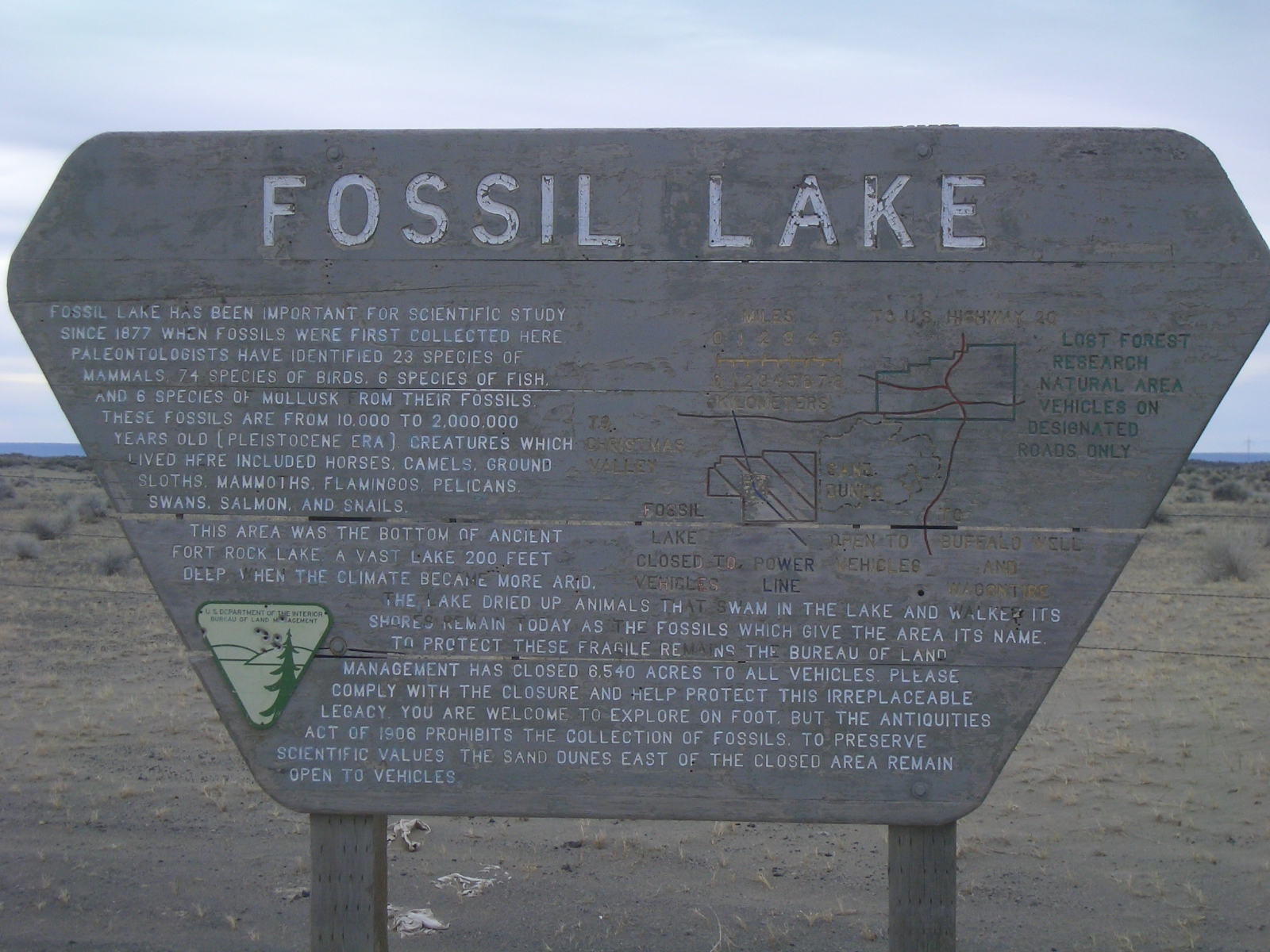
  4. 1 2 3 4 "Fossil Lake", interpretive sign, Bureau of Land Management, United States Department of Interior, posted at entrance to Fossil Lake Area of Critical Environmental Concern near Christmas Valley, Oregon, erected prior to 2010.
  5. 1 2 3 Chadwick, Kristen L. and Andris Eglitis, Health Assessment of the Lost Forest Research Natural Area (PDF), Central Oregon Service Center for Insects and Diseases, United States Forest Service, United States Department of Agriculture, Bend, Oregon, February 2007, pp. 1–2.
  6. 1 2 3 McArthur, Lewis A. and Lewis L. McArthur, "Fossil Lake", Oregon Geographic Names (Seventh Edition), Oregon Historical Society Press, Portland, Oregon, 2003, p. 376.
  7. 1 2 3 4 5 6 7 8 "Areas of Critical Environmental Concern", Proposed Lakeview Resource Management Plan and Final Environmental Impact Statement, Lakeview District, Bureau of Land Management, United States Department of Interior, Lakeview, Oregon, January 2003, pp. 2.65–2.67.
  8. 1 2 Moir, William H., Jerry F. Franklin, and Chris Maser, "History of Disturbance" (PDF), Lost Forest Research Natural Area, Pacific Northwest Forest and Range Experiment Station, United States Forest Service, Department of Agriculture, Portland, Oregon, 1973, p. 15.
  9. J. W. (John Whiteaker), "A Trip to the Fossil Beds", Eugene City Guard, Eugene, Oregon, 29 September 1877, p. 3.
  10. Mack, Tony, "Thomas Condon: Oregon's Grand Old Fossil Man", Horizons insert, The Bulletin, Bend, Oregon, 26 April 1993, pp. 5–6.
  11. 1 2 3 Brogan, Phil F., East of the Cascades, Binfords and Mort, Portland, Oregon, 1965, pp. 7–8.
  12. 1 2 3 Hatton, Raymond L., High Desert of Central Oregon, Binford and Mort, Caldwell, Idaho, 1977, pp. 126–139.
  13. "Southern Oregon", The Oregonian, Portland, Oregon, 5 November 1879, p. 1.
  14. 1 2 3 Ashwill, Melvin S., "Paleontology in Oregon: Workers of the Past" (PDF), Oregon Geology, Oregon Department of Geology and Mineral Industries, Portland, Oregon, December 1987, pp. 147–149.
  15. Brogan, Phil F., "Fossil Lake Story Retold", The Sunday Oregonian, Portland, Oregon, 7 March 1954, p. 35.
  16. 1 2 3 Elftman, Hert Oliver, Pleistocene Mammals of Fossil lake, Oregon, American Museum Novitates (Number 481), American Museum of Natural History, New York City, New York, 14 July 1931, pp. 3–5.
  17. McArthur, Lewis A. and Lewis L. McArthur, "Cliff", Oregon Geographic Names (Seventh Edition), Oregon Historical Society Press, Portland, Oregon, 2003, p. 209.
  18. Waring, Gerald A., "Christmas Lake Valley" (PDF), Geology and Water Resources of a Portion of South-Central Oregon, Water-Supply Paper 22O, United States Geological Survey, United States Department of Interior, Washington, District of Columbia, 1908, pp. 59–61.
  19. "Fossil Lake Area Closed to Vehicles Permanently", Eugene Register-Guard, Eugene, Oregon, 9 October 1979, p. B1.
  20. Liedthe, Kurt, "Fossil Lake Gets More Fossils: Columbian Mammoth Tracks", The Bulletin, Bend, Oregon, 6 March 2018, p.A2.
  21. Brogan, Phil F., "Wind Whips Fossil bed", The Sunday Oregonian, Portland, Oregon, 17 May 1970, p. RE14.
  22. "Condon Fossil Collection" Archived 21 July 2011 at the Wayback Machine , Museum of Natural and Cultural History, University of Oregon, Eugene, Oregon, 5 August 2014.
  23. "Sand Dunes Road Maintenance and Re-Alignment OR-L050-2009-0063-EA" (PDF), Notice of Availability Environmental Assessment and Finding of No Impact, Lakeview Resource Area, Bureau of land Management, United States Department of Interior, Lakeview, Oregon, 17 August 2009, pp. 6–7.
  24. Moir, William H., Jerry F. Franklin, and Chris Maser, "Plant Communities" (PDF), Lost Forest Research Natural Area, Pacific Northwest Forest and Range Experiment Station, United States Forest Service, Department of Agriculture, Portland, Oregon, 1973, p. 13.
  25. 1 2 "Wildlife list for Fossil Lake" Archived 26 October 2014 at the Wayback Machine , Oregon Wildlife Explorer, National Resources Digital Library, Oregon State University Libraries, Oregon State University, Corvallis, Oregon, 5 August 2014.
  26. 1 2 3 Moir, William H., Jerry F. Franklin, and Chris Maser, "Fauna" (PDF), Lost Forest Research Natural Area, Pacific Northwest Forest and Range Experiment Station, United States Forest Service, Department of Agriculture, Portland, Oregon, 1973, pp. 14–15.
  27. Ingram, Guy M., "The Little Bear Wonder of Oregon", The Oregon Sportsman (Volume 5, Issue 4), Oregon State Sportsmen's League, Portland, Oregon, October 1917, pp. 275-276
  28. Jewett, Stanley G., "The So-Called Dwarf Bear of Oregon", The Murrelet (Volume 3), Pacific Northwest Bird and Mammal Society, Seattle, Washington, 1 October 1922, p. 9.
  29. Kriegh, LeeAnn, "Lava Bear", The Nature of Bend, Tempo Press, Bend, Oregon, 2016, p. 211.
  30. "Frequently Asked Questions", Des Chutes Historical Museum, Deschutes County Historical Society, Bend, Oregon, accessed 1 August 2016.