Its economy consists largely of agriculture and natural resource management and extraction. It is home to many large cattle ranches, hay farms, and timber holdings (both public and private), as well as several frontier towns and early 20th-century homesteads. Although lumber was once a primary economic driver in Lake County, today only one mill remains, at Lakeview.
Lake County once hosted significant populations of Basque[9] and Irishsheepherders.[10] Disputes over grazing rights, exacerbated by the introduction of wheatfarming, led to the eruption of range wars between cattle ranchers and sheep herders. At least one band of masked rifle-armed cattlemen killed sheep in the northern part of the county and in Deschutes County during the early 20th century and they came to be known as "sheepshooters". According to the Oregon History Project, 2,300 sheep were killed in a single night in April 1904 in Lake County.[11]
Lake County grew with the arrival of homesteaders, but the dry climate made for challenging development.
Lake County was created from Jackson and Wasco Counties on October 24, 1874, by the State Legislature. It then included the present Klamath County and all of the present Lake County except Warner Valley. In 1882, land was assigned to create Klamath County, and in 1885 the Warner area from Grant County was added. Linkville, now Klamath Falls, was the first county seat.[12]
M. Bullard gave 20 acres (81,000m2) as the Lakeview townsite. By the 1875 election, a town had been started and an election moved the county seat to Lakeview. Because of poor transportation connections with the rest of Oregon, the early economic orientation of Lake County was toward California: both the San Francisco Chronicle and the San Francisco Examiner arrived in Lakeview daily, often before The Oregonian. During the 1840s and 1850s the county was part of the military courier route between The Dalles on the Columbia River and the Presidio in San Francisco.
The county acquired a railroad connection in the 1890s. That railroad spur, the Nevada–California–Oregon Railway line running from Lakeview to Reno, Nevada, emphasized the isolation of the county from the rest of Oregon.[13] A devastating fire in 1900 destroyed much of Lakeview, including 75 businesses.[8]
During the summer of 2012, two wildfires burned large areas of Lake County. Both fires were the result of lightning strikes. The Lava Fire burned over 21,500 acres (87km2) of public rangeland and scrub forest in and around lava beds north of Fort Rock. The Barry Point Fire burned 92,977 acres (376.26km2) of public and private forest land along the California border.[14][15]
Geography
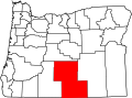
Map of Lake County
According to the United States Census Bureau, the county has a total area of 8,358 square miles (21,650km2), of which 8,139 square miles (21,080km2) is land and 219 square miles (570km2) (2.6%) is water.[16] It is the third-largest county in Oregon.
Lake County ranges in elevation from 4,130 to 8,446 feet (1,259 to 2,574m).[17] The highest point in Lake County is Crane Mountain. The mountain is located 6 miles (9.7km) north of the California border. Lake County has six other peaks with elevations above 8,000 feet (2,400m), all located in the southern half of the county. Hager Mountain is the highest peak in the northern part of the county.[18][19][20]
The area includes alkali lakes, high desert scrub, and forests of Western Juniper, Ponderosa Pine, and Lodgepole Pine in the hills and mountains. There are also several unusual geologic features and good areas for rockhounding and geological touring.
U.S. Decennial Census[34] 1790–1960[35] 1900–1990[36] 1990–2000[37] 2010–2020[1]
2020 census
Lake County, Oregon – Racial and ethnic composition Note: the US Census treats Hispanic/Latino as an ethnic category. This table excludes Latinos from the racial categories and assigns them to a separate category. Hispanics/Latinos may be of any race.
As of the 2010 census, there were 7,895 people, 3,378 households, and 2,148 families residing in the county.[47] The population density was 1.0 inhabitant per square mile (0.39/km2). There were 4,439 housing units at an average density of 0.5 per square mile (0.19/km2).[48] The racial makeup of the county was 90.3% white, 2.1% American Indian, 0.7% Asian, 0.5% black or African American, 0.1% Pacific islander, 3.1% from other races, and 3.3% from two or more races. Those of Hispanic or Latino origin made up 6.9% of the population.[47] In terms of ancestry, 27.9% were German, 19.3% were Irish, 19.2% were English, and 5.1% were American.[49]
Of the 3,378 households, 24.5% had children under the age of 18 living with them, 52.1% were married couples living together, 7.4% had a female householder with no husband present, 36.4% were non-families, and 31.3% of all households were made up of individuals. The average household size was 2.20 and the average family size was 2.73. The median age was 47.4 years.[47]
The median income for a household in the county was $41,105 and the median income for a family was $47,188. Males had a median income of $39,435 versus $26,000 for females. The per capita income for the county was $22,586. About 13.1% of families and 17.5% of the population were below the poverty line, including 27.4% of those under age 18 and 5.8% of those age 65 or over.[50]
2000 census
As of the 2000 census, there were 7,422 people, 3,084 households, and 2,152 families residing in the county. The population density was 1 personper square mile (0.39 person/km2). There were 3,999 housing units at an average density of 0 unitsper square mile (0/km2). The racial makeup of the county was 90.97% White, 0.13% Black or African American, 2.37% Native American, 0.71% Asian, 0.13% Pacific Islander, 3.19% from other races, and 2.48% from two or more races. 5.44% of the population were Hispanic or Latino of any race. 14.1% were of Irish, 14.0% United States or American, 13.8% German and 11.8% English ancestry. 95.9% spoke English and 3.6% Spanish as their first language.
There were 3,084 households, out of which 29.00% had children under the age of 18 living with them, 58.60% were married couples living together, 7.50% had a female householder with no husband present, and 30.20% were non-families. 26.20% of all households were made up of individuals, and 11.10% had someone living alone who was 65 years of age or older. The average household size was 2.39 and the average family size was 2.84.
In the county, the population was spread out, with 24.90% under the age of 18, 5.10% from 18 to 24, 24.30% from 25 to 44, 28.10% from 45 to 64, and 17.70% who were 65 years of age or older. The median age was 43 years. For every 100 females there were 100.50 males. For every 100 females age 18 and over, there were 98.30 males.
The median income for a household in the county was $29,506, and the median income for a family was $36,182. Males had a median income of $29,454 versus $23,475 for females. The per capita income for the county was $16,136. About 13.40% of families and 16.10% of the population were below the poverty line, including 20.40% of those under age 18 and 9.50% of those age 65 or over.
Though Lake County is located in central Oregon, politically it falls in line with the eastern side of the state. The majority of registered voters who are part of a political party in Lake County, as well as most counties in eastern Oregon, are members of the Republican Party. Since 2000, Republican nominees for president have always won over 70 percent of Lake County’s votes.[51] In the 2008 presidential election, 71.53% of Lake County voters voted for Republican John McCain, while 25.95% voted for DemocratBarack Obama and 1.53% of voters either voted for a Third Party candidate or wrote in a candidate.[52] These numbers show a small shift towards the Democratic candidate when compared to the 2004 presidential election, in which 77.8% of Lake County voters voted for George W. Bush, while 20.5% voted for John Kerry, and 1.7% of voters either voted for a Third Party candidate or wrote in a candidate.[53]
United States presidential election results for Lake County, Oregon[54]
The economy in Lake County is reliant on lumber, agriculture, natural resource extraction, health care, a prison[55] and government. The area is also trying to promote itself for the many outdoor recreational and sightseeing opportunities offered.[56]
Lake County includes numerous cattle ranches. Irrigation has also permitted some agriculture based upon the raising of livestock and the growing of hay and grain despite the low rainfall and a short growing season.
Lumber and wood products are taken from the Fremont National Forest, Bureau of Land Management properties and private landholdings. The Collins Companies operates the last remaining mill in the area, the Lakeview sawmill, and is also a large landowner in the region.[57] Over 78% of the land in Lake County is owned and managed by the federal and state government.[17]
The Lakeview area of Lake County also includes a perlite mine[58] and once included uranium mining, with processing to yellowcake being completed at the Lakeview Mining Company plant;[59] the mines and mill required remediation.[60] Several exploratory wells were dug for oil, but without success. [citation needed]
A railroad line ships timber products and perlite to Burlington Northern's rail hub in Alturas, California. At one time the railway was the only County owned and operated rail line in the country.[citation needed]
Government employment for the national forest and the regional Bureau of Land Management headquarters provides many of the higher salary jobs in an economy that otherwise would have to rely on seasonal agricultural, tourism and lumber jobs. The Bureau of Land Management is landowner of 49% of the lands within the county.
Lake County is home to the Lakeview Hospital, and other regional health care facilities. It's also the location for The Warner Creek Correctional Facility opened in 2005 and is a 400-bed minimum security state prison. The prison employs an average of 110 correctional professionals and is located on a site comprising 91 acres (370,000m2). The facility itself occupies less than 15 acres (61,000m2) and utilizes approximately 117,000sqft (10,900m2). of building space which includes areas for inmate housing, work and education programs, health services, food services, religious services, physical plant, warehouse and storage, vehicle maintenance, a laundry facility, recreational activities, administration and various other functions. A unique feature of the prison is its use of natural geothermal sources deep inside the Earth. The geothermally heated water is pumped up through a well and piped into a heat exchange unit where the heat is then transferred to the prison's water-loop system. Once the heat has been transferred and the water has cooled, the water is re-injected back into the ground.[62] Two prisoners briefly escaped in 2008.[63]
Arts and culture
Museums and other points of interest
North Lake County includes many geological sites including the Fort Rock, a crater marked by wave activity in what was once an ice age lake bed, and the Fort Rock Homestead Village Museum. It's also a site where camel bones and Native American artifacts have been uncovered. The "world's oldest shoes" were found here in 1938, changing the dates range scientists believed that humans inhabited the far west from 4,000 years ago.[64]
Several subsequent discoveries of even older sandals in the northern Great Basin confirmed the importance of archaeologist Luther Cressman's work. For this find, and for other research that broke down standing theories about the nature of the prehistoric Northwest, Cressman became known as the father of Oregon archaeology.[64] Other sights in North Lake include the Lost Forest, Crack-in-the-ground, and Hole-in-the-ground[65]
The Adel and Plush districts share students, with Plush taking the sum's Kindergarten through grade 3 students and Adel taking the sum's grades 4-8 students. For high school the districts send their students to Paisley and to Lakeview High School of the Lakeview district.[76]
↑ "Find a County". National Association of Counties. Retrieved June 7, 2011.
↑ McArthur, Lewis A. and Lewis L. McArthur, "Lake County", Oregon Geographic Names (Seventh Edition), Oregon Historical Society Press, Portland, Oregon, 2003, p. 553.
1 2 "Lakeview". Lakecountychamber.org. Archived from the original on January 19, 2007. Retrieved February 12, 2011.
↑ "Feature Detail Report for: Crane Mountain", Geologic Names Information System, United States Geological Survey, United States Department of the Interior, Reston, Virginia, November 27, 2014.
↑ "Feature Detail Report for: Hager Mountain", Geologic Names Information System, United States Geological Survey, United States Department of the Interior, Reston, Virginia, November 27, 2014.
↑ McArthur, Lewis A. and Lewis L. McArthur, "Warner Valley", Oregon Geographic Names (Seventh Edition), Oregon Historical Society Press, Portland, Oregon, 2003, p. 1010-1011.
↑ McArthur, Lewis A. and Lewis L. McArthur, "Glass Buttes", Oregon Geographic Names (Seventh Edition), Oregon Historical Society Press, Portland, Oregon, 2003, p. 404.
↑ "Rockhounding Site: Glass Butte", Deschutes National Forest, United States Forest Service, United States Department of Agriculture, Bend, Oregon, accessed November 19, 2016.
1 2 "Oregon's Tallest Town"Archived September 15, 2015, at the Wayback Machine (PDF), The Oregon Outback Scenic Byway, National Scenic Byway Driving Guide, Oregon Department of Transportation, Salem, Oregon, April 22, 2014.
This page is based on this Wikipedia article Text is available under the CC BY-SA 4.0 license; additional terms may apply. Images, videos and audio are available under their respective licenses.