
Boise is the capital and most populous city of the U.S. state of Idaho and is the county seat of Ada County. As of the 2020 census, there were 235,684 people residing in the city. On the Boise River in southwestern Idaho, it is 41 miles (66 km) east of the Oregon border and 110 miles (177 km) north of the Nevada border. The downtown area's elevation is 2,704 feet (824 m) above sea level.

Malheur County is one of the 36 counties in the U.S. state of Oregon. As of the 2020 census, the population was 31,571. Its county seat is Vale, and its largest city is Ontario. The county was named after the Malheur River, which runs through the county. The word "malheur" is French for misfortune or tragedy. Malheur County is included in the Ontario, Oregon Micropolitan Statistical Area, which is also included in the Boise Combined Statistical Area. It is included in the eight-county definition of Eastern Oregon.

Emmett is a city in Gem County, Idaho, United States. The population was 6,557 at the 2010 census, up from 5,490 in 2000. It is the county seat and the only city in the county. Emmett is part of the Boise−Nampa, Idaho Metropolitan Statistical Area.

The Boise–Nampa, Idaho Metropolitan Statistical Area (MSA) is an area that encompasses Ada, Boise, Canyon, Gem, and Owyhee counties in southwestern Idaho, anchored by the cities of Boise and Nampa. It is the main component of the wider Boise–Mountain Home–Ontario, ID–OR Combined Statistical Area, which adds Elmore and Payette counties in Idaho and Malheur County, Oregon. It is the state's largest officially designated metropolitan area and includes Idaho's three largest cities: Boise, Nampa, and Meridian. Nearly 40 percent of Idaho's total population lives in the area.

The Owyhee River is a tributary of the Snake River located in northern Nevada, southwestern Idaho and southeastern Oregon in the United States. It is 280 miles (450 km) long. The river's drainage basin is 11,049 square miles (28,620 km2) in area, one of the largest subbasins of the Columbia Basin. The mean annual discharge is 995 cubic feet per second (28.2 m3/s), with a maximum of 50,000 cu ft/s (1,400 m3/s) recorded in 1993 and a minimum of 42 cu ft/s (1.2 m3/s) in 1954.

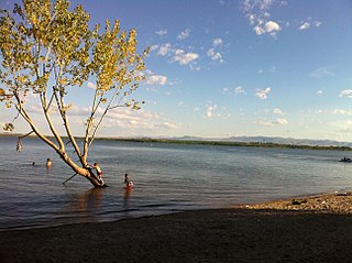
The Boise River is a 102-mile-long (164 km) tributary of the Snake River in the Northwestern United States. It drains a rugged portion of the Sawtooth Range in southwestern Idaho northeast of Boise, as well as part of the western Snake River Plain. The watershed encompasses approximately 4,100 square miles (11,000 km2) of highly diverse habitats, including alpine canyons, forest, rangeland, agricultural lands, and urban areas.

John Richard Simplot was an American entrepreneur and businessman best known as the founder of the J. R. Simplot Company, a Boise, Idaho-based agricultural supplier specializing in potato products. In 2007, he was estimated to be the 89th-richest person in the United States, at $3.6 billion. At the time of his death at age 99 in May 2008, he was the oldest billionaire on the Forbes 400.

The J. R. Simplot Company is an agribusiness company headquartered in Boise, Idaho.

The Payette River is an 82.7-mile-long (133.1 km) river in southwestern Idaho and is a major tributary of the Snake River.
The Deer Flat National Wildlife Refuge is an important breeding area for mammals, birds, and other animals. The National Wildlife Refuge is located on land surrounding Lake Lowell, just outside Nampa, Idaho. It serves as a resting and wintering area for birds, including mallards and Canada geese, along the Pacific Flyway and was named a "Globally Important Bird Area" by the American Bird Conservancy.

Southwestern Idaho is a geographical term for the area along the U.S. state of Idaho's borders with Oregon and Nevada. It includes the populous areas of the Boise metropolitan area and Treasure Valley.

The Snake River Valley AVA is an American Viticultural Area that encompasses an area in Southwestern Idaho and two counties in eastern Oregon. The Idaho Grape Growers and Wine Producers Commission and the Idaho Department of Commerce and Labor filed the petition to recognize the AVA, and it was granted in 2007.

Deadwood Reservoir is a reservoir in the western United States, in Valley County, Idaho. Located in the mountains of the Boise National Forest about 25 miles (40 km) southeast of Cascade, the 3,000-acre (12 km2) body on the Deadwood River is created by Deadwood Dam. The river flows south from the dam and is a tributary of the South Fork of the Payette River. The reservoir and vicinity is commonly used for camping, water skiing, fishing, canoeing, and other outdoor recreation. The full pool surface elevation is just above a mile-high at 5,334 ft (1,626 m) above sea level.

Owyhee Reservoir or Owyhee Lake is a reservoir on the Owyhee River in Malheur County, Oregon, United States. Located in far Eastern Oregon near the Idaho border, the reservoir is Oregon's longest at 52 miles (84 km). The 13,900-acre (56 km2) lake is home to several species of fish, including crappie, rainbow trout, largemouth bass, smallmouth bass, yellow perch, and brown bullhead. An artificial lake, it was created in 1932 with the completion of the Owyhee Dam. The lake supplies water for irrigation for 1,800 farms covering 118,000 acres of land in Eastern Oregon and Southwestern Idaho. Seasonal Lake Owyhee State Park is located on the northeast shore and includes a boat ramp.
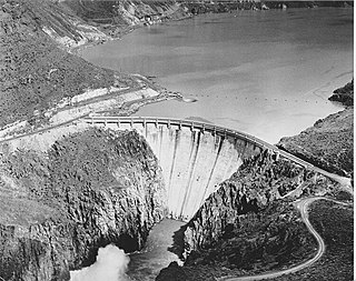
Owyhee Dam is a concrete arch-gravity dam on the Owyhee River in Eastern Oregon near Adrian, Oregon, United States. Completed in 1932 during the Great Depression, the dam generates electricity and provides irrigation water for several irrigation districts in Oregon and neighboring Idaho. At the time of completion, it was the tallest dam of its type in the world. The dam is part of the Owyhee Dam Historic District, which is listed on the National Register of Historic Places.

The Snake River Plain ecoregion is a Level III ecoregion designated by the United States Environmental Protection Agency (EPA) in the U.S. states of Idaho and Oregon. It follows the Snake River across Idaho, stretching roughly 400 miles (640 km) from the Wyoming border to Eastern Oregon in the xeric intermontane west. Characterized by plains and low hills, it is considerably lower and less rugged than surrounding ecoregions. Many of the alluvial valleys bordering the Snake River are used for agriculture. Where irrigation water and soil depth are sufficient, sugar beets, potatoes, alfalfa, small grains, and vegetables are grown. Elsewhere, livestock grazing is widespread. Cattle feedlots and dairy operations are found locally.

State Highway 21 (SH-21), also known as the Ponderosa Pine Scenic Byway, is a state highway in Idaho. It runs from Boise to Stanley, primarily as a two-lane road. With two-thirds of its length in Boise County, it passes by historic Idaho City and the village of Lowman to the western edge of the Sawtooth Mountains, then along their northern boundary to Stanley.

Smiths Ferry is a census-designated place in Valley County, Idaho, United States. Its population was 75 as of the 2010 census. Situated where the North Fork of the Payette River briefly calms and widens, its elevation is 4,554 feet (1,388 m) above sea level.
Deer Flat Upper Embankment is a dam in the western United States in southwestern Idaho. Located in the Treasure Valley in Canyon County, it is directly southwest of Nampa.


