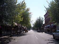
Roseburg is the most populous city in and the county seat of Douglas County, Oregon.[5] It is located in the Umpqua River Valley in southern Oregon. Founded in 1851, the population was 23,683 at the 2020 census, making it the principal city of the Roseburg, Oregon Micropolitan Statistical Area. The community developed along both sides of the South Umpqua River and is traversed by Interstate 5. Traditionally a lumber industry town, Roseburg is the home of Roseburg Forest Products, which now spans across 5 different states and 2 countries.
Waterfalls near Roseburg include Susan Creek Falls and Fall Creek Falls.[6] Roseburg's primary industries include timber and tourism, and the region is home to many vineyards and more than 30 wineries.[7]
The Oregon Department of Fish & Wildlife lists more than 50 areas for fishing for salmon, steelhead, bass, bluegill and trout in the Roseburg area.[8]
History
Modern-day Roseburg is located on the lands of numerous Indian tribes, including the Cow Creek Band of the Umpqua Tribe, whose Cow Creek Umpqua Indian Foundation is located in Roseburg.[9] Roseburg was the site of the 1855 Battle of Hungry Hill, part of the Rogue River Wars of 1855–56, fought between several southern Oregon Indian groups and the US Army.[10]
The city was named for settler Aaron Rose, who established a homestead within the current city limits on September 23, 1851.[11] Rose was born in 1813 in Ulster County, New York. In 1851, he came to Oregon from Coldwater, Michigan, where he had lived since 1837.[11]
Roseburg in 1891
Rose constructed the first building in what would become Roseburg, a rough structure made of poles and clapboards with a front room about 16 or 18 feet square; it was used as a grocery store, backed by a dining room and kitchen.[12] Originally, guests could use the floor of the front room to spread their beds or were able to sleep out of doors under nearby oak trees.[12] His first structure served as a roadside inn and tavern for many years. Rose built a proper hotel in 1853. He died in 1899.[11]
Roseburg was first known as Deer Creek because it was at the confluence of Deer Creek and the South Umpqua River.[11] In 1854, voters chose Roseburg as the county seat over rival town Winchester. Rose donated 3 acres (1.2ha) of land and $1,000 for the building of the county courthouse, and the important buildings of Winchester were moved to Roseburg before 1860.[11]
Deer Creek post office was established in 1852, and the name changed to "Roseburgh" in 1857. The spelling was changed to "Roseburg" in 1894.[11] Roseburg was incorporated by the Oregon Legislative Assembly on October 3, 1872.[13]
Timber Capital of the Nation
The fortunes of Roseburg grew with the lumber industry. In 1937, Roseburg Lumber opened. Founded by Kenneth Ford, the company became the major employer in the community. Other major employers, including Weyerhaeuser, Champion and Sun Studs also developed and grew during this time. By the 1970s Roseburg branded itself as the Timber Capital of the Nation.[citation needed]
Country singer Johnny Cash mythologized Roseburg loggers in the 1960 song "Lumberjack”:
"Ride this train to Roseburg, Oregon. Now there's a town for you! You talk about rough... You know a lot of places in the country claim Paul Bunyon lived there. But you should have seen Roseburg when me and my daddy come there. Every one of them loggers looked like Paul Bunyon to me.” [14]
Roseburg Blast
On August 7, 1959, at approximately 1:00a.m., the Gerretsen Building Supply Company caught fire. Firefighters soon arrived at the building, near Oak and Pine Streets, to extinguish the fire. Earlier in the evening, a truck driver for the Pacific Powder Company, George Rutherford, had parked his explosives truck in front of the building, which was not noticed. The truck exploded at around 1:14a.m., destroying buildings in an eight-block radius and severely damaging 30 more blocks.[15]
The truck was loaded with two tons of dynamite and four-and-a-half tons of the blasting agentnitrocarbonitrate. Rutherford had parked the truck after arranging his delivery for the following morning, despite warnings given to the Pacific Powder Company two days earlier not to leave such trucks unattended or park them in "congested areas". A police officer named Donald De Sues and the Chief of Police were on site and managed to evacuate citizens from the area of the truck before the explosion. Donald De Sues and the town Assistant Fire Chief, Roy McFarlane, were recognized as heroes that day and were both killed in the blast.[16][17] A total of fourteen people died in the blast and fire, and 125 were injured. Damage was estimated at 10 to 12 million dollars; the powder company was eventually made to pay $1.2million in civil damages, but was acquitted of criminal wrongdoing.[15]
Roseburg's downtown was rebuilt, primarily by businesses using money collected from insurance claims. The city built a new bridge over the South Umpqua River on parcels affected by the disaster.[15] Since the incident, it is commonly referred to as the Roseburg Blast or simply "The Blast". In 2005, SOPTV produced a documentary examining the Blast and the experiences of those who were involved or witnessed it, entitled The Roseburg Blast: A Catastrophe and Its Heroes.[18]
On October 1, 2015, students at Umpqua Community College near Roseburg were attacked by a 26-year-old gunman that had recently moved to the area from Southern California, who killed nine people (eight students and an assistant professor) and injured nine others. The gunman, a student at the school, committed suicide following a gun battle with police. This was the second school shooting in the Roseburg area, the other being a 2006 shooting at Roseburg High School. On October 9, President Barack Obama privately visited families of victims of the shooting. During his visit Obama stayed in multiple places, including an Inn and the Roseburg High School band teacher's room, because it was the safest place in the high school while he was giving speeches in the school's theater. Hundreds of local residents protested the visit due to Obama's support of gun control legislation.[19][20] In 1968, Bobby Kennedy had given a speech in Roseburg advocating for gun control for the mentally ill and for those with a "long criminal record" of murder.[21]
Geography
According to the United States Census Bureau, the city has a total area of 10.20 square miles (26.42km2), of which 10.01 square miles (25.93km2) is land and 0.19 square miles (0.49km2) is water.[22]
Roseburg's elevation is approximately 500 feet (150m). Its highest point is Mount Nebo, a 1,200-foot (370m) hill to the west of Interstate 5. Through the 1980s, it was known for its band of 10-20 feralangora goats. Residents said they could predict the weather by watching where the goats were on the mountain; if they were high, the weather would be good. If rain was pending, the goats moved to lower levels. Because the goats wandered across the freeway for grazing, they were a risk to traffic. In the 1980s, they were rounded up and placed for adoption.[23]
Climate
Roseburg has a Mediterranean climate (KöppenCsb borderline with Csa) with cool, rainy winters and very warm, dry summers. In a typical year, there are 30.9 days where the temperature reaches or exceeds 90°F or 32.2°C, and 2.7 days with a temperature of at least 100°F or 37.8°C. Conversely, the temperature drops to 32°F (0°C) or below 27.6 days a year.[24] The record high temperature is 114°F (45.6°C), set on June 27, 2021, and the record low temperature is −1°F (−18.3°C), set on January 22, 1962.[24]
In the summer, the area has little or no precipitation and plentiful sunshine — on average, 73.5percent of days in July, August and September are at least partly sunny.[24][25] There is also a much higher degree of diurnal temperature variation than in the winter. On the other hand, the majority of winter days are overcast[26] and rainy — during this period, rainfalls of 8 inches (200mm) per month are not uncommon, with as much as 15.74 inches (399.8mm) during the record wet month of December 1955. Roseburg averages 30.7 inches (779.8mm) of rain per year, more than half of which falls between November and January. The wettest "rain year" has been from July 1955 to June 1956 with 50.29 inches (1,277.4mm) and the driest from July 2000 to June 2001 with only 18.43 inches (468.1mm).
Light dustings of snow can sometimes be seen, but accumulations are rare. The most snowfall in a month is 23.4 inches (59cm) in January 1950.[27]
Climate data for Roseburg, Oregon (Roseburg Regional Airport), 1991–2020 normals, extremes 1900–present
Source: United States Census Bureau[28] U.S. Decennial Census[29] 2018 Estimate[30] [3]
2020 census
As of the 2020 census, Roseburg had a population of 23,683. The median age was 42.1 years. 19.9% of residents were under the age of 18 and 23.5% of residents were 65 years of age or older. For every 100 females there were 94.4 males, and for every 100 females age 18 and over there were 91.4 males age 18 and over.[31]
The 2020 census showed that 99.0% of residents lived in urban areas, while 1.0% lived in rural areas.[32]
There were 9,961 households in Roseburg, of which 24.3% had children under the age of 18 living in them. Of all households, 39.0% were married-couple households, 21.0% were households with a male householder and no spouse or partner present, and 31.4% were households with a female householder and no spouse or partner present. About 34.8% of all households were made up of individuals and 16.8% had someone living alone who was 65 years of age or older.[31]
There were 10,642 housing units, of which 6.4% were vacant. Among occupied housing units, 52.7% were owner-occupied and 47.3% were renter-occupied. The homeowner vacancy rate was 1.7% and the rental vacancy rate was 5.5%.[31]
As of the census of 2010, there were 21,181 people, 9,081 households, and 5,177 families residing in the city. The population density was 2,116.0 inhabitants per square mile (817.0/km2). There were 9,732 housing units at an average density of 972.2 per square mile (375.4/km2). The racial makeup of the city was 91% White, 0.5% African American, 1.7% Native American, 1.6% Asian, 0.3% Pacific Islander, 1.4% from other races, and 3.5% from two or more races. Hispanic or Latino of any race were 5.5% of the population.
There were 9,081 households, of which 27.0% had children under the age of 18 living with them, 39.2% were married couples living together, 13.2% had a female householder with no husband present, 4.6% had a male householder with no wife present, and 43.0% were non-families. 35.5% of all households were made up of individuals, and 16.8% had someone living alone who was 65 years of age or older. The average household size was 2.23 and the average family size was 2.84.
The median age in the city was 41.1 years. 21.7% of residents were under the age of 18; 9.1% were between the ages of 18 and 24; 23.8% were from 25 to 44; 26.2% were from 45 to 64; and 19.1% were 65 years of age or older. The gender makeup of the city was 48.0% male and 52.0% female.
2000 census
As of the census[4] of 2000, there were 20,017 people, 8,237 households, and 5,098 families residing in the city. The population density was 2,171.1 inhabitants per square mile (838.3/km2). There were 8,838 housing units at an average density of 958.6 per square mile (370.1/km2). The racial makeup of the city was 93.56% White, 0.3% African American, 1.3% Native American, 0.99% Asian, 0.1% Pacific Islander, 1.26% from other races, and 2.48% from two or more races. Hispanic or Latino of any race were 3.73% of the population.
There were 8,237 households, out of which 28.9% had children under the age of 18 living with them, 46.2% were married couples living together, 11.9% had a female householder with no husband present, and 38.1% were non-families. 31.6% of all households were made up of individuals, and 13.9% had someone living alone who was 65 years of age or older. The average household size was 2.32 and the average family size was 2.88.
In the city, the population was spread out, with 23.2% under the age of 18, 8.9% from 18 to 24, 26.5% from 25 to 44, 22.4% from 45 to 64, and 18.9% who were 65 years of age or older. The median age was 39 years. For every 100 females, there were 93.7 males. For every 100 females age 18 and over, there were 91.5 males.
The median income for a household in the city was $31,250, and the median income for a family was $40,172. Males had a median income of $32,624 versus $25,707 for females. The per capita income for the city was $17,082. About 11.0% of families and 15.1% of the population were below the poverty line, including 18.9% of those under age 18 and 9.2% of those age 65 or over.
In 2018, the City of Roseburg opened its own library. Previously, the city's library had been part of the Douglas County Library System but was closed when county libraries lost public funding.
Newspapers
There are three newspapers serving Roseburg. The News-Review is published one day per week and is based in Roseburg. The Roseburg Beacon is published weekly and serves Roseburg.[37] The Douglas County News is published weekly and is based in the nearby town of Sutherlin.
Roseburg and surrounding communities are regionally served by U-Trans (formerly Umpqua Transit), the local bus service.[38] In 2017, these services were significantly expanded.[39]
Greyhound Lines provide the community of Roseburg with more distant transportation.
12Riddle, George W. (1922). "Annual Address". Transactions of the Forty-Seventh Annual Reunion of the Oregon Pioneer Association June 19, 1919. Portland, OR: Chausse-Prudhomme Co. pp.165–166.
↑Baker, Frank C. (1891). "Special Laws". The Laws of Oregon, and the Resolutions and Memorials of the Sixteenth Regular Session of the Legislative Assembly Thereof. Salem, Oregon: State Printer: 888.
Stephen Dow Beckham, Land of the Umpqua: A History of Douglas County, Oregon. Roseburg, OR: Douglas County Commissioners, 1986.
J.V. Chenoweth, Douglas County's Golden Age. Oakland, OR: Oakland Printing Co., 1972.
Douglas County Historical Society, Historic Douglas County, Oregon, 1982. Roseburg, OR: Douglas County Historical Society, 1982.
Douglas County Museum, Land of Umpqua. Charleston, SC: Arcadia Publishing, 2011.
Diane L Goeres-Gardner, Roseburg. Charleston, SC: Arcadia Publishing, 2010.
R.J. Guyer, Douglas County Chronicles: History from the Land of One Hundred Valleys. Charleston, SC: The History Press, 2013.
Eli S. Hall, Then to Now with Roseburg Schools, 1854-1970. Portland, OR: Metropolitan Press, 1970.
Norman A. Myers and Gerald W. Williams, Letters to Home: Life in CCC Camps of Douglas County, Oregon, 1933-1934. Roseburg, OR: USDA-Forest Service, Umpqua National Forest, 1983.
Fred Reenstjerna and Jena Mitchell, Life in Douglas County, Oregon: The Western Experience. Roseburg, OR: Douglas County Museum, 1993.
William G. Robbins, The Far Western Frontier: Economic Opportunity and Social Democracy in Early Roseburg, Oregon. PhD dissertation. University of Oregon, 1969.
Norman Dennis Schlesser, Bastion of Empire: The Hudson Bay Company's Fort Umpqua, Being a Narrative of the Early Explorations and the Fur Trade in Douglas County. Oakland, OR: Oakland Printing Company, 1973.
Russell C. Youmans, Douglas County, Oregon: Structure of a Timber County Economy. Corvallis, OR: Agricultural Experiment Station, Oregon State University, 1973.
This page is based on this Wikipedia article Text is available under the CC BY-SA 4.0 license; additional terms may apply. Images, videos and audio are available under their respective licenses.