South Umpqua River

Last updated
South Umpqua River
South Umpqua River.jpg
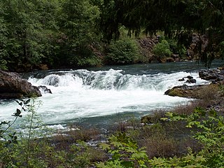
The South Umpqua near its confluence with the North Umpqua
USA Oregon location map.svg
Red pog.svg
Location of the mouth of the South Umpqua River in Oregon
EtymologyIndigenous people's name for the region near the river [1]
Location
Country United States
State Oregon
County Douglas
Physical characteristics
SourceConfluence of forks near Fish Mountain
 - locationNorthwest of Crater Lake, Cascade Range
 - coordinates 43°06′26″N122°35′22″W / 43.10722°N 122.58944°W / 43.10722; -122.58944 [2]
 - elevation2,009 ft (612 m) [3]
Mouth Confluence with North Umpqua River
 - location
Near Roseburg
 - coordinates
43°16′04″N123°26′46″W / 43.26778°N 123.44611°W / 43.26778; -123.44611 Coordinates: 43°16′04″N123°26′46″W / 43.26778°N 123.44611°W / 43.26778; -123.44611 [2]
 - elevation
361 ft (110 m) [2]
Length115 mi (185 km) [4]
Basin size1,800 sq mi (4,700 km2) [5]
Discharge 
 - locationnear Winston, about 20 miles (32 km) from the mouth [6]
 - average2,747 cu ft/s (77.8 m3/s) [6]
 - minimum16 cu ft/s (0.45 m3/s)
 - maximum125,000 cu ft/s (3,500 m3/s)

The South Umpqua River is a tributary of the Umpqua River, approximately 115 miles (185 km) long, in southwestern Oregon in the United States. [4] It drains part of the Cascade Range east of Roseburg. The river passes through a remote canyon in its upper reaches then emerges in the populated South Umpqua Valley east of Canyonville.

Umpqua River river in the United States of America

The Umpqua River on the Pacific coast of Oregon in the United States is approximately 111 miles (179 km) long. One of the principal rivers of the Oregon Coast and known for bass and shad, the river drains an expansive network of valleys in the mountains west of the Cascade Range and south of the Willamette Valley, from which it is separated by the Calapooya Mountains. From its source northeast of Roseburg, the Umpqua flows northwest through the Oregon Coast Range and empties into the Pacific at Winchester Bay. The river and its tributaries flow entirely within Douglas County, which encompasses most of the watershed of the river from the Cascades to the coast. The "Hundred Valleys of the Umpqua" form the heart of the timber industry of southern Oregon, generally centered on Roseburg.

Oregon State of the United States of America

Oregon is a state in the Pacific Northwest region on the West Coast of the United States. The Columbia River delineates much of Oregon's northern boundary with Washington, while the Snake River delineates much of its eastern boundary with Idaho. The parallel 42° north delineates the southern boundary with California and Nevada. Oregon is one of only three states of the contiguous United States to have a coastline on the Pacific Ocean.

United States federal republic in North America

The United States of America (USA), commonly known as the United States or America, is a country composed of 50 states, a federal district, five major self-governing territories, and various possessions. At 3.8 million square miles, the United States is the world's third or fourth largest country by total area and is slightly smaller than the entire continent of Europe's 3.9 million square miles. With a population of over 327 million people, the U.S. is the third most populous country. The capital is Washington, D.C., and the largest city by population is New York City. Forty-eight states and the capital's federal district are contiguous in North America between Canada and Mexico. The State of Alaska is in the northwest corner of North America, bordered by Canada to the east and across the Bering Strait from Russia to the west. The State of Hawaii is an archipelago in the mid-Pacific Ocean. The U.S. territories are scattered about the Pacific Ocean and the Caribbean Sea, stretching across nine official time zones. The extremely diverse geography, climate, and wildlife of the United States make it one of the world's 17 megadiverse countries.

Contents

Course

It rises in the high Cascades north of Fish Mountain, formed by the confluence of two short forks in eastern Douglas County approximately 20 miles (32 km) northwest of Crater Lake. It flows generally southwest through a remote canyon in the Umpqua National Forest to Tiller, then west past Milo and Days Creek. It emerges into the South Umpqua Valley at Canyonville, passing under Interstate 5 and flowing north along the highway past Tri-City, Myrtle Creek, and Roseburg. It joins the North Umpqua from the south to form the Umpqua approximately 6 miles (10 km) northwest of Roseburg.

Douglas County, Oregon county in Oregon, USA

Douglas County is a county in the U.S. state of Oregon. As of the 2010 census, the population was 107,667. The county seat is Roseburg. It is named after Stephen A. Douglas, an American politician who supported Oregon statehood.

Crater Lake caldera lake in south-central Oregon and main feature of Crater Lake National Park

Crater Lake is a crater lake in south-central Oregon in the western United States. It is the main feature of Crater Lake National Park and is famous for its deep blue color and water clarity. The lake partly fills a nearly 2,148-foot (655 m)-deep caldera that was formed around 7,700 years ago by the collapse of the volcano Mount Mazama. There are no rivers flowing into or out of the lake; the evaporation is compensated for by rain and snowfall at a rate such that the total amount of water is replaced every 250 years. With a depth of 1,949 feet (594 m), the lake is the deepest in the United States. In the world, it ranks ninth for maximum depth, and third for mean (average) depth.

Umpqua National Forest United States national forest in Oregon

Umpqua National Forest, in southern Oregon's Cascade Range, covers an area of 983,129 acres (3,978.58 km2) in Douglas, Lane, and Jackson counties, and borders Crater Lake National Park. The four ranger districts for the forest are the Cottage Grove, Diamond Lake, North Umpqua, and Tiller ranger districts. The forest is managed by the United States Forest Service, headquartered in Roseburg.

It receives Cow Creek from the south approximately 5 miles (8 km) southwest of Tri-City.

One of the main tributaries of the South Umpqua River is Cow Creek, which also flows west from the Cascade Mountains, but South of Canyonville. On its westward journey, the Cow Creek more or less runs parallel to the South Umpqua River, with an east–west mountain ridge separating them.

Cow Creek runs further west, swings around north and makes its confluence with the South Umpqua River at Tri City. The Cow Creek has such a significant flow that it is almost a toss-up as to which should be called the river and which the creek.

History

For centuries the South Umpqua River and Cow Creek were the homelands for the Umpqua Indians. However, gold was discovered on the South Umpqua River in 1848 causing an influx of gold miners and the homesteaders found the rich agricultural land of the area desirable.

In 1853 a treaty was negotiated between Joel Palmer, Superintendent of Indians, representing the Government of the United States and Chief Quintioosan and others, representing the Cow Creek Band of the Umpqua people. [7] Although the US Government ratified the treaty, the terms agreed upon in the treaty were never honored.

Joel Palmer trailblazing pioneer, guidebook author, U.S. politician

General Joel Palmer was an American pioneer of the Oregon Territory in the Pacific Northwest region of North America. He was born in Canada, and spent his early years in New York and Pennsylvania before serving as a member of the Indiana House of Representatives.

The Cow Creek Band of Umpqua Tribe of Indians, known to the Bureau of Indian Affairs (BIA) as the Cow Creek Band of Umpqua Indians of Oregon is a federally recognized Native American tribal government based in Canyonville, Oregon, United States. The Cow Creek Band is also known as the Upper Umpqua. The tribe takes its name from Cow Creek, a tributary of the South Umpqua River.

Umpqua people

The Umpqua are any of several distinct groups of Native Americans that live in present-day south central Oregon in the United States.

Beginning in the 1820s, trappers and traders of the Hudson's Bay Company began using the South Umpqua River valley to move along what became known as the Siskiyou Trail. The Siskiyou Trail was based on existing Indian footpaths, and became an important link between the Pacific Northwest and California's Central Valley.

Hudsons Bay Company Canadian retail business group

The Hudson's Bay Company is a Canadian retail business group. A fur trading business for much of its existence, HBC now owns and operates retail stores in Canada, the United States, and parts of Europe including Belgium, the Netherlands, and Germany. The company's namesake business division is Hudson's Bay, commonly referred to as The Bay. Other divisions include Galeria Kaufhof, Home Outfitters, Lord & Taylor and Saks Fifth Avenue. HBC's head office is currently located in Brampton, Ontario. The company is listed on the Toronto Stock Exchange under the symbol "HBC".

Siskiyou Trail

The Siskiyou Trail stretched from California's Central Valley to Oregon's Willamette Valley; modern-day Interstate 5 follows this pioneer path. Originally based on existing Native American foot trails winding their way through river valleys, the Siskiyou Trail provided the shortest practical travel path between early settlements in California and Oregon.

In 1846, spurred by the desire to create a safer trail for emigrants to use to reach the Willamette Valley, Jesse and Lindsay Applegate, Levi Scott, and 13 other companions explored a new route through the valley that connected the southern Willamette Valley with Goose Lake in Northern California. This trail became known as the Applegate Trail, and linked up with the northernmost branch of the California Trail.

Jesse Applegate American pioneer

Jesse Applegate was an American pioneer who led a large group of settlers along the Oregon Trail to the Oregon Country. He was an influential member of the early government of Oregon, and helped establish the Applegate Trail as an alternative route to the Oregon Trail.

Lindsay Applegate trailblazing pioneer, U.S. politician

Lindsay Applegate was a pioneer known for his participation in blazing the Applegate Trail, an alternative route of the Oregon Trail. The trail was blazed with his brothers Charles and Jesse in 1846. Charles Applegate was not a member of the party that blazed the Applegate Trail from the Willamette Valley to the Humboldt River. According to an original manuscript written by Lindsay Applegate in 1877, the members of the expedition were: Capt. Levi Scott, John Scott, Henry Boygus, Lindsay Applegate, Jesse Applegate, Benjamin Burch, John Owens, John Jones, Robert Smith, Samuel Goodhue, Moses "Black" Harris, David Goff, Benit Osburn, William Sportsman, and William Parker.

Levi C. Scott (1797–1890) was a politician in the Oregon Territory of the United States in the 1850s. A native of Illinois, he was a captain during the Cayuse War, helped lay the Applegate Trail, served in the Oregon Territorial Legislature, and in 1857 was a member of the Oregon Constitutional Convention. Scott also founded Scottsburg, Oregon, and is the namesake for several natural features in Southern Oregon.

Interstate 5 closely follows the original Siskiyou Trail route through the valley today.

Economic importance

The South Umpqua River valley became an important timber-producing region in the 20th century. In the 21st century, tourism became important to the South Umpqua Valley.

The Cow Creek Band of the Umpqua Tribe of Indians received a land claims settlement from the US federal government in 1988.

Using the land claims settlement of $1.5 million, the Cow Creek Band operates a casino, hotel, convention center, and other businesses in Canyonville on the South Umpqua River.

South Umpqua Falls near Tiller is the site of a popular picnic area and United States Forest Service campground near the river. Open from May 1 to October 31, the campground has 16 sites suitable for tents or trailers. [8]

See also

Related Research Articles

Jackson County, Oregon county in Oregon, USA

Jackson County is a county in the U.S. state of Oregon. As of the 2010 census, the population was 203,206. The county seat is Medford. The county is named for Andrew Jackson, the seventh president of the United States.

North Umpqua River tributary of the Umpqua River in the USA

The North Umpqua River is a tributary of the Umpqua River, about 106 miles (171 km) long, in southwestern Oregon in the United States. It drains a scenic and rugged area of the Cascade Range southeast of Eugene, flowing through steep canyons and surrounded by large Douglas-fir forests. Renowned for its emerald green waters, it is considered one of the best fly fishing streams in the Pacific Northwest for anadromous fish.

Little River (North Umpqua River tributary) tributary of the North Umpqua River in Oregon, United States of America

The Little River is a tributary of the North Umpqua River, about 30 miles (48 km) long, in southwestern Oregon in the United States. It drains part of the western side of the Cascade Range east of Roseburg, between the North and South Umpqua.

Calapooya Mountains mountain range

The Calapooya Mountains are a mountain range in Lane and Douglas counties of southwestern Oregon in the United States. The range runs for approximately 60 miles (97 km) west from the Cascade Range between Eugene on the north and Roseburg on the south.

Applegate Trail emigrant trail in the western United States

The Applegate Trail was an emigrant trail through the present-day U.S. states of Idaho, Nevada, California, and Oregon used in the mid-19th century by emigrants on the American frontier. It was originally intended as a less dangerous alternative to the Oregon Trail by which to reach the Oregon Territory. Much of the route was coterminous with the California Trail.

Confederated Tribes of the Grand Ronde Community of Oregon

The Confederated Tribes of the Grand Ronde Community of Oregon (CTGR) consists of twenty-seven Native American tribes with long historical ties to present-day western Oregon between the western boundary of the Oregon Coast and the eastern boundary of the Cascade Range, and the northern boundary of southwestern Washington and the southern boundary of northern California. The community has an 11,288-acre (46 km2) Indian reservation, the Grand Ronde Indian Reservation, which was established in 1855 in Yamhill and Polk counties.

Oregon Route 227 highway in Oregon

Oregon Route 227 is an Oregon state highway which formerly ran from the city of Canyonville, Oregon to the community of Trail. In 2003, the highway was truncated at the Douglas-Jackson County line, with only the southern section remaining under state control. It is known as the Tiller-Trail Highway No. 230.

Southern Oregon AVA

The Southern Oregon AVA, is an American Viticultural Area which lies in Southern Oregon, United States. The Southern Oregon AVA was established in 2004, and was created to include the land of two smaller AVAs, the Rogue Valley AVA and the Umpqua Valley AVA. Southern Oregon AVA was established to allow the two principal winegrowing regions in the southern part of the state to market themselves jointly. This creation of a "super-AVA" is a departure from the trend in the Willamette Valley AVA or northern Oregon of establishing smaller AVAs specific to a particular locale's climate or soil conditions.

Interstate 5 (I-5) in the U.S. state of Oregon is a major Interstate Highway that traverses the state from north to south. It travels to the west of the Cascade Mountains, connecting Portland to Salem, Eugene, Medford, and other major cities in the Willamette Valley and across the northern Siskiyou Mountains. The highway runs 308 miles (496 km) from the California state line near Ashland to the Washington state line in northern Portland, forming the central part of Interstate 5's route between Mexico and Canada.

Seven Feathers Casino Resort

Seven Feathers Casino Resort is a 298-room, AAA three-star hotel and casino located in Canyonville, Oregon, United States. The casino is owned by the Cow Creek Band of Umpqua Tribe of Indians. At 232,500 square feet (21,600 m2), with 68,000 square feet (6,300 m2) of gaming space, it is the largest facility of its kind in Southern Oregon. The resort attracts over one million visitors annually.

Tiller Ranger Station

The Tiller Ranger Station is a United States Forest Service compound consisting of twenty-seven buildings in Oregon’s Umpqua National Forest. Over the years, it has been the administrative headquarters for five ranger districts. It is located in the small unincorporated community of Tiller, Oregon, United States. The historic structures were built in the rustic style by the Civilian Conservation Corps between 1935 and 1942. Today, the ranger station is the headquarters for the Tiller Ranger District, and is listed on the National Register of Historic Places.

Cow Creek (South Umpqua River)

Cow Creek is a medium-sized river in southwestern Oregon, a tributary of the South Umpqua River. It drains an area of over 400 square miles (1,000 km2) on the western foothills of the Cascade Range and within the Oregon Coast Range. Although the vast majority of the basin is within Douglas County, a tiny portion in the southeast extends into northern Jackson County.

Campbell Falls is a waterfall from the South Fork of the Umpqua River east of Canyonville, Oregon, some 12 miles upstream from Tiller, which is 25 miles east of Interstate 5 between Roseburg and Grants Pass. The waterfall is known for being the start point for river rafting the South Umpqua River and is the centerpiece attraction of the Boulder Creek Campground.

References

  1. McArthur, p. 982
  2. 1 2 3 "South Umpqua River". Geographic Names Information System. United States Geological Survey. November 28, 1980. Retrieved January 11, 2011.
  3. Source elevation derived from Google Earth search using GNIS source coordinates.
  4. 1 2 "River Steward Program: Umpqua River (South)". Native Fish Society. 2011. Retrieved January 12, 2011.
  5. "South Umpqua – 17100302: 8-Digit Hydrologic Unit Profile" (PDF). National Resources Conservation Service, United States Department of Agriculture. May 2006. Retrieved January 12, 2011.
  6. 1 2 "Water-data report 2009: 14312000 South Umpqua River near Brockway, OR" (PDF). United States Geological Survey. Retrieved January 12, 2011.
  7. "Treaty with the UmpquaCow Creek Band, 1853" (PDF). U.S. Fish and Wildlife Service. Retrieved January 12, 2011.
  8. "South Umpqua Falls Campground". U.S. Forest Service. July 29, 2010. Retrieved January 12, 2011.

Works cited