Sutherlin, Oregon

Last updated

Sutherlin, Oregon
Sutherlin Bank Building - Sutherlin Oregon.jpg
The historic Sutherlin Bank Building (built 1910), located at 101 West Central Avenue in Sutherlin
Nickname: 
City of Flags
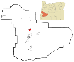
Douglas County Oregon Incorporated and Unincorporated areas Sutherlin Highlighted.svg
Location in Oregon
Coordinates: 43°23′18″N123°19′20″W / 43.38833°N 123.32222°W / 43.38833; -123.32222
Country United States
State Oregon
County Douglas
Incorporated 1911
Government
   Mayor Todd McKnight
Area
[1]
  Total6.19 sq mi (16.04 km2)
  Land6.11 sq mi (15.83 km2)
  Water0.08 sq mi (0.21 km2)
Elevation
[2]
525 ft (160 m)
Population
 (2020) [3]
  Total8,524
  Density1,394.86/sq mi (538.53/km2)
Time zone UTC-8 (Pacific)
  Summer (DST) UTC-7 (Pacific)
ZIP code
97479
Area code 541
FIPS code 41-71650 [4]
GNIS feature ID2412018 [2]
Website www.ci.sutherlin.or.us

Sutherlin is a city in Douglas County, Oregon, United States. As of the 2010 Census, the population was 7,810, making it the second most populous city in Douglas County. Located just off of Interstate 5, nearby features include Cooper Creek Reservoir, Ford's Pond (treated wastewater), the Umpqua River, a golf course, and numerous vineyards.

Contents

Sutherlin High School Sutherlin High School (Sutherlin, Oregon).jpg
Sutherlin High School

The City of Sutherlin Police Department also serves the City of Oakland via a paid contract. [5]

Geography and climate

Sutherlin is located at 43°23′18″N123°18′58″W / 43.38833°N 123.31611°W / 43.38833; -123.31611 (43.388435, -123.316175). [6]

According to the United States Census Bureau, the city has a total area of 6.35 square miles (16.45 km2), of which 6.15 square miles (15.93 km2) is land and 0.20 square miles (0.52 km2) is water. [7]

Sutherlin has the typical western Oregon Mediterranean climate (Köppen: Csb), characterized by dry summers featuring cool mornings and hot afternoons, and chilly, wet winters.

Climate data for Sutherlin, OR
MonthJanFebMarAprMayJunJulAugSepOctNovDecYear
Mean daily maximum °F (°C)49
(9)
53
(12)
58
(14)
62
(17)
69
(21)
75
(24)
83
(28)
84
(29)
78
(26)
67
(19)
53
(12)
47
(8)
65
(18)
Mean daily minimum °F (°C)36
(2)
36
(2)
38
(3)
41
(5)
46
(8)
51
(11)
55
(13)
54
(12)
49
(9)
43
(6)
40
(4)
36
(2)
44
(6)
Average precipitation inches (mm)5.57
(141)
4.39
(112)
4.20
(107)
3.25
(83)
2.28
(58)
1.21
(31)
0.40
(10)
0.49
(12)
1.20
(30)
2.92
(74)
6.01
(153)
6.80
(173)
38.72
(984)
Source: [8]

Demographics

Historical population
CensusPop.Note
1920 515
1930 457−11.3%
1940 52514.9%
1950 2,230324.8%
1960 2,45210.0%
1970 3,07025.2%
1980 4,56048.5%
1990 5,02010.1%
2000 6,66832.8%
2010 7,81017.1%
2020 8,5249.1%
2021 (est.)8,593 [9] 0.8%
U.S. Decennial Census [10] [3]

2010 census

As of the census of 2010, there were 7,810 people, 3,249 households, and 2,178 families living in the city. The population density was 1,269.9 inhabitants per square mile (490.3/km2). There were 3,566 housing units at an average density of 579.8 per square mile (223.9/km2). The racial makeup of the city was 92.4% White, 0.2% African American, 1.9% Native American, 0.6% Asian, 0.1% Pacific Islander, 1.8% from other races, and 2.9% from two or more races. Hispanic or Latino of any race were 6.1% of the population. [4]

There were 3,249 households, of which 27.3% had children under the age of 18 living with them, 51.6% were married couples living together, 11.4% had a female householder with no husband present, 4.1% had a male householder with no wife present, and 33.0% were non-families. 27.3% of all households were made up of individuals, and 14.8% had someone living alone who was 65 years of age or older. The average household size was 2.37 and the average family size was 2.86. [4]

The median age in the city was 44.8 years. 22.4% of residents were under the age of 18; 6.6% were between the ages of 18 and 24; 21.2% were from 25 to 44; 25.7% were from 45 to 64; and 24% were 65 years of age or older. The gender makeup of the city was 47.6% male and 52.4% female. [4]

2000 census

As of the census of 2000, there were 6,669 people, 2,713 households, and 1,909 families living in the city. The population density was 1,283.2 inhabitants per square mile (495.4/km2). There were 2,975 housing units at an average density of 572.4 per square mile (221.0/km2). The racial makeup of the city was 93.79% White, 0.13% African American, 1.72% Native American, 0.51% Asian, 0.06% Pacific Islander, 1.09% from other races, and 2.68% from two or more races. Hispanic or Latino of any race were 3.97% of the population. [4]

There were 2,713 households, out of which 30.0% had children under the age of 18 living with them, 56.7% were married couples living together, 9.8% had a female householder with no husband present, and 29.6% were non-families. 24.5% of all households were made up of individuals, and 14.5% had someone living alone who was 65 years of age or older. The average household size was 2.46 and the average family size was 2.88. [4]

In the city, the population was spread out, with 25.0% under the age of 18, 6.7% from 18 to 24, 24.9% from 25 to 44, 22.0% from 45 to 64, and 21.3% who were 65 years of age or older. The median age was 40 years. For every 100 females, there were 91.5 males. For every 100 females age 18 and over, there were 86.9 males. [4]

The median income for a household in the city was $29,068, and the median income for a family was $34,414. Males had a median income of $32,047 versus $20,911 for females. The per capita income for the city was $13,439. About 12.4% of families and 14.9% of the population were below the poverty line, including 16.5% of those under age 18 and 9.1% of those age 65 or over. [4]

Related Research Articles

<span class="mw-page-title-main">Pacific County, Washington</span> County in Washington, United States

Pacific County is a county in the U.S. state of Washington. As of the 2020 census, the population was 23,365. Its county seat is South Bend, and its largest city is Raymond. The county was formed by the government of Oregon Territory in February 1851 and is named for the Pacific Ocean.

<span class="mw-page-title-main">Douglas County, Oregon</span> County in Oregon, United States

Douglas County is one of the 36 counties in the U.S. state of Oregon. As of the 2020 census, the population was 111,201. The county seat is Roseburg. The county is named after Stephen A. Douglas, an American politician who supported Oregon statehood. Douglas County comprises the Roseburg, OR Micropolitan Statistical Area. In regards to area, Douglas County is the largest county west of the Oregon Cascades.

Upper Kalskag is a city in Bethel Census Area, Alaska, United States. It is thirty miles west of Aniak. At the 2010 census the population was 210, down from 230 in 2000.

<span class="mw-page-title-main">Islandia, Florida</span> Unincorporated community in Florida, United States

Islandia is an unincorporated community and former city in Miami-Dade County, Florida, United States. It is located in the upper Florida Keys on the islands of Elliott Key and other nearby keys, such as Totten Key. It was the only municipality in the Florida Keys not located in neighboring Monroe County. The population was 18 at the 2010 Census. Most residents of the city were National Park Service employees.

<span class="mw-page-title-main">Irwin, Idaho</span> City in Idaho, United States

Irwin is a city in Bonneville County, Idaho, United States. It is part of the Idaho Falls, Idaho Metropolitan Statistical Area. The population was 259 at the 2020 census, and 219 at the 2010 census.

<span class="mw-page-title-main">Imlay Township, Michigan</span> Civil township in Michigan, United States

Imlay Township is a civil township of Lapeer County in the U.S. state of Michigan. The population was 3,115 at the 2020 Census.

<span class="mw-page-title-main">Loraine, North Dakota</span> City in North Dakota, United States

Loraine is a city in Renville County, North Dakota, United States. The population was 9 at the 2020 census. It is part of the Minot Micropolitan Statistical Area.

<span class="mw-page-title-main">Richland, Oregon</span> City in Oregon, United States

Richland is a city in Baker County, Oregon, United States. The population was 156 at the 2010 census.

<span class="mw-page-title-main">Unity, Oregon</span> City in Oregon, United States

Unity is a city in Baker County, Oregon, United States, located in the Burnt River Valley. The population was 71 at the 2010 census.

<span class="mw-page-title-main">Oak Grove, Oregon</span> Unincorporated community in the state of Oregon, United States

Oak Grove is an unincorporated community in Clackamas County, Oregon, United States, in the Portland metropolitan area. For statistical purposes, the United States Census Bureau has defined Oak Grove as a census-designated place (CDP). The census definition of the area may not precisely correspond to local understanding of the area with the same name. The population was 16,629 at the 2010 census.

<span class="mw-page-title-main">Dunes City, Oregon</span> City in Oregon, United States

Dunes City is a city in Lane County, Oregon, United States. The population was 1,303 at the 2010 census.

<span class="mw-page-title-main">Harrisburg, Oregon</span> City in Oregon, United States

Harrisburg is a city in Linn County, Oregon, United States. The population was 3,567 at the 2010 census.

<span class="mw-page-title-main">Mehama, Oregon</span> Unincorporated community in the state of Oregon, United States

Mehama is an unincorporated community in Marion County, Oregon, United States, located on Oregon Route 22 and the North Santiam River. For statistical purposes, the United States Census Bureau has defined Mehama as a census-designated place (CDP). The census definition of the area may not precisely correspond to local understanding of the area with the same name. The population was 317 at the 2020 census. It is part of the Salem Metropolitan Statistical Area.

<span class="mw-page-title-main">Independence, Oregon</span> City in Oregon, United States

Independence is a city in Polk County, Oregon, United States, on the west bank of the Willamette River along Oregon Route 51, and east of nearby Monmouth. It is part of the Salem Metropolitan Statistical Area. Thirty square blocks of the oldest part of Independence form the National Register of Historic Places-listed Independence Historic District.

<span class="mw-page-title-main">Mosier, Oregon</span> City in Oregon, United States

Mosier is a city along the Columbia River in Wasco County, Oregon, United States. The population was 433 at the 2010 census.

<span class="mw-page-title-main">Banks, Oregon</span> City in Oregon, United States

Banks is a city in Washington County, Oregon, United States, which is located in the Tualatin Valley. It is the southern anchor to the Banks–Vernonia State Trail, which is a 21-mile-long (34 km) linear trail popular with bicyclists, hikers, and equestrians. The population was 1,777 at the 2010 census. The community was named for John and Nancy Banks, who owned a nearby dairy farm. Incorporated in 1921, it is located in the western part of the county where Oregon Route 6 intersects Oregon Route 47.

<span class="mw-page-title-main">Pymatuning Central, Pennsylvania</span> Census-designated place in Pennsylvania, United States

Pymatuning Central is a census-designated place (CDP) in Crawford County, Pennsylvania, United States. The population was 2,269 at the 2010 census.

<span class="mw-page-title-main">Sherwood, Wisconsin</span> Village in Wisconsin, United States

Sherwood is a village in Calumet County, Wisconsin, United States. The population was 2,713 at the 2010 census. The former historical unincorporated community of High Cliff is located within present-day Sherwood.

<span class="mw-page-title-main">Mount Sterling, Wisconsin</span> Village in Wisconsin, United States

Mount Sterling is a village in Crawford County, Wisconsin, United States. The population was 211 at the 2010 census.

<span class="mw-page-title-main">Fox Lake (town), Wisconsin</span> Town in Wisconsin, United States

Fox Lake is a town in Dodge County, Wisconsin, United States. The population was 2,402 at the 2000 census. The City of Fox Lake is located within the town. The unincorporated communities of Delbern Acres, Fox Lake Junction, and Lyndon Dale are also located in the town.

References

  1. "ArcGIS REST Services Directory". United States Census Bureau. Retrieved October 12, 2022.
  2. 1 2 U.S. Geological Survey Geographic Names Information System: Sutherlin, Oregon
  3. 1 2 "Census Population API". United States Census Bureau. Retrieved October 12, 2022.
  4. 1 2 3 4 5 6 7 8 "U.S. Census website". United States Census Bureau . Retrieved December 21, 2012.
  5. Bain, Dan (December 10, 2008). "Sutherlin agrees on policing deal". KPIC.com. Retrieved October 4, 2015.
  6. "US Gazetteer files: 2010, 2000, and 1990". United States Census Bureau. February 12, 2011. Retrieved April 23, 2011.
  7. "US Gazetteer files 2010". United States Census Bureau. Archived from the original on January 25, 2012. Retrieved December 21, 2012.
  8. "Monthly Averages for Sutherlin, OR (97479)". The Weather Channel. Retrieved March 16, 2012.
  9. "Population and Housing Unit Estimates". United States Census Bureau. May 28, 2022. Retrieved May 28, 2022.
  10. "Census of Population and Housing". Census.gov. Retrieved June 4, 2015.

Further reading