Green, Oregon

Last updated
Green, Oregon
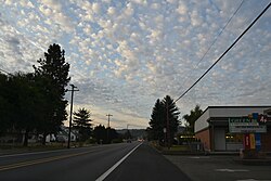
Green, Oregon.jpg
Douglas County Oregon Incorporated and Unincorporated areas Green Highlighted.svg
Location of Green, Oregon
Coordinates: 43°9′37″N123°22′4″W / 43.16028°N 123.36778°W / 43.16028; -123.36778 Coordinates: 43°9′37″N123°22′4″W / 43.16028°N 123.36778°W / 43.16028; -123.36778
Country United States
State Oregon
County Douglas
Area
[1]
  Total4.69 sq mi (12.16 km2)
  Land4.55 sq mi (11.80 km2)
  Water0.14 sq mi (0.36 km2)
Elevation
515 ft (157 m)
Population
 (2020) [2]
  Total7,614
  Density1,671.57/sq mi (645.38/km2)
Time zone UTC-8 (Pacific (PST))
  Summer (DST) UTC-7 (PDT)
FIPS code 41-30750 [3]
GNIS feature ID1166660 [4]

Green is a census-designated place (CDP) and unincorporated community in Douglas County, Oregon, United States. [5] The population was 7,614 at the 2020 census. [6]

Contents

Education

Green has two public elementary schools, Green Elementary and Sunnyslope Elementary.

As of 2020, 89.3% of the adult population, aged 25 and above, were high school graduates, and 15.1% had a bachelor's degree.

Geography

Green is located 515 feet (157 m) above sea-level. [5]

According to the United States Census Bureau, the CDP has a total area of 4.7 square miles (12 km2), of which 4.6 square miles (12 km2) is land and 0.2 square miles (0.52 km2), or 3.61%, is water.

Demographics

Prior to 1970, the United States census did not include specific population data for Green CDP. Until 1980, Green was included in the "Looking Glass division."

Historical population
CensusPop.
1970 1,612
1980 3,897141.7%
1990 5,07630.3%
2000 6,17421.6%
2010 7,51521.7%
2020 7,6141.3%
U.S. Decennial Census [7] [2]

2020

In 2020, Green had 3,106 households, with an average of 2.61 persons per household. 83.3% had been living in the same home one year ago. The median household income was $57,737, and the per capita income $25,109. 13.3% of the population were below the poverty line.

19.3% of the population were aged 17 or under, and 16.9% were over the age of 65. Females were 49.5% of the population. 9.89% of the adult population were veterans.

6.2% of people spoke a language other than English at home, and 3.3% were foreign born. The racial distribution of the CDP was 93.8% white (88.3% Non-Hispanic white), 0.4% African American, 0.6% Native American, 0.2% Asian, and 0% Hawaiian or Pacific Islander. 3.4% identified as two or more races, and 7.7% as Hispanic or Latino.

2000

As of the census [3] of 2000, there were 6,174 people, 2,197 households, and 1,718 families residing in the CDP. The population density was 1,358.1 people per square mile (523.9/km2). There were 2,350 housing units at an average density of 516.9/sq mi (199.4/km2). The racial makeup of the CDP was 93.94% White, 0.16% African American, 1.20% Native American, 0.50% Asian, 0.13% Pacific Islander, 1.57% from other races, and 2.49% from two or more races. Hispanic or Latino people of any race were 4.41% of the population.

There were 2,197 households, out of which 39.5% had children under the age of 18 living with them, 59.7% were married couples living together, 13.5% had a female householder with no husband present, and 21.8% were non-families. 17.9% of all households were made up of individuals, and 6.4% had someone living alone who was 65 years of age or older. The average household size was 2.79 and the average family size was 3.08.

In the CDP, the population was spread out, with 30.3% under the age of 18, 8.1% from 18 to 24, 30.2% from 25 to 44, 20.9% from 45 to 64, and 10.5% who were 65 years of age or older. The median age was 33 years. For every 100 females, there were 93.1 males. For every 100 females age 18 and over, there were 90.6 males.

The median income for a household in the CDP was $35,660, and the median income for a family was $40,400. Males had a median income of $31,582 versus $21,984 for females. The per capita income for the CDP was $15,208. About 10.2% of families and 12.0% of the population were below the poverty line, including 15.9% of those under age 18 and 12.9% of those age 65 or over.
Related Research Articles

<span class="mw-page-title-main">Meridianville, Alabama</span> Census-designated place in Alabama, United States

Meridianville is an unincorporated community and census-designated place (CDP) in Madison County, Alabama, United States, and is included in the Huntsville-Decatur Combined Statistical Area. As of the 2020 census, the population of the CDP was 8,209.

<span class="mw-page-title-main">Salem, Saline County, Arkansas</span> CDP in Arkansas, United States

Salem is a census-designated place (CDP) in Saline County, Arkansas, United States. Per the 2020 census, the population was 2,544. It is part of the Little Rock–North Little Rock–Conway Metropolitan Statistical Area.

<span class="mw-page-title-main">Riverdale, California</span> Census-designated place in California, United States

Riverdale is a census-designated place (CDP) in Fresno County, California, United States. The population was 3,153 at the 2010 census, up from 2,416 at the 2000 census. Riverdale is located 23 miles (37 km) south of Fresno, at an elevation of 223 ft (68 m).

<span class="mw-page-title-main">Alondra Park, California</span> Census designated place in California, United States

Alondra Park, also known as El Camino Village, is a census designated place (CDP) in Los Angeles County, California, United States. It is the unincorporated area north of Alondra Community Regional Park and El Camino College. It is east of Lawndale, south of Hawthorne, west of Gardena, and north of Torrance. Manhattan Beach Boulevard and Crenshaw Boulevard are the two major cross streets in the area. The population was 8,569 at the 2020 census, down from 8,592 at the 2010 census. There is an official Alondra Park Post Office of the U.S. Postal Service in nearby Gardena, California. Urbanized cement-lined Dominguez Creek bisects a portion of Alondra Park.

<span class="mw-page-title-main">Progress Village, Florida</span> Census-designated place in Florida, United States

Progress Village is a census-designated place (CDP) in Hillsborough County, Florida, United States. Per the 2020 census, the population was 11,188.

<span class="mw-page-title-main">Whitmore Village, Hawaii</span> Census-designated place in Hawaii, United States

Whitmore Village is a census-designated place (CDP) in Honolulu County, Hawaiʻi, United States. The population was 4,887 at the 2020 census.

<span class="mw-page-title-main">Green Valley, Maryland</span> Census-designated place in Maryland

Green Valley is an unincorporated area and census-designated place (CDP) in southern Frederick County, Maryland, United States. The population was 12,643 at the 2020 census. The area was listed as a census-designated place in 2000 but not listed as part of any CDP at the 2010 census. It was re-designated a census-designated place for the 2020 census.

<span class="mw-page-title-main">White Meadow Lake, New Jersey</span> Census-designated place in New Jersey, United States

White Meadow Lake is an unincorporated community and census-designated place (CDP) located within Rockaway Township, in Morris County, New Jersey, United States. As of the 2010 United States Census, the CDP's population was 8,836.

<span class="mw-page-title-main">Twin Lakes, New Mexico</span> CDP in New Mexico, United States

Twin Lakes is a census-designated place (CDP) in McKinley County, New Mexico, United States. The population was 1,069 at the 2000 census.

<span class="mw-page-title-main">Bellerose Terrace, New York</span> Hamlet and census-designated place in New York, United States

Bellerose Terrace is a hamlet and census-designated place (CDP) in the Town of Hempstead in Nassau County, on Long Island, in New York, United States. The population was 2,329 at the 2020 census.

<span class="mw-page-title-main">Jennings Lodge, Oregon</span> Unincorporated community in the state of Oregon, United States

Jennings Lodge is a census-designated place and unincorporated community in Clackamas County, Oregon, United States, between Milwaukie and Gladstone. For statistical purposes, the United States Census Bureau has defined Jennings Lodge as a census-designated place (CDP). The census definition of the area may not precisely correspond to local understanding of the area with the same name. As of the United States Census, 2010, it had a total population of 7,315.

<span class="mw-page-title-main">Village Green-Green Ridge, Pennsylvania</span> Census-designated place in Pennsylvania, United States

Village Green-Green Ridge is a census-designated place (CDP) in Delaware County, Pennsylvania, United States. The population was 7,822 at the 2010 census, down from 8,279 at the 2000 census.

<span class="mw-page-title-main">Valley Green, Pennsylvania</span> CDP in Pennsylvania, United States

Valley Green is a census-designated place (CDP) in York County, Pennsylvania, United States. The population was 3,429 at the 2010 census.

<span class="mw-page-title-main">Green Valley, South Dakota</span> CDP in South Dakota, United States

Green Valley is a census-designated place (CDP) and unincorporated community in Pennington County, South Dakota, United States. The population was 1,051 at the 2020 census.

<span class="mw-page-title-main">Circle D-KC Estates, Texas</span> CDP in Texas, United States

Circle D-KC Estates is a census-designated place (CDP) in Bastrop County, Texas, United States. The population was 2,588 at the 2020 census.

<span class="mw-page-title-main">Wyldwood, Texas</span> CDP in Texas, United States

Wyldwood is a census-designated place (CDP) in Bastrop County, Texas, United States. The population was 3,694 at the 2020 census.

<span class="mw-page-title-main">Scenic Oaks, Texas</span> Census-designated place in Texas, United States

Scenic Oaks is a census-designated place (CDP) in Bexar County, Texas, United States. It is part of the San Antonio Metropolitan Statistical Area. The population was 10,458 at the 2010 census, up from 4,957 at the 2010 census.

<span class="mw-page-title-main">Green Valley Farms, Texas</span> Census-designated place in Texas, United States

Green Valley Farms is a census-designated place (CDP) in Cameron County, Texas, United States. The population was 1,272 at the 2010 census, up from 720 at the 2000 census. It is part of the Brownsville–Harlingen Metropolitan Statistical Area.

<span class="mw-page-title-main">Canutillo, Texas</span> Census-designated place in Texas, United States

Canutillo is a census-designated place (CDP) in El Paso County, Texas, United States. The population was 6,321 at the 2010 census. It is part of the El Paso Metropolitan Statistical Area. The ZIP Codes encompassing the CDP area are 79835 and 79932.

<span class="mw-page-title-main">Escobares, Texas</span> City in Texas, United States

Escobares is a city in Starr County, Texas, United States. The population was 2,588 at the 2020 census. The city was formed in 2005 from part of the deleted Escobares CDP, and parts of Garceno, and North Escobares CDPs, and additional area. Prior to its 2005 incorporation as a city, it was a census-designated place (CDP). The population of the CDP was 1,954 at the 2000 census.

References

  1. "ArcGIS REST Services Directory". United States Census Bureau. Retrieved October 12, 2022.
  2. 1 2 "Census Population API". United States Census Bureau. Retrieved Oct 12, 2022.
  3. 1 2 "U.S. Census website". United States Census Bureau . Retrieved 2022-05-31.
  4. "US Board on Geographic Names". United States Geological Survey. 2007-10-25. Retrieved 2008-01-31.
  5. 1 2 "Green". Geographic Names Information System . United States Geological Survey, United States Department of the Interior. 1980-11-28. Retrieved 2010-01-09.
  6. "Profile of General Population and Housing Characteristics: 2020 Demographic Profile Data (DP-1): Green CDP, Oregon". United States Census Bureau . Retrieved May 31, 2022.
  7. "Census of Population and Housing". Census.gov. Retrieved June 4, 2015.