
Oxbow is an unincorporated community in Baker County, Oregon, United States. Oxbow is along Oregon Route 86 next to the Snake River near the Oxbow Dam on the Oregon-Idaho border, about 17 miles (27 km) northeast of Halfway. Oxbow is just south of the site of the former mining town of Copperfield. Oxbow has a post office with a ZIP code 97840.
Beatty is an unincorporated community and census-designated place (CDP) in Klamath County, Oregon, United States. Beatty is along Oregon Route 140 at the confluence of the Sycan and Sprague rivers and is 40 miles (64 km) by highway northeast of Klamath Falls.

Camp Sherman is an unincorporated community and census-designated place (CDP) in Jefferson County, Oregon, United States. It is located on the Metolius River. The year-round population as of the 2010 census was 233, with that number tripling or more during the summer. The community includes an elementary school, Black Butte School, a general store and a post office. The community also has a volunteer fire department. Camp Sherman was founded by vacationers from Sherman County in the latter part of the 19th century.

Cascadia is an unincorporated community and census-designated place (CDP) that was established in 1892 on the South Santiam River, 14 miles (23 km) east of the current city of Sweet Home, in Linn County, Oregon, United States. As of the 2010 census it had a population of 147.

Hartsel is an unincorporated town, a post office, and a census-designated place (CDP) located in and governed by Park County, Colorado, United States. The Hartsel post office has the ZIP Code 80449. At the United States Census 2010, the population of the 80449 ZIP Code Tabulation Area was 909 including adjacent areas. The CDP is a part of the Denver–Aurora–Lakewood, CO Metropolitan Statistical Area.

Asti is an unincorporated community in Sonoma County, California, United States. It is located near U.S. Route 101 in the Alexander Valley between Cloverdale, Geyserville and Healdsburg, and was named after the city in northern Italy.

Buxton is an unincorporated community in Washington County, Oregon, United States, near Oregon Route 47.

Blodgett is a census-designated place (CDP) and unincorporated community in Benton County, Oregon, United States, where Oregon Route 180 meets U.S. Route 20 in the Central Oregon Coast Range 15 miles (24 km) west of Corvallis. It is near the confluence of the Tumtum and Marys rivers. As of the 2010 census, the community had a population of 58.

Post is an unincorporated community in Crook County, Oregon, United States. It has a post office assigned the ZIP code of 97752. Post lies along Oregon Route 380 southeast of Prineville at an elevation of 3,383 feet (1,031 m). Post was named for Walter H. Post, the first postmaster of the Post post office, established in 1889.
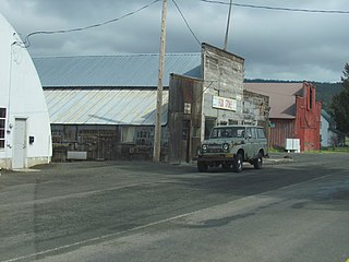
Mikkalo is an unincorporated community in Gilliam County, Oregon, United States, at an elevation of 1,470 feet (450 m). Mikkalo is about 4 miles (6.4 km) northwest of Clem. Mikkalo has a post office, serving ZIP code of 97861, and is in the 541 area code region. In 1905, the place was named for settler John Mikkalo, and a post office opened at Mikkalo in 1907. It was along the Condon Branch of the Union Pacific Railroad. The Mikkalo Farmers Elevator had a fire on March 28, 1921.
Bates is an unincorporated community in Grant County, Oregon, United States. it has a post office with a ZIP code 97817. The elevation is 4,062 feet (1,238 m).
Fox is an unincorporated community in Grant County, Oregon, United States, on U.S. Route 395 south of Long Creek.

Trail is a census-designated place and unincorporated community in Jackson County, Oregon, United States. As of the 2010 census it had a population of 702. It has a post office with a ZIP code of 97541.

Saginaw is an unincorporated community in Lane County, Oregon, United States. Saginaw had a post office with a ZIP code 97472 until the market it operated in was closed. Saginaw lies at the intersection of Oregon Route 99 and Saginaw Road, just west of the Saginaw exit of Interstate 5. Saginaw is northeast of Cottage Grove.

Kent is an unincorporated community in Sherman County, Oregon, United States. Kent has a post office with a ZIP code 97033. Kent lies at the intersection of U.S. Route 97 and Dobie Point Road, between Grass Valley to the north and Shaniko to the south.

Curtin is an unincorporated community in Douglas County, Oregon, United States. It is on Interstate 5 and the former Southern Pacific railroad line about 7 miles (11 km) northeast of Drain along Pass Creek. It stands at an elevation of 404 feet.
Dillard is an unincorporated community and census-designated place in Douglas County, Oregon, United States. Dillard is south of the city of Winston. Dillard has a post office with ZIP code 97432. As of the 2010 census, it had a population of 478.
Broadbent is an unincorporated community in Coos County, Oregon, United States. Broadbent is on Oregon Route 542 south of Myrtle Point along the South Fork Coquille River. Broadbent has a post office with ZIP code 97414.
Crescent is an unincorporated community in Klamath County, Oregon, United States. Crescent is along U.S. Route 97 about 47 miles (76 km) south-southwest of Bend. Crescent has a post office with ZIP code 97733.

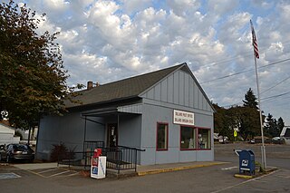
Birkenfeld is an unincorporated community in Columbia County, Oregon, United States, in the Nehalem Valley on Oregon Route 202 between Jewell and Mist.


