
Douglas County is one of the 36 counties in the U.S. state of Oregon. As of the 2020 census, the population was 111,201. The county seat is Roseburg. The county is named after Stephen A. Douglas, an American politician who supported Oregon statehood. Douglas County comprises the Roseburg, OR Micropolitan Statistical Area.
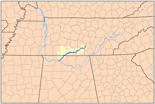
The Elk River is a tributary of the Tennessee River in the U.S. states of Tennessee and Alabama. The river is about 195 miles (314 km) long.
The Park Range, elevation approximately 3,712 metres (12,178 ft), is a mountain range in the Rocky Mountains of northwestern Colorado in the United States. The range forms a relatively isolated part of the Continental Divide, extending north-to-south for approximately 170 kilometres (110 mi) along the boundary between Jackson (east) and Routt counties. It separates North Park in the upper basin of the North Platte River on the east from the Elk River basin in the watershed of the Yampa River the west. It rises steeply out of the Yampa River basin, forming a climatic barrier that receives much snowfall in winter. The northern end of the range lies in Wyoming and is known as the Sierra Madre Range.
Bruner is an unincorporated community in northeast Christian County, Missouri, United States. It is located approximately five miles east of Sparta and two miles west of Elkhead along Route 14. Bruner is part of the Springfield, Missouri Metropolitan Statistical Area.
Elkhead is an unincorporated community in eastern Christian County, Missouri, United States. It is located on Route 14, approximately sixteen miles east of Ozark. Elkhead formerly had a post office with a ZIP code 65643, but mail is now served by the post office in Sparta.

Missouri Mountain is a high mountain summit in the Collegiate Peaks of the Sawatch Range of the Rocky Mountains of North America. The 14,074-foot (4,290 m) fourteener is located in the Collegiate Peaks Wilderness of San Isabel National Forest, 15.2 miles (24.5 km) northwest by west of the Town of Buena Vista in Chaffee County, Colorado, United States. Missouri Mountain is separated from its eastern neighbor Mount Belford by Elkhead Pass.
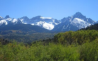
The Southern Rocky Mountains are a major subregion of the Rocky Mountains of North America located in the southeastern portion of the U.S. state of Wyoming, the central and western portions of Colorado, the northern portion of New Mexico, and extreme eastern portions of Utah. The Southern Rocky Mountains are also commonly known as the Southern Rockies, and since the highest peaks are located in the State of Colorado, they are sometimes known as the Colorado Rockies, although many important ranges and peaks rise in the other three states. The Southern Rockies include the highest mountain ranges of the Rocky Mountains and include all 30 of the highest major peaks of the Rockies.
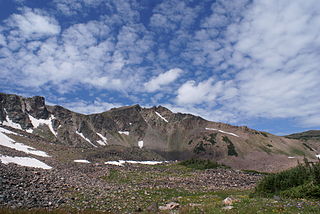
The Elkhead Mountains are a mountain range in Colorado. The mountain range is considered to be low altitude within Colorado as all of the peaks are under 11,000 feet (3,400 m). Located within Routt and Moffat counties, the Elkhead Mountains are far from metropolitan areas and have few lakes and streams, so they attract relatively few visitors.

The Crawford House is a building in Steamboat Springs, Colorado, USA, that is listed on the National Register of Historic Places for its importance as the primary residence for 36 years of James Harvey Crawford, the Father of Steamboat Springs, and his wife, Margaret Emerine (Bourn) Crawford, the Mother of Routt County. The two of them together were among the most influential pioneering families in northwest Colorado. The Crawford House is also listed as a rare local example of residential Romanesque Revival architecture.
Black Mountain is a prominent mountain summit in the Elkhead Mountains range of the Rocky Mountains of North America. The 10,865-foot (3,312 m) peak is located in Routt National Forest, 20.9 miles (33.6 km) north-northeast of the City of Craig in Moffat County, Colorado, United States. Black Mountain is the highest point in Moffat County.
Columbus Mountain, elevation 10,253 ft (3,125 m), is a summit in the Elkhead Mountains of northern Colorado, United States. The mountain is northwest of Steamboat Springs in the Routt National Forest.

Elkhead Reservoir State Park is a Colorado state park located in Moffat and Routt counties in northwest Colorado, near Craig. The park surrounds and includes the 900 surface acre Elkhead Reservoir. It is referred to as Elkhead State Park. Elkhead Reservoir State Park is managed as a complex out of the Yampa River State Park office, located to the west of the town of Hayden, CO.
The Elkhead Limestone is a geologic formation in Idaho. It preserves fossils dating back to the Cambrian period.

State Route 50 (SR 50) is a west–to–east highway in Middle Tennessee. The road begins near Only and ends in Altamont. The current length is 161.3 miles (259.6 km).
Elkhead Reservoir is located in northwest Colorado near the town of Craig. It was originally constructed by the Division of Wildlife on the Elkhead Creek, which is a major tributary of the Yampa River. A 205 square miles (530 km2) river basin drains into the reservoir. It has a capacity of 25,550 acre-feet (0.03152 km3). The dam was enlarged for two years ending in 2006. This enlargement cost $31 million and raised the height of the dam by 25 feet (7.6 m) and of the pool by 20 feet (6.1 m). The reservoir is found at an elevation of 6,355 feet (1,937 m).

Elk Creek is a tributary, about 46 miles (74 km) long, of the Umpqua River in the U.S. state of Oregon. The creek begins near Ben More Mountain in the lower Cascade Range south of Elkhead and flows generally north until passing under Interstate 5 in Scotts Valley. It then turns sharply west, flowing through the small city of Drain before meeting the Umpqua at Elkton. Oregon Route 99 runs along the creek for a short distance south of Drain, and Oregon Route 38 follows the creek from Drain to Elkton.

Elk Mountain is a summit in Routt County, Colorado. The mountain lies to the northwest of Steamboat Springs and is easily seen from the city, especially from along Lincoln Avenue, Steamboat's main street. The mountain is also easily seen from Mount Werner, the home of the Steamboat Ski Resort.


