Gardiner, Oregon

Last updated

Gardiner Historic District
Gardiner Historic District (Gardiner, Oregon).jpg
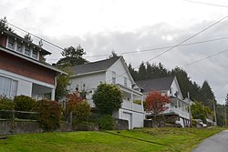
The Gardiner Historic District in 2011.
Gardiner HD boundary map.png
The Gardiner Historic District boundaries.
LocationGardiner, Oregon, roughly bounded by 3rd, Camp, 2nd, Pitt, Spring, Front and Garden Streets [1]
Nearest city Reedsport, Oregon
Coordinates 43°43′49″N124°06′36″W / 43.730278°N 124.11°W / 43.730278; -124.11
Area35 acres (14 ha) [1]
Built1870–1940 [1]
NRHP reference No. 93000003
Added to NRHPJanuary 31, 1994 [2]

Gardiner is an unincorporated community and census-designated place in Douglas County, Oregon, United States, across the Umpqua River from Reedsport. It is located on U.S. Route 101. As of the 2010 census, it had a population of 248. [3]

Contents

Gardiner is named for a Boston merchant whose ship, the Bostonian, shipwrecked at the mouth of the Umpqua on October 1, 1850. [4] Gardiner was seeking to trade along the river, and most of his goods were saved from the ship and moved to the location that came to be the town of Gardiner. [4] In 1851, the site became the headquarters of the Umpqua customs district, and a post office named "Gardiners City" was established the same year. [4] The name of the post office changed to "Gardiner City" and eventually to its current name.

The Gardiner Historic District, which encompasses nearly all of Gardiner, [1] has been listed on the National Register of Historic Places since 1994. [2] Several steamboats were constructed at Gardiner for trade up the Umpqua River.

Outside the remnants of the International Paper mill in Gardiner, Oregon. Remnants of the Gardiner Mill.JPG
Outside the remnants of the International Paper mill in Gardiner, Oregon.

A plywood plant opened in Gardiner in 1954, joining the lumber mill (or sawmill) that had been in the town for many years.[ citation needed ]

Gardiner was formerly the site of the first International Paper mill on the West Coast. [5] The paper mill operated from 1963 until 1999, and was one of the largest employers on the southern Oregon Coast. [6] The mill buildings were demolished in 2006. [6] [7]

A railroad, the Longview, Portland & Northern (LP&N), served the IP mill until it closed. [8] The railroad runs from East Gardiner Junction to the old plant site.

Climate

This region experiences warm (but not hot) and dry summers, with no average monthly temperatures above 71.6 °F (22.0 °C). According to the Köppen Climate Classification system, Gardiner has a warm-summer Mediterranean climate, abbreviated "Csb" on climate maps. [9]

Climate data for Gardiner
MonthJanFebMarAprMayJunJulAugSepOctNovDecYear
Record high °F (°C)67
(19)
78
(26)
76
(24)
86
(30)
94
(34)
95
(35)
93
(34)
104
(40)
95
(35)
95
(35)
70
(21)
67
(19)
104
(40)
Average high °F (°C)52.9
(11.6)
54.5
(12.5)
56.5
(13.6)
58.5
(14.7)
62.1
(16.7)
65.1
(18.4)
68.7
(20.4)
69.3
(20.7)
69.2
(20.7)
64.4
(18.0)
56.5
(13.6)
51.3
(10.7)
60.7
(15.9)
Average low °F (°C)39.3
(4.1)
39.9
(4.4)
40.8
(4.9)
42.7
(5.9)
46
(8)
49.6
(9.8)
51.6
(10.9)
52.1
(11.2)
49
(9)
46
(8)
42.7
(5.9)
37.8
(3.2)
44.8
(7.1)
Record low °F (°C)22
(−6)
14
(−10)
18
(−8)
27
(−3)
31
(−1)
23
(−5)
40
(4)
40
(4)
34
(1)
30
(−1)
24
(−4)
9
(−13)
9
(−13)
Average precipitation inches (mm)10.3
(260)
8.57
(218)
8.47
(215)
4.84
(123)
3.82
(97)
2.47
(63)
0.64
(16)
0.75
(19)
1.59
(40)
4.65
(118)
12.26
(311)
10.74
(273)
69.09
(1,755)
Average snowfall inches (cm)0
(0)
0
(0)
0
(0)
0
(0)
0
(0)
0
(0)
0
(0)
0
(0)
0
(0)
0
(0)
0
(0)
0.1
(0.25)
0.1
(0.25)
Average precipitation days211719161310556122220166
Source: [10]

Notable people

USPS Post Office - Gardiner, Oregon 97441 Gardiner Post Office.jpg
USPS Post Office - Gardiner, Oregon 97441

See also

Related Research Articles

<span class="mw-page-title-main">Oregon City, Oregon</span> City in Oregon, United States

Oregon City is the county seat of Clackamas County, Oregon, United States, located on the Willamette River near the southern limits of the Portland metropolitan area. As of the 2020 census, the city population was 37,572. Established in 1829 by the Hudson's Bay Company, in 1844 it became the first U.S. city west of the Rocky Mountains to be incorporated.

<span class="mw-page-title-main">Douglas County, Oregon</span> County in Oregon, United States

Douglas County is one of the 36 counties in the U.S. state of Oregon. As of the 2020 census, the population was 111,201. The county seat is Roseburg. The county is named after Stephen A. Douglas, an American politician who supported Oregon statehood. Douglas County comprises the Roseburg, OR Micropolitan Statistical Area. In regards to area, Douglas County is the largest county west of the Oregon Cascades.

<span class="mw-page-title-main">Elkton, Oregon</span> City in Oregon, United States

Elkton is a city in Douglas County, Oregon, United States. It is located on the lower Umpqua River, at the junction of Oregon Route 38 and Oregon Route 138, about 20 miles (32 km) west of Interstate 5 and about 14 miles (23 km) west of Drain. The population was 195 at the 2010 census, an increase from 147 people in 2000.

<span class="mw-page-title-main">Myrtle Creek, Oregon</span> City in Oregon, United States

Myrtle Creek is a city in Douglas County, Oregon, United States. The population was 3,439 at the 2010 census.

<span class="mw-page-title-main">Reedsport, Oregon</span> City in Oregon, United States

Reedsport is a city in northwest Douglas County, Oregon, United States. As of the 2020 census, the population was 4,310.

<span class="mw-page-title-main">Longview, Washington</span> City in Washington, United States

Longview is a city in Cowlitz County, Washington, United States. It is the principal city of the Longview, Washington Metropolitan Statistical Area, which encompasses all of Cowlitz County. Longview's population was 37,818 at the time of the 2020 census, making it the largest city in Cowlitz County. The city is located in southwestern Washington, at the junction of the Cowlitz and Columbia rivers. Longview shares a border with Kelso to the east, which is the county seat.

<span class="mw-page-title-main">Calapooya Mountains</span> Mountain range in Oregon, United States

The Calapooya Mountains are a mountain range in Lane and Douglas counties of southwestern Oregon in the United States. The range runs for approximately 60 miles (97 km) west from the Cascade Range between Eugene on the north and Roseburg on the south.

<span class="mw-page-title-main">Noti, Oregon</span> Unincorporated community in the state of Oregon, United States

Noti is an unincorporated community in Lane County, Oregon, United States, located in the foothills of the Central Oregon Coast Range between Eugene and Florence. Per the 2000 census, Noti had a total population of 699.

<span class="mw-page-title-main">Prospect, Oregon</span> Unincorporated community in the state of Oregon, United States

Prospect is an unincorporated community and census-designated place (CDP) in Jackson County, in the U.S. state of Oregon. It lies along Oregon Route 62 on the Rogue River, in the Rogue River – Siskiyou National Forest. As of the 2010 census it had a population of 455.

<span class="mw-page-title-main">Longview, Portland and Northern Railway</span> Former American short-line railroad

The Longview, Portland and Northern Railway is a historic railroad operation in the U.S. states of Oregon and Washington. It was founded by timber baron Robert A. Long, the founder of Longview, Washington. The company was incorporated in 1922.

<span class="mw-page-title-main">Days Creek, Oregon</span> Unincorporated community in the state of Oregon, United States

Days Creek is an unincorporated community and census-designated place in Douglas County, Oregon, United States. At the 2010 census it had a population of 272.

<span class="mw-page-title-main">Winchester, Oregon</span> Unincorporated community in the state of Oregon, United States

Winchester is an unincorporated community in Douglas County, Oregon, United States. It is on the south bank of the North Umpqua River 4 miles (6.4 km) north of Roseburg on Interstate 5 and is included in the Roseburg North CDP for statistical purposes.

<span class="mw-page-title-main">Steamboats of the Oregon Coast</span>

The history of steamboats on the Oregon Coast begins in the late 19th century. Before the development of modern road and rail networks, transportation on the coast of Oregon was largely water-borne. This article focuses on inland steamboats and similar craft operating in, from south to north on the coast: Rogue River, Coquille River, Coos Bay, Umpqua River, Siuslaw Bay, Yaquina Bay, Siletz River, and Tillamook Bay. The boats were all very small, nothing like the big sternwheelers and propeller boats that ran on the Columbia River or Puget Sound. There were many of them, however, and they came to be known as the "mosquito fleet."

Shedd is an unincorporated community and census-designated place (CDP) in Linn County, Oregon, United States, on Oregon Route 99E. As of the 2010 census it had a population of 204.

<span class="mw-page-title-main">Lookingglass, Oregon</span> Unincorporated community in the state of Oregon, United States

Lookingglass is an unincorporated community and census-designated place in the Lookingglass Valley of Douglas County, Oregon, United States, about 9 miles (14 km) southwest of Roseburg. As of the 2010 census it had a population of 855. Lookingglass is considered a suburb of Roseburg.

<i>Washington</i> (steamboat 1851)

Washington was an early steamboat operated in the states of California and Oregon. Washington was built in California and was initially operated on the Sacramento River. In 1851, the steamer was purchased and brought on a ship to the Oregon Territory, where it was operated on the Willamette River until the summer of 1853. Washington was sold again, and then transferred to the Oregon coast, where it operated on the Umpqua River, on the Coquille River and on Coos Bay. Washington was able to operate for shorter distances over the open ocean along the Oregon coast. The steamer was wrecked by a boiler explosion in December 1857, near Scottsburg, O.T., on the Umpqua river.

<span class="mw-page-title-main">Milo, Oregon</span> Unincorporated community in the state of Oregon, United States

Milo is an unincorporated community in Douglas County, Oregon, United States, about 17 miles (27 km) east of Canyonville on the South Umpqua River.

<span class="mw-page-title-main">Vaughn, Oregon</span> Human settlement in Oregon, United States

Vaughn is an unincorporated community in Lane County, Oregon, United States. It is located about 4 miles (6.4 km) south of Noti in the foothills of the Central Oregon Coast Range near Noti Creek. Author Ralph Friedman described Vaughn as "a mill in the meadows".

<i>Eva</i> (sternwheeler)

Eva was a sternwheel steamboat that was operated on the Umpqua River on the Oregon coast in the early part of the 1900s. Eva was notable for long service on a short route of about 20 miles. Eva was also notable for having been used by one of its owners to illegally transport dynamite on a passenger-carrying vessel, by the ruse of labeling the dynamite boxes as "bacon."

<i>Unio</i> (sternwheeler)

Unio was a small sternwheel-driven steamboat which operated on the Willamette and Yamhill rivers from 1861 to 1869. This vessel is primarily remembered for its having been named Unio when built in 1861, in the first year of the American Civil War, and then having the name completed, to Union, by a new, staunchly pro-Union owner, James D. Miller. Union appears to have sunk in 1869, been salvaged, and then dismantled, with the machinery going to a new steamer then being built for service on the Umpqua River.

References

  1. 1 2 3 4 Young, Ella Mae (December 10, 1993), National Register of Historic Places Registration Form: Gardiner Historic District (PDF), retrieved April 1, 2013.
  2. 1 2 Oregon Parks and Recreation Department, Oregon Historic Sites Database , retrieved April 2, 2013.
  3. "Profile of General Population and Housing Characteristics: 2010 Demographic Profile Data (DP-1): Gardiner CDP, Oregon". United States Census Bureau . Retrieved February 10, 2012.
  4. 1 2 3 McArthur, Lewis A.; Lewis L. McArthur (2003) [1928]. Oregon Geographic Names (Seventh ed.). Portland, Oregon: Oregon Historical Society Press. p. 392. ISBN   0-87595-277-1.
  5. "Paper Making Timeline". International Paper . Retrieved August 29, 2007.
  6. 1 2 Chambers, Susan (May 6, 2006). "Eight seconds and it's over". Corvallis Gazette-Times . Retrieved August 29, 2007.
  7. Ross, Winston (May 7, 2006). "Boom! Crash! A longtime mill is imploded, marking the end of an era". Sunday Register-Guard. (Eugene, Oregon). p. A1.
  8. Gardiner Division—History of the Longview, Portland & Northern spur line that served the IP plant, from Abandoned Railroads of the Pacific Northwest
  9. Climate Summary for Gardiner, Oregon
  10. "GARDINER 1 N, OR (353193)". Western Regional Climate Center. Retrieved November 23, 2015.