Oregon Geographic Names

Last updated
Oregon Geographic Names
Oregon Geographic Names (7th Edition).jpg
Cover of 7th edition
Author Lewis A. McArthur and Lewis L. McArthur (editors)
Subject Oregon place names
Publisher Oregon Historical Society
Publication date
1928 (1st edition); 2003 (7th edition)
Pages1073 pp. (7th edition)
ISBN 978-0-87595-278-9
OCLC 636774573
979.5/003
LC Class F874.M16 2003
LCCN   2003-20467

Oregon Geographic Names is a compilation of the origin and meaning of place names in the U.S. state of Oregon, published by the Oregon Historical Society. The book was originally published in 1928. It was compiled and edited by Lewis A. McArthur. As of 2011, the book is in its seventh edition, which was compiled and edited by Lewis L. McArthur [lower-alpha 1] (who died in 2018).

Contents

Content

In its introduction, it identifies six periods in the history of the state which have contributed to the establishment of local names:

The seventh edition contains 6,252 entries, with references to another 2,679 names scattered throughout the text. [1] Entries are listed in alphabetical order, beginning with A B Crossing, a railroad station in Coos County, [2] and ending with Zwagg Island , an island near Brookings, Oregon. [3]

Edition history

The first three editions were edited by Lewis A. McArthur and published by Binford & Mort; [4] Lewis L. McArthur took over from his father as of the fourth (1974) edition, [5] which was the first to be published by the Oregon Historical Society Press. [6]

The seventh edition also includes a CD-ROM with a complete biographic and geographic index as well as various maps of Oregon locations. [7]

YearEditionEditorPublisherPages
ISBN Example barcode.svg
ISBN
Library of Congress
Control Number
19281stMcArthur, Lewis A.450pp. LCCN   28-6175
19442ndMcArthur, Lewis A. Binford & Mort 581pp. LCCN   45-36769
1952 3rd McArthur, Lewis A.Binford & Mort686pp. LCCN   53-95
19744thMcArthur, Lewis L.Oregon Historical Society835pp. ISBN   0-87595-038-8 LCCN   72-86812
19825thMcArthur, Lewis L.Western Imprints (Oregon Historical Society)839pp. ISBN   0-87595-113-9 LCCN   82-18808
19926thMcArthur, Lewis L.Oregon Historical Society957pp. ISBN   0-87595-236-4 LCCN   92-17234
20037thMcArthur, Lewis L.Oregon Historical Society [lower-alpha 2] 1073pp. ISBN   0-87595-278-X LCCN   2003-20467

Lewis L. McArthur died in 2018. [8] His daughter, Mary McArthur, reportedly took over editorship for the book's upcoming 8th edition. [9] [10] [11]

Bibliography

McArthur, Lewis A.; McArthur, Lewis L. (2003). Oregon Geographic Names (Seventh ed.). Portland, Oregon: Oregon Historical Society Press. ISBN   978-0-87595-277-2.

Notes

  1. Lewis' grandfather was Oregon Supreme Court justice Lewis Linn McArthur.
  2. According to the Library of Congress (LCCN   2003-20467), the 7th edition was distributed by University of Washington Press

Related Research Articles

<span class="mw-page-title-main">Pratum, Oregon</span> Unincorporated community in the state of Oregon, United States

Pratum is an unincorporated community in Marion County, Oregon, United States. It is located northeast of Salem on Howell Prairie near the Pudding River. Pratum is Latin for "meadow". The community was settled in the late 19th century by a group of Mennonites, many of them of Swiss extraction. A branch of the narrow-gauge Oregonian Railway was built through the area in about 1880, and the station there was called "East Side Junction". The railway was eventually converted to standard gauge, and is still in use today by the Willamette Valley Railway. In 1895, the station was renamed "Enger" by a Mr. Larson, who opened the first store there. "Enger" was confused with Eugene, however, and the name of the station changed to "Pratum" in 1898. Pratum post office was established in 1887, and was originally called "Switzerland", then "Enger" and finally "Pratum" in 1898, matching the railroad station. The post office ran until 1964. Pratum Elementary School, was built in 1928 and is part of the Silver Falls School District, and is still operating.

<span class="mw-page-title-main">Mount Hebo</span>

Mount Hebo is a mountain located on the border of Tillamook County and Yamhill County in the U.S. state of Oregon. Mount Hebo is known for being one of the best, most easily accessed viewpoints in the north Oregon Coast, with a 360-degree view from the summit.

<span class="mw-page-title-main">Laurelwood, Oregon</span> Unincorporated community in the state of Oregon, United States

Laurelwood is an unincorporated community in Washington County, Oregon, United States. The community is located southwest of the Portland metropolitan area near Oregon Route 47 along Laurelwood Road, to the east of the city of Gaston and Wapato Lake. Laurelwood, a farming community, has a population of approximately 500 people. Settled in the 1860s, the community was home to Laurelwood Academy from 1904 until 2007. A large portion of the community is of the Seventh-day Adventist faith.

<span class="mw-page-title-main">Reedville, Oregon</span> Unincorporated community in the state of Oregon, United States

Reedville is an unincorporated community in Washington County, Oregon, United States, located between Hillsboro and Aloha. Oregon Route 8 runs through the area. The community is served by the Hillsboro School District, with some portions of the area within the city limits of Hillsboro.

<span class="mw-page-title-main">Lewis A. McArthur</span> American historian

Lewis Ankeny McArthur, known as "Tam" McArthur, was an executive for Pacific Power and Light Company. He was also the secretary for the Oregon Geographic Board for many years and the author of Oregon Geographic Names. His book, now in its seventh edition, is a comprehensive source of information on the origins and history of Oregon place names. It is a standard reference book in libraries throughout Oregon and the Pacific Northwest. Tam McArthur Rim in the Cascade Mountains is named in his honor.

Rogers Peak is the highest mountain in Tillamook County, Oregon. Located in the Tillamook State Forest, the peak is also the highest peak in the Northern Oregon Coast Range, which is the northern section of the Oregon Coast Range.

<span class="mw-page-title-main">Buxton, Oregon</span> Unincorporated community in the state of Oregon, United States

Buxton is an unincorporated community in Washington County, Oregon, United States, near Oregon Route 47.

<span class="mw-page-title-main">Kalmiopsis Wilderness</span>

Kalmiopsis Wilderness is a wilderness area in the Klamath Mountains of southwestern Oregon, within the Rogue River – Siskiyou National Forest. It was designated wilderness by the United States Congress in 1964 and now comprises a total of 179,755 acres (72,744 ha). There are approximately 153 miles (246 km) of trails on 24 established hiking trails in the area.

<span class="mw-page-title-main">Manning, Oregon</span> Unincorporated community in the state of Oregon, United States

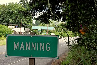
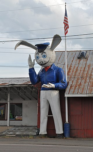
Manning is an unincorporated community in Washington County, Oregon, United States on the Sunset Highway. The Banks–Vernonia State Trail, a rail trail conversion, passes through Manning. The NorthWest POINT offers twice-daily roundtrip intercity bus service between Portland and Astoria with a flag stop in Manning.

<span class="mw-page-title-main">Chehalem Mountains</span> Mountain range named for a band of the Atfalati people

The Chehalem Mountains are a mountain range located in the Willamette Valley in the U.S. state of Oregon. Forming the southern boundary of the Tualatin Valley, the Chehalems are the highest mountains in the Willamette Valley. The range extends from the Willamette River east of Newberg northwest to the foothills of the Oregon Coast Range south of Forest Grove.

<i>Lake County Examiner</i>

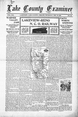
The Lake County Examiner is a weekly newspaper published in Lakeview, Oregon, United States. It was founded in 1880 by Stephen P. Moss and Charles A. Cogswell. Over the years, the paper has had a number of publishers. Today, the newspaper is owned by Adams Publishing Group. In addition to the weekly newspaper, the Examiner staff publishes a number of special editions each year along with a local real estate guide and a twice-weekly news flyer.

Copper is a former community in Jackson County, Oregon, United States. Copper was located about 1 mile (1.6 km) north of the Oregon–California border, near the mouth of Carberry Creek. Copper was named for the copper mining in the region, including at the Blue Ledge mine just over the state line in California. The town had a post office from 1924 until 1932. The elevation of Copper is 1,949 feet.

<span class="mw-page-title-main">Kelley Point Park</span> Public park in Portland, Oregon, U.S.

Kelley Point Park is a city park in north Portland in the U.S. state of Oregon. Bounded by the Columbia Slough on the south, the Willamette River on the west, and the Columbia River on the north, the park forms the tip of the peninsula at the confluence of the rivers. Marine Terminal 6 of the Port of Portland lies immediately east of the park along the Columbia, while Terminal 5 is along the Willamette slightly south of the Columbia Slough. The park is at 45.6498384°N 122.7637106°W and rises to an elevation of 39 feet (12 m) above sea level. Sauvie Island is west of the park across the Willamette River. Hayden Island is slightly upstream of the park on the Columbia River opposite Marine Terminal 6.

<span class="mw-page-title-main">Oregon Geographic Names Board</span>

The Oregon Geographic Names Board is responsible for recommending names for geographic features in the state of Oregon. The board submits its recommendations to the United States Board on Geographic Names for approval. In 1959, administrative responsibility for the board was transferred from the state government to the Oregon Historical Society.

<span class="mw-page-title-main">Charles S. Drew</span> American Union Army officer (1825–1886)

Charles Stewart Drew, also known as C.S. Drew, was a representative in the legislature of the Oregon Territory of the United States and quartermaster general of the territorial militia in the 1850s. During the American Civil War, he was a Union Army officer, serving in the 1st Oregon Cavalry regiment. He eventually reached the rank of lieutenant colonel. In 1864, he led an Army reconnaissance party into southeastern Oregon. The expedition, known as the Owyhee Reconnaissance, traveled through uncharted country from Fort Klamath to Fort Boise and back. Drew was the author of two historically important military reports; one documented Indian attacks on American settlers in the Oregon Territory and the other was his report of the Owyhee Reconnaissance.

<span class="mw-page-title-main">Catlow Valley</span>

The Catlow Valley is a basin in Harney County, Oregon, United States. It is a remote valley at the northwestern corner of North America's Basin and Range Province. The valley is named after a pioneer rancher, John Catlow. The area was used by Native Americans for thousands of years before European explorers arrived in the 19th century. Today, cattle ranching is the main commercial activity in the valley. The public land in the Catlow Valley is administered by the Bureau of Land Management. This public land offers a number of recreational opportunities including hiking, hunting, fishing, bird watching, and wildlife viewing.

<span class="mw-page-title-main">William H. Warner</span>

William Horace Warner was an officer in the United States Army's Corps of Topographical Engineers. In 1849, he led an Army survey party north from Sacramento through the uncharted country of northeastern California into south central Oregon. Warner was killed by Native Americans in northeastern California, just south of the Oregon border. In the mid-nineteenth century, two army outposts in southern Oregon were named after Warner. Today, the Warner Mountains, Warner Valley, and a number of other landmarks bear his name.

<span class="mw-page-title-main">Blitzen, Oregon</span> Unincorporated community in the state of Oregon, United States

Blitzen is a ghost town in the Catlow Valley of southern Harney County, Oregon.

<span class="mw-page-title-main">Swan Island (Oregon)</span> Island on the Willamette River in Portland, Oregon, U.S.

Swan Island is located on the Willamette River about 4.5 miles (7.2 km) downriver from downtown Portland, Oregon, United States. Although presently connected to the Willamette's east bank by land fill, it existed as a river island under natural conditions.

References

  1. McArthur & McArthur 2003, Introduction p. xi.
  2. McArthur & McArthur 2003, A B Crossing p. 1.
  3. McArthur & McArthur 2003, Zwagg Island p. 1070.
  4. "Book publishing". The Oregon Encyclopedia .
  5. McArthur, Lewis Ankeny (1974). Oregon Geographic Names: McArthur, Lewis Ankeny), 1883-1951 (Fourth ed.). ISBN   9780875950389 . Retrieved August 9, 2020.
  6. McArthur & McArthur 2003.
  7. McArthur & McArthur 2003, Preface p. viii.
  8. Perry, Douglas (September 7, 2018). "Lewis McArthur, who set state's geographic names standard, dies". The Oregonian. p. A14.
  9. Welch, Bob (June 22, 2008). "When studying Oregon names, McArthur reins [sic]". The Register-Guard . p. C17. Retrieved August 14, 2009.
  10. Welch, Bob (September 9, 2008). "Place name takes its place on the map". The Register-Guard. p. B13. Retrieved August 14, 2009.
  11. Richard, Terry (December 26, 2009). "Opie Dilldock Pass? Noti? What's in an Oregon name?". The Oregonian. Retrieved February 3, 2012.