
The Bitterroot River is a northward flowing 84-mile (135 km) river running through the Bitterroot Valley, from the confluence of its West and East forks near Conner in southern Ravalli County to its confluence with the Clark Fork River near Missoula in Missoula County, in western Montana. The Clark Fork River is tributary to the Columbia River and ultimately, the Pacific Ocean. The Bitterroot River is a Blue Ribbon trout fishery with a healthy population of native westslope cutthroat trout and bull trout. It is the third most fly fished river in Montana behind the Madison and Big Horn Rivers.

Lahontan cutthroat trout is the largest subspecies of cutthroat trout, and the state fish of Nevada. It is one of three subspecies of cutthroat trout that are listed as federally threatened.

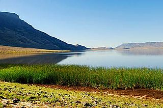
Fish Lake is a high alpine lake located in the Fishlake/ Southern Wasatch Plateau region of south-central Utah, United States. It lies within and is the namesake of the Fishlake National Forest.

The Metolius River is a tributary of the Deschutes River in Central Oregon, United States, near the city of Sisters. The river flows north from springs near Black Butte, then turns sharply east, descending through a series of gorges before ending in the western end of the lake. The unincorporated community of Camp Sherman lies astride the southern end of the river. The name of the river comes from the Warm Springs or Sahaptin word mitula, meaning white salmon and referring to a light colored Chinook salmon and not a whitefish.

Malheur National Wildlife Refuge is a National Wildlife Refuge located roughly 30 miles (48 km) south of the city of Burns in Oregon's Harney Basin. Administered by the United States Fish and Wildlife Service, the refuge area is roughly T-shaped with the southernmost base at Frenchglen, the northeast section at Malheur Lake and the northwest section at Harney Lake.

The California Department of Fish and Wildlife (CDFW), formerly known as the California Department of Fish and Game (CDFG), is a state agency under the California Natural Resources Agency. The Department of Fish and Wildlife manages and protects the state's wildlife, wildflowers, trees, mushrooms, algae (kelp) and native habitats (ecosystems). The department is responsible for regulatory enforcement and management of related recreational, commercial, scientific, and educational uses. The department also prevents illegal poaching.

The Crooked River is a tributary, 125 miles (201 km) long, of the Deschutes River in the U.S. state of Oregon. The river begins at the confluence of the South Fork Crooked River and Beaver Creek. Of the two tributaries, the South Fork Crooked River is the larger and is sometimes considered part of the Crooked River proper. A variant name of the South Fork Crooked River is simply "Crooked River". The Deschutes River flows north into the Columbia River.

Chandler State Wayside is a state park in south-central Oregon in the United States. It is named in honor of Solomon and Hattie Chandler, who donated the land for the park. The park covers 85 acres (34 ha) of pine forest along a creek. The park provides restrooms and other basic facilities to accommodate the traveling public. Chandler State Wayside is administered by the Oregon Parks and Recreation Department.

Diamond Lake is a natural body of water in the southern part of the U.S. state of Oregon. It lies near the junction of Oregon Route 138 and Oregon Route 230 in the Umpqua National Forest in Douglas County. It is located between Mount Bailey to the west and Mount Thielsen to the east; it is just north of Crater Lake National Park.

Leaburg is an unincorporated community in Lane County, Oregon, United States located on the McKenzie River and Oregon Route 126 east of Walterville and west of Vida.

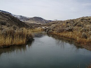
The Wood River is a short river in the southern region of the U.S. state of Oregon, and part of the Klamath Basin drainage. It flows 18 miles (29 km) through the Fremont-Winema National Forests, Bureau of Land Management land, and private property in southern Oregon. Its watershed consists of 220 square miles (570 km2) of conifer forest, rural pasture land, and marsh. The river provides habitat for many species of wildlife including an adfluvial (migratory) and resident populations of native Great Basin redband trout.
Hart Lake is a shallow lake in the Warner Valley of eastern Lake County, Oregon, United States. The lake covers 7,324 acres (29.64 km2) and has the most stable water level within the valley's Warner Lakes chain. The lake is named for the heart-shaped brand used by the pioneer Wilson and Alexander cattle ranch established near the lake. Much of the land around Hart Lake is administered by the Bureau of Land Management (BLM) and the United States Fish and Wildlife Service (FWS). The lake and the surrounding wetlands support a wide variety of birds and other wildlife. Recreational opportunities on and near Hart Lake include hunting, fishing, bird watching, and boating.
The Ana River is a short spring-fed river in south-central Oregon. It is on the northwestern edge of the Great Basin drainage. It flows 7 miles (11 km) from springs at the foot of Winter Ridge through high desert, range, and wetlands before emptying into Summer Lake. For most of its course, the Ana River flows through the Summer Lake Wildlife Area, which is maintained by the Oregon Department of Fish and Wildlife. The river provides habitat for many mammal and bird species, as well as several fish species, including the rare Summer Lake Tui chub. The largest hybrid striped bass ever caught in Oregon was taken from Ana Reservoir in 2009.

The Summer Lake Wildlife Area is a 29.6-square-mile (77 km2) wildlife refuge located on the northwestern edge of the Great Basin drainage in south-central Oregon. It is administered by the Oregon Department of Fish and Wildlife. The refuge is an important stop for waterfowl traveling along the Pacific Flyway during their spring and fall migrations. The Summer Lake Wildlife Area also provides habitat for shorebirds and other bird species as well as wide variety of mammals and several fish species. The Ana River supplies the water for the refuge wetlands.
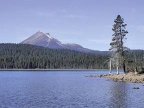
Lake of the Woods is a natural lake near the crest of the Cascade Range in the Fremont–Winema National Forest in southern Oregon in the United States. The lake covers 1,146 acres (4.64 km2). It was named by Oliver C. Applegate in 1870. Today, the Oregon Department of Fish and Wildlife manages the lake's fishery. The small unincorporated community of Lake of the Woods is located on the east shore of the lake. Lake of the Woods is one of southern Oregon's most popular outdoor recreation sites.

Salt Creek is a tributary, 30 miles (48 km) long, of the Middle Fork Willamette River in Lane County in the U.S. state of Oregon. It is named for salt springs along its banks that are used as licks by deer. The stream originates as an outflow of Lower Betty Lake in the forested Cascade Range just southeast of Waldo Lake. From its source, Salt Creek flows generally south, through Gold Lake, to Route 58, which it then follows mainly northwest for about 26 miles (42 km) to its mouth at the Middle Fork Willamette River just below Hills Creek Dam. At Salt Creek Falls—roughly 4 miles (6.4 km) west of Willamette Pass and a little more than 22 miles (35 km) upstream from the mouth—the stream plunges 286 feet (87 m), discharging an average of 50,000 U.S. gallons (190,000 L) of water per minute, or 111 cubic feet per second (3.1 m3/s). Below the falls, the creek enters a narrow canyon shaped by glaciation and basalt lava flows from higher in the Cascades. McCredie Hot Springs, at the former community of McCredie Springs, are natural hot springs along the lower half of Salt Creek beside Route 58.

The North Fork Alsea River is a 16-mile (26 km) tributary of the Alsea River in the U.S. state of Oregon. It begins at Klickitat Lake, fed by Klickitat and Lake creeks in the Central Oregon Coast Range, and flows generally south to near Alsea, where it joins the South Fork Alsea River to form the main stem. For most of its course, the North Fork winds through the Siuslaw National Forest in Lincoln County and then Benton County. It passes under Oregon Route 34 northeast of Alsea.

Crump Lake is a shallow lake in the Warner Valley of eastern Lake County, Oregon, United States. The lake covers 7,680 acres (31.1 km2). It is the largest of the Warner Lakes system. The lake is named for pioneer rancher Thomas Crump. Crump Lake is owned by the Oregon Department of State Lands. Much of the land around the lake is administered by the Bureau of Land Management and the United States Fish and Wildlife Service. The lake and the surrounding wetlands support a wide variety of birds and other wildlife. Recreational opportunities on or near Crump Lake include fishing, bird watching, and camping.
Pine Hollow Reservoir is an impoundment of water from Threemile and Pine Hollow creeks on the east flank of the Cascade Range in Wasco County, Oregon, United States. The reservoir, created in the 1960s to provide water for irrigation, lies on private land about 12 miles (19 km) west-northwest of Maupin near the boundary of the Mount Hood National Forest. Public access and fishing are permitted along most of the 3.2-mile (5.1 km) shoreline of the reservoir.
Cooper Lake is an alpine freshwater lake located on the southern stretch of the Alpine Lakes Wilderness in Kittitas County, Washington. Because of its proximity to Cle Elum Lake and Kachess Lake, Cooper Lake is a popular area for hiking, camping and fishing. Cooper Lake, where two-pole fishing is permitted, is stocked annually with Kokanee salmon and several species of trout fish. Cooper Lake is the starting point for trails that lead to other Alpine lakes in the vicinity, including the Pete Lake and Spectacle Lake at the base of Chikamin Peak.


