Heppner, Oregon

Last updated

Heppner, Oregon
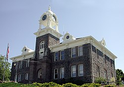
Museum Building (Morrow County, Oregon scenic images) (morD0092).jpg
The Agricultural Collection Building of the Morrow County Museum in Heppner
Heppner Oregon City Seal.png
Nickname: 
Gateway to the Blues
Morrow County Oregon Incorporated and Unincorporated areas Heppner Highlighted.svg
Location in Oregon
Coordinates: 45°21′17″N119°33′21″W / 45.35472°N 119.55583°W / 45.35472; -119.55583
CountryUnited States
State Oregon
County Morrow
Incorporated 1887
Government
   Mayor Corey Sweeney [1]
Area
[2]
  Total1.24 sq mi (3.20 km2)
  Land1.23 sq mi (3.19 km2)
  Water0.01 sq mi (0.02 km2)
Elevation
[3]
2,011 ft (613 m)
Population
 (2020) [4]
  Total1,187
  Density965.04/sq mi (372.65/km2)
Time zone UTC−8 (Pacific)
  Summer (DST) UTC−7 (Pacific)
ZIP code
97836
Area code(s) 458 and 541
FIPS code 41-33550 [5]
GNIS feature ID2410745 [3]
Website www.cityofheppner.com

Heppner is a city in, and the county seat of, Morrow County, Oregon, United States. As of 2010, the population was 1,291. [6] Heppner is part of the Pendleton-Hermiston Micropolitan Area. Heppner is named after Henry Heppner, a prominent Jewish-American businessman.

Contents

History

Native American settlement

Native Americans lived and traveled along the land between the Columbia Gorge and the Blue Mountains for more than 10,000 years prior to European-American settlement. Ancient petroglyphs have been found approximately 45 miles (72 km.) north of Heppner in Irrigon and Boardman. [7] In 1855, the U.S. Government and the predominant tribes in the region—the Cayuse, Umatilla, and Walla Walla—signed a treaty whereby the tribes gave up, or ceded, to the United States more than 6.4 million acres in what is now northeastern Oregon and southeastern Washington. [8]

European-American settlement

Prior to Heppner's founding in 1872, European-American ranchers used the area as sheep and cattle range as early as 1858. Records suggest these early cattlemen found abundant rye grass along creek bottoms. [9]

Heppner was originally called Standsbury Flats for George W. Standsbury, one of the first European-American settlers in the area. [10] [11] [12] In 1872, Colonel (Col.) Jackson Lee Morrow, a merchant, entered into a partnership with Henry Heppner, a prominent Jewish businessman, [13] and they built a store on the crossing of the present May and Main streets. [12] [9] [10] Soon thereafter, a mail and stagecoach line began operations between Pendleton and The Dalles and passed through Heppner. [14]

Col. Jackson Lee Morrow was later elected to the Oregon legislative assembly and was instrumental in helping to carve out a new county for Heppner from neighboring Umatilla County and a portion of Wasco County. [15] The assembly named the new county in Morrow's honor. [14]

Heppner was designated the temporary county seat at the time the county was created and narrowly defeated nearby Lexington in an election held in 1886 to determine the permanent county seat. [10] [16] Heppner was incorporated in the following year on February 9, 1887. [17] [12]

In 1888, the Oregon Railroad and Navigation Company completed a railroad spur from the Columbia River up the Willow Creek drainage to Heppner. [14]

The Historic Morrow County Courthouse was built in 1902-03 and is one of the oldest continuously used courthouses in Oregon. [18] In 1985, the courthouse was listed on the National Register of Historic Places. [19]

Historic Morrow County Courthouse HeppnerMorrowcourthouse.jpg
Historic Morrow County Courthouse

Flood of June 1903

Heppner was almost destroyed by a flash flood on Sunday, June 14, 1903. [20] The flood was precipitated by a sudden cloudburst and accompanying hail that caused a debris dam collapse and flash flooding, notably on Willow Creek. [20] A wall of water and debris swept down the creeks and canyons and through the city. It has been estimated that 238 people (a quarter of the city's population) drowned, making it the deadliest natural disaster in Oregon's history. [20] Property damage was reported at nearly $1 million. The nearby cities of Ione and Lexington also sustained significant damage. [20] In 1983, the Willow Creek Dam at the outskirts of the city was finished. [20]

Willow Creek Lake and Dam USACE Willow Creek Dam Oregon.jpg
Willow Creek Lake and Dam

Post-flood recovery

The railroad and a growing network of roads had by the early decades of the 20th century made Heppner a trade center and distribution point for regional farm products including wheat, alfalfa, sheep, cattle, horses, and hogs. Despite the flood and two fires in 1918 that destroyed City Hall, the Palace Hotel, the library, many businesses, and more than 30 homes, the community rebuilt. One of its creations, the Heppner Hotel, opened in 1920 and, housing a variety of businesses over the years, it served as a community gathering place through 1972, when its last restaurant closed. [14]

Old Heppner Hotel Heppner Hotel - Heppner Oregon.jpg
Old Heppner Hotel

Later history

In 1940, a major sawmill was built in the town by the Heppner Lumber Company, helping drive the area's economy. [21] The mill was destroyed by fire in 1949, but was rebuilt and sold to Kinzua Lumber Company, which ultimately relocated its headquarters to Heppner. [21] In 1999, the mill closed, [22] dealing a significant blow to Heppner's economy [21] and resulting in the loss of nearly 200 jobs. [23]

Demographics

Historical population
CensusPop.Note
1880 318
1890 675112.3%
1900 1,14669.8%
1910 880−23.2%
1920 1,32450.5%
1930 1,190−10.1%
1940 1,140−4.2%
1950 1,64844.6%
1960 1,6610.8%
1970 1,429−14.0%
1980 1,4984.8%
1990 1,412−5.7%
2000 1,395−1.2%
2010 1,291−7.5%
2020 1,187−8.1%
source: [5] [24] [4]

Census estimates

As of July 1, 2016, the annual estimate of the resident population of Heppner was 1,297. [25]

2010 Census

As of the census of 2010, there were 1,291 people, 559 households, and 370 families residing in the city. The population density was 1,049.6 inhabitants per square mile (405.3/km2). There were 647 housing units at an average density of 526.0 per square mile (203.1/km2). The racial makeup of the city was 92.5% White, 0.2% African American, 1.2% Native American, 0.3% Asian, 2.6% from other races, and 3.3% from two or more races. Hispanic or Latino of any race were 3.7% of the population. [5]

There were 559 households, of which 26.1% had children under the age of 18 living with them, 53.3% were married couples living together, 8.2% had a female householder with no husband present, 4.7% had a male householder with no wife present, and 33.8% were non-families. 29.3% of all households were made up of individuals, and 14.5% had someone living alone who was 65 years of age or older. The average household size was 2.30 and the average family size was 2.78. [5]

The median age in the city was 45.9 years. 22.5% of residents were under the age of 18; 6.5% were between the ages of 18 and 24; 19.6% were from 25 to 44; 29.8% were from 45 to 64; and 21.5% were 65 years of age or older. The gender makeup of the city was 50.6% male and 49.4% female. [5]

2000 Census

As of the census of 2000, there were 1,395 people, 583 households, and 398 families residing in the city. The population density was 1,138.5 inhabitants per square mile (439.6/km2). There were 660 housing units at an average density of 538.7 per square mile (208.0/km2). The racial makeup of the city was 96.70% White, 1.00% Native American, 0.43% Asian, 1.51% from other races, and 0.36% from two or more races. Hispanic or Latino of any race were 1.58% of the population. [5]

There were 583 households, out of which 28.8% had children under the age of 18 living with them, 56.6% were married couples living together, 7.5% had a female householder with no husband present, and 31.7% were non-families. 28.1% of all households were made up of individuals, and 14.8% had someone living alone who was 65 years of age or older. The average household size was 2.36 and the average family size was 2.88. [5]

In the city, the population was spread out, with 24.5% under the age of 18, 5.9% from 18 to 24, 24.3% from 25 to 44, 24.9% from 45 to 64, and 20.3% who were 65 years of age or older. The median age was 42 years. For every 100 females, there were 100.7 males. For every 100 females age 18 and over, there were 92.9 males. [5]

The median income for a household in the city was $33,421, and the median income for a family was $42,500. Males had a median income of $37,381 versus $20,714 for females. The per capita income for the city was $16,729. About 11.1% of families and 13.9% of the population were below the poverty line, including 18.9% of those under age 18 and 7.0% of those age 65 or over. [5]

Geography

Heppner is located between the Columbia River to the north and the Blue Mountains to the southeast. [26] The city is along Oregon Route 74, about 60 miles (97 km) southwest of Pendleton and 185 miles (298 km) east of Portland. [26] [27]

Route 74 forms part of the Blue Mountain Scenic Byway, a 130-mile (210 km) set of roads connecting Interstate 84 (I-84) along the Columbia River with the North Fork John Day River in the Blue Mountains. Part of the route follows the Willow Creek drainage through Heppner. [28]

Heppner is upstream of Lexington, Ione, and Arlington. [26] According to the United States Census Bureau, the city has a total area of 1.24 square miles (3.21 km2), of which, 1.23 square miles (3.19 km2) is land and 0.01 square miles (0.03 km2) is water. [29]

Climate

According to the Köppen Climate Classification system, Heppner has a warm-summer mediterranean climate, abbreviated "Csb" on climate maps. The hottest temperature recorded in Heppner was 110 °F (43.3 °C) on August 10, 1898, while the coldest temperature recorded was −19 °F (−28.3 °C) on January 10, 1909 and January 12, 1909. [30]

Climate data for Heppner, Oregon, 1991–2020 normals, extremes 1893–present
MonthJanFebMarAprMayJunJulAugSepOctNovDecYear
Record high °F (°C)70
(21)
75
(24)
80
(27)
92
(33)
100
(38)
109
(43)
108
(42)
110
(43)
99
(37)
92
(33)
80
(27)
75
(24)
110
(43)
Mean maximum °F (°C)61.9
(16.6)
62.4
(16.9)
68.8
(20.4)
76.6
(24.8)
87.1
(30.6)
93.2
(34.0)
99.1
(37.3)
98.7
(37.1)
90.9
(32.7)
80.0
(26.7)
68.2
(20.1)
59.8
(15.4)
100.8
(38.2)
Mean daily maximum °F (°C)43.6
(6.4)
47.4
(8.6)
54.7
(12.6)
60.8
(16.0)
69.4
(20.8)
76.6
(24.8)
86.8
(30.4)
86.1
(30.1)
77.3
(25.2)
63.8
(17.7)
51.0
(10.6)
42.5
(5.8)
63.3
(17.4)
Daily mean °F (°C)35.6
(2.0)
38.3
(3.5)
44.2
(6.8)
49.3
(9.6)
56.9
(13.8)
63.1
(17.3)
71.0
(21.7)
70.4
(21.3)
62.8
(17.1)
51.7
(10.9)
41.6
(5.3)
34.9
(1.6)
51.7
(10.9)
Mean daily minimum °F (°C)27.6
(−2.4)
29.2
(−1.6)
33.6
(0.9)
37.8
(3.2)
44.5
(6.9)
49.5
(9.7)
55.1
(12.8)
54.7
(12.6)
48.3
(9.1)
39.5
(4.2)
32.2
(0.1)
27.2
(−2.7)
39.9
(4.4)
Mean minimum °F (°C)11.9
(−11.2)
14.2
(−9.9)
22.9
(−5.1)
27.4
(−2.6)
33.0
(0.6)
39.1
(3.9)
44.5
(6.9)
44.7
(7.1)
37.1
(2.8)
25.9
(−3.4)
17.7
(−7.9)
11.4
(−11.4)
4.3
(−15.4)
Record low °F (°C)−19
(−28)
−18
(−28)
3
(−16)
15
(−9)
25
(−4)
31
(−1)
32
(0)
35
(2)
19
(−7)
10
(−12)
−9
(−23)
−18
(−28)
−19
(−28)
Average precipitation inches (mm)1.32
(34)
1.07
(27)
1.36
(35)
1.46
(37)
1.71
(43)
1.35
(34)
0.31
(7.9)
0.28
(7.1)
0.43
(11)
1.17
(30)
1.37
(35)
1.26
(32)
13.09
(333)
Average snowfall inches (cm)3.0
(7.6)
3.4
(8.6)
0.9
(2.3)
0.1
(0.25)
0.0
(0.0)
0.0
(0.0)
0.0
(0.0)
0.0
(0.0)
0.0
(0.0)
0.2
(0.51)
0.9
(2.3)
4.3
(11)
12.8
(32.56)
Average precipitation days (≥ 0.01 in)11.010.111.811.010.27.22.72.33.78.611.712.1102.4
Average snowy days (≥ 0.1 in)2.52.00.60.10.00.00.00.00.00.10.72.48.4
Source 1: NOAA [31]
Source 2: National Weather Service [30]

Annual cultural events

Heppner hosts an annual "A Wee Bit O'Ireland" celebration around Saint Patrick's Day. [32] [33] The city also hosts the annual Blue Mountain Century Bikeway, a scenic bicycle ride loop of approximately 108 miles starting and ending in Heppner. [34] [35]

Economy and education

As of 2002, the five largest employers in Heppner were Morrow County, the Morrow County Health District, the Morrow County School District, the Heppner Ranger District, and the Bank of Eastern Oregon. [27]

Heppner is served by the Morrow School District, which includes Heppner Junior/Senior High School and Heppner Elementary. [36] Heppner is also served by the Heppner Branch of the Oregon Trail Library District, part of Oregon's Sage Library System.

Government

Local

Heppner is a municipal corporation with the official name City of Heppner per the 1996 Heppner Charter. The powers of the city are vested in the city council which consists of a mayor and six council members each nominated and elected from the city at large or, in case of one or more vacancies in the council, the council members whose offices are not vacant. The mayor serves two-year terms and the council members serve four-year terms. Heppner also maintains a city manager who is appointed by, and may be removed by, a majority of the entire city council. The appointment of city manager is made without regard to political considerations and solely on the basis of administrative qualifications. The mayor votes as a council member with no appointive powers. [37]

As of 2023, Corey Sweeney serves as mayor. Council members include Ralph Klock, Ian Murray, Cody High, Dale Bates, Sharon Inskeep, and Adam Doherty. John Doherty serves as the City Manager. [1]

State

Heppner is part of Oregon State House District 57 which includes Gilliam, Morrow, Sherman, Umatilla, and Wasco counties and of Oregon State Senate District 29 which includes Gilliam, Morrow Sherman, Umatilla, Union, Wallowa, and parts of Wasco counties. As of September 2017, Representative Greg Smith (R) serves Heppner in the Oregon State House and Senator Bill Hansell (R) serves Heppner in the Oregon State Senate. [38] [39]

Federal

Heppner is part of Oregon's Second Congressional District. As of January 2023, Heppner is represented by U.S. Rep. Cliff Bentz (R). Separately, congressional senators for Oregon include Jeff Merkley (D) and Ron Wyden (D).

Notable people

Related Research Articles

<span class="mw-page-title-main">Walla Walla County, Washington</span> County in Washington, United States

Walla Walla County is a county located in the southeast of the U.S. state of Washington. As of the 2020 census, its population was 62,584. The county seat and largest city is Walla Walla. The county was formed on April 25, 1854 and is named after the Walla Walla tribe of Native Americans.

<span class="mw-page-title-main">Columbia County, Washington</span> County in Washington, United States

Columbia County is a county located in the U.S. state of Washington. As of the 2020 census, the population was 3,952, making it the second-least populous county in Washington. The county seat and largest city is Dayton. The county was created out of Walla Walla County on November 11, 1875, and is named after the Columbia River. Columbia County is included in the Walla Walla, WA Metropolitan Statistical Area.

<span class="mw-page-title-main">Union County, Oregon</span> County in Oregon, United States

Union County is one of the 36 counties in the U.S. state of Oregon, and one of the 8 counties of eastern Oregon. As of the 2020 census, the population was 26,196. The county comprises the La Grande micropolitan statistical area and the county seat is La Grande.

<span class="mw-page-title-main">Umatilla County, Oregon</span> County in Oregon, United States

Umatilla County is one of the 36 counties in the U.S. state of Oregon. The population of 81,826 ranks it as the 14th largest in Oregon, and largest in Eastern Oregon. Hermiston is the largest city in Umatilla County, but Pendleton remains the county seat. Umatilla County is part of the Hermiston-Pendleton, OR Micropolitan Statistical Area, which has a combined population of 94,833. It is included in the eight-county definition of Eastern Oregon.

<span class="mw-page-title-main">Morrow County, Oregon</span> County in Oregon, United States

Morrow County is one of the 36 counties in the U.S. state of Oregon. As of the 2020 census, the population was 12,186. The county seat is Heppner. The county is named for one of its first settlers, Jackson L. Morrow, who was a member of the state legislature when the county was created. Half of the Umatilla Chemical Depot, which includes the Umatilla Chemical Agent Disposal Facility, and the Naval Weapons Systems Training Facility Boardman are located within the county. Morrow County is part of the Pendleton-Hermiston, OR, Micropolitan Statistical Area. It is located on the south side of the Columbia River and is included in the eight-county definition of Eastern Oregon.

<span class="mw-page-title-main">Grant County, Oregon</span> County in Oregon, United States

Grant County is one of the 36 counties in the U.S. state of Oregon. As of the 2020 census, the population was 7,233, making it Oregon's fourth-least populous county. The county seat is Canyon City. It is named for President Ulysses S. Grant, who served as an army officer in the Oregon Territory, and at the time of the county's creation was a Union general in the American Civil War.

<span class="mw-page-title-main">Boardman, Oregon</span> City in Oregon, United States

Boardman is a city in Morrow County, Oregon, United States on the Columbia River and Interstate 84. As of the 2020 census the population was 3,828. It is currently the largest town in Morrow County, Oregon.

<span class="mw-page-title-main">Ione, Oregon</span> City in Oregon, United States

Ione is a city in Morrow County, Oregon, United States. The population was 329 at the 2010 census. It is part of the Pendleton–Hermiston Micropolitan Statistical Area.

<span class="mw-page-title-main">Irrigon, Oregon</span> City in Morrow County, Oregon, United States

Irrigon is a city in Morrow County, Oregon, United States, on the Columbia River and U.S. Route 730. The city is part of the Pendleton–Hermiston Micropolitan Statistical Area. The population was 1,826 at the 2010 census.

<span class="mw-page-title-main">Lexington, Oregon</span> City in Oregon, United States

Lexington is a city in Morrow County, Oregon, United States. The population was 238 at the 2010 census. It is part of the Pendleton–Hermiston Micropolitan Statistical Area.

<span class="mw-page-title-main">Athena, Oregon</span> City in Oregon, United States

Athena is a city in Umatilla County, Oregon, United States. The population was 1,126 at the 2010 census. It is part of the Hermiston-Pendleton Micropolitan Statistical Area.

<span class="mw-page-title-main">Hermiston, Oregon</span> City in Oregon, United States

Hermiston is a city in Umatilla County, Oregon, United States. Its population of 20,322 makes it the largest city in Eastern Oregon. Hermiston is the largest and fastest-growing city in the Hermiston-Pendleton Micropolitan Statistical Area, the eighth largest Core Based Statistical Area in Oregon with a combined population of 92,261 at the 2020 census. Hermiston sits near the junction of I-82 and I-84, and is 7 miles south of the Columbia River, Lake Wallula, and the McNary Dam. The Hermiston area has become a hub for logistics and data center activity due to the proximity of the I-82 and I-84 interchange, Pacific Northwest fiber optic backbone, and low power costs.

<span class="mw-page-title-main">Milton-Freewater, Oregon</span> City in Oregon, United States

Milton-Freewater is a city in Umatilla County, Oregon, United States. The city received its current name in 1951 when neighboring rival cities of Milton and Freewater voted to merge. The population was 7,151 at the 2020 census. It is part of the Pendleton–Hermiston Micropolitan Statistical Area. Milton-Freewater is home to a growing wine industry.

<span class="mw-page-title-main">Pendleton, Oregon</span> City in Oregon, United States

Pendleton is a city in and the county seat of Umatilla County, Oregon, United States. The population was 17,107 at the time of the 2020 census, which includes approximately 1,600 people who are incarcerated at Eastern Oregon Correctional Institution.

<span class="mw-page-title-main">Ukiah, Oregon</span> City in Oregon, United States

Ukiah (/juːkaɪʌ/) is a city in Umatilla County, Oregon, United States. The population was 186 at the 2010 census. It is part of the Hermiston-Pendleton Micropolitan Statistical Area. It was named by an early settler after the town of Ukiah, California.

<span class="mw-page-title-main">Umatilla, Oregon</span> City in Oregon, United States

Umatilla is a city in Umatilla County, Oregon, United States. The population in 2010 was 6,906, but the city's population includes approximately 2,000 inmates incarcerated at Two Rivers Correctional Institution.

<span class="mw-page-title-main">La Grande, Oregon</span> City in Oregon, United States

La Grande is a city in Union County, Oregon, United States. La Grande is Union County's largest city, with a population of 13,082 at the time of the 2010 U.S. Census. The La Grande metro population is 25,076. It is the 16th largest metropolitan area in Oregon.

<span class="mw-page-title-main">Umatilla National Forest</span> National forest in the U.S. states of Oregon and Washington

The Umatilla National Forest, in the Blue Mountains of northeast Oregon and southeast Washington, covers an area of 1.4 million acres (5,700 km2). In descending order of land area the forest is located in parts of Umatilla, Grant, Columbia, Morrow, Wallowa, Union, Garfield, Asotin, Wheeler, and Walla Walla counties. More than three-quarters of the forest lies in the state of Oregon. Forest headquarters are located in Pendleton, Oregon. There are local ranger district offices in Heppner and Ukiah in Oregon, and in Pomeroy and Walla Walla in Washington.

<span class="mw-page-title-main">Oregon Route 207</span> Highway in Oregon

Oregon Route 207 is an Oregon state highway running from U.S. Route 26 in Mitchell to U.S. Route 730 near Cold Springs Junction. OR 207 is 152.30 miles (245.10 km) long and runs north–south.

<span class="mw-page-title-main">Hermiston-Pendleton Micropolitan Statistical Area</span> United States census area

The Hermiston-Pendleton Micropolitan Statistical Area, as defined by the United States Census Bureau, is an area consisting of two counties in Oregon anchored by the cities of Hermiston and Pendleton. Although the two communities are generally linked, the Hermiston area has been growing much faster, and is now nearly double the size of the Pendleton area. Portland State University projects that 80% of all growth in the MSA will occur in the immediate Hermiston vicinity between 2016 and 2035.

References

  1. 1 2 "City Council". cityofheppner.org. Retrieved December 28, 2023.
  2. "ArcGIS REST Services Directory". United States Census Bureau. Retrieved October 12, 2022.
  3. 1 2 U.S. Geological Survey Geographic Names Information System: Heppner, Oregon
  4. 1 2 "Census Population API". United States Census Bureau. Retrieved October 12, 2022.
  5. 1 2 3 4 5 6 7 8 9 "U.S. Census website". U.S. Census Bureau. Retrieved June 20, 2013.
  6. "2010 Census Profiles - Oregon Cities Alphabetically H‐L" (PDF). Population Research Center. Portland State University (PDX) - College of Urban and Public Affairs. August 2011. Archived from the original (PDF) on June 18, 2015. Retrieved August 29, 2017.
  7. "Columbia River Heritage Trail". Morrow County Oregon.
  8. "Treaty of 1855". Confederated Tribes of the Umatilla Indian Reservation. Cayuse, Umatilla, and Walla Walla people.
  9. 1 2 Capace, Nancy (1999). Encyclopedia of Oregon. Somerset Publishers. ISBN   0403098408.
  10. 1 2 3 "Morrow County History". Oregon Secretary of State - State Archives.
  11. McArthur, Lewis A.; Lewis L. McArthur (2003) [1928]. Oregon Geographic Names (7th ed.). Portland, Oregon: Oregon Historical Society Press. pp. 463–64. ISBN   0-87595-277-1.
  12. 1 2 3 "History of Heppner". Heppner Chamber of Commerce. Heppner Chamber of Commerce. Archived from the original on February 6, 2018.
  13. "Henry Heppner, Early Pioneer Jewish Businessman of Heppner, Oregon". Jewish Museum of the American West. The Western States Jewish History Association. October 7, 2015.
  14. 1 2 3 4 Hedman, Arnie; Belsma, Ronnie; Lynch, James (April 23, 1982). "National Register of Historic Places Registration Form: Heppner Hotel" (PDF). National Park Service. Retrieved July 20, 2013.
  15. "Extension in Northeastern Oregon". Oregon State University Libraries - Special Collections & Archives Research Center. July 6, 2011.
  16. Lynch, James E.; Derickson, Patrick M. (August 17, 1984). "National Register of Historic Places Registration Form: Morrow County Courthouse" (PDF). National Park Service. Retrieved July 18, 2013.
  17. "Heppner Community Profile". Infrastructure Finance Authority. 2009. Archived from the original on August 13, 2014. Retrieved July 18, 2013.
  18. "Historic Morrow County Courthouse". Heppner Chamber. Heppner Chamber of Commerce. Archived from the original on August 30, 2017.
  19. "Morrow County Courthouse". National Register of Historic Places Digital Archive. National Park Service. February 28, 1985.
  20. 1 2 3 4 5 Baker, Jeff (September 2, 2009). "'Calamity' : Discovering Oregon's Deadliest Natural Disaster". The Oregonian. Retrieved September 3, 2009.
  21. 1 2 3 Lent, Steve (June 3, 2023). "CENTRAL OREGON HISTORY: Heppner emerges as the gateway to the Blue Mountains". Madras Pioneer . Retrieved October 24, 2023.
  22. Plaven, George (November 2, 2016). "HEPPNER Wood-fueled power plant could see new life". East Oregonian. Retrieved October 24, 2023.
  23. Castillo, Elizabeth (May 3, 2023). "Morrow County OKs $1 billion deal in tax breaks with Amazon". Oregon Public Broadcasting . Retrieved October 24, 2023.
  24. Moffatt, Riley Moore (1996). Population History of Western U.S. Cities and Towns, 1850–1990. Lanham, Maryland: Scarecrow Press. p. 210. ISBN   978-0-8108-3033-2.
  25. U.S. Census Bureau. "Oregon - Annual Estimates of the Resident Population: April 1, 2010 to July 1, 2016". City and Town Population Totals Tables: 2010-2016. Archived from the original on June 2, 2017.
  26. 1 2 3 The 2013 Road Atlas. Chicago, Illinois: Rand McNally. 2013. pp. 84, 85. ISBN   978-052-80062-2-7.
  27. 1 2 "Heppner Community Profile". Oregon Infrastructure Finance Authority. 2009. Archived from the original on August 13, 2014. Retrieved July 19, 2013.
  28. Ostertag, Rhonda (2004). Backroads of Oregon: Your Guide to Oregon's Most Scenic Backroad Adventures. Stillwater, Minnesota: Voyageur Press. pp. 105–06. ISBN   0-89658-081-4.
  29. "2010 Census Gazetteer Files". United States Census Bureau . Retrieved June 20, 2013.
  30. 1 2 "NOAA Online Weather Data – NWS Pendleton". National Weather Service. Retrieved April 16, 2023.
  31. "U.S. Climate Normals Quick Access – Station: Heppner, OR". National Oceanic and Atmospheric Administration. Retrieved April 16, 2023.
  32. Malgesini, Tammy (March 10, 2011). "Leprechauns Plan Wee Bit o' Fun". East Oregonian. Pendleton, Oregon. Retrieved June 20, 2013.
  33. "31st Annual "A Wee Bit O'Ireland"". Heppner Chamber of Commerce. Archived from the original on March 3, 2018. Retrieved July 19, 2013.
  34. "Blue Mountain Century Bikeway | Heppner Chamber of Commerce". www.heppnerchamber.com. Archived from the original on September 18, 2017. Retrieved September 18, 2017.
  35. "Oregon Parks and Recreation Department: Scenic Bikeways Blue Mountain Century Scenic Bikeway". www.oregon.gov. Archived from the original on September 18, 2017. Retrieved September 18, 2017.
  36. "Our Schools". Morrow County School District. 2012. Retrieved June 28, 2012.
  37. "Sterling Codifiers, Inc". www.sterlingcodifiers.com. Retrieved September 18, 2017.
  38. 1 2 "Representative Greg Smith". GOP - District 57 (Umatilla, Morrow, Gilliam, Sherman & Wasco Counties).
  39. "Senator Bill Hansell". Official Oregon Legislature Website.

Further reading

Commons-logo.svg Media related to Heppner, Oregon at Wikimedia Commons