North Fork John Day River

Last updated
North Fork John Day River
North Fork of the John Day River (Umatilla County, Oregon scenic images) (umaDA0157).jpg
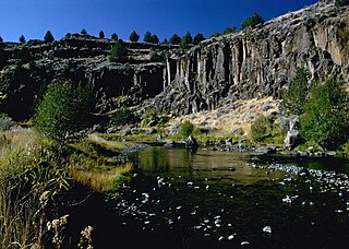
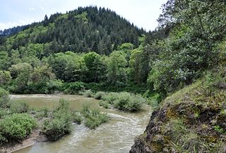
The river flowing beside Highway 395 in Umatilla County
USA Oregon location map.svg
Red pog.svg
Location of the mouth of the North Fork John Day River in Oregon
EtymologyJohn Day, fur trapper
Location
Country United States
State Oregon
County Grant County, Umatilla County
Physical characteristics
Source 
 - location Blue Mountains near Mount Ireland, Grant County, Oregon
 - coordinates 44°51′48″N118°14′13″W / 44.86333°N 118.23694°W / 44.86333; -118.23694 [1]
 - elevation7,466 ft (2,276 m) [2]
Mouth John Day River
 - location Kimberly, Grant County, Oregon
 - coordinates 44°45′22″N119°38′19″W / 44.75611°N 119.63861°W / 44.75611; -119.63861 Coordinates: 44°45′22″N119°38′19″W / 44.75611°N 119.63861°W / 44.75611; -119.63861 [1]
 - elevation1,834 ft (559 m) [1]
Length107 mi (172 km) [3] [4]
Discharge 
 - location Monument, Oregon, 15.3 miles (24.6 km) from mouth [5]
 - minimum6 cu ft/s (0.17 m3/s)
 - average1,297 cu ft/s (36.7 m3/s) [5]
 - maximum33,400 cu ft/s (950 m3/s)
Basin features
Basin size1,800 sq mi (4,700 km2) [6]
TypeWild, Scenic, Recreational
DesignatedOctober 28, 1988

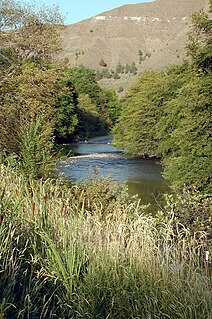
The North Fork John Day River is a 107-mile (172 km) tributary of the John Day River in the U.S. state of Oregon. It begins in Grant County about 20 miles (32 km) northwest of Baker City near the crest of the Blue Mountains. It flows generally west to the community of Dale on U.S. Route 395, then southwest through the city of Monument to the unincorporated community of Kimberly, where it meets the main stem of the John Day River.

John Day River Ttributary of the Columbia River in Oregon, USA

The John Day River is a tributary of the Columbia River, approximately 284 miles (457 km) long, in northeastern Oregon in the United States. Undammed along its entire length, the river is the third longest free-flowing river in the contiguous United States. There is extensive use of its waters for irrigation. Its course furnishes habitat for diverse species, including wild steelhead and Chinook salmon runs. However, the steelhead populations are under federal Endangered Species Act (ESA) protections, and the Chinook salmon have been proposed for such protection.

Oregon State of the United States of America

Oregon is a state in the Pacific Northwest region on the West Coast of the United States. The Columbia River delineates much of Oregon's northern boundary with Washington, while the Snake River delineates much of its eastern boundary with Idaho. The parallel 42° north delineates the southern boundary with California and Nevada. Oregon is one of only three states of the contiguous United States to have a coastline on the Pacific Ocean.

Grant County, Oregon County in the United States

Grant County is a county located in the U.S. state of Oregon. As of the 2010 census, the population was 7,445. The county seat is Canyon City. It is named for President Ulysses S. Grant, who served as an army officer in the Oregon Territory, and at the time of the county's creation was a Union general in the American Civil War.

Contents

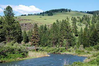
The upper reaches of the river flow through the North Fork John Day Wilderness in the Wallowa–Whitman National Forest and the Umatilla National Forest. From its headwaters to its confluence with Camas Creek, the river is part of the National Wild and Scenic River system. The upper 27.8 miles (44.7 km) is classified wild, the next 10.5 miles (16.9 km) scenic, and the next 15.8 miles (25.4 km) recreational, for a total of 54.1 miles (87.1 km). [7]

North Fork John Day Wilderness

The North Fork John Day Wilderness is a wilderness area within the Umatilla and Wallowa–Whitman National Forests in the Blue Mountains of northeastern Oregon.

Wallowa–Whitman National Forest United States national forest in Oregon

The Wallowa–Whitman National Forest is a United States National Forest in the U.S. states of Oregon and Idaho. Formed upon the merger of the Wallowa and Whitman national forests in 1954, it is located in the northeastern corner of the state, in Wallowa, Baker, Union, Grant, and Umatilla counties in Oregon, and includes small areas in Nez Perce and Idaho counties in Idaho. The forest is named for the Wallowa band of the Nez Perce people, who originally lived in the area, and Marcus and Narcissa Whitman, Presbyterian missionaries who settled just to the north in 1836. Forest headquarters are located in Baker City, Oregon with ranger districts in La Grande, Joseph and Baker City.

Umatilla National Forest

The Umatilla National Forest, in the Blue Mountains of northeast Oregon and southeast Washington, covers an area of 1.4 million acres (5,700 km2). In descending order of land area the forest is located in parts of Umatilla, Grant, Columbia, Morrow, Wallowa, Union, Garfield, Asotin, Wheeler, and Walla Walla counties. More than three-quarters of the forest lies in the state of Oregon. Forest headquarters are located in Pendleton, Oregon. There are local ranger district offices in Heppner and Ukiah in Oregon, and in Pomeroy and Walla Walla in Washington.

The North Fork John Day River is one of the most important in northeast Oregon for anadromous fish. Wildlife found near the river includes mule deer, elk, and black bears, peregrine falcons, and bald eagles. Recreational uses include hunting, fishing, horseback riding, hiking, snowmobiling, skiing, camping, and whitewater rafting. [7]

Fish migration Movement of fishes from one part of a water body to another on a regular basis

Many types of fish migrate on a regular basis, on time scales ranging from daily to annually or longer, and over distances ranging from a few metres to thousands of kilometres. Fish usually migrate to feed or to reproduce, but in other cases the reasons are unclear.

Mule deer species of deer

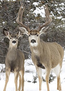
The mule deer is a deer indigenous to western North America; it is named for its ears, which are large like those of the mule. The several subspecies include the black-tailed deer.

Elk Large antlered species of deer from North America and east Asia

The elk or wapiti is one of the largest species within the deer family, Cervidae, and one of the largest terrestrial mammals in North America and Northeast Asia. This animal should not be confused with the still larger moose to which the name "elk" applies in British English and in reference to populations in Eurasia.

See also

Related Research Articles

Sandy River (Oregon) tributary of the Columbia River in northwestern Oregon in the United States

The Sandy River is a 56-mile (90 km) tributary of the Columbia River in northwestern Oregon in the United States. The Sandy joins the Columbia about 14 miles (23 km) upstream of Portland.

Clackamas River tributary of the Willamette River in Oregon

The Clackamas River is an approximately 83-mile (134 km) tributary of the Willamette River in northwestern Oregon, in the United States. Draining an area of about 940 square miles (2,435 km2), the Clackamas flows through mostly forested and rugged mountainous terrain in its upper reaches, and passes agricultural and urban areas in its lower third. The river rises in eastern Marion County, about 55 miles (89 km) east-southeast of Salem. The headwaters are on the slopes of Olallie Butte in the Mount Hood National Forest, about 10 miles (16 km) north of Mount Jefferson, at an elevation of 4,909 feet (1,496 m) in the Cascade Range. The Clackamas flows briefly north and then flows northwest through the mountains, passing through North Fork Reservoir and Estacada. It then emerges from the mountains southeast of Portland. It joins the Willamette near Oregon City and forms the boundary between Oregon City and Gladstone.

Salmon River (Idaho) river in Idaho in the Northwestern United States

The Salmon River is located in Idaho in the northwestern United States. The Salmon is also known as "The River of No Return". It flows for 425 miles (685 km) through central Idaho, draining a rugged, thinly populated watershed of 14,000 square miles (36,000 km2) and dropping more than 7,000 feet (2,100 m) between its headwaters, near Galena Summit above the Sawtooth Valley in the Sawtooth National Recreation Area, and its confluence with the Snake River. Measured at White Bird, its average discharge is 11,060 cubic feet per second. It is one of the largest rivers in the continental United States without a single dam on its mainstem.

Elk River (Oregon) river in southwestern Oregon in the United States

The Elk River is in southwestern Oregon in the United States. About 29 miles (47 km) long, the river drains a remote 92-square-mile (240 km2) area of the Coast Range into the Pacific Ocean.

Donner und Blitzen River river in the United States of America

The Donner und Blitzen River is a river on the eastern Oregon high desert which drains a relatively arid basin, the southern portion of Harney Basin, from roughly 20 to 80 miles south-southeast of Burns including Malheur National Wildlife Refuge. Though much of its course is marsh, it offers scenic glaciated canyons, unique ecosystems, and exceptional wild trout fisheries. Named by soldiers of German origin, the Donner und Blitzen River translates as "thunder and lightning". The name usually brings to mind two of Santa Claus' reindeer, but the river is named for a thunderstorm the soldiers experienced as they crossed the river; dry lightning is an almost daily occurrence in the region during certain times of the year.

Crooked River (Oregon) tributary of the Deschutes River in the U.S. state of Oregon

The Crooked River is a tributary, 125 miles (201 km) long, of the Deschutes River in the U.S. state of Oregon. The river begins at the confluence of the South Fork Crooked River and Beaver Creek. Of the two tributaries, the South Fork Crooked River is the larger and is sometimes considered part of the Crooked River proper. A variant name of the South Fork Crooked River is simply "Crooked River". The Deschutes River flows north into the Columbia River.

South Fork John Day River river in the United States of America

The South Fork John Day River is a 60-mile (97 km) tributary of the John Day River in the U.S. state of Oregon. It begins in the Malheur National Forest in Harney County about 25 miles (40 km) north-northwest of Burns and flows generally north to Dayville, where it meets the main stem of the John Day River. Along the way, the stream passes through the abandoned town of Izee. Black Canyon Wilderness in the Ochoco National Forest lies within the river's drainage basin.

Middle Fork John Day River river in the United States of America

The Middle Fork John Day River is a 73-mile (117 km) tributary of the North Fork John Day River in the U.S. state of Oregon. It originates in the Blue Mountains of northeast Oregon in the Malheur National Forest near Austin and flows generally west to the North Fork about 18 miles (29 km) above Monument. The Middle Fork drainage basin covers about 806 square miles (2,090 km2).

Wenaha River river in the United States of America

The Wenaha River is a tributary of the Grande Ronde River, about 22 miles (35 km) long, in the U.S. state of Oregon. The river begins at the confluence of its north and south forks in the Blue Mountains and flows east through the Wenaha–Tucannon Wilderness to meet the larger river at the small settlement of Troy. A designated Wild and Scenic River for its entire length, the stream flows wholly within Wallowa County.

Little Butte Creek river in the United States of America

Little Butte Creek is a 17-mile-long (27 km) tributary of the Rogue River in the U.S. state of Oregon. Its drainage basin consists of approximately 354 square miles (917 km2) of Jackson County and another 19 square miles (49 km2) of Klamath County. Its two forks, the North Fork and the South Fork, both begin high in the Cascade Range near Mount McLoughlin and Brown Mountain. They both flow generally west until they meet near Lake Creek. The main stem continues west, flowing through the communities of Brownsboro, Eagle Point, and White City, before finally emptying into the Rogue River about 3 miles (5 km) southwest of Eagle Point.

North Fork Malheur River river in the United States of America

The North Fork Malheur River is a 59-mile (95 km) tributary of the Malheur River in eastern Oregon in the United States. Rising in Big Cow Burn in the Blue Mountains, it flows generally south to join the larger river at Juntura. The upper 25.5 miles (41.0 km) of the river have been designated Wild and Scenic. This part of the river basin offers camping, hiking, and fishing opportunities in a remote forest setting. The lower river passes through Beulah Reservoir, which stores water for irrigation and has facilities for boaters.

South Fork Coquille River river in the United States of America

The South Fork Coquille River is the longest tributary of the Coquille River in coastal Oregon in the United States. From its headwaters in the Southern Oregon Coast Range, the river flows northwest to join the North Fork Coquille River at Myrtle Point, forming the main stem Coquille. The South Fork is about 63 miles (101 km) long, and its watershed drains roughly 288 square miles (750 km2) of rural Coos County.

West Little Owyhee River river in the United States of America

West Little Owyhee River is a 63.1-mile-long (101.5 km) tributary of the Owyhee River in the U.S. state of Oregon. The source of the river is at an elevation of 6,508 feet (1,984 m) near McDermitt, while the mouth is at an elevation of 4,373 feet (1,333 m) in the Owyhee Desert. West Little Owyhee River has a 310-square-mile (800 km2) watershed.

Roaring River (Clackamas River tributary)

Roaring River is a 13.7-mile (22.0 km) tributary of the Clackamas River in Clackamas County, Oregon. Beginning near Signal Buttes on the western flank of the Cascade Range, the river flows generally west through parts of Mount Hood National Forest to meet the larger river 44 miles (71 km) from its mouth on the Willamette River.

North Fork Owyhee River river in the United States of America

The North Fork Owyhee River is a tributary, about 30 miles (48 km) long, of the Owyhee River in Malheur County, Oregon, and Owyhee County, Idaho, in the United States. It begins on the east flank of the Owyhee Mountains in Idaho and flows generally southwest to meet the main stem at Three Forks, Oregon, 161 miles (259 km) above the confluence of the larger river with the Snake River.

North Fork Smith River (California) river in the United States

The North Fork Smith River is 28-mile (45 km) tributary of the Smith River that begins in the U.S. state of Oregon and ends in the U.S. state of California. Arising near Chetco Peak in the Klamath Mountains, it flows generally south to meet the Middle Fork Smith River at Gasquet, California. The combined streams form the Smith River.

Middle Fork Coquille River river in the United States of America

The Middle Fork Coquille River is a tributary, about 40 miles (64 km) long, of the South Fork Coquille River in the U.S. state of Oregon. It begins near Camas Mountain in Douglas County in the Southern Oregon Coast Range. It flows generally south, bypassing the community of Camas Valley while passing through the valley of the same name, then curves west and north to Remote in Coos County. The Middle Fork then flows generally west, passes by the small community of Bridge, and meets the South Fork near Myrtle Point. The confluence with the South Fork is 41 miles (66 km) by water to where the main stem of the Coquille River enters the Pacific Ocean at Bandon.

References

  1. 1 2 3 "North Fork John Day River". Geographic Names Information System (GNIS). United States Geological Survey (USGS). November 28, 1980. Retrieved September 1, 2008.
  2. Source elevation derived from Google Earth search using GNIS source coordinates.
  3. Length from mouth to Camas Creek. "Online Topographic Maps from the United States Geological Survey". TopoQuest. Retrieved September 1, 2008.
  4. Length from Camas Creek to source. "North Fork John Day River, Oregon". Public Lands Information Center. Retrieved September 1, 2008.
  5. 1 2 "Water-Data Report 2013: 14046000 North Fork John Day River at Monument, OR" (pdf). United States Geological Survey (USGS). 2014. Retrieved September 24, 2014.
  6. Macy, Tom; James, Gary (2000). "North Fork John Day River Basin Anadromous Fish Enhancement Project" (pdf). Bonneville Power Administration. Retrieved September 3, 2008.
  7. 1 2 "John Day River (North Fork), Oregon". National Wild and Scenic Rivers System. Retrieved September 24, 2014.