
Marion County is one of the 36 counties in the U.S. state of Oregon. The population was 345,920 at the 2020 census, making it the 5th most populous county in Oregon. The county seat is Salem, which is also the state capital of Oregon. The county was originally named the Champooick District, after Champoeg, a meeting place on the Willamette River. On September 3, 1849, the territorial legislature renamed it in honor of Francis Marion, a Continental Army general from South Carolina who served in the American Revolutionary War. Marion County is part of the Salem, OR Metropolitan Statistical Area, which is also included in the Portland-Vancouver-Salem, OR-WA Combined Statistical Area. It is located in the Willamette Valley.

The Portland metropolitan area is a metro area with its core in the U.S. states of Oregon and Washington. It has 5 principal cities the largest being Portland, Oregon. The U.S. Office of Management and Budget (OMB) identifies it as the Portland–Vancouver–Hillsboro, OR–WA Metropolitan Statistical Area, a metropolitan statistical area used by the United States Census Bureau (USCB) and other entities. The OMB defines the area as comprising Clackamas, Columbia, Multnomah, Washington, and Yamhill Counties in Oregon, and Clark and Skamania Counties in Washington. The area had a population of 2,512,859 at the 2020 census, an increase of over 12% since 2010.

The Blacksburg-Christiansburg Metropolitan Statistical Area, formerly the Blacksburg-Christiansburg-Radford Metropolitan Statistical Area, is a Metropolitan Statistical Area (MSA) as defined by the United States Office of Management and Budget (OMB) located in the New River Valley of Southwest Virginia. As of the 2020 census, the MSA had a population of 181,863.

The Harrisonburg Metropolitan Statistical Area is a Metropolitan Statistical Area (MSA) in Virginia as defined by the United States Office of Management and Budget (OMB). As of the 2020 census, the MSA had a population of 135,571.

The Lynchburg Metropolitan Statistical Area is a United States Metropolitan Statistical Area (MSA) in the state of Virginia, as defined by the Office of Management and Budget (OMB) as of June 2003. As of the 2000 census, the MSA had a population of 228,616. In 2009 this was estimated to have risen to 247,447; as of 2016, the Lynchburg MSA was estimated to have a population of 260,320, making it the fifth-largest metro area in the state.

The Des Moines metropolitan area, officially known as the Des Moines–West Des Moines, IA Metropolitan Statistical Area (MSA) is located at the confluence of the Des Moines River and the Raccoon River. Des Moines serves as the capital of the U.S. state of Iowa. The metro area consists of six counties in central Iowa: Polk, Dallas, Warren, Madison, Guthrie, and Jasper. The Des Moines–Ames–West Des Moines Combined Statistical Area (CSA) encompasses the separate metropolitan area of Ames, and the separate micropolitan areas of Pella, Boone and Oskaloosa (Mahaska). The Des Moines area is a fast-growing metro area.
The Charleston Metropolitan Statistical Area, as defined by the United States Census Bureau, is an area consisting of three counties in West Virginia, anchored by the city of Charleston. It is the largest metropolitan area entirely within the state of West Virginia. The Huntington Metro Area adds to the Charleston–Huntington, WV-OH-KY CSA and spans three states, while the core county of the Charleston area, Kanawha County, is more populous than the West Virginia portion of the Huntington area.

The Cleveland, Tennessee Metropolitan Statistical Area, as defined by the United States Census Bureau, is an area consisting of two counties in southeast Tennessee – Bradley and Polk – anchored by the city of Cleveland. As of the 2020 United States census, the MSA had a population of 126,164. The MSA is also part of the Chattanooga Combined Statistical Area. The MSA was first designated in June 2003. Geographically, this metropolitan area is mostly coexistant with the Ocoee Region, a historical and cultural name that reflects the heritage of the area.

The Glens Falls Metropolitan Statistical Area, as defined by the United States Census Bureau, is an area consisting of two counties in Upstate New York, anchored by the city of Glens Falls. It is considered to be a part of the greater Capital District. As of the 2010 census, the MSA had a population of 128,942.

The United States Census Bureau defines the Rochester, Minnesota Metropolitan Statistical Area (MSA) as an area consisting of five counties in southeast Minnesota, anchored by the city of Rochester. As of 2018, the US Census Bureau estimates that the Rochester metropolitan statistical area has a population of 221,587. The Rochester–Austin combined statistical area has a population of 259,813 as of 2018.

The Morgantown Metropolitan Statistical Area, as defined by the United States Census Bureau, is an area consisting of two counties in North-Central West Virginia, anchored by the city of Morgantown. As of the 2020 census, the MSA had a population of 140,038.
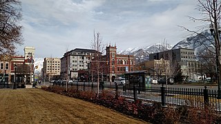
The Provo–Orem, UT Metropolitan Statistical Area, as defined by the United States Office of Management and Budget, is an area consisting of two counties in Utah, anchored by the cities of Provo and Orem. As of the 2020 census, the MSA had a population of 671,185.

The Salt Lake City metropolitan area is the metropolitan area centered on the city of Salt Lake City, Utah. The Office of Management and Budget and the United States Census Bureau currently define the Salt Lake City, Utah Metropolitan Statistical Area (MSA) as comprising two counties: Salt Lake and Tooele. As of the 2020 census, the MSA had a population of 1,257,936. The Salt Lake City Metropolitan Area and the Ogden-Clearfield Metropolitan Area were a single metropolitan area known as the Salt Lake City-Ogden Metropolitan Area until being separated in 2005.

The Rockford Metropolitan Statistical Area, as defined by the United States Census Bureau, is an area consisting of four counties in north-central Illinois, anchored by the city of Rockford. As of the 2010 census, the MSA had a population of 349,431. The Rockford MSA abuts the southern portions of the Janesville-Beloit MSA and the Chicago MSA. It forms the main part of the larger Rockford–Freeport–Rochelle Combined Statistical Area.

The Montgomery, Alabama Metropolitan Statistical Area is a metropolitan area in central Alabama. As of 2020, the MSA had a population of 386,047, ranking it 142nd among United States Metropolitan Statistical Areas. That number is up +3.07% from the 2010 census number of 374,536.
The Wichita, Kansas Metropolitan Statistical Area, as defined by the United States Office of Management and Budget, is an area consisting of four counties in south central Kansas, its only principal city is Wichita and its only central county is Sedgwick County. As of the 2023 American Community Survey, the MSA had a population of 652,939.

The Columbus metropolitan area, officially the Columbus metropolitan statistical area, and colloquially known as the Chattahoochee Valley, is a metropolitan statistical area consisting of six counties in the U.S. state of Georgia and one county in Alabama, anchored by the city of Columbus.

The Canton–Massillon Metropolitan Statistical Area, as defined by the United States Census Bureau, is an area consisting of two counties in Northeast Ohio, anchored by the cities of Canton and Massillon. As of the 2020 census, the MSA had a population of 401,574. The MSA is also part of the Cleveland–Akron–Canton, OH Combined Statistical Area, which had a population of 3,633,962 in 2020, making it the largest CSA in Ohio.

The Bloomsburg–Berwick Metropolitan Statistical Area (MSA), as defined by the United States Census Bureau, is an area consisting of two counties in Pennsylvania, anchored by the town of Bloomsburg and the borough of Berwick. As of the 2010 census, the MSA had a population of 85,562.
The Kokomo Metropolitan Statistical Area, as defined by the United States Census Bureau, is an area consisting of Howard County in Indiana. Howard County had a population estimate of 83,831 in 2023. Kokomo is also the principal city of the area known as North Central Indiana, the area around Kokomo with economic ties. The six county area including Cass, Clinton, Fulton, Howard, Miami, and Tipton counties had population of 228,331 people in 2010.
