List of beaches in Oregon

Last updated

Map all coordinates using: OpenStreetMap  
Download coordinates as: KML

List of beaches in Oregon enumerates all landmarks designated as a beach in the U.S. state of Oregon.

Cannon Beach facing south, with Haystack Rock on the right CannonBeachOR.jpg
Cannon Beach facing south, with Haystack Rock on the right
Haystack Rock at Cannon Beach Cannon Beach 02.jpg
Haystack Rock at Cannon Beach
South view of Moolack Beach. The Yaquina Head Light is visible Moolack Beach sunset southward 2007-10-26.jpeg
South view of Moolack Beach. The Yaquina Head Light is visible
Cliffs beside a beach on the Oregon Coast Cliff Oregon coast.jpg
Cliffs beside a beach on the Oregon Coast
Rocks just off the Oregon Coast Oregon Coast 2.jpg
Rocks just off the Oregon Coast
Beach north of Cape Sabastian near Gold Beach Beach north of Cape Sebastian.jpg
Beach north of Cape Sabastian near Gold Beach
Lone Ranch Beach seen towards south Lone Ranch Beach.JPG
Lone Ranch Beach seen towards south
Bandon Beach Bandon Oregon beach 2.jpeg
Bandon Beach
NameElevationCoordinateUSGS map GNIS ID
Agate Beach (Cape Arago, Oregon) 13 ft (4.0 m) 43°15′11″N124°23′14″W / 43.25306°N 124.38722°W / 43.25306; -124.38722 (Agate Beach (Cape Arago, Oregon)) Cape Arago 1116782
Agate Beach (Tillamook, Oregon) 13 ft (4.0 m) 45°27′57″N123°58′28″W / 45.46583°N 123.97444°W / 45.46583; -123.97444 (Agate Beach (Tillamook, Oregon)) Netarts 1135119
Agate Beach (Port Orford, Oregon) 23 ft (7.0 m) 42°44′52″N124°30′49″W / 42.74778°N 124.51361°W / 42.74778; -124.51361 (Agate Beach (Port Orford, Oregon)) Port Orford OE W 1135158
Agate Beach (Gold Beach, Oregon) 3 ft (0.91 m) 42°28′14″N124°25′19″W / 42.47056°N 124.42194°W / 42.47056; -124.42194 (Agate Beach (Gold Beach, Oregon)) Gold Beach 1154893
Arcadia Beach (Oregon) 23 ft (7.0 m) 45°50′21″N123°57′40″W / 45.83917°N 123.96111°W / 45.83917; -123.96111 (Arcadia Beach (Oregon)) Arch Cape 1117027
Arizona Beach (Oregon) 7 ft (2.1 m) 42°36′54″N124°23′59″W / 42.61500°N 124.39972°W / 42.61500; -124.39972 (Arizona Beach (Oregon)) Ophir 1135018
Baker Beach (Oregon) 10 ft (3.0 m) 44°04′34″N124°07′36″W / 44.07611°N 124.12667°W / 44.07611; -124.12667 (Baker Beach (Oregon)) Mercer Lake OE W 1154782
Bandon Beach (Coos County, Oregon) 0 ft (0 m) 43°06′37″N124°26′12″W / 43.11028°N 124.43667°W / 43.11028; -124.43667 (Bandon Beach (Coos County, Oregon)) Bandon 1161647
Barley Beach (Oregon) 36 ft (11 m) 42°27′24″N124°25′19″W / 42.45667°N 124.42194°W / 42.45667; -124.42194 (Barley Beach (Oregon)) Gold Beach 1154890
Bastendorff Beach 0 ft (0 m) 43°20′43″N124°20′54″W / 43.34528°N 124.34833°W / 43.34528; -124.34833 (Bastendorff Beach) Charleston 1161264
Broughton Beach 10 ft (3.0 m) 45°35′59″N122°36′19″W / 45.59972°N 122.60528°W / 45.59972; -122.60528 (Broughton Beach (Oregon)) Mount Tabor 1132082
Cannon Beach, Oregon 20 ft (6.1 m) 45°52′54″N123°57′51″W / 45.88167°N 123.96417°W / 45.88167; -123.96417 (Cannon Beach (Oregon)) Tillamook Head 1118563
Chapman Beach 46 ft (14 m) 45°54′12″N123°57′50″W / 45.90333°N 123.96389°W / 45.90333; -123.96389 (Chapman Beach (Oregon)) Tillamook Head 1118825
Cottonwood Beach (Oregon) 7 ft (2.1 m) 46°04′44″N122°54′19″W / 46.07889°N 122.90528°W / 46.07889; -122.90528 (Cottonwood Beach (Oregon)) Rainier 1162770
Cove Beach, Oregon 26 ft (7.9 m) 45°47′17″N123°58′05″W / 45.78806°N 123.96806°W / 45.78806; -123.96806 (Cove Beach (Oregon)) Arch Cape 1119403
Crescent Beach (Oregon) 46 ft (14 m) 45°54′52″N123°58′13″W / 45.91444°N 123.97028°W / 45.91444; -123.97028 (Crescent Beach (Oregon)) Tillamook Head 1119533
Dibblees Beach 3 ft (0.91 m) 46°07′01″N122°59′19″W / 46.11694°N 122.98861°W / 46.11694; -122.98861 (Dibblees Beach) Rainier 1162767
Goble Beach (Oregon) 10 ft (3.0 m) 46°01′09″N122°52′29″W / 46.01917°N 122.87472°W / 46.01917; -122.87472 (Goble Beach (Oregon)) Kalama 1130258
Harris Beach (Oregon) 26 ft (7.9 m) 42°03′51″N124°18′18″W / 42.06417°N 124.30500°W / 42.06417; -124.30500 (Harris Beach (Oregon)) Brookings 1134651
Heceta Beach (Florence, Oregon)39 ft (12 m) 44°02′01″N124°07′48″W / 44.03361°N 124.13000°W / 44.03361; -124.13000 (Heceta Beach (Florence, Oregon)) Florence
Holly Beach (Oregon) 13 ft (4.0 m) 44°28′11″N124°04′54″W / 44.46972°N 124.08167°W / 44.46972; -124.08167 (Holly Beach (Oregon)) Waldport 1154807
Indian Beach (Oregon) 33 ft (10 m) 45°55′40″N123°58′40″W / 45.92778°N 123.97778°W / 45.92778; -123.97778 (Indian Beach (Oregon)) Tillamook Head 1122197
Jones Beach (Oregon) 7 ft (2.1 m) 46°08′21″N123°18′34″W / 46.13917°N 123.30944°W / 46.13917; -123.30944 (Jones Beach (Oregon)) Nassa Point 1135010
Kiwanda Beach 46 ft (14 m) 45°09′05″N123°58′27″W / 45.15139°N 123.97417°W / 45.15139; -123.97417 (Kiwanda Beach) Nestucca Bay 1163088
Koberg Beach 79 ft (24 m) 45°41′57″N121°28′03″W / 45.69917°N 121.46750°W / 45.69917; -121.46750 (Koberg Beach) White Salmon 1129632
Lighthouse Beach (Oregon) 30 ft (9.1 m) 43°20′20″N124°21′59″W / 43.33889°N 124.36639°W / 43.33889; -124.36639 (Lighthouse Beach (Oregon)) Charleston 1161417
Lone Ranch Beach 3 ft (0.91 m) 42°05′54″N124°20′34″W / 42.09833°N 124.34278°W / 42.09833; -124.34278 (Lone Ranch Beach) Brookings 1134653
Lyons Beach (Oregon) 13 ft (4.0 m) 45°49′59″N122°47′49″W / 45.83306°N 122.79694°W / 45.83306; -122.79694 (Lyons Beach (Oregon)) Saint Helens 1166955
McNary Beach (Oregon) 344 ft (105 m) 45°55′44″N119°16′54″W / 45.92889°N 119.28167°W / 45.92889; -119.28167 (McNary Beach (Oregon)) Umatilla 1129673
Merchants Beach (Coos County, Oregon) 0 ft (0 m) 43°14′13″N124°23′31″W / 43.23694°N 124.39194°W / 43.23694; -124.39194 (Merchants Beach (Coos County, Oregon)) Bullards 1161436
Moolack Beach 0 ft (0 m) 44°41′59″N124°03′55″W / 44.69972°N 124.06528°W / 44.69972; -124.06528 (Moolack Beach) Newport North 1124315
Nehalem Beach 23 ft (7.0 m) 45°39′59″N123°56′14″W / 45.66639°N 123.93722°W / 45.66639; -123.93722 (Nehalem Beach) Nehalem 1158928
Neskowin Beach 7 ft (2.1 m) 45°06′04″N123°59′09″W / 45.10111°N 123.98583°W / 45.10111; -123.98583 (Neskowin Beach) Neskowin 1153469
North Beach (Oregon) 23 ft (7.0 m) 43°23′05″N124°18′59″W / 43.38472°N 124.31639°W / 43.38472; -124.31639 (North Beach (Oregon)) Empire 1161459
Nye Beach 23 ft (7.0 m) 44°38′32″N124°03′44″W / 44.64222°N 124.06222°W / 44.64222; -124.06222 (Nye Beach) Newport North 1124867
Ona Beach 0 ft (0 m) 44°31′34″N124°04′34″W / 44.52611°N 124.07611°W / 44.52611; -124.07611 (Ona Beach) Newport South 1154766
Ophir Beach 82 ft (25 m) 42°32′59″N124°23′39″W / 42.54972°N 124.39417°W / 42.54972; -124.39417 (Ophir Beach) Ophir 1154674
Red Mill Beach (Oregon) 3 ft (0.91 m) 46°05′14″N122°55′19″W / 46.08722°N 122.92194°W / 46.08722; -122.92194 (Red Mill Beach (Oregon)) Rainier 1162771
Sacchi Beach 16 ft (4.9 m) 43°15′51″N124°23′01″W / 43.26417°N 124.38361°W / 43.26417; -124.38361 (Sacchi Beach) Cape Arago 1126400
San Salvador Beach (Oregon) 79 ft (24 m) 45°13′18″N123°01′37″W / 45.22167°N 123.02694°W / 45.22167; -123.02694 (San Salvador Beach (Oregon)) Dayton 1126547
Short Beach (Oregon) 115 ft (35 m) 45°28′29″N123°58′06″W / 45.47472°N 123.96833°W / 45.47472; -123.96833 (Short Beach (Oregon)) Netarts 1149423
Short Sand Beach 59 ft (18 m) 45°45′45″N123°58′02″W / 45.76250°N 123.96722°W / 45.76250; -123.96722 (Short Sand Beach) Arch Cape 1126922
Sixes Beach (Oregon) 0 ft (0 m) 42°51′04″N124°32′44″W / 42.85111°N 124.54556°W / 42.85111; -124.54556 (Sixes Beach (Oregon)) Cape Blanco 1132532
Sundial Beach (Oregon) 20 ft (6.1 m) 45°34′00″N122°24′18″W / 45.56667°N 122.40500°W / 45.56667; -122.40500 (Sundial Beach (Oregon)) Camas 1158512
Sunset Beach (Gearhart, Oregon) 20 ft (6.1 m) 46°05′19″N123°56′09″W / 46.08861°N 123.93583°W / 46.08861; -123.93583 (Sunset Beach (Gearhart, Oregon)) Gearhart 1127744
Sunset Beach (Nehalem, Oregon) 33 ft (10 m) 45°41′38″N123°56′20″W / 45.69389°N 123.93889°W / 45.69389; -123.93889 (Sunset Beach (Nehalem, Oregon)) Nehalem 1135944
Sunset Beach (Tillamook, Oregon) 108 ft (33 m) 45°58′29″N123°56′49″W / 45.97472°N 123.94694°W / 45.97472; -123.94694 (Sunset Beach (Tillamook, Oregon)) Tillamook Head 1162087
Wakeman Beach (Oregon) 13 ft (4.0 m) 42°29′14″N124°25′14″W / 42.48722°N 124.42056°W / 42.48722; -124.42056 (Wakeman Beach (Oregon)) Gold Beach 1154894
Westport Beach (Oregon) 7 ft (2.1 m) 46°08′39″N123°22′44″W / 46.14417°N 123.37889°W / 46.14417; -123.37889 (Westport Beach (Oregon)) Cathlamet 1160974
Whisky Run Beach (Oregon) 10 ft (3.0 m) 43°12′42″N124°23′42″W / 43.21167°N 124.39500°W / 43.21167; -124.39500 (Whisky Run Beach (Oregon)) Bullards 1161587
Wilson Beach (Oregon) 43 ft (13 m) 45°25′41″N123°56′16″W / 45.42806°N 123.93778°W / 45.42806; -123.93778 (Wilson Beach (Oregon)) Netarts 1152448

See also

Related Research Articles

Oregon Coast Coastal region of the U.S. state of Oregon

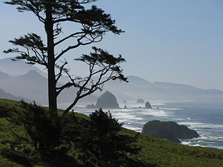
The Oregon Coast is a coastal region of the U.S. state of Oregon. It is bordered by the Pacific Ocean to its west and the Oregon Coast Range to the east, and stretches approximately 362 miles (583 km) from the California state border in the south to the Columbia River in the north. The region is not a specific geological, environmental, or political entity, and includes the Columbia River Estuary.

Rooster Rock State Park State park in the U.S. state of Oregon

Rooster Rock State Park is a state park located east of Corbett, in the U.S. state of Oregon. One of the features of the park is Rooster Rock, a column of basalt forming a natural obelisk, which stands near the south side of the Columbia River Gorge, in the lee of Crown Point. The park is administered by the Oregon Parks and Recreation Department.

Ecola State Park

Ecola State Park is a state park located approximately 3 miles north of Cannon Beach in Clatsop County in the U.S. state of Oregon on the Oregon Coast. It is administered by the Oregon Parks and Recreation Department.

Harris Beach State Park

Harris Beach State Park is an Oregon State Park located on US Highway 101, north of Brookings. The day-use area offers a restroom and picnic area with tables, and the campground has RV sites, yurts and tent sites available year-round.

Hug Point State Recreation Site

Hug Point State Recreation Site is a state park on the northern Oregon Coast in the U.S. state of Oregon. Administered by the Oregon Parks and Recreation Department, the park is open to the public and is fee-free. Amenities at the park, which is 5 miles (8.0 km) south of Cannon Beach along U.S. Route 101, include picnicking, fishing, and a Pacific Ocean beach.

Agate Beach State Recreation Site

Agate Beach State Recreation Site is a state park between Newport and Agate Beach in Lincoln County in the U.S. state of Oregon. It is administered by the Oregon Parks and Recreation Department.

Bullards Beach State Park

Bullards Beach State Park is a state park in the U.S. state of Oregon, administered by the Oregon Parks and Recreation Department.

Del Rey Beach State Recreation Site

Del Rey Beach State Recreation Site is a state park in the U.S. state of Oregon, administered by the Oregon Parks and Recreation Department.

Driftwood Beach State Recreation Site

Driftwood Beach State Recreation Site is a state park administered by the Oregon Parks and Recreation Department in the U.S. state of Oregon. Located 3 miles (5 km) north of Waldport along the Pacific Ocean, the park offers beach access, picnicking, and fishing in a setting of shore pines and sand. It is fee-free and open year-round.

Gleneden Beach State Recreation Site State park in the U.S. state of Oregon

Gleneden Beach State Recreation Site is a state park administered by the Oregon Parks and Recreation Department in the U.S. state of Oregon. Located along the Pacific Ocean 7 miles (11 km) south of Lincoln City, it offers public beach access, picnicking, and fishing in a setting of shore pines, sandstone bluffs, and sand. The park is fee-free.

Koberg Beach State Recreation Site

Koberg Beach State Recreation Site is a state park in Hood River County, Oregon United States, administered by the Oregon Parks and Recreation Department. The park offers a wayside rest area for west bound traffic on Interstate 84.

Manhattan Beach State Recreation Site

Manhattan Beach State Recreation Site is a state park in the U.S. state of Oregon. Administered by the Oregon Parks and Recreation Department, the park is open to the public and is fee-free. Amenities at the park, which is 2 miles (3 km) north of Rockaway Beach along U.S. Route 101, include picnicking, fishing, and a Pacific Ocean beach.

Neskowin Beach State Recreation Site

Neskowin Beach State Recreation Site is a state park in Tillamook County, Oregon, United States, administered by the Oregon Parks and Recreation Department.

Oceanside Beach State Recreation Site

Oceanside Beach State Recreation Site is a state park in the U.S. state of Oregon. Administered by the Oregon Parks and Recreation Department, the park is open to the public and is fee-free. Amenities at the site, in the unincorporated community of Oceanside, include picnicking, wildlife watching, fishing, windsurfing, and kite flying. It is not uncommon to see paraglider pilots land at the beach on Southwest wind days during the fall, winter and spring. Beachcombing is popular in summer, and agate hunting is best in winter, when ocean currents remove sand. Oceanside is about 11 miles (18 km) west of Tillamook off U.S. Route 101.

South Beach State Park

South Beach State Park is a state park in the U.S. state of Oregon, administered by the Oregon Parks and Recreation Department. It is near the unincorporated community of South Beach.

Stonefield Beach State Recreation Site

Stonefield Beach State Recreation Site is a state park in the U.S. state of Oregon, administered by the Oregon Parks and Recreation Department.

Sunset Beach State Recreation Site is a state park in Clatsop County, Oregon, United States, administered by the Oregon Parks and Recreation Department. The park comprises 120 acres (49 ha) along the Pacific Ocean on the Clatsop Plains.

Tolovana Beach State Recreation Site is a state park in the U.S. state of Oregon, administered by the Oregon Parks and Recreation Department.

Lone Ranch Beach

Lone Ranch Beach is a beach administered by the Oregon Parks and Recreation Department, as it is part of the Samuel H. Boardman State Scenic Corridor.

Brian Booth State Park This Place is a natural park and is a recreational area

Brian Booth State Park is a coastal recreational area located near Seal Rock, Lincoln County, Oregon United States, administered by the Oregon Parks and Recreation Department.. It consists of two major portions: Ona Beach State Park and Beaver Creek State Natural Area, which were merged in 2013. The park has beach access, kayaking, and hiking trails. The park is 886.32 acres and has an annual attendance of 247,772 people. Ona is known as a Chinook Jargon word for razor clam.