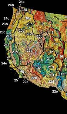
In the context of physical geography, the Intermontane Plateaus is one of eight physiographic regions of the contiguous United States. The region consists mostly of plateaus and mountain ranges lying between the Rocky Mountains on the east and the Cascade and Sierra Nevada Mountains on the west. It is subdivided into three physiographic provinces: the Columbia Plateau in the north, the Basin and Range Province in the central and southwestern portions, and the Colorado Plateau in the southeast. In turn, each of these provinces are each subdivided into a number of physiographic sections.

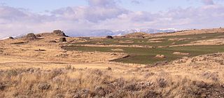
The Basin and Range Province is a vast physiographic region covering much of the inland Western United States and northwestern Mexico. It is defined by unique basin and range topography, characterized by abrupt changes in elevation, alternating between narrow faulted mountain chains and flat arid valleys or basins. The physiography of the province is the result of tectonic extension that began around 17 million years ago in the early Miocene epoch.
In geology, the slab gap hypothesis is one of the explanations put forward to explain several instances of crustal extension that occur inland near former subduction zones.

The Yellowstone Caldera, sometimes referred to as the Yellowstone Supervolcano, is a volcanic caldera and supervolcano in Yellowstone National Park in the Western United States. The caldera and most of the park are located in the northwest corner of Wyoming. The caldera measures 43 by 28 miles, and postcaldera lavas spill out a significant distance beyond the caldera proper.

The richly textured landscape of the United States is a product of the dueling forces of plate tectonics, weathering and erosion. Over the 4.5 billion-year history of the Earth, tectonic upheavals and colliding plates have raised great mountain ranges while the forces of erosion and weathering worked to tear them down. Even after many millions of years, records of Earth's great upheavals remain imprinted as textural variations and surface patterns that define distinctive landscapes or provinces.

A flood basalt is the result of a giant volcanic eruption or series of eruptions that covers large stretches of land or the ocean floor with basalt lava. Many flood basalts have been attributed to the onset of a hotspot reaching the surface of the Earth via a mantle plume. Flood basalt provinces such as the Deccan Traps of India are often called traps, after the Swedish word trappa, due to the characteristic stairstep geomorphology of many associated landscapes.

A large igneous province (LIP) is an extremely large accumulation of igneous rocks, including intrusive and extrusive, arising when magma travels through the crust towards the surface. The formation of LIPs is variously attributed to mantle plumes or to processes associated with divergent plate tectonics. The formation of some of the LIPs in the past 500 million years coincide in time with mass extinctions and rapid climatic changes, which has led to numerous hypotheses about causal relationships. LIPs are fundamentally different from any other currently active volcanoes or volcanic systems.

The Yellowstone hotspot is a volcanic hotspot in the United States responsible for large scale volcanism in Idaho, Montana, Nevada, Oregon, and Wyoming, formed as the North American tectonic plate moved over it. It formed the eastern Snake River Plain through a succession of caldera-forming eruptions. The resulting calderas include the Island Park Caldera, Henry's Fork Caldera, and the Bruneau-Jarbidge caldera. The hotspot currently lies under the Yellowstone Caldera. The hotspot's most recent caldera-forming supereruption, known as the Lava Creek Eruption, took place 640,000 years ago and created the Lava Creek Tuff, and the most recent Yellowstone Caldera. The Yellowstone hotspot is one of a few volcanic hotspots underlying the North American tectonic plate; another example is the Anahim hotspot.

The Northern Cordilleran Volcanic Province (NCVP), formerly known as the Stikine Volcanic Belt, is a geologic province defined by the occurrence of Miocene to Holocene volcanoes in the Pacific Northwest of North America. This belt of volcanoes extends roughly north-northwest from northwestern British Columbia and the Alaska Panhandle through Yukon to the Southeast Fairbanks Census Area of far eastern Alaska, in a corridor hundreds of kilometres wide. It is the most recently defined volcanic province in the Western Cordillera. It has formed due to extensional cracking of the North American continent—similar to other on-land extensional volcanic zones, including the Basin and Range Province and the East African Rift. Although taking its name from the Western Cordillera, this term is a geologic grouping rather than a geographic one. The southmost part of the NCVP has more, and larger, volcanoes than does the rest of the NCVP; further north it is less clearly delineated, describing a large arch that sways westward through central Yukon.

The Columbia River Basalt Group is the youngest, smallest and one of the best-preserved continental flood basalt provinces on Earth, covering over 210,000 km2 (81,000 sq mi) mainly eastern Oregon and Washington, western Idaho, and part of northern Nevada. The basalt group includes the Steens and Picture Gorge basalt formations.
Moses Coulee is a canyon in the Waterville plateau region of Douglas County, Washington. Moses Coulee is the second-largest and westernmost canyon of the Channeled Scablands, located about 30 kilometres (19 mi) to the west of the larger Grand Coulee. This water channel is now dry, but during glacial periods, large outburst floods with discharges greater than 600,000 m3/s (21,000,000 cu ft/s) carved the channel. While it's clear that megafloods from Glacial Lake Missoula passed through and contributed to the erosion of Moses Coulee, the origins of the coulee are less clear. Some researchers propose that floods from glacial Lake Missoula formed Moses Coulee, while others suggest that subglacial floods from the Okanogan Lobe incised the canyon. The mouth of Moses Coulee discharges into the Columbia River.
The Withrow Moraine and Jameson Lake Drumlin Field is a National Park Service–designated privately owned National Natural Landmark located in Douglas County, Washington state, United States. Withrow Moraine is the only Ice Age terminal moraine on the Waterville Plateau section of the Columbia Plateau. The drumlin field includes excellent examples of glacially-formed elongated hills.
Volcanic activity is a major part of the geology of Canada and is characterized by many types of volcanic landform, including lava flows, volcanic plateaus, lava domes, cinder cones, stratovolcanoes, shield volcanoes, submarine volcanoes, calderas, diatremes, and maars, along with less common volcanic forms such as tuyas and subglacial mounds.
The Anahim hotspot is a hypothesized hotspot in the Central Interior of British Columbia, Canada. It has been proposed as the candidate source for volcanism in the Anahim Volcanic Belt, a 300 kilometres long chain of volcanoes and other magmatic features that have undergone erosion. This chain extends from the community of Bella Bella in the west to near the small city of Quesnel in the east. While most volcanoes are created by geological activity at tectonic plate boundaries, the Anahim hotspot is located hundreds of kilometres away from the nearest plate boundary.

The geology of the Pacific Northwest includes the composition, structure, physical properties and the processes that shape the Pacific Northwest region of North America. The region is part of the Ring of Fire: the subduction of the Pacific and Farallon Plates under the North American Plate is responsible for many of the area's scenic features as well as some of its hazards, such as volcanoes, earthquakes, and landslides.
The Oregon High Desert is a region of the U.S. state of Oregon located east of the Cascade Range and south of the Blue Mountains, in the central and eastern parts of the state. Divided into a southern region and a northern region, the desert covers most of five Oregon counties and averages 4,000 feet (1,200 m) above sea level. The southwest region is part of the Great Basin and the southeast is the lower Owyhee River watershed. The northern region is part of the Columbia Plateau, where higher levels of rainfall allow the largest industry on private land to be the cultivation of alfalfa and hay. Public land within the region is owned primarily by the Bureau of Land Management, which manages more than 30,000 square miles (78,000 km2) including five rivers designated as Wild and Scenic.

Volcanism of Northern Canada has produced hundreds of volcanic areas and extensive lava formations across Northern Canada. The region's different volcano and lava types originate from different tectonic settings and types of volcanic eruptions, ranging from passive lava eruptions to violent explosive eruptions. Northern Canada has a record of very large volumes of magmatic rock called large igneous provinces. They are represented by deep-level plumbing systems consisting of giant dike swarms, sill provinces and layered intrusions.

The Brothers Fault Zone (BFZ) is the most notable of a set of northwest-trending fault zones including the Eugene–Denio, McLoughlin, and Vale zones that dominate the geological structure of most of Oregon. These are also representative of a regional pattern of generally northwest-striking geological features ranging from Walker Lane on the California–Nevada border to the Olympic–Wallowa Lineament in Washington; these are generally associated with the regional extension and faulting of the Basin and Range Province, of which the BFZ is considered the northern boundary.
The Yakima Fold Belt of south-central Washington, also called the Yakima fold-and-thrust belt, is an area of topographical folds raised by tectonic compression. It is a 14,000 km2 (5,400 sq mi) structural-tectonic sub province of the western Columbia Plateau Province resulting from complex and poorly understood regional tectonics. The folds are associated with geological faults whose seismic risk is of particular concern to the nuclear facilities at the Hanford Nuclear Reservation and major dams on the Columbia and Snake Rivers.

