Power County, Idaho

Last updated

Power County
Power County Courthouse.jpg
Power County Courthouse, American Falls
Power County, Idaho seal.png
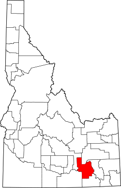
Map of Idaho highlighting Power County.svg
Location within the U.S. state of Idaho
Idaho in United States.svg
Idaho's location within the U.S.
Coordinates: 42°41′N112°50′W / 42.69°N 112.84°W / 42.69; -112.84
CountryFlag of the United States.svg United States
StateFlag of Idaho.svg  Idaho
FoundedJanuary 30, 1913
Named for power plant at the American Falls Dam
Seat American Falls
Largest cityAmerican Falls
Area
  Total
1,443 sq mi (3,740 km2)
  Land1,404 sq mi (3,640 km2)
  Water38 sq mi (100 km2)  2.7%
Population
 (2020)
  Total
7,878
  Density5.5/sq mi (2.1/km2)
Time zone UTC−7 (Mountain)
  Summer (DST) UTC−6 (MDT)
Congressional district 2nd
Website www.co.power.id.us

Power County is a county located in the U.S. state of Idaho. As of the 2020 Census, the county had a population of 7,878. [1] The county seat and largest city is American Falls. [2] The county was created by the Idaho Legislature on January 30, 1913, by a partition of Cassia County. It is named for an early hydroelectric power plant (1902) at the American Falls. [3]

Contents

Geography

According to the U.S. Census Bureau, the county has a total area of 1,443 square miles (3,740 km2), of which 1,404 square miles (3,640 km2) is land and 38 square miles (98 km2) (2.7%) is water. [4]

Adjacent counties

Major highways

National protected areas

Government

Power County's commissioners are: [5]

United States presidential election results for Power County, Idaho [6]
Year Republican Democratic Third party(ies)
No.%No.%No.%
2024 2,14671.04%78525.98%902.98%
2020 2,11668.57%86528.03%1053.40%
2016 1,66660.41%69925.34%39314.25%
2012 1,87064.39%98233.82%521.79%
2008 1,75461.72%1,02736.14%612.15%
2004 2,10571.16%82928.03%240.81%
2000 1,87269.10%75527.87%823.03%
1996 1,50151.12%1,07036.44%36512.43%
1992 1,35245.41%83728.12%78826.47%
1988 1,83861.66%1,09536.73%481.61%
1984 2,29876.50%67822.57%280.93%
1980 2,23571.11%72723.13%1815.76%
1976 1,37449.96%1,28646.76%903.27%
1972 1,40564.45%62528.67%1506.88%
1968 1,22260.26%58228.70%22411.05%
1964 96645.42%1,16154.58%00.00%
1960 1,06552.59%96047.41%00.00%
1956 1,10859.03%76940.97%00.00%
1952 1,30868.45%60331.55%00.00%
1948 87552.05%79547.29%110.65%
1944 89552.77%80147.23%00.00%
1940 95150.45%93149.39%30.16%
1936 70839.07%1,07559.33%291.60%
1932 60334.74%1,12664.86%70.40%
1928 85256.50%65343.30%30.20%
1924 75743.13%31417.89%68438.97%
1920 1,15567.31%56132.69%00.00%
1916 1,02447.41%1,07949.95%572.64%

Demographics

Historical population
CensusPop.Note
1920 5,105
1930 4,457−12.7%
1940 3,965−11.0%
1950 3,9880.6%
1960 4,1113.1%
1970 4,86418.3%
1980 6,84440.7%
1990 7,0863.5%
2000 7,5386.4%
2010 7,8173.7%
2020 7,8780.8%
2023 (est.)8,253 [7] 4.8%
U.S. Decennial Census [8]
1790–1960, [9] 1900–1990, [10]
1990–2000, [11] 2010, [12] 2020 [1]

2000 census

As of the census [13] of 2000, there were 7,538 people, 2,560 households, and 1,968 families living in the county. The population density was 5 people per square mile (1.9 people/km2). There were 2,844 housing units at an average density of 2 units per square mile (0.77 units/km2). The racial makeup of the county was 83.78% White, 0.09% Black or African American, 3.29% Native American, 0.32% Asian, 0.04% Pacific Islander, 11.10% from other races, and 1.38% from two or more races. 21.73% of the population were Hispanic or Latino of any race. 18.0% were of German, 17.6% English and 10.9% American ancestry.

There were 2,560 households, out of which 40.90% had children under the age of 18 living with them, 63.40% were married couples living together, 8.80% had a female householder with no husband present, and 23.10% were non-families. 20.30% of all households were made up of individuals, and 8.80% had someone living alone who was 65 years of age or older. The average household size was 2.92 and the average family size was 3.38.

In the county, the population was spread out, with 33.80% under the age of 18, 8.40% from 18 to 24, 25.40% from 25 to 44, 22.00% from 45 to 64, and 10.40% who were 65 years of age or older. The median age was 32 years. For every 100 females, there were 101.00 males. For every 100 females age 18 and over, there were 99.90 males.

The median income for a household in the county was $32,226, and the median income for a family was $36,685. Males had a median income of $29,676 versus $20,930 for females. The per capita income for the county was $14,007. About 10.80% of families and 16.10% of the population were below the poverty line, including 20.10% of those under age 18 and 12.70% of those age 65 or over.

2010 census

As of the 2010 United States census, there were 7,817 people, 2,641 households, and 2,019 families living in the county. [14] The population density was 5.6 inhabitants per square mile (2.2/km2). There were 2,944 housing units at an average density of 2.1 units per square mile (0.81 units/km2). [15] The racial makeup of the county was 75.1% white, 2.3% American Indian, 0.4% Asian, 0.3% black or African American, 0.1% Pacific islander, 19.5% from other races, and 2.4% from two or more races. Those of Hispanic or Latino origin made up 29.8% of the population. [14] In terms of ancestry, 16.7% were German, 16.7% were English, and 7.2% were American. [16]

Of the 2,641 households, 40.7% had children under the age of 18 living with them, 60.6% were married couples living together, 10.1% had a female householder with no husband present, 23.6% were non-families, and 19.8% of all households were made up of individuals. The average household size was 2.94 and the average family size was 3.39. The median age was 33.2 years. [14]

The median income for a household in the county was $40,843 and the median income for a family was $46,391. Males had a median income of $35,674 versus $29,844 for females. The per capita income for the county was $18,412. About 8.3% of families and 11.1% of the population were below the poverty line, including 13.7% of those under age 18 and 12.3% of those age 65 or over. [17]

Communities

An aerial view of the Power County wind farm in Power County Power County Wind Farm 002.jpg
An aerial view of the Power County wind farm in Power County

Cities

Census-designated place

Unincorporated communities

Education

School districts include: [18]

See also

Related Research Articles

<span class="mw-page-title-main">Adams County, Idaho</span> County in Idaho, United States

Adams County is a rural county in the state of Idaho. As of the 2020 census, the county had a population of 4,379, making it the sixth-least populous county in Idaho. The county seat and largest city is Council. Established in 1911, the county was named for second U.S. President John Adams. Adams County is home to the Brundage Mountain ski area, northeast of New Meadows, and the Little Ski Hill, just west of McCall.

<span class="mw-page-title-main">Pend Oreille County, Washington</span> County in Washington, United States

Pend Oreille County is a county located in the northeast corner of the U.S. state of Washington, along the Canada–US border. As of the 2020 census, the population was 13,401. The county seat and largest city is Newport.

<span class="mw-page-title-main">Washington County, Idaho</span> County in Idaho, United States

Washington County is a county in the U.S. state of Idaho. As of the 2020 census, the population was 10,500. The county seat and largest city is Weiser, with over half of the county's population. The county was established in 1879 when Idaho was a territory and named after U.S. President George Washington.

<span class="mw-page-title-main">Twin Falls County, Idaho</span> County in Idaho, United States

Twin Falls County is a county in the south central part of the U.S. state of Idaho. As of the 2020 census, the population was 90,046, making it the fifth-most populous county in Idaho. The county seat and largest city is Twin Falls. Twin Falls County is part of the Twin Falls, ID Twin Falls Metropolitan Statistical Area.

<span class="mw-page-title-main">Teton County, Idaho</span> County in Idaho, United States

Teton County is a county located in the U.S. state of Idaho. As of the 2020 census, the population was 11,630. The county seat is Driggs, and the largest city is Victor. The county was established in 1915 and was named after the Teton Mountains to the east.

<span class="mw-page-title-main">Payette County, Idaho</span> County in Idaho, United States

Payette County is a county located in Idaho in the United States of America. As of the 2020 census, the population was 25,386. The county seat and largest city is Payette.

<span class="mw-page-title-main">Oneida County, Idaho</span> County in Idaho, United States

Oneida County is a county located in the U.S. state of Idaho. As of the 2020 Census the county had a population of 4,564. The county seat and largest city is Malad City. Most of the county's population lives in Malad City and the surrounding Malad Valley.

<span class="mw-page-title-main">Minidoka County, Idaho</span> County in Idaho, United States

Minidoka County is a county located in the U.S. state of Idaho. As of the 2020 census, the population was 21,613. The county seat and largest city is Rupert.

<span class="mw-page-title-main">Lincoln County, Idaho</span> County in Idaho, United States

Lincoln County is a county located in the U.S. state of Idaho. As of the 2020 census, the population was 5,127. The county seat and largest city is Shoshone. The county is named after President Abraham Lincoln. The Idaho Territory was created in 1863, during the Lincoln Administration of 1861–65. Lincoln County is included in the Hailey, ID Micropolitan Statistical Area. Lincoln County was created by the Idaho Legislature on March 18, 1895, by a partitioning of Blaine County, which was created earlier that month by a merger of Alturas and Logan Counties. Lincoln County itself was partitioned on January 28, 1913, with a western portion becoming Gooding County and an eastern portion becoming Minidoka County. The county assumed its present borders on February 8, 1919, when a southern portion became Jerome County.

<span class="mw-page-title-main">Custer County, Idaho</span> County in Idaho, United States

Custer County is a rural mountain county in the center of the U.S. state of Idaho. As of the 2020 census, the population was 4,275, making it the fifth-least populous county in Idaho. The county seat is Challis. Established in 1881, the county was named for the General Custer Mine, where gold was discovered five years earlier. Custer County relies on ranching, mining, and tourism as its main resources.

<span class="mw-page-title-main">Bingham County, Idaho</span> County in Idaho, United States

Bingham County is a county in the U.S. state of Idaho. As of the 2020 census, the population was 47,992. The county seat and largest city is Blackfoot.

<span class="mw-page-title-main">Bannock County, Idaho</span> County in Idaho, United States

Bannock County is a county in the southeastern part of Idaho. As of the 2020 census, the population was 87,018, making it the sixth-most populous county in Idaho. The county seat and largest city is Pocatello. The county was established in 1893 and named after the local Bannock tribe. It is one of the counties with territories included in the Fort Hall Indian Reservation of the federally recognized Shoshone-Bannock Tribes.

<span class="mw-page-title-main">Eagle, Idaho</span> City in Idaho, United States

Eagle is a city in Ada County, Idaho, ten miles (16 km) northwest of downtown Boise. The population was 30,346 at the 2020 census.

<span class="mw-page-title-main">Bloomington, Idaho</span> City in Idaho, United States

Bloomington is a city in Bear Lake County, Idaho, United States. The population was 206 at the 2010 census. It was first settled in 1864.

<span class="mw-page-title-main">Soda Springs, Idaho</span> City in the United States

Soda Springs is a city in Caribou County, Idaho, United States. Its population was 3,133 at the time of the 2020 census. The city has been the county seat of Caribou County since the county was organized in 1919. In the 1860s, Soda Springs served as the seat of Oneida County.

<span class="mw-page-title-main">Malta, Idaho</span> City in Cassia County, Idaho, United States

Malta is a city in Cassia County, Idaho, United States. The population was 193 at the 2010 census. It is part of the Burley, Idaho Micropolitan Statistical Area.

<span class="mw-page-title-main">Wendell, Idaho</span> City in Idaho, United States

Wendell is a city in southern Gooding County, Idaho, United States. The population was 2,782 at the 2010 census.

<span class="mw-page-title-main">Hazelton, Idaho</span> City in Idaho, United States

Hazelton is a city in Jerome County, Idaho, United States. The population was 807 at the 2020 census. It is part of the Twin Falls, Idaho Micropolitan Statistical Area.

<span class="mw-page-title-main">Dalton Gardens, Idaho</span> City in Kootenai County, Idaho, United States

Dalton Gardens is a city in Kootenai County, Idaho, United States. It is considered a suburb of Coeur d'Alene and borders the city to the north and east. The city of Dalton Gardens is also part of the larger Spokane-Coeur d'Alene Combined Metropolitan Statistical Area which encompasses Kootenai County, Idaho. The population of Dalton Gardens was 2,335 at the time of the 2010 census.

<span class="mw-page-title-main">Arbon Valley, Idaho</span> Census-designated place in Power County, Idaho, United States

Arbon Valley is a census-designated place (CDP) in Power County, Idaho, in the United States. As of the 2010 census, the CDP population was 599. It lies within the Fort Hall Indian Reservation, just west of the city of Pocatello.

References

  1. 1 2 2020 Population and Housing State Data | Idaho
  2. "Find a County". National Association of Counties. Retrieved June 7, 2011.
  3. Idaho.gov - Power County Archived August 15, 2009, at the Wayback Machine accessed May 28, 2009
  4. "US Gazetteer files: 2010, 2000, and 1990". United States Census Bureau. February 12, 2011. Retrieved April 23, 2011.
  5. "Commissioners - Power County, Idaho" . Retrieved November 12, 2020.
  6. Leip, David. "Dave Leip's Atlas of U.S. Presidential Elections". uselectionatlas.org. Retrieved April 4, 2018.
  7. "Annual Estimates of the Resident Population for Counties: April 1, 2020 to July 1, 2023". United States Census Bureau. Retrieved March 31, 2024.
  8. "U.S. Decennial Census". United States Census Bureau. Retrieved July 1, 2014.
  9. "Historical Census Browser". University of Virginia Library. Retrieved July 1, 2014.
  10. "Population of Counties by Decennial Census: 1900 to 1990". United States Census Bureau. Retrieved July 1, 2014.
  11. "Census 2000 PHC-T-4. Ranking Tables for Counties: 1990 and 2000" (PDF). United States Census Bureau. Archived (PDF) from the original on March 27, 2010. Retrieved July 1, 2014.
  12. "State & County QuickFacts". United States Census Bureau. Archived from the original on December 22, 2015. Retrieved July 1, 2014.
  13. "U.S. Census website". United States Census Bureau . Retrieved January 31, 2008.
  14. 1 2 3 "DP-1 Profile of General Population and Housing Characteristics: 2010 Demographic Profile Data". United States Census Bureau. Archived from the original on February 13, 2020. Retrieved January 9, 2016.
  15. "Population, Housing Units, Area, and Density: 2010 - County". United States Census Bureau. Archived from the original on February 13, 2020. Retrieved January 9, 2016.
  16. "DP02 SELECTED SOCIAL CHARACTERISTICS IN THE UNITED STATES – 2006-2010 American Community Survey 5-Year Estimates". United States Census Bureau. Archived from the original on February 13, 2020. Retrieved January 9, 2016.
  17. "DP03 SELECTED ECONOMIC CHARACTERISTICS – 2006-2010 American Community Survey 5-Year Estimates". United States Census Bureau. Archived from the original on February 13, 2020. Retrieved January 9, 2016.
  18. "2020 CENSUS - SCHOOL DISTRICT REFERENCE MAP: Power County, ID" (PDF). U.S. Census Bureau . Retrieved March 13, 2024. - Text list

42°41′N112°50′W / 42.69°N 112.84°W / 42.69; -112.84