Ammon, Idaho

Last updated

Ammon
QwL7Af1Q.jpg
View of Ammon looking towards the foothills
Motto: 
"The City Where Tomorrow Begins"
Bonneville County Idaho Incorporated and Unincorporated areas Ammon Highlighted 1601990.svg
Location of Ammon in Bonneville County, Idaho.
USA Idaho location map.svg
Red pog.svg
Ammon
Location in Idaho
Usa edcp location map.svg
Red pog.svg
Ammon
Ammon (the United States)
North America laea location map.svg
Red pog.svg
Ammon
Ammon (North America)
Coordinates: 43°28′35″N111°58′5″W / 43.47639°N 111.96806°W / 43.47639; -111.96806
CountryUnited States
State Idaho
County Bonneville
Incorporated 1905
Government
   Mayor Sean Coletti
Area
[1]
  Total7.61 sq mi (19.70 km2)
  Land7.59 sq mi (19.67 km2)
  Water0.01 sq mi (0.03 km2)
Elevation
4,715 ft (1,437 m)
Population
 (2020) [2]
  Total16,403
  Density2,253.75/sq mi (870.17/km2)
Time zone UTC−7 (Mountain)
  Summer (DST) UTC−6 (Mountain)
ZIP code
83406
Area codes 208, 986
FIPS code 16-01990
GNIS feature ID0396038
Website www.ci.ammon.id.us

Ammon is a suburb city in Bonneville County, Idaho, United States. As of the 2010 US Census, the population of Ammon was 13,816. [3] By the 2020 census, Ammon's population had grown to 17,694. It lies directly to the east of Idaho Falls and to the west of the Ammon foothills, and is the second most populous city in the Idaho Falls metropolitan area.

Contents

As of 2020, Ammon is the 15th most populous city in Idaho. It was one of the state's fastest growing cities from 2000 to 2010, experiencing a 123.3% growth rate based on the 2010 US Census.

History

A monument erected in 1937 by local Boy Scouts honors the early settlers of Ammon Monument in Ammon Idaho.JPG
A monument erected in 1937 by local Boy Scouts honors the early settlers of Ammon

Ammon was founded by members of the Church of Jesus Christ of Latter-day Saints in 1888. [4] [5] It was originally called South Iona because it was the dependent branch in the south end of the Iona, Idaho ward. The area was made a ward in the church in 1889 with Arthur M. Rawson as bishop, who renamed the town in honor of Ammon, a figure in the LDS book of scripture, the Book of Mormon. Since it was now independent of the Iona Ward, a new name seemed appropriate. On February 9, 1893, the name of the town was changed from South Iona Ward to Ammon. [6]

By 1930 the village of Ammon had 270 inhabitants, but the total district of Ammon, which is how the name is usually used and is closer to the modern borders, had a population of about 1100. [7]

Ammon was an early agricultural center and later was home to several general stores, a grain elevator and a brickyard. The city was officially incorporated on October 10, 1905. It became a Second Class City under Idaho law in 1963. In the early 1900s a spur line was built by the Union Pacific Railroad to the Ammon Elevator. Beginning in the 1940s housing divisions have aided the city's growth and it has become a suburb for the adjacent city of Idaho Falls. Building boomed in the 1990s in both the business and housing sectors, and the city was one of the fastest growing in Idaho from 2000 to 2010.

Education

Ammon is served by the Bonneville Joint School District#93. [8] District #93 serves about 10,758 students in 19 schools, making it the fifth-largest by enrollment in the state of Idaho. The district has 14 elementary schools serving students in K–6, three middle schools serving students in grades 7–8, [9] and three high schools serving students in grades 9–12, along with an alternative high school.

High schools

Southeast Entrance of Bonneville High School Bonneville High School Idaho.JPG
Southeast Entrance of Bonneville High School
The west entrance to Hillcrest High School Hillcrest High School in Ammon Idaho.jpg
The west entrance to Hillcrest High School

Alternative high schools

Middle schools

Elementary schools

Geography

Ammon is located at 43°28′35″N111°58′5″W / 43.47639°N 111.96806°W / 43.47639; -111.96806 (43.476268, -111.967964). [10]

According to the United States Census Bureau, the city has a total area of 7.27 square miles (18.83 km2), of which, 7.26 square miles (18.80 km2) is land and 0.01 square miles (0.03 km2) is water. [11]

Demographics

Historical population
CensusPop.Note
1910 214
1920 37876.6%
1930 270−28.6%
1940 36334.4%
1950 44723.1%
1960 1,882321.0%
1970 2,54535.2%
1980 4,66983.5%
1990 5,0027.1%
2000 6,18723.7%
2010 13,816123.3%
2020 17,69428.1%
U.S. Decennial Census [12]
The Ammon City Building Ammon City Building.JPG
The Ammon City Building

2010 census

As of the census [2] of 2010, there were 13,816 people, 4,476 households, and 3,352 families residing in the city. The population density was 1,903.0 inhabitants per square mile (734.8/km2). There were 4,747 housing units at an average density of 653.9 per square mile (252.5/km2). The racial makeup of the city was 94.1% White, 0.5% African American, 0.5% Native American, 0.8% Asian, 0.1% Pacific Islander, 2.2% from other races, and 1.8% from two or more races. Hispanic or Latino of any race were 6.4% of the population.

There were 4,476 households, of which 46.4% had children under the age of 18 living with them, 61.4% were married couples living together, 10.1% had a female householder with no husband present, 3.4% had a male householder with no wife present, and 25.1% were non-families. 21.3% of all households were made up of individuals, and 8.2% had someone living alone who was 65 years of age or older. The average household size was 3.05 and the average family size was 3.61.

The median age in the city was 29.6 years. 36.3% of residents were under the age of 18; 7.7% were between the ages of 18 and 24; 27.5% were from 25 to 44; 18.7% were from 45 to 64; and 9.8% were 65 years of age or older. The gender makeup of the city was 48.9% male and 51.1% female.

2000 census

As of the 2000 Census there were 1,843 households, out of which 49.9% had children under the age of 18 living with them, 72.0% were married couples living together, 9.4% had a female householder with no husband present, and 16.1% were non-families. 13.8% of all households were made up of individuals, and 6.3% had someone living alone who was 65 years of age or older. The average household size was 3.27 and the average family size was 3.62.

In 2000 the city the population was spread out, with 36.3% under the age of 18, 8.9% from 18 to 24, 26.8% from 25 to 44, 18.4% from 45 to 64, and 9.6% who were 65 years of age or older. The median age was 29 years. For every 100 females, there were 97.0 males. For every 100 females age 18 and over, there were 89.6 males.

The median income for a household in the city in 2000 was $47,820, and the median income for a family was $51,544. Males had a median income of $41,126 versus $21,301 for females. The per capita income for the city was $16,535. About 3.4% of families and 5.6% of the population were below the poverty line, including 5.0% of those under age 18 and 9.6% of those age 65 or over.

City of Ammon Fiber Optics

Ammon builds, owns, and operates a fiber-to-the-premises system. [13] Ammon provides the fiber to the premises, and relies on third party ISPs to connect customers to the Internet and other services. [13]

Notes

  1. "2019 U.S. Gazetteer Files". United States Census Bureau. Retrieved July 9, 2020.
  2. 1 2 "U.S. Census website". United States Census Bureau . Retrieved December 18, 2012.
  3. Ammon (city) QuickFacts from the US Census Bureau Archived 2012-06-16 at the Wayback Machine Accessed 13 March 2012
  4. Andrew Jenson. Encyclopedic History of the Church. (Salt Lake City: Deseret News Press, 1941) p. 22
  5. Old Ammon: The First Fifty Years. by Miranda Stringham, Ricks College Press, Rexburg, Idaho, 1984
  6. Jenson, Andrew (2009). Church chronology: a record of important events pertaining to the history of the Church of Jesus Christ of Latter-day Saints. BiblioBazaar. p. 201. ISBN   1-115-24708-5.
  7. Jenson. Encyclopedic History. p. 22
  8. "2020 CENSUS - SCHOOL DISTRICT REFERENCE MAP: Bonneville County, ID" (PDF). U.S. Census Bureau . Retrieved May 6, 2021.
  9. 1 2 "Black Canyon Middle School construction almost finished". Local News 8. Retrieved April 14, 2021.
  10. "US Gazetteer files: 2010, 2000, and 1990". United States Census Bureau. February 12, 2011. Retrieved April 23, 2011.
  11. "US Gazetteer files 2010". United States Census Bureau. Archived from the original on January 25, 2012. Retrieved December 18, 2012.
  12. "Census of Population and Housing". Census.gov. Retrieved June 4, 2015.
  13. 1 2 Brodkin, Jon (June 16, 2016). "Municipal fiber network will let customers switch ISPs in seconds" . Retrieved June 12, 2019.

Related Research Articles

<span class="mw-page-title-main">Teton County, Idaho</span> County in Idaho, United States

Teton County is a county located in the U.S. state of Idaho. As of the 2020 census, the population was 11,630. The county seat is Driggs, and the largest city is Victor. The county was established in 1915 and was named after the Teton Mountains to the east.

<span class="mw-page-title-main">Bonneville County, Idaho</span> County in Idaho, United States

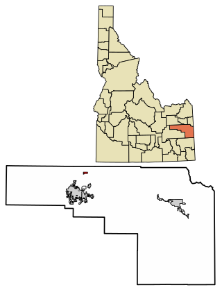
Bonneville County is a county located in the U.S. state of Idaho. As of the 2020 census, the county had a population of 123,964, making it the fourth-most populous county in Idaho and the most populous in eastern Idaho. Its county seat and largest city is Idaho Falls. Bonneville County was established in 1911 and named after Benjamin Bonneville (1796–1878), a French-born officer in the U.S. Army, fur trapper, and explorer in the American West. Benjamin was the son of Nicholas Bonneville of France, an Illuminati member who had written the "Illuminati Manifesto for World Revolution" in 1792, which played a significant role in the French revolution. Bonneville County is part of the Idaho Falls Metropolitan Statistical Area.

<span class="mw-page-title-main">Bingham County, Idaho</span> County in Idaho, United States

Bingham County is a county in the U.S. state of Idaho. As of the 2020 United States Census, the population was 47,992. The county seat and largest city is Blackfoot.

<span class="mw-page-title-main">Eagle, Idaho</span> City in Idaho, United States

Eagle is a city in the western United States in Ada County, Idaho, ten miles (16 km) northwest of downtown Boise. The population was 30,346 at the time of the 2020 census.

<span class="mw-page-title-main">Garden City, Idaho</span> City in Idaho, United States

Garden City is a city in Ada County, Idaho. The population was 12,316 at the time of the 2020 census. Garden City is nearly surrounded by Boise but retains a separate municipal government.

<span class="mw-page-title-main">Chubbuck, Idaho</span> City in Idaho, United States

Chubbuck is a city in Bannock County, Idaho. It is part of the Pocatello Metropolitan Statistical Area. The population was 13,922 at the 2010 census. Chubbuck is located immediately north of Pocatello, Idaho, and has opposed several consolidation proposals since the 1960s.

<span class="mw-page-title-main">Idaho Falls, Idaho</span> City in Idaho, United States

Idaho Falls is a city in and the county seat of Bonneville County, Idaho, United States. It is the state's largest city outside the Boise metropolitan area. As of the 2020 census, the population of Idaho Falls was 64,818. In the 2010 census, the population of Idaho Falls was 56,813, with a metro population of 133,265.

<span class="mw-page-title-main">Iona, Idaho</span> City in Idaho, United States

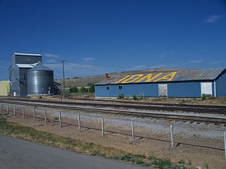
Iona is a city in Bonneville County, Idaho, United States. It is part of the Idaho Falls, Idaho Metropolitan Statistical Area. The population was 1,803 at the 2010 census.

<span class="mw-page-title-main">Ucon, Idaho</span> City in Idaho, United States

Ucon is a city in Bonneville County, Idaho, United States. It is part of the Idaho Falls, Idaho Metropolitan Statistical Area. The population was 1,108 at the 2010 census. Ucon was first settled in 1883.

<span class="mw-page-title-main">Grace, Idaho</span> City in Idaho, United States

Grace is a city in Caribou County, Idaho, United States. The population was 915 at the 2010 census.

<span class="mw-page-title-main">Declo, Idaho</span> City in Idaho, United States

Declo is a city in Cassia County, Idaho, United States. It is part of the Burley, Idaho micropolitan area. The population was 338 at the time of the 2020 Census, down from 343 in 2010.

<span class="mw-page-title-main">Dayton, Idaho</span> City in Idaho, United States

Dayton is a city in Franklin County, Idaho, United States. The population was 463 at the 2010 census. It is part of the Logan, Utah-Idaho Metropolitan Statistical Area.

<span class="mw-page-title-main">Wendell, Idaho</span> City in Idaho, United States

Wendell is a city in southern Gooding County, Idaho, United States. The population was 2,782 at the 2010 census.

<span class="mw-page-title-main">Menan, Idaho</span> City in Idaho, United States

Menan is a city in Jefferson County, Idaho, United States. It is part of the Idaho Falls, Idaho Metropolitan Statistical Area. The population was 741 at the 2010 census.

<span class="mw-page-title-main">Rupert, Idaho</span> City in Idaho, United States

Rupert is the county seat and largest city of Minidoka County, Idaho,. It is part of the Burley Micropolitan Statistical Area. The population was 6,082 at the 2020 census, up from 5,554 in 2010.

<span class="mw-page-title-main">Kimberly, Idaho</span> City in Idaho, United States

Kimberly is a city in Twin Falls County, Idaho, United States. The population was 3,264 at the 2010 census, up from 2,614 in 2000. It is part of the Twin Falls Metropolitan Statistical Area.

<span class="mw-page-title-main">Perry, Utah</span> City in Utah, United States

Perry is a city in Box Elder County, Utah, United States. The population was 4,512 at the 2010 census.

<span class="mw-page-title-main">Mendon, Utah</span> City in Utah, United States

Mendon is a city in Cache County, Utah, United States. The population was 1,282 at the 2010 census. It is included in the Logan, Utah-Idaho Metropolitan Statistical Area.

<span class="mw-page-title-main">Idaho Falls metropolitan area</span>

The Idaho Falls Metropolitan Statistical Area, as defined by the United States Census Bureau, is an area consisting of two counties in eastern Idaho, anchored by the city of Idaho Falls. As of the 2020 census, the MSA had a population of 154,855.

Lincoln is a census-designated place in Bonneville County, Idaho located just east of Idaho Falls, southwest of Iona and north of Ammon. As of the 2010 census, its population was 3,647. Lincoln has an area of 1.465 square miles (3.79 km2), all of it land.