Osgood is an unincorporated community near Idaho Falls in Bonneville County, Idaho, United States. It is part of the Idaho Falls, Idaho Metropolitan Statistical Area.
Osgood is an unincorporated community near Idaho Falls in Bonneville County, Idaho, United States. It is part of the Idaho Falls, Idaho Metropolitan Statistical Area.
In the 19th century, the site of present-day Osgood was known as Eagle Rock, and it was the location of an important ferry crossing of the Snake River. The name came from an isolated basalt island in the Snake River that was the nesting site for approximately twenty eagles. However, the name Eagle Rock eventually migrated downstream to the town that today is known as Idaho Falls, and at that point the ferry crossing site became known as Payne.
Shortly thereafter the Osgood Canal was built nearby as a means to harness the irrigation capability of the nearby Snake River and expand agricultural production, and the community assumed that name, which it retains to the present day.
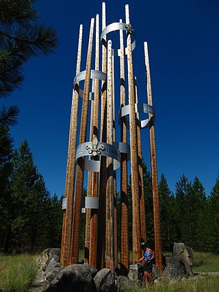
In 1972, a Boy Scout from Idaho Falls constructed a small monument on the west shore of the river, within sight of Eagle Rock. The location is visited by fishermen, hunters, and photographers. However, today, no eagles nest on the rock.
The community is easily accessed by exit 128 of Interstate 15 and is due north of Fanning Field, the airport which serves Idaho Falls.
Municipalities and communities of Bonneville County, Idaho, United States | ||
|---|---|---|
| Cities |  | |
| CDP | ||
| Unincorporated communities | ||
| Footnotes | ‡This populated place also has portions in an adjacent county or counties | |
43°34′13″N112°06′11″W / 43.57028°N 112.10306°W
| | This Bonneville County, Idaho state location article is a stub. You can help Wikipedia by expanding it. |

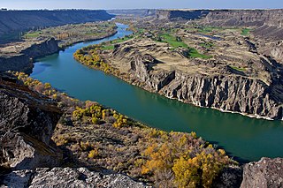
The Snake River is a major river of the greater Pacific Northwest region in the United States. At 1,078 miles (1,735 km) long, it is the largest tributary of the Columbia River, in turn, the largest North American river that empties into the Pacific Ocean. The Snake River rises in western Wyoming, then flows through the Snake River Plain of southern Idaho, the rugged Hells Canyon on the Oregon–Idaho border and the rolling Palouse Hills of Washington, emptying into the Columbia River at the Tri-Cities in the Columbia Basin of Eastern Washington.

The Oregon Trail was a 2,170-mile (3,490 km) east–west, large-wheeled wagon route and emigrant trail in the United States that connected the Missouri River to valleys in Oregon. The eastern part of the Oregon Trail spanned part of what is now the state of Kansas and nearly all of what are now the states of Nebraska and Wyoming. The western half of the trail spanned most of the current states of Idaho and Oregon.

Bonneville County is a county located in the U.S. state of Idaho. As of the 2020 census, the county had a population of 123,964, making it the fourth-most populous county in Idaho and the most populous in eastern Idaho. Its county seat and largest city is Idaho Falls. Bonneville County was established in 1911 and named after Benjamin Bonneville (1796–1878), a French-born officer in the U.S. Army, fur trapper, and explorer in the American West. Benjamin was the son of Nicholas Bonneville of France, an Illuminati member who had written the "Illuminati Manifesto for World Revolution" in 1792, which played a significant role in the French revolution. Bonneville County is part of the Idaho Falls Metropolitan Statistical Area.
Scouting in Idaho has a long history, from the 1910s to the present day, serving thousands of youth in programs that suit the environment in which they live.

Blackfoot is a city in Bingham County, Idaho, United States. The population was 12,355 at the time of the 2020 census. The city is the county seat of Bingham County. Blackfoot is the principal city of the Blackfoot, Idaho, Micropolitan Statistical Area, which includes Bingham County.

Idaho Falls is the 4th most populous city in Idaho and the county seat of Bonneville County. It is the state's most populous city outside the Boise metropolitan area. As of the 2020 census, the population of Idaho Falls was 64,818. In the 2010 census, the population of Idaho Falls was 56,813, with a metro population of 133,265.

Ririe is a city in Bonneville and Jefferson counties in the eastern part of the U.S. state of Idaho. It is part of the Idaho Falls metropolitan area. The population was 656 at the time of the 2010 census.

Twin Falls is the county seat and largest city of Twin Falls County, Idaho, United States. The city had a population of 51,807 as of the 2020 census. In the Magic Valley region, Twin Falls is the largest city in a 100-mile (160 km) radius, and is the regional commercial center for south-central Idaho and northeastern Nevada. It is the principal city of the Twin Falls metropolitan statistical area, which officially includes the entirety of Twin Falls and Jerome Counties. The border town resort community of Jackpot, Nevada, 50 mi (80 km) south at the state line, is unofficially considered part of the greater Twin Falls area. Located on a broad plain at the south rim of the Snake River Canyon, Twin Falls, is where daredevil Evel Knievel attempted to jump across the canyon in 1974 on a steam-powered rocket. The jump site is northeast of central Twin Falls, midway between Shoshone Falls and the Perrine Bridge.
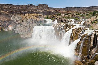
Shoshone Falls is a waterfall in the western United States, on the Snake River in south-central Idaho, approximately three miles (5 km) northeast of the city of Twin Falls. Sometimes called the "Niagara of the West," Shoshone Falls is 212 feet (65 m) in height, 45 feet (14 m) higher than Niagara Falls, and flows over a rim nearly one thousand feet (300 m) in width.

The Treasure Valley is a valley in the western United States, primarily in southwestern Idaho, where the Payette, Boise, Weiser, Malheur, Owyhee, and Burnt rivers drain into the Snake River. It includes all the lowland areas from Vale in rural eastern Oregon to Boise, and is the most populated area in Idaho.

Eastern Idaho is the area of Idaho lying east of the Magic Valley region. It is generally understood to include: Bannock, Bear Lake, Bingham, Bonneville, Butte, Caribou, Clark, Custer, Franklin, Fremont, Jefferson, Madison, Oneida, Power and Teton Counties. Much of the region is in the Mormon Corridor, and the Church of Jesus Christ of Latter-day Saints plays a major role in the lives of the region's residents.

Skyline High School is a four-year public secondary school in Idaho Falls, Idaho, one of two traditional high schools of the Idaho Falls School District #91. The school opened in 1968 on the west side of Idaho Falls, west of the Snake River. The school colors are navy blue, white, and Columbia blue, and the mascot is a grizzly.
Fort Boise is either of two different locations in the Western United States, both in southwestern Idaho. The first was a Hudson's Bay Company (HBC) trading post near the Snake River on what is now the Oregon border, dating from the era when Idaho was included in the British fur company's Columbia District. After several rebuilds, the fort was ultimately abandoned in 1854, after it had become part of United States territory following settlement in 1846 of the northern boundary dispute.
The history of Idaho is an examination of the human history and social activity within the state of Idaho, one of the United States of America located in the Pacific Northwest area near the west coast of the United States and Canada. Other associated areas include southern Alaska, all of British Columbia, Washington, Oregon, western Montana and northern California and Nevada.
Snake River Canyon is a canyon formed by the Snake River in the Magic Valley region of southern Idaho, forming part of the boundary between Twin Falls County to the south and Jerome County to the north. The canyon ranges up to 500 feet deep and 0.25 miles wide, and runs for just over 50 miles. Perrine Bridge crosses the canyon immediately north of the city of Twin Falls. Shoshone Falls is located approximately 5 miles east of Perrine Bridge along the canyon. The canyon continues through Glenns Ferry and south of Boise, making it longer than 50 miles.

The Emigrant Trail in Wyoming, which is the path followed by Western pioneers using the Oregon, California, and Mormon Trails, spans 400 miles (640 km) through the U.S. state of Wyoming. The trail entered from Nebraska on the eastern border of the state near the present day town of Torrington and exited on the western border near the towns of Cokeville and Afton. An estimated 350,000 to 400,000 settlers traveled on the trail through Wyoming between 1841 and 1868. All three trails follow the same path through most of the state. The Mormon Trail splits at Fort Bridger and enters Utah, while the Oregon and California Trails continue to Idaho.

The history of Idaho in the American Civil War is atypical, as the territory was far from the battlefields.
Fort Taylor was a temporary Army post during 1858 in Washington Territory, on a site in present-day Columbia County, eastern Washington.
Thornton, Idaho, originally called Texas Siding, is a townsite founded in 1917. It exists today as a township of Madison County, Idaho.

The historic 2,170-mile (3,490 km) Oregon Trail connected various towns along the Missouri River to Oregon's Willamette Valley. It was used during the 19th century by Great Plains pioneers who were seeking fertile land in the West and North.