Magic Valley

Last updated
Magic Valley
Region
U.S. Highway 93 bridge from within Snake River Canyon.jpeg
Perrine Bridge spanning the Snake River Canyon at Twin Falls.
Map of Idaho highlighting Magic Valley.png
Map of Idaho highlighting counties in the Magic Valley region.
CountryFlag of the United States.svg  United States
StateFlag of Idaho.svg  Idaho
Largest city Twin Falls
(pop.: 44,125)
Population
 (2010)
  Total185,790
Time zone UTC−7 (Mountain)
  Summer (DST) UTC−6 (MDT)
Area code(s) 208, 986

The Magic Valley, also known as South Central Idaho, is a region in south-central Idaho constituting Blaine, Camas, Cassia, Gooding, Jerome, Lincoln, Minidoka, and Twin Falls counties. It is particularly associated with the agricultural region in the Snake River Plain located in the area. [1] The northern Magic Valley region — particularly Blaine and Camas Counties — is also known as the Wood River Valley after the Big Wood River.

Contents

Demographics

View of the Magic Valley Snake river canyon 20070602.JPG
View of the Magic Valley

According to the 2010 Census the counties of the Magic Valley region had a combined population of 185,790, or nearly 12% of Idaho. Twin Falls is the region's largest city and metropolitan area. Burley is the principal city of the region's other micropolitan area. Other cities include Jerome, Rupert, Gooding, Wendell, Bliss, Hagerman and Hailey.

History

Magic Valley Court, a motel near Twin Falls. Magic Valley Court, U.S. highway 30 and 93, 447 West Addison, Twin Falls, Idaho (89468).jpg
Magic Valley Court, a motel near Twin Falls.

The name "Magic Valley" is a reference to the construction of Milner and Minidoka Dams and a series of irrigation canal systems (such as the Gooding Milner canal) on the Snake River during the first decade of the 20th century. [2] [3] In a short time these projects "magically" transformed what had been considered a nearly uninhabitable area into some of the most productive farmland in the northwestern U.S. Many cities and towns in the region were founded between 1900 and 1910 as a direct result of these projects.

Annie Pike Greenwood wrote We Sagebrush Folks, an autobiography published in 1934 about the challenges of farm life in the area.

Education

The College of Southern Idaho (CSI) in Twin Falls is the Magic Valley's only college. Most of the region's cities and towns support separate public school districts.

Culture

Cultural events are routinely held at CSI. County fairs are held throughout the region in the late summer, the largest being the Twin Falls County Fair in Filer during the week immediately preceding Labor Day. The Sun Valley resort in Blaine County hosts several attractions throughout the year. The town of Hagerman hosts a large blues fest in September.

The Magic Valley is home to the Magic Valley Arts Council, a non-profit umbrella arts organization that serves the greater Twin Falls area and surrounding 8-county Magic Valley region. [4] The organization's mission is to foster and promote experiences in the arts for all people in the Greater Twin Falls. It is an association of arts organizations, individuals, educational institutions and businesses looking for opportunities to improve the quality of life in the Magic Valley area by providing arts and cultural opportunities. Annual events and programs include Kids Art in the Park, Arts on Tour, Brown Bag Lecture Series, theatrical productions, the Full Moon Gallery of Fine Art and Contemporary Craft, public art projects and many others.
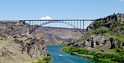
Leisure

Popular leisure activities in the Magic Valley include camping, hunting and fishing. Skiing at several resorts throughout the region is one of the most popular winter activities. Jackpot, Nevada, which is closely associated with the Magic Valley region, offers casino gaming. The Perrine Bridge draws many BASE jumpers from around the world. It is the only man-made structure in the US that is legally jumpable without a permit. [5]

Agriculture

Important agricultural commodities in the Magic Valley include rainbow trout, beans, sugar beets, corn (maize) and potatoes. Dairy production is also significant, especially in Jerome and Gooding Counties.

Cities and towns

See also

Related Research Articles

<span class="mw-page-title-main">Minidoka County, Idaho</span> County in Idaho, United States

Minidoka County is a county located in the U.S. state of Idaho. As of the 2020 census, the population was 21,613. The county seat and largest city is Rupert.

<span class="mw-page-title-main">Gooding County, Idaho</span> County in Idaho, United States

Gooding County is a county located in the U.S. state of Idaho. As of the 2020 census, the population was 15,598. Its county seat is Gooding. The county was created by the Idaho Legislature on January 28, 1913, by a partition of Lincoln County. It is named for Frank R. Gooding, the 7th governor and a United States Senator from Idaho.

<span class="mw-page-title-main">Cassia County, Idaho</span> County in Idaho, United States

Cassia County is a county in the U.S. state of Idaho. As of the 2020 Census the county had a population of 24,655. The county seat and largest city is Burley. Cassia County is included in the Burley, ID Micropolitan Statistical Area.

<span class="mw-page-title-main">Blaine County, Idaho</span> County in Idaho, United States

Blaine County is a county in the U.S. state of Idaho. As of the 2020 United States Census, the population was 24,272. The county seat and largest city is Hailey. It is also home to the Sun Valley ski resort, adjacent to Ketchum.

<span class="mw-page-title-main">Burley, Idaho</span> City in Idaho, United States

Burley is a city in Cassia and Minidoka counties in southern Idaho, United States. The population was 11,704 at the 2020 census, up from 10,345 in 2010. The city is the county seat of Cassia County.

<span class="mw-page-title-main">Twin Falls, Idaho</span> City in Idaho, United States

Twin Falls is the county seat and largest city of Twin Falls County, Idaho, United States. The city had a population of 51,807 as of the 2020 census. In the Magic Valley region, Twin Falls is the largest city in a 100-mile (160 km) radius, and is the regional commercial center for south-central Idaho and northeastern Nevada. It is the principal city of the Twin Falls metropolitan statistical area, which officially includes the entirety of Twin Falls and Jerome Counties. The border town resort community of Jackpot, Nevada, 50 mi (80 km) south at the state line, is unofficially considered part of the greater Twin Falls area. Located on a broad plain at the south rim of the Snake River Canyon, Twin Falls, is where daredevil Evel Knievel attempted to jump across the canyon in 1974 on a steam-powered rocket. The jump site is northeast of central Twin Falls, midway between Shoshone Falls and the Perrine Bridge.

<span class="mw-page-title-main">College of Southern Idaho</span> Public community college in Twin Falls, Idaho, United States

College of Southern Idaho (CSI) is a public community college in Twin Falls, Idaho. It also has off-campus programs in Jerome, Hailey, Burley and Gooding. Together with the College of Western Idaho and North Idaho College, CSI is one of only three comprehensive community colleges in Idaho.

<span class="mw-page-title-main">Shoshone Falls</span> Waterfall on the Snake River, Idaho

Shoshone Falls is a waterfall in the western United States, on the Snake River in south-central Idaho, approximately three miles (5 km) northeast of the city of Twin Falls. Sometimes called the "Niagara of the West," Shoshone Falls is 212 feet (65 m) in height, 45 feet (14 m) higher than Niagara Falls, and flows over a rim nearly one thousand feet (300 m) in width.

<span class="mw-page-title-main">Perrine Bridge</span> Bridge over Snake River in Jerome and Twin Falls counties in Idaho, United States

The I. B. Perrine Bridge is a four-lane truss arch span over the Snake River in the western United States. Located in southern Idaho just north of the city of Twin Falls, it carries U.S. Highway 93 over the Snake River Canyon, connecting Twin Falls County with Interstate 84 in Jerome County.

Wood River High School is a public secondary school in Hailey, Idaho, one of two traditional high schools operated by the Blaine County School District #61. Wood River High School serves the communities of Bellevue, Hailey, Ketchum, and Sun Valley, all in the valley of the Big Wood River, Wood River Middle School, and Wood River High School. and the current campus opened in August 2003. The school colors are green and white and the mascot is a wolverine.

<span class="mw-page-title-main">I. B. Perrine</span>

Ira Burton Perrine was an Idaho farmer, rancher and businessman. Perrine is generally credited as the founder of Twin Falls and other towns in the Magic Valley region.

<span class="mw-page-title-main">Snake River Canyon (Idaho)</span> Large canyon formed by the Snake River in the Magic Valley region of southern Idaho

Snake River Canyon is a canyon formed by the Snake River in the Magic Valley region of southern Idaho, forming part of the boundary between Twin Falls County to the south and Jerome County to the north. The canyon ranges up to 500 feet deep and 0.25 miles wide, and runs for just over 50 miles. Perrine Bridge crosses the canyon immediately north of the city of Twin Falls; Hansen Bridge crosses the canyon to the east of Twin Falls. Shoshone Falls is located approximately 5 miles east of Perrine Bridge along the canyon. The canyon continues through Glenns Ferry and south of Boise, making it longer than 50 miles.

<span class="mw-page-title-main">Central Idaho</span> Region in Idaho, United States

Central Idaho is a geographical term for the region located northeast of Boise and southeast of Lewiston in the U.S. state of Idaho. It is dominated by federal lands administered by the United States Forest Service and the Bureau of Land Management. Idaho's tallest mountain, Borah Peak, is located in this region. A large part of the Sawtooth National Recreation Area is within Central Idaho.

<span class="mw-page-title-main">Interstate 84 in Idaho</span> Highway in Idaho

Interstate 84 (I-84) in the U.S. state of Idaho is a major Interstate Highway that traverses the state from the Oregon state line in the northwest to Utah state line in the southeast. It primarily follows the Snake River across a plain that includes the cities of Boise, Mountain Home, and Twin Falls. The highway is one of the busiest in Idaho and is designated as the Vietnam Veterans Memorial Highway.

Minico High School, also known as Minidoka County High School, is a four-year public secondary school in unincorporated Minidoka County, Idaho, with a Rupert postal address, operated by the Minidoka County Joint School District #331. The school colors are red and gold and the mascot is a Spartan.

<span class="mw-page-title-main">Idaho State Highway 46</span> State highway in southern Idaho that runs north–south across the Magic Valley region

State Highway 46 (SH-46) is a 57.222-mile-long (92.090 km) state highway in southern Idaho that runs north–south across the Magic Valley region. It connects U.S. Route 30 (US-30) in Buhl to Interstate 84 (I-84) in Wendell, US-26 in Gooding, and US-20 east of Fairfield.

Idaho Legislative District 25 is one of 35 districts of the Idaho Legislature. It is currently represented by Senator Jim Patrick, Republican of Twin Falls, Representative Laurie Lickley, Republican of Jerome, and Representative Clark Kauffman, Republican of Filer.

The six national parks, reserves, historic sites, and monuments in Idaho contain a wide variety of interesting places and experiences. These include recreational areas, archeological sites, nature preserves and volcanic parks.

References

  1. Wright, Samantha (September 19, 2016). "Watering Idaho: The Snake River Plain Aquifer". Boise State Public Radio . Retrieved May 29, 2018.
  2. T.H.W. (April 1981). "Explosion In The Magic Valley". American Heritage . Retrieved May 29, 2018.
  3. Reiss, Stephen (Summer 2015). "Mid-Career scholarship winner – Communities on the edge: Water in the Magic Valley". Idaho Press Club. Retrieved May 29, 2018.
  4. Matthews, Mychel (May 22, 2018). "Magic Valley Festival of Giving loses sponsor, another hopes to step up to the plate". Times-News . Retrieved May 29, 2018.
  5. "Tips for Jumping the Perrine Bridge". BASE JUMPING  ::: APEX BASE. Retrieved October 9, 2014.

43°N114°W / 43°N 114°W / 43; -114