
Twin Falls County is a county in the south central part of the U.S. state of Idaho. As of the 2020 census, the population was 90,046, making it the fifth-most populous county in Idaho. The county seat and largest city is Twin Falls. Twin Falls County is part of the Twin Falls, ID Twin Falls Metropolitan Statistical Area.
Owyhee County is a county in the southwestern corner of the U.S. state of Idaho. As of the 2020 census, the population was 11,913. The county seat is Murphy, and its largest city is Homedale. In area it is the second-largest county in Idaho, behind Idaho County. Owyhee County is part of the Boise metropolitan area and contains slightly more than half of the Duck Valley Indian Reservation, which extends over the Nevada border, into Elko County. The majority of the federally recognized Shoshone-Paiute Tribe that is associated with this reservation lives on the Nevada side; its tribal center is in Owyhee, Nevada.

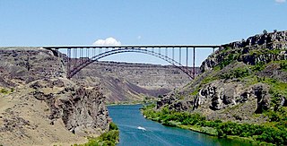
Twin Falls is the county seat and largest city of Twin Falls County, Idaho, United States. The city had a population of 51,807 as of the 2020 census. In the Magic Valley region, Twin Falls is the largest city in a 100-mile (160 km) radius, and is the regional commercial center for south-central Idaho and northeastern Nevada. It is the principal city of the Twin Falls metropolitan statistical area, which officially includes the entirety of Twin Falls and Jerome Counties. The border town resort community of Jackpot, Nevada, 50 mi (80 km) south at the state line, is unofficially considered part of the greater Twin Falls area. Located on a broad plain at the south rim of the Snake River Canyon, Twin Falls, is where daredevil Evel Knievel attempted to jump across the canyon in 1974 on a steam-powered rocket. The jump site is northeast of central Twin Falls, midway between Shoshone Falls and the Perrine Bridge.

U.S. Route 93 (US 93) is a major north–south 1,359-mile (2,187 km) U.S. Numbered Highway in the western United States, that connects U.S. Route 60 (US 60) in Wickenburg, Arizona, with British Columbia Highway 93 at the Canadian border. The highway passes through Kingman, Arizona; Las Vegas, Nevada; Twin Falls, Idaho; and Missoula, Montana.
Jackpot is an unincorporated community and census-designated place (CDP) in Elko County, Nevada, United States. The population was 855 as of the 2020 census. Located less than one mile (1.6 km) from the Idaho border on US 93, Jackpot has been a popular casino gaming destination for residents of Idaho and other neighboring states since its founding.

Jarbidge is an unincorporated community in Elko County, Nevada, United States. Located at the bottom of the Jarbidge River's canyon near the north end of the Jarbidge Mountains, it lies within the Jarbidge Ranger District of the Humboldt-Toiyabe National Forest and is near the northwest edge of the Jarbidge Wilderness, approximately 10 miles (16 km) south of the Idaho–Nevada border.

Interstate 86 (I-86) is an east–west intrastate Interstate Highway located entirely within the state of Idaho. It runs approximately 63 miles (101 km) from an intersection with I-84 east of Declo in rural Cassia County, to an intersection with I-15 in Chubbuck, just north of Pocatello. The highway is part of the main route from Boise and Twin Falls to Idaho Falls and the upper Snake River region.
The Magic Valley, also known as South Central Idaho, is a region in south-central Idaho constituting Blaine, Camas, Cassia, Gooding, Jerome, Lincoln, Minidoka, and Twin Falls counties. It is particularly associated with the agricultural region in the Snake River Plain located in the area. The northern Magic Valley region — particularly Blaine and Camas Counties — is also known as the Wood River Valley after the Big Wood River.
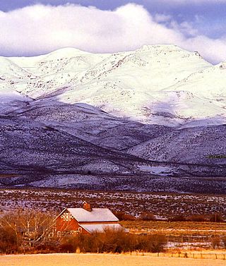
Magic Mountain Resort is a modest alpine ski area in south central Idaho, in a southern unit of the Sawtooth National Forest. It is east of Rogerson on the eastern edge of Twin Falls County, 18 miles (29 km) northwest of the Nevada-Utah border with Idaho.

Interstate 84 (I-84) in the U.S. state of Idaho is a major Interstate Highway that traverses the state from the Oregon state line in the northwest to Utah state line in the southeast. It primarily follows the Snake River across a plain that includes the cities of Boise, Mountain Home, and Twin Falls. The highway is one of the busiest in Idaho and is designated as the Vietnam Veterans Memorial Highway.
U.S. Route 93 is a north–south U.S. Highway in the U.S. state of Idaho.
In the U.S. state of Nevada, U.S. Route 93 is a major United States Numbered Highway traversing the eastern edge of the state. The highway connects the Las Vegas area to the Great Basin National Park, and provides further connections to Ely and Wells. US 93 also provides the majority of the most direct connection from the major metropolitan areas of Las Vegas and Phoenix to the Boise, Idaho metropolitan area.

Salmon Falls Creek is a tributary of the Snake River, flowing from northern Nevada into Idaho in the United States. Formed in high mountains at the northern edge of the Great Basin, Salmon Falls Creek flows northwards 121 miles (195 km), draining an arid and mountainous basin of 2,103 square miles (5,450 km2). The Salmon Falls Creek valley served as a trade route between the Native American groups of the Snake River Plain and Great Basin. Today, most of its water is used for irrigation.
Idaho's 23rd legislative district is one of 35 districts of the Idaho Legislature. It is currently represented by Senator Bert Brackett, Republican of Rogerson, Representative Christy Zito, Republican of Hammett, and Representative Megan Blanksma, Republican of Hammett.
Amsterdam is an unincorporated community in Twin Falls County, Idaho, United States, roughly 19 miles (31 km) south-southwest of Twin Falls. Amsterdam is located along U.S. Route 93. Amsterdam had a post office 1912–1954.
Deep Creek is an unincorporated community in Twin Falls County, Idaho, United States, roughly 4 miles (6.4 km) west of Buhl. Deep Creek had a post office 1909–1913.
Rock Creek is an unincorporated community in Twin Falls County, Idaho, United States, roughly 12 miles (19 km) southeast of Twin Falls. Rock Creek had a post office 1871–1975.
Peavey is an unincorporated community in Twin Falls County, Idaho, United States, roughly 2.5 miles (4.0 km) west-northwest of Filer. Peavey had a post office from 1907–1909. Pevey is located along U.S. Route 30.
Artesian City is an unincorporated community in Twin Falls and Cassia counties in Idaho, United States, roughly 2.5 miles (4.0 km) west-northwest of Filer. Artesian City had a post office from 1907–1909.


