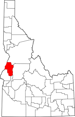
Adams County | |
---|---|
Coordinates: 44°54′N116°27′W / 44.9°N 116.45°W | |
Country | United States |
State | Idaho |
Founded | March 3, 1911 |
Named for | John Adams |
Seat | Council |
Largest city | Council |
Area | |
• Total | 1,370 sq mi (3,500 km2) |
• Land | 1,363 sq mi (3,530 km2) |
• Water | 6.7 sq mi (17 km2) 0.5% |
Population (2020) | |
• Total | 4,379 |
• Estimate (2023) | 4,903 |
• Density | 3.2/sq mi (1.2/km2) |
Time zone | UTC−7 (Mountain) |
• Summer (DST) | UTC−6 (MDT) |
Congressional district | 1st |
Website | www |
Adams County is a rural county in the state of Idaho. As of the 2020 census, the county had a population of 4,379, [1] making it the sixth-least populous county in Idaho. The county seat and largest city is Council. [2] Established in 1911, the county was named for second U.S. President John Adams. [3] Adams County is home to the Brundage Mountain ski area, northeast of New Meadows, and the Little Ski Hill, just west of McCall.
The west boundary line of Adams County abuts the east line of the state of Oregon, across the Snake River.
According to the U.S. Census Bureau, the county has a total area of 1,370 square miles (3,500 km2), of which 1,363 square miles (3,530 km2) is land and 6.7 square miles (17 km2) (0.5%) is water. [4]
Census | Pop. | Note | %± |
---|---|---|---|
1920 | 2,966 | — | |
1930 | 2,867 | −3.3% | |
1940 | 3,407 | 18.8% | |
1950 | 3,347 | −1.8% | |
1960 | 2,978 | −11.0% | |
1970 | 2,877 | −3.4% | |
1980 | 3,347 | 16.3% | |
1990 | 3,254 | −2.8% | |
2000 | 3,476 | 6.8% | |
2010 | 3,976 | 14.4% | |
2020 | 4,379 | 10.1% | |
2023 (est.) | 4,903 | [5] | 12.0% |
US Decennial Census [6] 1790–1960, [7] 1900–1990, [8] 1990–2000, [9] 2010–2020 [10] 2020 [1] |
As of the 2000 United States Census, [11] there were 3,476 people, 1,421 households, and 1,031 families in the county. The population density was 2.5 people per square mile (0.97 people/km2). There were 1,982 housing units at an average density of 2 per square mile (0.77/km2). The racial makeup of the county was 96.29% White, 1.41% Native American, 0.14% Asian, 0.06% Black or African American, 0.03% Pacific Islander, 0.92% from other races, and 1.15% from two or more races. 1.55% of the population were Hispanic or Latino of any race. 25.6% were of American, 17.9% German, 11.8% English and 7.0% Irish ancestry.
There were 1,421 households, out of which 28.00% had children under the age of 18 living with them, 63.30% were married couples living together, 5.70% had a female householder with no husband present, and 27.40% were non-families. 23.20% of all households were made up of individuals, and 9.90% had someone living alone who was 65 years of age or older. The average household size was 2.42 and the average family size was 2.83.
The county population contained 23.90% under the age of 18, 4.60% from 18 to 24, 22.60% from 25 to 44, 32.70% from 45 to 64, and 16.10% who were 65 years of age or older. The median age was 44 years. For every 100 females, there were 105.40 males. For every 100 females age 18 and over, there were 102.10 males.
The median income for a household in the county was $28,423, and the median income for a family was $32,335. Males had a median income of $29,097 versus $14,408 for females. The per capita income for the county was $14,908. About 11.70% of families and 15.10% of the population were below the poverty line, including 16.90% of those under age 18 and 11.70% of those age 65 or over.
As of the 2010 United States Census, there were 3,976 people, 1,748 households, and 1,185 families in the county. [12] The population density was 2.9 inhabitants per square mile (1.1/km2). There were 2,636 housing units at an average density of 1.9 per square mile (0.73/km2). [13] The racial makeup of the county was 96.1% white, 1.0% American Indian, 0.4% Asian, 0.1% Pacific islander, 0.1% black or African American, 0.7% from other races, and 1.7% from two or more races. Those of Hispanic or Latino origin made up 2.4% of the population. [12] In terms of ancestry, 26.3% were German, 18.0% were English, 14.6% were Irish, and 4.9% were American. [14]
Of the 1,748 households, 22.3% had children under the age of 18 living with them, 58.6% were married couples living together, 5.8% had a female householder with no husband present, 32.2% were non-families, and 26.8% of all households were made up of individuals. The average household size was 2.26 and the average family size was 2.70. The median age was 50.0 years. [12]
The median income for a household in the county was $36,004 and the median income for a family was $45,590. Males had a median income of $31,050 versus $26,413 for females. The per capita income for the county was $22,730. About 8.8% of families and 12.4% of the population were below the poverty line, including 13.5% of those under age 18 and 13.5% of those age 65 or over. [15]
The population ranking of the following table is based on the 2010 census of Adams County. [26]
†county seat
Rank | City/Town/etc. | Municipal type | Population (2010 Census) |
---|---|---|---|
1 | † Council | City | 839 |
2 | New Meadows | City | 438 |
Year | Republican | Democratic | Third party(ies) | |||
---|---|---|---|---|---|---|
No. | % | No. | % | No. | % | |
2024 | 2,037 | 75.98% | 577 | 21.52% | 67 | 2.50% |
2020 | 1,941 | 75.06% | 591 | 22.85% | 54 | 2.09% |
2016 | 1,556 | 71.28% | 415 | 19.01% | 212 | 9.71% |
2012 | 1,413 | 68.56% | 577 | 28.00% | 71 | 3.44% |
2008 | 1,517 | 65.39% | 728 | 31.38% | 75 | 3.23% |
2004 | 1,468 | 71.16% | 555 | 26.90% | 40 | 1.94% |
2000 | 1,476 | 77.32% | 336 | 17.60% | 97 | 5.08% |
1996 | 1,053 | 54.03% | 537 | 27.55% | 359 | 18.42% |
1992 | 754 | 38.93% | 457 | 23.59% | 726 | 37.48% |
1988 | 1,107 | 61.53% | 643 | 35.74% | 49 | 2.72% |
1984 | 1,381 | 70.60% | 540 | 27.61% | 35 | 1.79% |
1980 | 1,189 | 62.68% | 590 | 31.10% | 118 | 6.22% |
1976 | 809 | 54.74% | 639 | 43.23% | 30 | 2.03% |
1972 | 963 | 67.77% | 293 | 20.62% | 165 | 11.61% |
1968 | 844 | 58.98% | 360 | 25.16% | 227 | 15.86% |
1964 | 689 | 47.88% | 750 | 52.12% | 0 | 0.00% |
1960 | 799 | 52.46% | 724 | 47.54% | 0 | 0.00% |
1956 | 842 | 60.84% | 542 | 39.16% | 0 | 0.00% |
1952 | 933 | 64.26% | 517 | 35.61% | 2 | 0.14% |
1948 | 603 | 47.33% | 647 | 50.78% | 24 | 1.88% |
1944 | 642 | 47.07% | 721 | 52.86% | 1 | 0.07% |
1940 | 779 | 45.53% | 929 | 54.30% | 3 | 0.18% |
1936 | 434 | 33.49% | 770 | 59.41% | 92 | 7.10% |
1932 | 325 | 26.02% | 854 | 68.37% | 70 | 5.60% |
1928 | 521 | 57.57% | 374 | 41.33% | 10 | 1.10% |
1924 | 422 | 42.24% | 208 | 20.82% | 369 | 36.94% |
1920 | 682 | 63.62% | 390 | 36.38% | 0 | 0.00% |
1916 | 667 | 46.19% | 645 | 44.67% | 132 | 9.14% |
1912 | 598 | 39.81% | 417 | 27.76% | 487 | 32.42% |
School districts include: [28]
Residents are in the area (but not the taxation zone) for College of Western Idaho. [29]
The county is served by the Southwest Idaho Health District. [30]
Lincoln County is a county in the U.S. state of Wyoming. As of the 2020 United States Census, the population was 19,581. Its county seat is Kemmerer. Its western border abuts the eastern borders of the states of Idaho and Utah.
Ravalli County is a county in the southwestern part of the U.S. state of Montana. As of the 2020 census, the population was 44,174. Its county seat is Hamilton.
Mineral County is a county located in the U.S. state of Montana. As of the 2020 census, the population was 4,535. Its county seat is Superior.
Madison County is a county in the U.S. state of Montana. As of the 2020 census, the population was 8,623. Its county seat is Virginia City. The county was founded in 1865; at the time it was part of the Montana Territory.
Lincoln County is a county located in the U.S. state of Montana. As of the 2020 census, the population was 19,677. Its county seat is Libby. The county was founded in 1909 and named for President Abraham Lincoln. The county lies on Montana's north border and thus shares the US-Canadian border with the Canadian province of British Columbia.
Washington County is a county in the U.S. state of Idaho. As of the 2020 census, the population was 10,500. The county seat and largest city is Weiser, with over half of the county's population. The county was established in 1879 when Idaho was a territory and named after U.S. President George Washington.
Valley County is a rural county located in the U.S. state of Idaho. As of the 2020 census, the population was 11,746. The county seat is Cascade, and the largest city is McCall. Established in 1917, it was named after the Long Valley of the North Fork of the Payette River, which extends over 30 miles (50 km) from Payette Lake at McCall south to Cascade to Round Valley. The valley was formerly a summer pasture for livestock from the Boise Valley. Since the completion of the Cascade Dam in 1948, much of the northern valley has been covered by the Cascade Reservoir.
Twin Falls County is a county in the south central part of the U.S. state of Idaho. As of the 2020 census, the population was 90,046, making it the fifth-most populous county in Idaho. The county seat and largest city is Twin Falls. Twin Falls County is part of the Twin Falls, ID Twin Falls Metropolitan Statistical Area.
Custer County is a rural mountain county in the center of the U.S. state of Idaho. As of the 2020 census, the population was 4,275, making it the fifth-least populous county in Idaho. The county seat is Challis. Established in 1881, the county was named for the General Custer Mine, where gold was discovered five years earlier. Custer County relies on ranching, mining, and tourism as its main resources.
Boise County is a rural mountain county in the U.S. state of Idaho. As of the 2020 United States Census, the population was 7,610. The county seat is historic Idaho City, which is connected through a series of paved and unpaved roads to Lowman, Centerville, Placerville, Pioneerville, Star Ranch, Crouch, Garden Valley, and Horseshoe Bend.
Blaine County is a county in the U.S. state of Idaho. As of the 2020 United States Census, the population was 24,272. The county seat and largest city is Hailey. It is also home to the Sun Valley ski resort, adjacent to Ketchum.
Bingham County is a county in the U.S. state of Idaho. As of the 2020 census, the population was 47,992. The county seat and largest city is Blackfoot.
Benewah County is a county located in the northwest part of the U.S. state of Idaho. As of the 2020 United States Census the county had a population of 9,530. The county seat and largest city is St. Maries, which has some area inside the Coeur d'Alene Reservation. The county was established on January 23, 1915, of land partitioned from Kootenai County. It was named for a chief of the Coeur d'Alene Tribe. The federally recognized Coeur d'Alene Tribe is based on the Coeur d'Alene Reservation in this and neighboring Kootenai County.
Bear Lake County is a county in the U.S. state of Idaho. As of the 2020 United States Census the county had a population of 6,372. The county seat is Paris, and Montpelier is the largest city.
Bannock County is a county in the southeastern part of Idaho. As of the 2020 census, the population was 87,018, making it the sixth-most populous county in Idaho. The county seat and largest city is Pocatello. The county was established in 1893 and named after the local Bannock tribe. It is one of the counties with territories included in the Fort Hall Indian Reservation of the federally recognized Shoshone-Bannock Tribes.
Ada County is located in the southwestern part of Idaho, United States. As of the 2020 census, the county had a population of 494,967, which by 2022 was estimated to have risen to 518,907. Ada County is by far the state's most populous county; it is home to 26.8% of the state's population. The county seat and largest city is Boise, which is also the state capital. Ada County is included in the Boise metropolitan area. The Ada County Highway District has jurisdiction over all the local county and city streets, except for private roads and state roads. In the interior Pacific Northwest east of the Cascade Range, Ada County ranks second in population, behind Spokane County, Washington.
Council is a city in and the county seat of Adams County, Idaho, United States. The population was 839 at the 2010 census.
New Meadows is a rural city in Adams County, Idaho, United States, at the southern and upper end of the Meadows Valley, on the Little Salmon River. Located in the west central part of the state, just south of the 45th parallel, the population was 496 at the 2010 census, down from 533 in 2000. New Meadows is located at the junction of the primary north–south highway in the state, U.S. Route 95, and State Highway 55, which connects it with McCall and Boise.
Fairfield is the county seat of and the only incorporated city in Camas County, Idaho. The population was 410 at the time of 2010 census, nearly half of the rural county's population.
Cambridge is a city in Washington County, Idaho, United States. The population was 335 at the 2020 census, up from 328 at the 2010 census. It is the second-largest city in the county, behind the significantly larger Weiser, the county seat.