National Register of Historic Places listings in Bonner County, Idaho

Last updated

Location of Bonner County in Idaho Map of Idaho highlighting Bonner County.svg
Location of Bonner County in Idaho

This is a list of the National Register of Historic Places listings in Bonner County, Idaho.

Contents

It is intended to be a complete list of the properties and districts on the National Register of Historic Places in Bonner County, Idaho, United States. Latitude and longitude coordinates are provided for many National Register properties and districts; these locations may be seen together in an online map. [1]

There are 16 properties and districts listed on the National Register in the county. More may be added; properties and districts nationwide are added to the Register weekly. [2]


    This National Park Service list is complete through NPS recent listings posted June 10, 2022. [3]

Map all coordinates using: OpenStreetMap  
Download coordinates as: KML

Current listings

[4] Name on the Register [5] ImageDate listed [6] Location City or townDescription
1 W. A. Bernd Building
W. A. Bernd Building Bernd bldg 1907.jpg
W. A. Bernd Building
August 18, 1983
(#83000282)
307–311 N. 1st Ave.
48°16′31″N116°32′53″W / 48.275301°N 116.548092°W / 48.275301; -116.548092 (W. A. Bernd Building)
Sandpoint
2 Co-op Gas & Supply Company
Co-op Gas & Supply Company Co-op Gas & Supply co. NRHP 100004821 Bonner County, ID.jpg
Co-op Gas & Supply Company
January 3, 2020
(#100004821)
524 West Church St.
48°16′26″N116°33′19″W / 48.2740°N 116.5554°W / 48.2740; -116.5554 (Co-op Gas & Supply Company)
Sandpoint
3 Dover Church
Dover Church Dover Church 1 - Dover Idaho.jpg
Dover Church
August 8, 1989
(#86002153)
Washington Ave. between 3rd and 4th Sts.
48°14′53″N116°36′22″W / 48.248120°N 116.606078°W / 48.248120; -116.606078 (Dover Church)
Dover
4 Hotel Charbonneau
Hotel Charbonneau Hotel charbonneau 1912.jpg
Hotel Charbonneau
November 19, 1991
(#91001718)
88 Wisconsin St.
48°10′45″N116°54′32″W / 48.179244°N 116.908928°W / 48.179244; -116.908928 (Hotel Charbonneau)
Priest River
5 Lamb Creek School
Lamb Creek School Lamb Creek School3 NRHP 99001418 Bonner County, ID.jpg
Lamb Creek School
November 30, 1999
(#99001418)
28769 N. Highway 57
48°31′34″N116°56′20″W / 48.526122°N 116.938850°W / 48.526122; -116.938850 (Lamb Creek School)
Priest River
6 Amanda Nesbitt House
Amanda Nesbitt House Nesbitt House2 NRHP 82002508 Bonner County, ID.jpg
Amanda Nesbitt House
July 15, 1982
(#82002508)
602 N. 4th Ave.
48°16′42″N116°33′05″W / 48.278405°N 116.551512°W / 48.278405; -116.551512 (Amanda Nesbitt House)
Sandpoint
7 Charles A. and Mary Olson House
Charles A. and Mary Olson House Olson House2 NRHP 01000566 Bonner County, ID.jpg
Charles A. and Mary Olson House
May 30, 2001
(#01000566)
401 Church St.
48°16′26″N116°33′08″W / 48.273795°N 116.552151°W / 48.273795; -116.552151 (Charles A. and Mary Olson House)
Sandpoint
8 Priest River Commercial Core Historic District
Priest River Commercial Core Historic District Priest River Commercial Core HD2 NRHP 95001057 Bonner County, ID.jpg
Priest River Commercial Core Historic District
August 31, 1995
(#95001057)
Roughly bounded by Wisconsin, Montgomery, and Cedar Sts. and Albeni Rd.
48°10′45″N116°54′27″W / 48.179133°N 116.907457°W / 48.179133; -116.907457 (Priest River Commercial Core Historic District)
Priest River
9 Priest River Experimental Forest
Priest River Experimental Forest Priest River Experimental Forest2 NRHP 94000661 Bonner County, ID.jpg
Priest River Experimental Forest
July 1, 1994
(#94000661)
Idaho Panhandle National Forest
48°21′09″N116°47′49″W / 48.3525°N 116.796944°W / 48.3525; -116.796944 (Priest River Experimental Forest)
Sandpoint
10 Priest River High School
Priest River High School Priest River JHS main entry - Priest River Idaho.jpg
Priest River High School
December 7, 1995
(#95001402)
1020 W. Albeni Rd.
48°10′52″N116°55′07″W / 48.181029°N 116.918717°W / 48.181029; -116.918717 (Priest River High School)
Priest River Building is used by Priest River Junior High
11 Sandpoint Burlington Northern Railway Station
Sandpoint Burlington Northern Railway Station Sandpoint Train Station.jpg
Sandpoint Burlington Northern Railway Station
July 5, 1973
(#73000682)
Cedar St. at Sand Creek
48°16′35″N116°32′44″W / 48.276416°N 116.545631°W / 48.276416; -116.545631 (Sandpoint Burlington Northern Railway Station)
Sandpoint
12 Sandpoint Community Hall
Sandpoint Community Hall Sandpoint Community Hall - Sandpoint Idaho.jpg
Sandpoint Community Hall
September 11, 1986
(#86002148)
204 S. 1st Ave.
48°16′18″N116°32′53″W / 48.271574°N 116.548144°W / 48.271574; -116.548144 (Sandpoint Community Hall)
Sandpoint
13 Sandpoint Federal Building
Sandpoint Federal Building Sandpoint Federal Building - Sandpoint Idaho.jpg
Sandpoint Federal Building
August 8, 2001
(#01000836)
419 N. 2nd Ave.
48°16′37″N116°32′57″W / 48.276919°N 116.549084°W / 48.276919; -116.549084 (Sandpoint Federal Building)
Sandpoint
14 Sandpoint High School
Sandpoint High School Old Sandpoint High School - Sandpoint Idaho.jpg
Sandpoint High School
October 28, 1999
(#99001277)
102 S. Euclid Ave.
48°16′21″N116°33′17″W / 48.272582°N 116.554650°W / 48.272582; -116.554650 (Sandpoint High School)
Sandpoint Currently the Sandpoint Events Center
15 Sandpoint Historic District
Sandpoint Historic District Sandpoint Historic District 2.jpg
Sandpoint Historic District
September 7, 1984
(#84001100)
Roughly bounded by Pine & Cedar Sts., 1st, 2nd & 3rd Aves.
48°16′32″N116°32′54″W / 48.275439°N 116.548325°W / 48.275439; -116.548325 (Sandpoint Historic District)
Sandpoint Boundary increase accepted June 21, 2018.
16 Settlement School
Settlement School Settlement School, Priest River ID.JPG
Settlement School
April 1, 1999
(#99000418)
Settlement Rd., 0.5 miles east of its junction with E. Side Rd.
48°10′55″N116°52′28″W / 48.182035°N 116.874565°W / 48.182035; -116.874565 (Settlement School)
Priest River
17 Vinther and Nelson Cabin
Vinther and Nelson Cabin Vinther And Nelson Cabin NRHP 82002507 Bonner County, ID.jpg
Vinther and Nelson Cabin
July 21, 1982
(#82002507)
Eightmile Island
48°34′47″N116°50′19″W / 48.579604°N 116.838484°W / 48.579604; -116.838484 (Vinther and Nelson Cabin)
Coolin

See also

Related Research Articles

National Register of Historic Places listings in Adams County, Idaho

This is a list of the National Register of Historic Places listings in Adams County, Idaho.

National Register of Historic Places listings in Bonneville County, Idaho

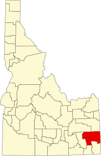
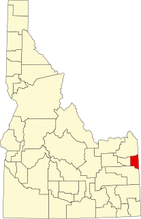
This is a list of the National Register of Historic Places listings in Bonneville County, Idaho.

National Register of Historic Places listings in Boise County, Idaho

This is a list of the National Register of Historic Places listings in Boise County, Idaho.

National Register of Historic Places listings in Benewah County, Idaho

This is a list of the National Register of Historic Places listings in Benewah County, Idaho.

National Register of Historic Places listings in Bear Lake County, Idaho

This is a list of the National Register of Historic Places listings in Bear Lake County, Idaho.

National Register of Historic Places listings in Bannock County, Idaho

This is a list of the National Register of Historic Places listings in Bannock County, Idaho.

National Register of Historic Places listings in Camas County, Idaho

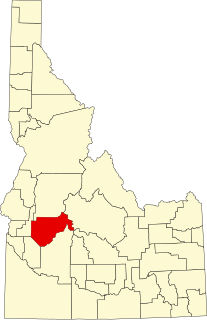
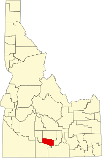
This is a detailed table of the National Register of Historic Places listing in Camas County, Idaho.

National Register of Historic Places listings in Caribou County, Idaho

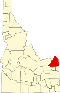
This is a list of the National Register of Historic Places listings in Caribou County, Idaho.

National Register of Historic Places listings in Clark County, Idaho

This is a list of the National Register of Historic Places listings in Clark County, Idaho.

National Register of Historic Places listings in Fremont County, Idaho

This is a list of the National Register of Historic Places listings in Fremont County, Idaho.

National Register of Historic Places listings in Gem County, Idaho

This is a list of the National Register of Historic Places listings in Gem County, Idaho.

National Register of Historic Places listings in Jefferson County, Idaho

This is a list of the National Register of Historic Places listings in Jefferson County, Idaho.

National Register of Historic Places listings in Jerome County, Idaho

This is a list of the National Register of Historic Places listings in Jerome County, Idaho.

National Register of Historic Places listings in Lincoln County, Idaho

This is a list of the National Register of Historic Places listings in Lincoln County, Idaho.

National Register of Historic Places listings in Washington County, Idaho

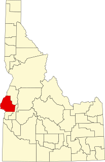
This is a list of the National Register of Historic Places listings in Washington County, Idaho.

National Register of Historic Places listings in Valley County, Idaho

This is a list of the National Register of Historic Places listings in Valley County, Idaho.

National Register of Historic Places listings in Payette County, Idaho

This is a list of the National Register of Historic Places listings in Payette County, Idaho.

National Register of Historic Places listings in Teton County, Idaho

This is a list of the National Register of Historic Places listings in Teton County, Idaho.

National Register of Historic Places listings in Oneida County, Idaho

This is a list of the National Register of Historic Places listings in Oneida County, Idaho.

National Register of Historic Places listings in Minidoka County, Idaho

This is a list of the National Register of Historic Places listings in Minidoka County, Idaho.

References

  1. The latitude and longitude information provided in this table was derived originally from the National Register Information System, which has been found to be fairly accurate for about 99% of listings. Some locations in this table may have been corrected to current GPS standards.
  2. "National Register of Historic Places: Weekly List Actions". National Park Service . Retrieved March 29, 2009.
  3. National Park Service, United States Department of the Interior, "National Register of Historic Places: Weekly List Actions", retrieved June 10, 2022.
  4. Numbers represent an alphabetical ordering by significant words. Various colorings, defined here, differentiate National Historic Landmarks and historic districts from other NRHP buildings, structures, sites or objects.
  5. "National Register Information System". National Register of Historic Places . National Park Service. April 24, 2008.
  6. The eight-digit number below each date is the number assigned to each location in the National Register Information System database, which can be viewed by clicking the number.