Coolin, Idaho

Last updated

Coolin, Idaho
Coolin, Idaho's unique Leonard Paul Store Photo P. Cox.jpg
Coolins, March 2020
USA Idaho location map.svg
Red pog.svg
Coolin
Location within Idaho
Usa edcp location map.svg
Red pog.svg
Coolin
Location within the United States
Coordinates: 48°28′47″N116°50′58″W / 48.47972°N 116.84944°W / 48.47972; -116.84944
Country United States
State Idaho
County Bonner

Coolin is an unincorporated community in Bonner County, Idaho, United States. [1] The nearest school district is the West Bonner School District. [2]

Contents

Geography

Coolin is situated at the southeast end of Priest Lake, at an elevation is 2,490 feet above sea level.

Climate

This climatic region is typified by large seasonal temperature differences, with warm to hot (and often humid) summers and cold (sometimes severely cold) winters. According to the Köppen Climate Classification system, Coolin has a humid continental climate, abbreviated "Dfb" on climate maps. [3]

History

Andy Coolin opened a post office at the southern end of Priest Lake in 1893, thereby giving his name to the nascent community. Hopes were high for a mining bonanza in the area and for a future link to the railroad, 28 miles away. [4] To accommodate travelers and prospectors, Walt Williams, an employee of the Great Northern Railroad, built a two-story log hotel, the Northern Inn, in 1900.

In 1903 Andy Coolin received a patent on a homestead, planning to leverage his land into a financial empire. Coolin formed the Priest Lake Town Site and Improvement Company with his brother and other local investors in 1907. By that time Spokane businessman Joseph Slee already operated a steamboat out of Coolin connecting the lake with supplies, mail, and transportation. In 1906, Leonard Paul opened a general merchandise store in the tiny village; Ida Handy opened the Idaho Inn in 1908.

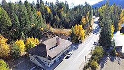
When mining riches failed to pan out and Andy Coolin's efforts to lure the railway to Priest Lake came to naught, the village of Coolin became a center for summer vacationers and services, including a sawmill, store, hotel, ranger station, docks, and steamboat service. Today the Old Northern Inn, the Leonard Paul Store, and the one room schoolhouse, built in 1916 and now the Coolin Civic Association, remain as landmarks from those early days.

Coolin's population was estimated at 100 in 1960. [5]

Politics

Presidential elections results
Previous presidential elections results [6]
Year Republican Democratic Third parties
2020 62.9%7333.6% 393.4% 4
2016 57.7%3137.2% 205.1% 3
Statewide elections results
Previous statewide elections results [7]
Year Republican Democratic Third parties
2020 Senate 65.2%7533% 381.7% 2
2018 Governor 56.8%2941.9% 211.4% 1
2018 Lt. Governor54.4%2845.6% 230% 0
2018 Attorney General55.2%2744.8% 220% 0
2016 Senate 61.6%3335.8% 192.5% 1

See also

Related Research Articles

<span class="mw-page-title-main">Idaho</span> U.S. state

Idaho is a state in the Mountain West subregion of the United States. It shares a small portion of the Canada–United States border to the north, with the province of British Columbia. It borders Montana and Wyoming to the east, Nevada and Utah to the south, and Washington and Oregon to the west. The state's capital and largest city is Boise. With an area of 83,570 square miles (216,400 km2), Idaho is the 14th largest state by land area. With a population of approximately 1.8 million, it ranks as the 13th least populous and the 6th least densely populated of the 50 U.S. states.

<span class="mw-page-title-main">Bonner County, Idaho</span> County in Idaho, United States

Bonner County is a county in the northern part of the U.S. state of Idaho. As of the 2020 census, the population was 47,110. The county seat and largest city is Sandpoint. Partitioned from Kootenai County and established in 1907, it was named for Edwin L. Bonner, a ferry operator.

<span class="mw-page-title-main">Sandpoint, Idaho</span> City in Idaho, United States

Sandpoint is the largest city in, and the county seat of, Bonner County, Idaho, United States. Its population was 8,639 at the 2020 census.

<span class="mw-page-title-main">Bonners Ferry, Idaho</span> City in Idaho

Bonners Ferry is the largest of two cities in and the county seat of Boundary County, Idaho, United States. The population was 2,543 at the 2010 census.

<span class="mw-page-title-main">Coeur d'Alene, Idaho</span> City in Idaho, United States

Coeur d'Alene is a city and the county seat of Kootenai County, Idaho, United States. It is the largest city in North Idaho and the principal city of the Coeur d'Alene Metropolitan Statistical Area. The population was 54,628 at the 2020 census. Coeur d'Alene is a satellite city of Spokane, which is located about thirty miles (50 km) to the west in the state of Washington. The two cities are the key components of the Spokane–Coeur d'Alene Combined Statistical Area, of which Coeur d'Alene is the third-largest city. The city is situated on the north shore of the 25-mile (40 km) long Lake Coeur d'Alene and to the west of the Coeur d'Alene Mountains. Locally, Coeur d'Alene is known as the "Lake City," or simply called by its initials, "CDA."

<span class="mw-page-title-main">Bonner-West Riverside, Montana</span> CDP in Montana, United States

Bonner-West Riverside is a census-designated place (CDP) in Missoula County, Montana, United States, including the unincorporated communities of Bonner, Milltown, West Riverside, and Pinegrove. It is part of the Missoula, Montana Metropolitan Statistical Area. The population was 1,663 at the 2010 census, a decline from its population of 1,693 in 2000.

<span class="mw-page-title-main">Greenville, Maine</span> Town in the state of Maine, United States

Greenville is a town in Piscataquis County, Maine, United States. The population was 1,437 at the 2020 census. The town is centered on the lower end of Moosehead Lake, the largest body of fresh water in the state. Greenville is the historic gateway to the north country and a center for outdoor recreation in the area. Greenville High School, with 89 students, was ranked as the third best high school in Maine and one of the top 1,000 in the US in 2010.

<span class="mw-page-title-main">Priest Lake</span>

Priest Lake is a lake in Idaho, United States, in the northernmost portion of the Idaho Panhandle, 80 miles (130 km) northeast of Spokane, Washington. The northern end of the lake extends to within 15 miles (24 km) of the Canada–United States border. The primary lake, lower Priest, is 19 miles (31 km) long and over 300 feet (91 m) deep. Upper Priest is connected by a 2.5 miles (4.0 km) thoroughfare to lower Priest.

<span class="mw-page-title-main">Idaho panhandle</span> Region of the U.S. state of Idaho

The Idaho panhandle—locally known as North Idaho—is a salient region of the U.S. state of Idaho encompassing the state's 10 northernmost counties: Benewah, Bonner, Boundary, Clearwater, Idaho, Kootenai, Latah, Lewis, Nez Perce, and Shoshone. The panhandle is bordered by the state of Washington to the west, Montana to the east, and the Canadian province of British Columbia to the north. The Idaho panhandle, along with Eastern Washington, makes up the region known as the Inland Northwest, headed by its largest city, Spokane, Washington.

<span class="mw-page-title-main">Hiawatha, Utah</span> Unincorporated Community in Utah, United States

Hiawatha is an unincorporated community and near-ghost town, formerly a coal mining town in southwestern Carbon County, Utah, United States. While the town's former corporate limits were almost entirely within Carbon County, the western part was within the Manti-La Sal National Forest and a very small part extended west into Emery County.

<span class="mw-page-title-main">Don Samuelson</span> American politician

Donald William Samuelson was an American Republican politician who served as the 25th governor of Idaho, from 1967 to 1971. He is the state's most recent incumbent governor to lose a re-election bid (1970).

<span class="mw-page-title-main">Avery, Idaho</span> Unincorporated community in the state of Idaho, United States

Avery is a small unincorporated community in the northwest United States, located in the St. Joe River Valley in Shoshone County, Idaho. Avery is located in the middle of the St. Joe District of the Idaho Panhandle National Forest, and is a tourist attraction in the Idaho Panhandle known for its wilderness and outdoor recreation. It is upstream and east of St. Maries, the county seat of Benewah County.

<span class="mw-page-title-main">Clarkia, Idaho</span> Unincorporated community in the state of Idaho, United States

Clarkia is a small unincorporated community in the southwestern corner of Shoshone County, Idaho. It is surrounded by publicly and privately managed forest lands of Douglas-fir, Ponderosa Pine, and Western Larch. Located just to the east of State Highway 3, the town is in the drainage area of the West Fork of the St. Maries River.

<span class="mw-page-title-main">Burke, Idaho</span> Ghost town in Idaho, United States

Burke is a ghost town in Shoshone County, Idaho, United States, established in 1887. Once a thriving silver, lead and zinc mining community, the town saw significant decline in the mid-twentieth century after the closure of several mines.

Horsefly is an unincorporated community on the northwest shore of the Horsefly River, in the Cariboo region of central British Columbia. The location, via BC Highway 97, Likely Rd, and Horsefly Rd, is about 67 kilometres (42 mi) northeast of Williams Lake, and by road 22 kilometres (14 mi) south of Quesnel Lake.

<span class="mw-page-title-main">Clear Creek, Utah</span> Census-designated place in Utah, United States

Clear Creek is a census-designated place on the western edge of Carbon County, Utah, United States. It is located at the south end of State Route 96 and the Pleasant Valley Branch of the Union Pacific Railroad.

McLeese Lake is an unincorporated community on British Columbia Highway 97 in the Cariboo region of the Central Interior of British Columbia, Canada. It is named for the lake of the same name, which itself was named for Robert McLeese, a pioneer storekeeper, hotelier and steamboat owner and also politician.

<span class="mw-page-title-main">Porthill-Rykerts Border Crossing</span>

The Porthill-Rykerts Border Crossing connects the town of Bonners Ferry, Idaho with Creston, British Columbia on the Canada–US border. Idaho State Highway 1 on the American side joins British Columbia Highway 21 on the Canadian side, which continues north towards Creston. The Porthill-Rykerts Border Crossing is used as the American Port only; Rykerts acts as the Canadian Crossing.

The Old Northern Inn is the oldest hostelry in northern Idaho. Located on Priest Lake in Coolin, Idaho, the two-story log hotel was built in 1900 by Walt Williams, an employee of the Great Northern Railroad. One of a number of lodges created to attract more passengers to the rail line, the Northern Inn is the only one that remains from the early days of Idaho statehood when mining, timber, and tourism businesses were beginning to develop around Priest Lake.

<span class="mw-page-title-main">Vallée-des-Rivières</span> Town in New Brunswick, Canada

Vallée-des-Rivières is a town in the Canadian province of New Brunswick. It was formed through the 2023 New Brunswick local governance reforms.

References

  1. U.S. Geological Survey Geographic Names Information System: Coolins
  2. West Bonner Schools
  3. Climate Summary for Coolin, Idaho
  4. Wild Place, A History of Priest Lake, Idaho by Kris Runberg Smith with Tom Weitz
  5. World Book Encyclopedia. Vol. I. Field Enterprises Corporation. 1960. p. 27.
  6. "Dave's Redistricting". davesredistricting.org. Retrieved July 7, 2021.
  7. "Dave's Redistricting". davesredistricting.org. Retrieved July 7, 2021.

Commons-logo.svg Media related to Coolin, Idaho at Wikimedia Commons