National Register of Historic Places listings in Blaine County, Idaho

Last updated

Location of Blaine County in Idaho Map of Idaho highlighting Blaine County.svg
Location of Blaine County in Idaho

This is a list of the National Register of Historic Places listings in Blaine County, Idaho.

Contents

This is intended to be a complete list of the properties and districts on the National Register of Historic Places in Blaine County, Idaho, United States. Latitude and longitude coordinates are provided for many National Register properties and districts; these locations may be seen together in a map. [1]

There are 23 properties and districts listed on the National Register in the county. More may be added; properties and districts nationwide are added to the Register weekly. [2]


    This National Park Service list is complete through NPS recent listings posted July 28, 2023. [3]

Map all coordinates using: OpenStreetMap

Current listings

[4] Name on the Register [5] ImageDate listed [6] Location City or townDescription
1 Bald Mountain Hot Springs November 17, 1982
(#82000320)
Main and 1st St.
43°40′44″N114°21′42″W / 43.678889°N 114.361667°W / 43.678889; -114.361667 (Bald Mountain Hot Springs)
Ketchum
2 Bellevue Historic District
Bellevue Historic District Bellevue Old City Hall ID1.jpg
Bellevue Historic District
June 16, 1982
(#82002506)
Roughly bounded by U.S. Route 93, Cedar, 4th, and Oak Sts.
43°27′51″N114°15′29″W / 43.464167°N 114.258056°W / 43.464167; -114.258056 (Bellevue Historic District)
Bellevue
3 Blaine County Courthouse
Blaine County Courthouse Blaine County Courthouse, Hailey ID1.jpg
Blaine County Courthouse
February 17, 1978
(#78001050)
1st and Croy Sts.
43°31′08″N114°18′42″W / 43.518889°N 114.311667°W / 43.518889; -114.311667 (Blaine County Courthouse)
Hailey
4 Eben S. and Elizabeth S. Chase House
Eben S. and Elizabeth S. Chase House Chase House2 NRHP 09000292 Blaine County, ID.jpg
Eben S. and Elizabeth S. Chase House
May 5, 2009
(#09000292)
203 E. Bullion St.
43°31′14″N114°18′47″W / 43.520633°N 114.312922°W / 43.520633; -114.312922 (Eben S. and Elizabeth S. Chase House)
Hailey
5 Cold Springs Pegram Truss Railroad Bridge
Cold Springs Pegram Truss Railroad Bridge Cold-Springs-Bridge.JPG
Cold Springs Pegram Truss Railroad Bridge
July 25, 1997
(#97000762)
Over the Big Wood River 0.5 miles south of the junction of U.S. Route 93 and State Highway 367
43°39′15″N114°20′55″W / 43.654167°N 114.348611°W / 43.654167; -114.348611 (Cold Springs Pegram Truss Railroad Bridge)
Ketchum
6 Emmanuel Episcopal Church
Emmanuel Episcopal Church Emmanuel Episcopal Hailey ID1.jpg
Emmanuel Episcopal Church
October 5, 1977
(#77000457)
101 2nd Ave., S.
43°31′13″N114°18′44″W / 43.520278°N 114.312222°W / 43.520278; -114.312222 (Emmanuel Episcopal Church)
Hailey
7 Fish Creek Dam December 29, 1978
(#78003437)
Northeast of Carey
43°25′23″N113°49′54″W / 43.423061°N 113.831669°W / 43.423061; -113.831669 (Fish Creek Dam)
Carey
8 J. C. Fox Building
J. C. Fox Building J.C. Fox Building Hailey ID1.jpg
J. C. Fox Building
March 31, 1983
(#83000279)
S. Main St.
43°31′08″N114°18′51″W / 43.518889°N 114.314167°W / 43.518889; -114.314167 (J. C. Fox Building)
Hailey
9 Fox–Worswick House
Fox-Worswick House Fox-Worswick House NRHP 11000613 Blaine County, ID.jpg
Fox–Worswick House
August 31, 2011
(#11000613)
119 E. Bullion St.
43°31′15″N114°18′48″W / 43.52074°N 114.31341°W / 43.52074; -114.31341 (Fox–Worswick House)
Hailey
10 Gimlet Pegram Truss Railroad Bridge
Gimlet Pegram Truss Railroad Bridge Gimlet-Bridge.jpg
Gimlet Pegram Truss Railroad Bridge
July 25, 1997
(#97000757)
Over the Big Wood River 0.5 miles south of the junction of U.S. Route 93 and East Fork Wood River Rd.
43°35′53″N114°20′43″W / 43.598056°N 114.345278°W / 43.598056; -114.345278 (Gimlet Pegram Truss Railroad Bridge)
Ketchum
11 Greenhow and Rumsey Store Building
Greenhow and Rumsey Store Building Greenhow And Rumsey Store Building NRHP 83000280 Blaine County, ID.jpg
Greenhow and Rumsey Store Building
August 18, 1983
(#83000280)
180 N. Main St.
43°40′48″N114°21′47″W / 43.68°N 114.363056°W / 43.68; -114.363056 (Greenhow and Rumsey Store Building)
Ketchum
12 Hailey Masonic Lodge
Hailey Masonic Lodge Hailey - Masonic Lodge ID1.jpg
Hailey Masonic Lodge
September 12, 2008
(#08000869)
100 S. 2nd Ave.
43°31′14″N114°18′47″W / 43.52059°N 114.31294°W / 43.52059; -114.31294 (Hailey Masonic Lodge)
Hailey
13 Hailey Methodist Episcopal Church
Hailey Methodist Episcopal Church Hailey Methodist Episcopal Church NRHP 100000560 Blaine County, ID.jpg
Hailey Methodist Episcopal Church
January 24, 2017
(#100000560)
200 2nd Ave., S.
43°31′11″N114°18′43″W / 43.519611°N 114.311868°W / 43.519611; -114.311868 (Hailey Methodist Episcopal Church)
Hailey
14 Ernest and Mary Hemingway House March 13, 2015
(#13001073)
Address restricted [7]
Ketchum
15 Ketchum Ranger District Administrative Site
Ketchum Ranger District Administrative Site Site overview from the east. The three warehouse buildings are located in the foreground. - Ketchum Administrative Site, 117 and 119 River Street, Ketchum, Blaine County, ID HABS ID,7-KET,1-2.tif
Ketchum Ranger District Administrative Site
February 9, 2007
(#07000005)
131/171 River St.
43°40′42″N114°21′45″W / 43.678333°N 114.3625°W / 43.678333; -114.3625 (Ketchum Ranger District Administrative Site)
Ketchum
16 Henry Miller House May 30, 1975
(#75000624)
South of Bellevue off U.S. Route 93
43°26′47″N114°15′16″W / 43.446389°N 114.254444°W / 43.446389; -114.254444 (Henry Miller House)
Bellevue
17 Homer Pound House
Homer Pound House Homer Pound House2 NRHP 78001051 Blaine County, ID.jpg
Homer Pound House
December 28, 1978
(#78001051)
314 2nd Ave., S.
43°31′05″N114°18′35″W / 43.518056°N 114.309722°W / 43.518056; -114.309722 (Homer Pound House)
Hailey
18 Proctor Mountain Ski Lift
Proctor Mountain Ski Lift The chairlift at Ruud - Proctor Mountain in Sun Valley, Idaho USA (one of the first chairlifts ever).jpg
Proctor Mountain Ski Lift
January 20, 1980
(#80001294)
Trail Creek
43°42′23″N114°20′06″W / 43.706389°N 114.335°W / 43.706389; -114.335 (Proctor Mountain Ski Lift)
Sun Valley
19 The Rialto Hotel
The Rialto Hotel Hailey-Rialto Hotel ID1.jpg
The Rialto Hotel
December 30, 2009
(#09001162)
201 S. Main St.
43°31′14″N114°18′58″W / 43.520575°N 114.316097°W / 43.520575; -114.316097 (The Rialto Hotel)
Hailey
20 St. Charles of the Valley Catholic Church and Rectory
St. Charles of the Valley Catholic Church and Rectory Saint Charles Of The Valley Catholic Church And Rectory NRHP 82000321 Blaine County, ID.jpg
St. Charles of the Valley Catholic Church and Rectory
November 17, 1982
(#82000321)
Pine and S. 1st Sts.
43°31′02″N114°18′42″W / 43.517222°N 114.311667°W / 43.517222; -114.311667 (St. Charles of the Valley Catholic Church and Rectory)
Hailey
21 Sawtooth City April 4, 1975
(#75000625)
Southeast of Alturas Lake [8]
43°53′48″N114°50′25″W / 43.8967°N 114.8403°W / 43.8967; -114.8403 (Sawtooth City)
Sun Valley
22 W. H. Watt Building
W. H. Watt Building W.H. Watt Bldg Hailley ID2.jpg
W. H. Watt Building
March 31, 1983
(#83000281)
120 N. Main St.
43°31′14″N114°18′53″W / 43.520556°N 114.314722°W / 43.520556; -114.314722 (W. H. Watt Building)
Hailey
23 Werthheimer Building
Werthheimer Building Werthheimer Bldg Hailey ID1.jpg
Werthheimer Building
September 12, 1985
(#85002160)
101 S. Main St.
43°31′10″N114°18′53″W / 43.519444°N 114.314722°W / 43.519444; -114.314722 (Werthheimer Building)
Hailey

Former listings

[4] Name on the RegisterImageDate listedDate removedLocationCity or townDescription
1 Hiawatha Hotel July 15, 1974
(#74000733)
January 31, 1986First Ave. and Croy St.
Hailey Burned down in January 1979.

See also

Related Research Articles

<span class="mw-page-title-main">National Register of Historic Places listings in Lake and Peninsula Borough, Alaska</span>

This is a list of the National Register of Historic Places listings in Lake and Peninsula Borough, Alaska, United States.

<span class="mw-page-title-main">National Register of Historic Places listings in Bonneville County, Idaho</span>

This is a list of the National Register of Historic Places listings in Bonneville County, Idaho.

<span class="mw-page-title-main">National Register of Historic Places listings in Boundary County, Idaho</span>

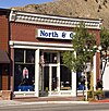
This is a list of the National Register of Historic Places listings in Boundary County, Idaho.

<span class="mw-page-title-main">National Register of Historic Places listings in Clark County, Idaho</span>

This is a list of the National Register of Historic Places listings in Clark County, Idaho.

<span class="mw-page-title-main">National Register of Historic Places listings in Clearwater County, Idaho</span>

This is a list of the National Register of Historic Places listings in Clearwater County, Idaho.

<span class="mw-page-title-main">National Register of Historic Places listings in Custer County, Idaho</span>

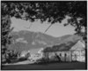
This is a list of the National Register of Historic Places listings in Custer County, Idaho.

<span class="mw-page-title-main">National Register of Historic Places listings in Franklin County, Idaho</span>

This is a list of the National Register of Historic Places listings in Franklin County, Idaho.

<span class="mw-page-title-main">National Register of Historic Places listings in Idaho County, Idaho</span>

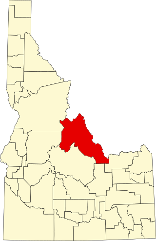
This is a list of the National Register of Historic Places listings in Idaho County, Idaho.

<span class="mw-page-title-main">National Register of Historic Places listings in Lemhi County, Idaho</span>

This is a list of the National Register of Historic Places listings in Lemhi County, Idaho.

<span class="mw-page-title-main">National Register of Historic Places listings in Lewis County, Idaho</span>

This is a list of the National Register of Historic Places listings in Lewis County, Idaho.

<span class="mw-page-title-main">National Register of Historic Places listings in Power County, Idaho</span>

This is a list of the National Register of Historic Places listings in Power County, Idaho.

<span class="mw-page-title-main">National Register of Historic Places listings in Owyhee County, Idaho</span>

This is a list of the National Register of Historic Places listings in Owyhee County, Idaho.

<span class="mw-page-title-main">National Register of Historic Places listings in Lewis and Clark County, Montana</span>

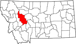
This is a list of the National Register of Historic Places listings in Lewis and Clark County, Montana.

<span class="mw-page-title-main">National Register of Historic Places listings in Warren County, Mississippi</span>

This is a list of the National Register of Historic Places listings in Warren County, Mississippi.

<span class="mw-page-title-main">National Register of Historic Places listings in Edgecombe County, North Carolina</span>

This list includes properties and districts listed on the National Register of Historic Places in Edgecombe County, North Carolina, United States. Click the "Map of all coordinates" link to the right to view a Google map of all properties and districts with latitude and longitude coordinates in the table below.

<span class="mw-page-title-main">National Register of Historic Places listings in Pitt County, North Carolina</span>

This list includes properties and districts listed on the National Register of Historic Places in Pitt County, North Carolina. Click the "Map of all coordinates" link to the right to view an online map of all properties and districts with latitude and longitude coordinates in the table below.

<span class="mw-page-title-main">National Register of Historic Places listings in Dare County, North Carolina</span>

This list includes properties and districts listed on the National Register of Historic Places in Dare County, North Carolina. Click the "Map of all coordinates" link to the right to view a Google map of all properties and districts with latitude and longitude coordinates in the table below.

<span class="mw-page-title-main">National Register of Historic Places listings in Hutchinson County, South Dakota</span>

This is a list of the National Register of Historic Places listings in Hutchinson County, South Dakota.

<span class="mw-page-title-main">National Register of Historic Places listings in Blaine County, Montana</span>

This is a list of the National Register of Historic Places listings in Blaine County, Montana. It is intended to be a complete list of the properties and districts on the National Register of Historic Places in Blaine County, Montana, United States. The locations of National Register properties and districts for which the latitude and longitude coordinates are included below, may be seen in a map.

<span class="mw-page-title-main">National Register of Historic Places listings in Armstrong County, Texas</span>

This is a list of the National Register of Historic Places listings in Armstrong County, Texas.

References

  1. The latitude and longitude information provided in this table was derived originally from the National Register Information System, which has been found to be fairly accurate for about 99% of listings. Some locations in this table may have been corrected to current GPS standards.
  2. "National Register of Historic Places: Weekly List Actions". National Park Service . Retrieved March 29, 2009.
  3. National Park Service, United States Department of the Interior, "National Register of Historic Places: Weekly List Actions", retrieved July 28, 2023.
  4. 1 2 Numbers represent an alphabetical ordering by significant words. Various colorings, defined here, differentiate National Historic Landmarks and historic districts from other NRHP buildings, structures, sites or objects.
  5. "National Register Information System". National Register of Historic Places . National Park Service. April 24, 2008.
  6. The eight-digit number below each date is the number assigned to each location in the National Register Information System database, which can be viewed by clicking the number.
  7. Federal and state laws and practices restrict general public access to information regarding the specific location of this resource. In some cases, this is to protect archeological sites from vandalism, while in other cases it is restricted at the request of the owner. See: Knoerl, John; Miller, Diane; Shrimpton, Rebecca H. (1990), Guidelines for Restricting Information about Historic and Prehistoric Resources, National Register Bulletin, National Park Service, U.S. Department of the Interior, OCLC   20706997 .
  8. Coordinates derived from its GNIS feature record and the map [ permanent dead link ] attached to the record; the NRIS lists the site as "Address Restricted"