
Elmore County is a county in the U.S. state of Idaho. As of the 2020 census, the population was 28,666. The largest city and county seat is Mountain Home.

Blaine County is a county in the U.S. state of Idaho. As of the 2020 United States Census, the population was 24,272. The county seat and largest city is Hailey. It is also home to the Sun Valley ski resort, adjacent to Ketchum.

Bellevue is a city in Blaine County in the central part of the U.S. state of Idaho. The population was 2,287 at the 2010 census, up from 1,876 in 2000.
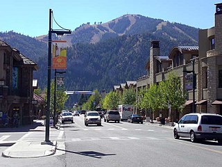
Ketchum is a city in Blaine County, Idaho, United States. Located in the central part of the state, the population was 3,555 at the 2020 census, up from 2,689 in 2010. Located in the Wood River Valley, Ketchum is adjacent to Sun Valley and the communities share many resources: both sit in the same valley beneath Bald Mountain, with its skiing. The city also draws tourists to its fishing, hiking, trail riding, tennis, shopping, art galleries, and more. The airport for Ketchum, Friedman Memorial Airport, is approximately 15 miles (24 km) south in Hailey.
Burley is a city in Cassia and Minidoka counties in southern Idaho, United States. The population was 11,704 at the 2020 census, up from 10,345 in 2010. The city is the county seat of Cassia County.

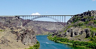
Twin Falls is the county seat and largest city of Twin Falls County, Idaho, United States. The city had a population of 51,807 as of the 2020 census. In the Magic Valley region, Twin Falls is the largest city in a 100-mile (160 km) radius, and is the regional commercial center for south-central Idaho and northeastern Nevada. It is the principal city of the Twin Falls metropolitan statistical area, which officially includes the entirety of Twin Falls and Jerome Counties. The border town resort community of Jackpot, Nevada, 50 mi (80 km) south at the state line, is unofficially considered part of the greater Twin Falls area. Located on a broad plain at the south rim of the Snake River Canyon, Twin Falls, is where daredevil Evel Knievel attempted to jump across the canyon in 1974 on a steam-powered rocket. The jump site is northeast of central Twin Falls, midway between Shoshone Falls and the Perrine Bridge.

Salmon–Challis National Forest is located in east central sections of the U.S. state of Idaho. At 4,235,940 acres it is one of the largest national forests in the lower 48 states and also has most of the land area of the Frank Church–River of No Return Wilderness, which is the largest wilderness area south of Alaska.
The Magic Valley, also known as South Central Idaho, is a region in south-central Idaho constituting Blaine, Camas, Cassia, Gooding, Jerome, Lincoln, Minidoka, and Twin Falls counties. It is particularly associated with the agricultural region in the Snake River Plain located in the area. The northern Magic Valley region — particularly Blaine and Camas Counties — is also known as the Wood River Valley after the Big Wood River.

The Wood River Valley is a region in south-central Idaho. Located in Blaine County, it is named after the Big Wood and Little Wood Rivers, which flow through the area.

Picabo is an unincorporated community in Blaine County, Idaho, United States.

The Big Wood River is a 137-mile-long (220 km) river in central Idaho, United States, that is a tributary of the Malad River.
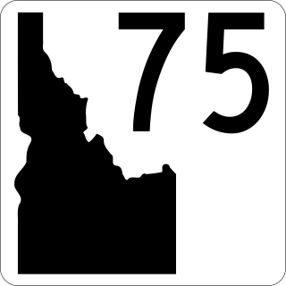
State Highway 75 is a two-lane highway in the western United States that travels through the Sawtooth Valley of central Idaho. The highway's southern terminus is in Shoshone, and its northern is near Challis. It is designated as one of Idaho's scenic byways and provides access to Sawtooth National Recreation Area and primarily follows the Big Wood River in the south and the main Salmon River in the north, divided by Galena Summit.

The Gimlet Bridge is a 217-foot, single span Pegram truss railroad bridge in Blaine County, Idaho. It is 17 feet (5.2 m) and is supported by concrete piers at each end. It provides 21 feet (6.4 m) clearance above a roadbed below.
Laclede is an unincorporated community in Bonner County, Idaho, United States. Laclede is located on U.S. Route 2 at the intersection of Riley Creek and the Pend Oreille River. Laclede has a post office with ZIP code 83841.
Kelly Mountain, with a summit elevation of 8,826 feet (2,690 m), is a peak in the Smoky Mountains of Idaho. The peak is located in Blaine County on the border of Sawtooth National Forest and Bureau of Land Management land. It is located in the watersheds of Elk, Kelly, and Wolftone creeks, all in the watershed of the Big Wood River. It is about 5.8 mi (9.3 km) southeast of Buttercup Mountain. No roads or trails go to the summit.
Griffin Butte, at 8,411 feet (2,564 m) above sea level is a peak in the Smoky Mountains of Idaho. The peak is located in Sawtooth National Forest in Blaine County northwest of Ketchum. It is located in the watershed of the Big Wood River. It is about 1.75 mi (2.82 km) west of Idaho State Highway 75. No roads or trails go to the summit.

Lost River Peak, also known as Lost River Mountain, at 12,078 feet (3,681 m) above sea level is the sixth-highest peak in the U.S. state of Idaho and the fifth-highest in the Lost River Range. The peak is located in Salmon-Challis National Forest in Custer County. It is 1.8 mi (2.9 km) southeast of Mount Breitenbach, its line parent.
No Regret Peak, at 11,972 feet (3,649 m) above sea level, is the eleventh-highest peak in the U.S. state of Idaho and the ninth-highest in the Lost River Range. The peak is located in Salmon-Challis National Forest in Custer County. It is 0.85 mi (1.37 km) northwest of Mount Breitenbach, its line parent, 0.8 mi (1.3 km) northeast of Donaldson Peak, and 1.3 mi (2.1 km) east of Mount Church.
Springdale is an unincorporated community in Cassia County in the U.S. state of Idaho. The community is along State Highway 81, 5 mi (8.0 km) east of Burley and 3 mi (4.8 km) west of Declo. The Snake River flows immediately north of Springdale.
Jackson is an unincorporated community in Minidoka County and Cassia County in the U.S. state of Idaho. The community is located 4 mi (6.4 km) east of Rupert and 13 mi (21 km) northeast of Burley. The Snake River flows immediately northwest of Jackson.


