Paris, Idaho

Last updated

Paris, Idaho
Paris, Idaho - Stone Tabernacle 1889.JPG
Stone Tabernacle (Bear Lake Stake Tabernacle), c. 1889
Bear Lake County Idaho Incorporated and Unincorporated areas Paris Highlighted 1660580.svg
Location of Paris in Bear Lake County, Idaho.
Usa edcp location map.svg
Red pog.svg
Paris, Idaho
Location in the United States
Coordinates: 42°13′40″N111°23′58″W / 42.22778°N 111.39944°W / 42.22778; -111.39944
Country United States
State Idaho
County Bear Lake
Area
[1]
  Total3.52 sq mi (9.11 km2)
  Land3.49 sq mi (9.03 km2)
  Water0.03 sq mi (0.07 km2)
Elevation
5,965 ft (1,818 m)
Population
 (2010) [2]
  Total513
  Estimate 
(2019) [3]
521
  Density149.37/sq mi (57.68/km2)
Time zone UTC-7 (Mountain (MST))
  Summer (DST) UTC-6 (MDT)
ZIP codes
83261, 83287
Area code(s) 208, 986
FIPS code 16-60580
GNIS feature ID0388197

Paris is a city and county seat of Bear Lake County, Idaho, United States. Located on the western side of the Bear Lake Valley, the city's population was 513 at the 2010 census, down from 576 in 2000. [4] Paris was settled on September 26, 1863, by pioneer settlers of the Church of Jesus Christ of Latter-day Saints.

Contents

Paris was settled by a group of dedicated Mormons led by Charles C Rich. During the early years, pioneers suffered difficulties with the harsh cold climate.

Paris is the location of the Bear Lake Stake Tabernacle, a sandstone church designed by Joseph Don Carlos Young and built between 1884 and 1889. It seats around 1,400 people.

History

Paris was founded by Mormon pioneers, under the direction of Charles C. Rich on September 29, 1863. The settlers believed the town to be located in Utah until a survey in 1872 showed that it was in Idaho.[ citation needed ]

Geography

According to the United States Census Bureau, the city has a total area of 3.51 square miles (9.09 km2), of which, 3.48 square miles (9.01 km2) is land and 0.03 square miles (0.08 km2) is water. [5]

Paris lies in a high valley of the Rocky Mountains, at nearly 6,000 feet (1,830 m) in elevation.

Climate

According to the Köppen climate classification, Paris has a warm-summer humid continental climate (Köppen climate classification: Dfb). Due to the high elevation, cold winters, late springs and mild summers are the norm for Paris and the area. Most of the surrounding country is used for ranching.

Climate data for Paris, Idaho, 1991–2020 simulated normals (5961 ft elevation)
MonthJanFebMarAprMayJunJulAugSepOctNovDecYear
Mean daily maximum °F (°C)30.0
(−1.1)
32.7
(0.4)
42.1
(5.6)
52.5
(11.4)
62.6
(17.0)
72.9
(22.7)
82.9
(28.3)
81.9
(27.7)
72.0
(22.2)
57.7
(14.3)
42.6
(5.9)
31.5
(−0.3)
55.1
(12.8)
Daily mean °F (°C)19.0
(−7.2)
20.8
(−6.2)
30.4
(−0.9)
39.9
(4.4)
49.1
(9.5)
57.7
(14.3)
65.7
(18.7)
64.4
(18.0)
54.9
(12.7)
43.2
(6.2)
31.1
(−0.5)
21.0
(−6.1)
41.4
(5.2)
Mean daily minimum °F (°C)8.1
(−13.3)
9.0
(−12.8)
18.7
(−7.4)
27.5
(−2.5)
35.6
(2.0)
42.4
(5.8)
48.4
(9.1)
46.9
(8.3)
37.8
(3.2)
28.6
(−1.9)
19.8
(−6.8)
10.6
(−11.9)
27.8
(−2.3)
Average precipitation inches (mm)1.66
(42.05)
1.43
(36.27)
1.27
(32.27)
1.47
(37.34)
2.02
(51.41)
1.16
(29.38)
0.63
(15.90)
0.84
(21.42)
1.24
(31.46)
1.40
(35.60)
1.19
(30.23)
1.45
(36.87)
15.76
(400.2)
Average dew point °F (°C)11.8
(−11.2)
13.3
(−10.4)
20.8
(−6.2)
25.5
(−3.6)
32.7
(0.4)
37.8
(3.2)
41.4
(5.2)
38.7
(3.7)
32.9
(0.5)
26.4
(−3.1)
20.3
(−6.5)
13.8
(−10.1)
26.3
(−3.2)
Source: Prism Climate Group [6]

Demographics

Historical population
CensusPop.Note
1880 611
1890 89346.2%
1900 9061.5%
1910 1,03814.6%
1930 825
1940 93213.0%
1950 774−17.0%
1960 746−3.6%
1970 615−17.6%
1980 70715.0%
1990 581−17.8%
2000 576−0.9%
2010 513−10.9%
2019 (est.)521 [3] 1.6%
U.S. Decennial Census [7]

2010 census

As of the census [2] of 2010, there were 513 people, 202 households, and 144 families living in the city. The population density was 147.4 inhabitants per square mile (56.9/km2). There were 299 housing units at an average density of 85.9 per square mile (33.2/km2). The racial makeup of the city was 97.9% White, 0.4% African American, 0.2% Asian, 0.6% from other races, and 1.0% from two or more races. Hispanic or Latino of any race were 2.3% of the population.

There were 202 households, of which 27.7% had children under the age of 18 living with them, 64.4% were married couples living together, 4.5% had a female householder with no husband present, 2.5% had a male householder with no wife present, and 28.7% were non-families. 26.2% of all households were made up of individuals, and 12.4% had someone living alone who was 65 years of age or older. The average household size was 2.54 and the average family size was 3.11.

The median age in the city was 40.2 years. 27.1% of residents were under the age of 18; 5.7% were between the ages of 18 and 24; 22.9% were from 25 to 44; 27.9% were from 45 to 64; and 16.6% were 65 years of age or older. The gender makeup of the city was 51.5% male and 48.5% female.

2000 census

As of the census [8] of 2000, there were 576 people, 218 households, and 168 families living in the city. The population density was 165.2 inhabitants per square mile (63.8/km2). There were 292 housing units at an average density of 83.7 per square mile (32.3/km2). The racial makeup of the city was 99.13% White, 0.35% African American, 0.17% Native American, 0.35% from other races. Hispanic or Latino of any race were 0.69% of the population.

There were 218 households, out of which 37.6% had children under the age of 18 living with them, 71.1% were married couples living together, 4.6% had a female householder with no husband present, and 22.5% were non-families. 22.0% of all households were made up of individuals, and 12.8% had someone living alone who was 65 years of age or older. The average household size was 2.64 and the average family size was 3.09.

In the city, the population was spread out, with 30.7% under the age of 18, 7.6% from 18 to 24, 21.0% from 25 to 44, 24.5% from 45 to 64, and 16.1% who were 65 years of age or older. The median age was 38 years. For every 100 females, there were 93.3 males. For every 100 females age 18 and over, there were 95.6 males.

The median income for a household in the city was $40,341, and the median income for a family was $45,000. Males had a median income of $32,500 versus $20,313 for females. The per capita income for the city was $15,725. About 3.8% of families and 6.2% of the population were below the poverty line, including 5.0% of those under age 18 and 11.9% of those age 65 or over.

The Church of Jesus Christ of Latter-day Saints Seminary in Paris LDS Seminary Paris Idaho.jpeg
The Church of Jesus Christ of Latter-day Saints Seminary in Paris

Arts and culture

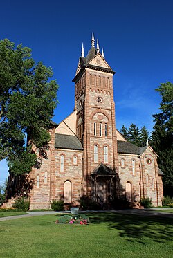
The Paris July 4 Celebration is the big event of the year, a tradition that brings people from miles around. Starting off with the KVSI fun run (8.6 miles) from the KVSI radio station in Montpelier, and ending in Paris where the City of Paris chuck wagon breakfast is held at the finish line. The Bear Lake Pageant is held at the Paris Tabernacle, followed by a parade that runs through the city. The event concludes with a youth rodeo at the Paris rodeo grounds.

Paleontology

The rocks west of Paris produce fossils of different organisms. A well-known paleontological site is recognized from Paris Canyon, from where a diverse fauna was described and named in 2017, the Paris biota.

Infrastructure

Notable people

Related Research Articles

<span class="mw-page-title-main">Eagle, Idaho</span> City in Idaho, United States

Eagle is a city in Ada County, Idaho 10 miles (16 km) northwest of Boise. The population was 30,346 at the 2020 census.

<span class="mw-page-title-main">Lava Hot Springs, Idaho</span> City in Bannock County, Idaho, United States

Lava Hot Springs is a city along the Portneuf River in eastern Bannock County, Idaho, United States. It is part of the Pocatello, Idaho metropolitan area. The population was 407 at the 2010 census, down from 521 in 2000. Located in the mountainous valley of the Portneuf River on the old route of the Oregon Trail and California Trail, the city has become a popular resort location, noted for its numerous hot springs amenable to bathing and a turbulent inner tube run through part of the town.

<span class="mw-page-title-main">McCammon, Idaho</span> City in Idaho, United States

McCammon is a city in Bannock County, Idaho, United States. It is part of the Pocatello, Idaho Metropolitan Statistical Area'. The population was 809 at the 2010 census. In 1892, McCammon became the junction point between the Oregon Short Line Railroad and Utah and Northern Railway, and city gained the nickname Junction City.

<span class="mw-page-title-main">Plummer, Idaho</span> City in Idaho, United States

Plummer is a city in Benewah County, Idaho, United States. The population was 1,044 at the 2010 census, up from 990 in 2000. It is the largest city within the Coeur d'Alene Reservation, and is accessed by U.S. Route 95, the state's primary north–south highway.

<span class="mw-page-title-main">Atomic City, Idaho</span> City in Bingham County, Idaho, United States

Atomic City is a city in Bingham County, Idaho, United States. The population was 41 at the 2020 census, up from 29 in 2010.

<span class="mw-page-title-main">Crouch, Idaho</span> City in Idaho, United States

Crouch is a city in Boise County, Idaho, United States. The population was 162 at the 2010 census. It is part of the Boise City–Nampa, Idaho Metropolitan Statistical Area. In 2018, it has multiple commercial businesses for tourists and residents: a small grocery mart, a hardware store, three restaurants, a bar, The Starlight Mountain Theater, and a community thrift store. At that time, the construction of the Banks/Lowman road 2512A, The "Wildlife Canyon Scenic Byway highway, transformed a small unpaved road unto a paved modern road between Crouch and Lowman. Now it is a fully modern paved roadway with informational and white water rafting pull outs which serves to transport tourists, rafters, commuters, and other traffic across the middle Idaho region.

<span class="mw-page-title-main">Priest River, Idaho</span> City in Idaho, United States

Priest River is a city in Bonner County, Idaho. The population was 1,751 at the 2010 census. Located in the Idaho Panhandle region of the state, the city is at the mouth of the Priest River on the Pend Oreille River.

<span class="mw-page-title-main">Swan Valley, Idaho</span> City in Idaho, United States

Swan Valley is a city in Bonneville County, Idaho, United States. It is part of the Idaho Falls, Idaho Metropolitan Statistical Area. The population was 204 at the 2010 census.

<span class="mw-page-title-main">Parma, Idaho</span> City in Canyon County, Idaho, United States

Parma is a city in Canyon County, Idaho, United States. The population was 1,983 at the 2010 census, up from 1,771 in 2000. It is the fourth largest city in the county and the largest in the rural western portion. It is part of the Boise City–Nampa, Idaho Metropolitan Statistical Area.

<span class="mw-page-title-main">Soda Springs, Idaho</span> City in the United States

Soda Springs is a city in Caribou County, Idaho, United States. Its population was 3,133 at the time of the 2020 census. The city has been the county seat of Caribou County since the county was organized in 1919. In the 1860s, Soda Springs served as the seat of Oneida County.

<span class="mw-page-title-main">Clayton, Idaho</span> City in Idaho, United States

Clayton is a city in Custer County, Idaho, United States. The population was 7 at the 2010 census, down from 27 in 2000. It is adjacent to the Salmon River.

<span class="mw-page-title-main">Mountain Home, Idaho</span> City in Idaho, United States

Mountain Home is the largest city and county seat of Elmore County, Idaho, United States. The population was 15,979 in the 2020 census. It is the principal city of the Mountain Home Micropolitan Statistical Area, which includes Elmore County.

<span class="mw-page-title-main">Dayton, Idaho</span> City in Idaho, United States

Dayton is a city in Franklin County, Idaho, United States. The population was 463 at the 2010 census. It is part of the Logan, Utah-Idaho Metropolitan Statistical Area.

<span class="mw-page-title-main">Drummond, Idaho</span> City in Idaho, United States

Drummond is a city in Fremont County, Idaho, United States. The population was 16 at the 2010 census. It is part of the Rexburg, Idaho Micropolitan Statistical Area.

<span class="mw-page-title-main">Hagerman, Idaho</span> City in Idaho, United States

Hagerman is a city in Gooding County, Idaho, United States. The population was 872 at the 2010 census, up from 656 in 2000. The area is noted for its fossil beds and the Thousand Springs of the Eastern Snake Plain Aquifer. Hagerman is home to a national fish hatchery, a university research station, and extensive aquaculture, assisted by an abundance of geothermal water for temperature regulation.

<span class="mw-page-title-main">Hamer, Idaho</span> City in Idaho, United States

Hamer is a city in Jefferson County, Idaho, United States. It is part of the Idaho Falls Metropolitan Statistical Area. The population was 48 at the 2010 census.

<span class="mw-page-title-main">Eden, Idaho</span> City in Idaho, United States

Eden is a city in Jerome County, Idaho, United States. The population was 405 at the 2010 census. It is part of the Twin Falls, Idaho Metropolitan Statistical Area.

<span class="mw-page-title-main">Jerome, Idaho</span> City in Idaho, United States

Jerome is a city in and county seat of Jerome County, Idaho, United States. The population was 10,890 at the 2010 census, up from 7,780 in 2000. The city is the county seat of Jerome County, and is part of the Twin Falls Micropolitan Statistical Area. It is the second largest city in Idaho's Magic Valley region, second only to Twin Falls which is located 10 miles (16 km) southeast. Jerome's economy is largely agrarian, with dairy farming being one of the main revenue sources for the local economy.

<span class="mw-page-title-main">Minidoka, Idaho</span> City in Idaho, United States

Minidoka is a city in Minidoka County, Idaho, United States. The population was 86 at the 2020 census, down from 112 in 2010. It is part of the Burley, Idaho Micropolitan Statistical Area.

<span class="mw-page-title-main">Cascade, Idaho</span> City in Idaho, United States

Cascade is a rural city in and the county seat of Valley County, Idaho, United States. The population was 939 at the 2010 census, down from 997 in 2000.

References

  1. "2019 U.S. Gazetteer Files". United States Census Bureau. Retrieved July 9, 2020.
  2. 1 2 "U.S. Census website". United States Census Bureau . Retrieved December 18, 2012.
  3. 1 2 "Population and Housing Unit Estimates". United States Census Bureau. May 24, 2020. Retrieved May 27, 2020.
  4. "2010 census: Idaho > Paris". Spokesman.com. Archived from the original on October 31, 2018. Retrieved December 3, 2012.
  5. "US Gazetteer files 2010". United States Census Bureau. Archived from the original on January 25, 2012. Retrieved December 18, 2012.
  6. "PRISM Climate Group at Oregon State University". Northwest Alliance for Computational Science & Engineering (NACSE), based at Oregon State University. Retrieved March 13, 2023.
  7. "Census of Population and Housing". Census.gov. Retrieved June 4, 2015.
  8. "U.S. Census website". United States Census Bureau . Retrieved January 31, 2008.

Commons-logo.svg Media related to Paris, Idaho at Wikimedia Commons