
Idaho is a landlocked state in the Pacific Northwest and Mountain West subregions of the Western United States. It borders Montana and Wyoming to the east, Nevada and Utah to the south, and Washington and Oregon to the west; the state shares a small portion of the Canada–United States border to the north with the Canadian province of British Columbia. Idaho's state capital and largest city is Boise. With an area of 83,569 square miles (216,440 km2), Idaho is the 14th-largest state by land area. The state has a population of approximately two million people; it ranks as the 13th-least populous and the seventh-least densely populated of the 50 U.S. states.

Rich County is a county in the U.S. state of Utah. As of the 2020 United States Census, the population was 2,510, making it the third-least populous county in Utah. Its county seat is Randolph, and the largest town is Garden City. The county was created in 1864. It was named for an early LDS apostle, Charles C. Rich.

Oneida County is a county located in the U.S. state of Idaho. As of the 2020 Census the county had a population of 4,564. The county seat and largest city is Malad City. Most of the county's population lives in Malad City and the surrounding Malad Valley.

Franklin County is a county located in the U.S. state of Idaho. As of the 2020 Census the county had a population of 14,194. The county seat and largest city is Preston. The county was established in 1913 and named after Franklin D. Richards, an Apostle of the Church of Jesus Christ of Latter-day Saints. It is the only Franklin County in the United States that is not named after Benjamin Franklin. Franklin County is part of the Logan, UT-ID Metropolitan Statistical Area.
Preston is a city in Franklin County, Idaho, United States. The population was 5,591 at the 2020 census, up from 5,204 at the 2010 census. The city is the county seat of Franklin County. It is part of the Logan, Utah-Idaho Metropolitan Statistical Area.

Logan is a city in Cache County, Utah, United States. The 2020 census recorded the population was 52,778. Logan is the county seat of Cache County and the principal city of the Logan metropolitan area, which includes Cache County and Franklin County, Idaho. The Logan metropolitan area contained 147,908 people as of the 2020 census. Logan is the location of the main campus of Utah State University.

U.S. Route 91 or U.S. Highway 91 is a 172.7-mile-long (277.9 km) north–south United States highway running from Brigham City, Utah, to Idaho Falls, Idaho, in the U.S. states of Idaho and Utah. Despite the "1" as the last digit in the number, US 91 is no longer a cross-country artery, as it has mostly been replaced by Interstate 15. The highway currently serves to connect the communities of the Cache Valley to I-15 and beyond. Prior to the mid-1970s, US 91 was an international commerce route from Long Beach, California, to the Canada–US border north of Sweetgrass, Montana. US 91 was routed on the main streets of most of the communities it served, including Las Vegas Boulevard in Las Vegas and State Street in Salt Lake City. From Los Angeles to Salt Lake, the route was built along the corridor of the Arrowhead Trail. A portion of the highway's former route in California is currently State Route 91.
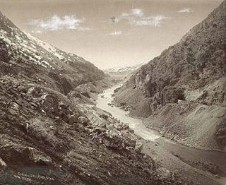
The Bear River is the largest tributary of the Great Salt Lake, draining a mountainous area and farming valleys northeast of the lake and southeast of the Snake River Plain. It flows through northeastern Utah, southwestern Wyoming, southeastern Idaho, and back into northern Utah, in the United States. Approximately 350 miles (560 km) long it is the longest river in North America that does not ultimately reach the sea.

Cache Valley(Shoshoni: Seuhubeogoi, “Willow Valley”) is a valley of northern Utah and southeast Idaho, United States, that includes the Logan metropolitan area. The valley was used by 19th century mountain men and was the site of the 1863 Bear River Massacre. The name, Cache Valley is often used synonymously to describe the Logan Metropolitan Area, one of the fastest growing metro areas in the US per capita — both in terms of economic GDP and population.
Whitney is a small unincorporated community in the Cache Valley of Franklin County, Idaho, United States. It is part of the Logan, Utah-Idaho Metropolitan Statistical Area.

William Bowker Preston was the fourth Presiding Bishop of the Church of Jesus Christ of Latter-day Saints between 1884 and 1907.

Holbrook is an unincorporated community along the Rock and Deep creeks in west central Oneida County, Idaho, United States.

Kelton is a ghost town, just north of the Great Salt Lake, in the Park Valley area of Box Elder County, Utah, United States. The town was inhabited during the period of 1869–1942. Once an important section station on the First transcontinental railroad, Kelton was dependent on the railroad throughout its history. The town suffered serious setbacks in the 1880s when its busy stagecoach route to Boise, Idaho was discontinued, and in the 1900s when the Lucin Cutoff left it off the main rail line. The strongest earthquake in Utah history caused severe damage in 1934, but Kelton ceased to exist only when the rails were completely removed during World War II.
The Logan Metropolitan Statistical Area, as defined by the United States Census Bureau, consists of two counties – one in Utah and one in Idaho, anchored by the city of Logan. As of the 2010 census, the MSA had a population of 125,442. As of the 2020 Census, the population had risen to 147,908, and further expanded to an estimated 155,362 as of 2022. The Logan metropolitan area is colloquially called Cache Valley, where most of the population resides.

The history of Idaho in the American Civil War is atypical, as the territory was far from the battlefields.

The following works deal with the cultural, political, economic, military, biographical and geologic history of pre-territorial Idaho, Idaho Territory and the State of Idaho.
The Sublett Range is a mountain range in Idaho (~94%) and Utah (~6%) in the United States, spanning Cassia, Oneida, and Power counties, Idaho and reaching into Box Elder County, Utah. The Phosphoria Formation reaches its greatest thickness beneath the mountains.

Altabank is a full-service bank headquartered in American Fork, Utah, United States, that was formerly known as People's Intermountain Bank. Prior to its acquisition by Glacier Bancorp, Altabank was owned by a publicly held holding company, People's Utah Bancorp, and was traded on the NASDAQ. It is the second-largest bank headquartered in Utah, and has 26 branches serving businesses and individuals in the area from Preston, Idaho to St. George, Utah. The current bank was formed from mergers of separate institutions including Bank of American Fork, Lewiston State Bank, and People's State Bank of American Fork These themselves had grown by opening new branches and by acquisitions, including, in the case of Bank of American Fork, by its acquisition of branches from Banner Bank.
Bench is an unincorporated community in Caribou County, in the U.S. state of Idaho.

