Fairfield, Idaho

Last updated

Fairfield, Idaho
Motto: 
"Gateway to Adventure"
Camas County Idaho Incorporated and Unincorporated areas Fairfield Highlighted 1626290.svg
Location of Fairfield in Camas County, Idaho.
Usa edcp location map.svg
Red pog.svg
Fairfield, Idaho
Location in the United States
Coordinates: 43°20′46″N114°47′28″W / 43.34611°N 114.79111°W / 43.34611; -114.79111
Country United States
State Idaho
County Camas
Area
[1]
  Total0.88 sq mi (2.27 km2)
  Land0.88 sq mi (2.27 km2)
  Water0.00 sq mi (0.00 km2)
Elevation
5,066 ft (1,544 m)
Population
 (2010) [2]
  Total416
  Estimate 
(2019) [3]
395
  Density450.91/sq mi (174.07/km2)
Time zone UTC-7 (Mountain (MST))
  Summer (DST) UTC-6 (MDT)
ZIP codes
83322, 83327
Area code 208
FIPS code 16-26290
GNIS feature ID0399870
Website cityoffairfieldidaho.com

Fairfield is the county seat of and the only village in Camas County, Idaho. The population was 410 at the time of 2010 census, nearly half of the rural county's population.

Contents

Geography

Fairfield is located at City 43°20′46″N114°47′28″W / 43.34611°N 114.79111°W / 43.34611; -114.79111 (43.346000, -114.791159), [4] at an elevation of 5,066 feet (1,544 m) above sea level.

According to the United States Census Bureau, the village has a total area of 0.88 square miles (2.28 km2), all of it land. [5]

Climate

According to the Köppen Climate Classification system, Fairfield has a warm-summer mediterranean continental climate, abbreviated "Dsb" on climate maps. The hottest temperature recorded in Fairfield was 101 °F (38.3 °C) on July 1214, 2002 and August 9, 2012, while the coldest temperature recorded was −42 °F (−41.1 °C) on January 19, 1984. [6]

Climate data for Fairfield, Idaho, 1991–2020 normals, extremes 1948–2020
MonthJanFebMarAprMayJunJulAugSepOctNovDecYear
Record high °F (°C)48
(9)
63
(17)
70
(21)
83
(28)
94
(34)
99
(37)
101
(38)
101
(38)
96
(36)
87
(31)
69
(21)
58
(14)
101
(38)
Mean maximum °F (°C)40.5
(4.7)
44.6
(7.0)
56.6
(13.7)
72.8
(22.7)
82.1
(27.8)
89.3
(31.8)
95.2
(35.1)
94.5
(34.7)
87.9
(31.1)
76.9
(24.9)
60.0
(15.6)
42.6
(5.9)
96.0
(35.6)
Average high °F (°C)27.3
(−2.6)
31.3
(−0.4)
40.7
(4.8)
53.8
(12.1)
64.5
(18.1)
73.0
(22.8)
84.0
(28.9)
82.8
(28.2)
73.8
(23.2)
59.0
(15.0)
41.7
(5.4)
28.0
(−2.2)
55.0
(12.8)
Daily mean °F (°C)18.3
(−7.6)
21.5
(−5.8)
30.7
(−0.7)
42.0
(5.6)
51.3
(10.7)
58.2
(14.6)
67.0
(19.4)
65.5
(18.6)
56.7
(13.7)
44.5
(6.9)
31.0
(−0.6)
19.0
(−7.2)
42.1
(5.6)
Average low °F (°C)9.2
(−12.7)
11.7
(−11.3)
20.6
(−6.3)
30.1
(−1.1)
38.1
(3.4)
43.3
(6.3)
50.1
(10.1)
48.3
(9.1)
39.5
(4.2)
30.1
(−1.1)
20.3
(−6.5)
10.0
(−12.2)
29.3
(−1.5)
Mean minimum °F (°C)−18.6
(−28.1)
−14.8
(−26.0)
0.5
(−17.5)
14.9
(−9.5)
23.1
(−4.9)
28.9
(−1.7)
35.9
(2.2)
32.9
(0.5)
23.6
(−4.7)
14.2
(−9.9)
−4.5
(−20.3)
−14.5
(−25.8)
−23.5
(−30.8)
Record low °F (°C)−42
(−41)
−38
(−39)
−24
(−31)
−3
(−19)
15
(−9)
19
(−7)
26
(−3)
23
(−5)
11
(−12)
−16
(−27)
−21
(−29)
−40
(−40)
−42
(−41)
Average precipitation inches (mm)2.11
(54)
1.50
(38)
1.61
(41)
1.11
(28)
1.60
(41)
0.85
(22)
0.38
(9.7)
0.35
(8.9)
0.70
(18)
0.97
(25)
1.39
(35)
1.98
(50)
14.55
(370.6)
Average snowfall inches (cm)11.6
(29)
6.9
(18)
2.4
(6.1)
1.1
(2.8)
0.1
(0.25)
0.0
(0.0)
0.0
(0.0)
0.0
(0.0)
0.0
(0.0)
0.4
(1.0)
5.7
(14)
14.6
(37)
39.2
(100)
Average precipitation days (≥ 0.01 in)4.84.94.84.75.43.62.31.62.23.35.84.848.2
Average snowy days (≥ 0.1 in)3.42.30.90.50.00.00.00.00.00.32.04.013.4
Source 1: NOAA [7]
Source 2: XMACIS2 (mean maxima/minima, snow/snow days, precip days 19812010) [6]

Demographics

Historical population
CensusPop.Note
1920 280
1930 3069.3%
1940 51167.0%
1950 502−1.8%
1960 474−5.6%
1970 336−29.1%
1980 40420.2%
1990 371−8.2%
2000 3956.5%
2010 4165.3%
2019 (est.)395 [3] −5.0%
U.S. Decennial Census [8]

2010 census

As of the census [2] of 2010, there were 416 people, 176 households, and 109 families residing in the village. The population density was 472.7 inhabitants per square mile (182.5/km2). There were 244 housing units at an average density of 277.3 per square mile (107.1/km2). The racial makeup of the city was 93.0% White, 1.0% Native American, 0.2% Asian, 1.4% from other races, and 4.3% from two or more races. Hispanic or Latino of any race were 6.3% of the population.

There were 176 households, of which 35.2% had children under the age of 18 living with them, 44.9% were married couples living together, 6.8% had a female householder with no husband present, 10.2% had a male householder with no wife present, and 38.1% were non-families. 31.8% of all households were made up of individuals, and 9.1% had someone living alone who was 65 years of age or older. The average household size was 2.36 and the average family size was 2.95.

The median age in the village was 35.1 years. 26.4% of residents were under the age of 18; 5.6% were between the ages of 18 and 24; 29.6% were from 25 to 44; 27.4% were from 45 to 64; and 11.1% were 65 years of age or older. The gender makeup of the village was 51.9% male and 48.1% female.

2000 census

Tractors in Fairfield, June 2007 Tractors by Josh Parrish.jpeg
Tractors in Fairfield, June 2007

As of the census [9] of 2000, there were 395 people, 162 households, and 115 families residing in the city. The population density was 1,214.3 inhabitants per square mile (468.8/km2). There were 211 housing units at an average density of 648.7 per square mile (250.5/km2). The racial makeup of the city was 97.97% White, 0.51% Native American, 0.25% from other races, and 1.27% from two or more races. Hispanic or Latino of any race were 6.08% of the population.

There were 162 households, out of which 33.3% had children under the age of 18 living with them, 60.5% were married couples living together, 6.8% had a female householder with no husband present, and 29.0% were non-families. 25.3% of all households were made up of individuals, and 11.1% had someone living alone who was 65 years of age or older. The average household size was 2.44 and the average family size was 2.92.

In the city, the population was spread out, with 25.6% under the age of 18, 7.3% from 18 to 24, 27.1% from 25 to 44, 27.6% from 45 to 64, and 12.4% who were 65 years of age or older. The median age was 39 years. For every 100 females, there were 96.5 males. For every 100 females age 18 and over, there were 94.7 males.

The median income for a household in the city was $31,167, and the median income for a family was $33,750. Males had a median income of $26,607 versus $16,667 for females. The per capita income for the city was $21,504. About 9.1% of families and 10.7% of the population were below the poverty line, including 6.7% of those under age 18 and 18.0% of those age 65 or over.

Transportation

Visitor caboose in Fairfield, June 2007 Caboose by Josh Parrish.jpeg
Visitor caboose in Fairfield, June 2007

Fairfield's main street is Soldier Road but is accessed by U.S. Route 20, a two-lane undivided highway connecting it to the west with Interstate 84 near Mountain Home, and to the east with State Highway 75 at Timmerman Junction in Blaine County. Four miles (6.4 km) east of Fairfield, State Highway 46 begins and proceeds south to Gooding.

Education

The public schools are operated by Camas County School District #121, headquartered in Fairfield. Camas County High School is the district's flagship school, located on Soldier Road in central Fairfield.

Recreation

The Soldier Mountains and Smoky Mountains of the Sawtooth National Forest (Fairfield Ranger District) are north of the village, offering many outdoor recreational opportunities. The Soldier Mountain ski area, established in 1948, is 12 miles (19 km) north of the village. The Snowkiting area, known around the world as one of the top destinations for this extreme sport, is 16 miles (26 km) west of the village. The Sun Valley ski resort is approximately 45 highway miles (70 km) northeast, up the Big Wood River Valley along State Highway 75, the Sawtooth Scenic Byway. [10] The western end of the Magic Reservoir is 10 miles (16 km) east of Fairfield, and the Silver Creek fly fishing stream is about 30 miles (50 km) east of the village.

Climate

Fairfield experiences a continental climate (Köppen Dsb) with cold, snowy winters and hot, dry summers.

Climate data for Fairfield Ranger Station
MonthJanFebMarAprMayJunJulAugSepOctNovDecYear
Record high °F (°C)48
(9)
63
(17)
70
(21)
83
(28)
94
(34)
99
(37)
101
(38)
100
(38)
96
(36)
87
(31)
69
(21)
55
(13)
101
(38)
Average high °F (°C)30.8
(−0.7)
36.2
(2.3)
44.5
(6.9)
56.9
(13.8)
67.1
(19.5)
76.1
(24.5)
85.3
(29.6)
84.9
(29.4)
75.6
(24.2)
63.4
(17.4)
43.3
(6.3)
31.5
(−0.3)
58.0
(14.4)
Average low °F (°C)5.9
(−14.5)
9.0
(−12.8)
18.6
(−7.4)
28.5
(−1.9)
35.9
(2.2)
41.9
(5.5)
47.4
(8.6)
45.5
(7.5)
36.5
(2.5)
27.5
(−2.5)
18.0
(−7.8)
7.2
(−13.8)
26.8
(−2.9)
Record low °F (°C)−42
(−41)
−38
(−39)
−24
(−31)
−3
(−19)
15
(−9)
19
(−7)
26
(−3)
23
(−5)
11
(−12)
−8
(−22)
−21
(−29)
−40
(−40)
−42
(−41)
Average precipitation inches (mm)2.22
(56)
1.71
(43)
1.45
(37)
1.05
(27)
1.33
(34)
0.83
(21)
0.60
(15)
0.42
(11)
0.69
(18)
0.82
(21)
1.77
(45)
1.98
(50)
14.87
(378)
Source 1: NOAA (normals, 1971–2000) [11]
Source 2: The Weather Channel (Records) [12]

The village was featured in a season two episode of The X-Files titled "Fearful Symmetry", in which an investigation at a fictitious zoo takes place. While the episode is set in Fairfield, it was, like many in the series, filmed in British Columbia, Canada.

See also

Related Research Articles

<span class="mw-page-title-main">Lincoln County, Idaho</span> County in Idaho, United States

Lincoln County is a county located in the U.S. state of Idaho. As of the 2020 census, the population was 5,127. The county seat and largest city is Shoshone. The county is named after President Abraham Lincoln. The Idaho Territory was created in 1863, during the Lincoln Administration of 1861–65.

<span class="mw-page-title-main">Jefferson County, Idaho</span> County in Idaho, United States

Jefferson County is a county located in the U.S. state of Idaho. As of the 2020 Census, the county's population was 30,891. The county seat and largest city is Rigby. The county was established in 1913 and named after Thomas Jefferson, the third U.S. President. Jefferson County is part of the Idaho Falls, ID Metropolitan Statistical Area.

<span class="mw-page-title-main">Elmore County, Idaho</span> County in Idaho, United States

Elmore County is a county in the U.S. state of Idaho. As of the 2020 census, the population was 28,666. The largest city and county seat is Mountain Home.

<span class="mw-page-title-main">Custer County, Idaho</span> County in Idaho, United States

Custer County is a rural mountain county in the center of the U.S. state of Idaho. As of the 2020 census, the population was 4,275. The county seat is Challis. Established in 1881, the county was named for the General Custer Mine, where gold was discovered five years earlier. Custer County relies on ranching, mining, and tourism as its main resources.

<span class="mw-page-title-main">Camas County, Idaho</span> County in Idaho, United States

Camas County is a county in the southern portion of the U.S. state of Idaho. The county seat and largest city is Fairfield. The county was established 106 years ago in 1917 by the Idaho Legislature with a partition of Blaine County on February 6. It is named for the camas root, or Camassia, a lily-like plant with an edible bulb found in the region, that Native Americans and settlers used as a food source. As of the 2020 census, the population was 1,077, making it the second-least populous county in the state, after Clark County.

<span class="mw-page-title-main">Boise County, Idaho</span> County in Idaho, United States

Boise County is a rural mountain county in the U.S. state of Idaho. As of the 2020 United States Census, the population was 7,610. The county seat is historic Idaho City, which is connected through a series of paved and unpaved roads to Lowman, Centerville, Placerville, Pioneerville, Star Ranch, Crouch, Garden Valley, and Horseshoe Bend.

<span class="mw-page-title-main">Blaine County, Idaho</span> County in Idaho, United States

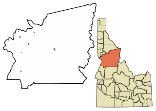
Blaine County is a county in the U.S. state of Idaho. As of the 2020 United States Census, the population was 24,272. The county seat and largest city is Hailey. It is also home to the Sun Valley ski resort, adjacent to Ketchum.

<span class="mw-page-title-main">McNeil, Arkansas</span> Town in Arkansas, United States

McNeil is a town in Columbia County, Arkansas, United States. The population was 516 at the 2010 census, down from 662 in 2000. The community was named after William B. McNeil, founder of the College Hill Academy.

<span class="mw-page-title-main">Bellevue, Idaho</span> City in Idaho, United States

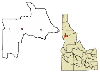
Bellevue is a city in Blaine County in the central part of the U.S. state of Idaho. The population was 2,287 at the 2010 census, up from 1,876 in 2000.

<span class="mw-page-title-main">Orofino, Idaho</span> City in Idaho, United States

Orofino is a city in and the county seat of Clearwater County, Idaho, United States, along Orofino Creek and the north bank of the Clearwater River. It is the major city within the Nez Perce Indian Reservation. The population was 3,142 at the time of the 2010 census.

<span class="mw-page-title-main">Stanley, Idaho</span> Town in Idaho, United States

Stanley is a town in the Sawtooth Valley in Custer County, Idaho, United States. The population was 116 at the 2020 census; up from 63 in 2010. The center of population of Idaho in 2000 was located in Stanley.

<span class="mw-page-title-main">Mountain Home, Idaho</span> City in Idaho, United States

Mountain Home is the largest city and county seat of Elmore County, Idaho, United States. The population was 15,979 in the 2020 census. Mountain Home is the principal city of the Mountain Home, Idaho Micropolitan Statistical Area, which includes Elmore County.

<span class="mw-page-title-main">Cottonwood, Idaho</span> City in the United States

Cottonwood is a city in Idaho County, Idaho. On the Camas Prairie in north central Idaho, the population was 900 at the 2010 census, down from 944 in 2000. It is just west of U.S. Route 95, between Grangeville and Lewiston.

<span class="mw-page-title-main">Ferdinand, Idaho</span> City in Idaho, United States

Ferdinand is a city in Idaho County, Idaho, United States. The population was 159 at the 2010 census, up from 145 in 2000. At the southern end of the Nez Perce Indian Reservation, it was founded by F.M. Bieker shortly after the reservation was opened for settlement in 1895. It was named after Ferdinand, Indiana, where his mother's family had lived.

<span class="mw-page-title-main">Grangeville, Idaho</span> City in Idaho, United States

Grangeville is the largest city in and the county seat of Idaho County, Idaho, United States, in the north central part of the state. Its population was 3,141 at the 2010 census, down from 3,228 in 2000.

<span class="mw-page-title-main">Kooskia, Idaho</span> City in Idaho, United States

Kooskia is a city in Idaho County, Idaho, United States. It is at the confluence of the South and Middle forks of the Clearwater River, combining to become the main river. The population was 607 at the 2010 census, down from 675 in 2000.

<span class="mw-page-title-main">Craigmont, Idaho</span> City in Idaho, United States

Craigmont is a city in the northwest United States in Lewis County, Idaho. Located on the Camas Prairie in north central Idaho, it is within the Nez Perce Indian Reservation. The population was 501 at the 2010 census, down from 556 in 2000.

<span class="mw-page-title-main">Nezperce, Idaho</span> City in Idaho, United States

Nezperce is a city in and the county seat of Lewis County, Idaho, United States. The population was 466 at the 2010 census, down from 523 in 2000. Nezperce is named for the local Nez Perce tribe of Native Americans. There is one school district, Nezperce School District #302.

<span class="mw-page-title-main">Shoshone, Idaho</span> City in Idaho, United States

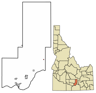
Shoshone is the county seat and largest city of Lincoln County, Idaho, United States. The population was 1,461 at the 2010 census. In contrast to the Shoshone Native American tribe for which it is named, the city's name is correctly pronounced "Show-shown", with a silent "e".

<span class="mw-page-title-main">Fairfield, Texas</span> City in Texas, United States

Fairfield is a city in Freestone County, Texas, United States. The population was 2,850 at the 2020 census, down from 3,094 at the 2000 census. It is the county seat of Freestone County and was founded as such in 1851.

References

  1. "2019 U.S. Gazetteer Files". United States Census Bureau. Retrieved July 9, 2020.
  2. 1 2 "U.S. Census website". United States Census Bureau . Retrieved December 18, 2012.
  3. 1 2 "Population and Housing Unit Estimates". United States Census Bureau. May 24, 2020. Retrieved May 27, 2020.
  4. "US Gazetteer files: 2010, 2000, and 1990". United States Census Bureau. February 12, 2011. Retrieved April 23, 2011.
  5. "US Gazetteer files 2010". United States Census Bureau. Archived from the original on January 25, 2012. Retrieved December 18, 2012.
  6. 1 2 "xmACIS2". National Oceanic and Atmospheric Administration. Retrieved February 20, 2023.
  7. "U.S. Climate Normals Quick Access – Station: Fairfield RS, ID". National Oceanic and Atmospheric Administration. Retrieved February 20, 2023.
  8. "Census of Population and Housing". Census.gov. Retrieved June 4, 2015.
  9. "U.S. Census website". United States Census Bureau . Retrieved January 31, 2008.
  10. Idaho Byways - Sawtooth Scenic Byway Archived 2009-06-27 at the Wayback Machine
  11. "Climatography of the United States NO.81" (PDF). National Oceanic and Atmospheric Administration. Archived from the original (PDF) on July 16, 2014. Retrieved January 16, 2011.
  12. "Monthly Averages for Fairfield, ID". The Weather Channel . Retrieved January 16, 2011.