Sawtooth National Forest is a National Forest that covers 2,110,408 acres in the U.S. states of Idaho and Utah. Managed by the U.S. Forest Service in the U.S. Department of Agriculture, it was originally named the Sawtooth Forest Reserve in a proclamation issued by President Theodore Roosevelt on May 29, 1905. On August 22, 1972, a portion of the forest was designated as the Sawtooth National Recreation Area (SNRA), which includes the Sawtooth, Cecil D. Andrus–White Clouds, and Hemingway–Boulders wilderness areas. The forest is managed as four units: the SNRA and the Fairfield, Ketchum, and Minidoka Ranger Districts.

The Sawtooth National Recreation Area (SNRA) is a national recreation area in central Idaho, United States that is managed as part of Sawtooth National Forest. The recreation area, established on August 22, 1972, is managed by the U.S. Forest Service, and includes the Sawtooth, Hemingway–Boulders, and Cecil D. Andrus–White Clouds wilderness areas. Activities within the 730,864-acre (2,957.70 km2) recreation area include hiking, backpacking, White water rafting, camping, rock climbing, kayaking, mountain biking, fishing, and hunting.

The Sawtooth Range is a mountain range of the Rocky Mountains in central Idaho, United States, reaching a maximum elevation of 10,751 feet (3,277 m) at the summit of Thompson Peak. It encompasses an area of 678 square miles (1,756 km2) spanning parts of Custer, Boise, Blaine, and Elmore counties, and is bordered to the east by the Sawtooth Valley. Much of the mountain range is within the Sawtooth Wilderness, part of the Sawtooth National Recreation Area and Sawtooth National Forest.

The Big Wood River is a 137-mile-long (220 km) river in central Idaho, United States, that is a tributary of the Malad River.

The White Cloud Mountains are part of the Rocky Mountains of the western United States, located in central Idaho, southeast of Stanley in Custer County. The range is located within the Sawtooth National Recreation Area (SNRA) and partially within the Cecil D. Andrus–White Clouds Wilderness.

Castle Peak is a mountain in the western United States, the highest peak in the White Cloud Mountains of central Idaho and the Idaho Batholith. Located in Custer County, it is the 25th highest peak in the state, and the ninth most prominent.
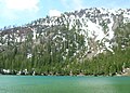
The Trail Creek Lakes are a series of five small alpine glacial lakes in Boise County, Idaho, United States, located in the Sawtooth Mountains in the Sawtooth National Recreation Area. The lakes are on Trail Creek, which is a tributary of the South Fork Payette River. The lakes can be accessed from Sawtooth National Forest trail 453.
The Trailer Lakes are a series of three small alpine glacial lakes in Boise County, Idaho, United States, located in the Sawtooth Mountains in the Sawtooth National Recreation Area. The Trailer Lakes are in the Trail Creek watershed, which is a tributary of the South Fork Payette River. The lakes are most easily accessed from Sawtooth National Forest trail 453.
The McGown Lakes are a series of seven small alpine glacial lakes in Custer County, Idaho, United States, located in the Sawtooth Mountains in the Sawtooth National Recreation Area. The lakes are in the Stanley Lake Creek watershed and can be accessed from Sawtooth National Forest trail 640.
The Stevens Lakes are a chain of small alpine lakes in Custer County, Idaho, United States, located in the Sawtooth Mountains in the Sawtooth National Recreation Area. There are no trails leading to the lakes.

The Bench Lakes are a chain of five small alpine glacial lakes in Custer County, Idaho, United States, located in the Sawtooth Mountains in the Sawtooth National Recreation Area. A cutoff from Sawtooth National Forest trail 101 along Redfish Lake leads to the Bench Lakes. The lakes are drained by an unnamed stream that flows into Redfish Lake, Redfish Lake Creek, and eventually the Salmon River.
The Upper Redfish Lakes are a chain of small alpine glacial lakes in Custer County, Idaho, United States, located in the Sawtooth Mountains in the Sawtooth National Recreation Area. The lakes are drained by an unnamed creek that is a tributary of Redfish Lake Creek, which flows into the Salmon River. There are no trails that lead to the lakes, although they are most easily accessed from Sawtooth National Forest trail 154 along Redfish Lake Creek.
The Saddleback Lakes are a chain of small alpine glacial lakes in Custer County, Idaho, United States, located in the Sawtooth Mountains in the Sawtooth National Recreation Area. The lakes are drained by an unnamed tributary of Redfish Lake Creek, which flows into the Salmon River. There are no trails that lead to the lakes, although they are most easily accessed from Sawtooth National Forest trail 154.

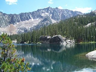
The Twin Lakes are two adjacent alpine Glacial lakes separated by a narrow strip of land less than 100 ft (30 m) wide in Blaine County, Idaho, United States, located in the Sawtooth Mountains in the Sawtooth National Recreation Area. The lakes eventually flow into the Salmon River. Sawtooth National Forest trail 092 leads to the twin lakes.
The Feather Lakes are a chain of four small alpine glacial lakes in Boise County, Idaho, United States, located in the Sawtooth Mountains in the Sawtooth National Recreation Area. The lakes are located on Goat Creek which is a tributary of the South Fork Payette River. There are no trails leading to the lakes or the Goat Creek drainage.
The Boulder Mountains are part of the Rocky Mountains in the western United States. Located in central Idaho, they stretch from a few miles north of Ketchum to north to near Challis, and part of the range is within the Sawtooth National Recreation Area (SNRA) and partially within the Hemingway–Boulders Wilderness. The highest point in the range is Ryan Peak, at 11,714 feet (3,570 m) above sea level.

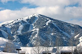
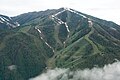
The Soldier Mountains are a mountain range in the U.S. state of Idaho, spanning northern Camas and eastern Elmore counties. The highest point in the range is Smoky Dome at 10,095 feet (3,077 m), and the range is bounded on the west and north by the South Fork Boise River. The mountains are located within Sawtooth National Forest north of Fairfield, Idaho. The Soldier Mountain Ski Area is located within the range to the east of Smoky Dome.

Chamberlain Basin is a drainage basin that contains a chain of ten alpine and glacial Paternoster lakes in Custer County, Idaho, United States, located in the White Cloud Mountains in the Sawtooth National Recreation Area. Lakes are located on the upper portion of Chamberlain Creek in the Germania Creek watershed, a tributary of the East Fork Salmon River. Castle Peak, the highest summit in the White Cloud Mountains, rises to the east and north of Chamberlain Basin. Sawtooth National Forest trail 047 crosses the basin, although most people begin their trips at the Fourth of July Creek trailhead. Individual lakes do not have official names and are listed from lowest to highest elevation.
The Champion Lakes are a chain of seven alpine and glacial Paternoster lakes in Custer County, Idaho, United States, located in the White Cloud Mountains in the Sawtooth National Recreation Area. The lakes are located on the upper portion of the Champion Creek watershed, a tributary of the Salmon River. The lakes have not been individually named, and lakes 5 and 6 are often dry. Sawtooth National Forest trail 105 leads to the lakes. In 2005 the Valley Road Forest Fire burned part of the Champion Lakes Basin.

The Albion Mountains are a mountain range in the U.S. states of Idaho (~99%) and Utah (~1%), spanning Cassia County, Idaho and barely reaching into Box Elder County, Utah. The highest point in the range is Cache Peak at 10,339 feet (3,151 m), and the range is a part of the Basin and Range Province. Most of the mountains are part of the Albion Division of the Minidoka Ranger District of Sawtooth National Forest.