
The Sawtooth Range is a mountain range of the Rocky Mountains in central Idaho, United States, reaching a maximum elevation of 10,751 feet (3,277 m) at the summit of Thompson Peak. It encompasses an area of 678 square miles (1,756 km2) spanning parts of Custer, Boise, Blaine, and Elmore counties, and is bordered to the east by the Sawtooth Valley. Much of the mountain range is within the Sawtooth Wilderness, part of the Sawtooth National Recreation Area and Sawtooth National Forest.

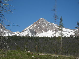
Thompson Peak is the highest peak in the Sawtooth Range of Idaho. Its 10,751 ft (3,277 m) summit is located within Custer County, although some of the lower portion of the mountain is in Boise County. Thompson Peak is also located within the Sawtooth Wilderness portion of the Sawtooth National Recreation Area, a unit of Sawtooth National Forest. The town of Stanley, Idaho is about 6 miles (9.7 km) northeast of Thompson Peak.

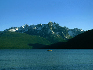
Stanley Lake is an alpine lake in the western United States, located in Custer County, Idaho, at the base of the Sawtooth Mountains in the Sawtooth National Recreation Area.
Williams Peak, at 10,636 feet (3,242 m) high is the 6th highest peak in the Sawtooth Mountains of Idaho and is located within the Sawtooth Wilderness portion of the Sawtooth National Recreation Area. The peak lies 0.75 mi (1,210 m) north-northeast of Thompson Peak, the highest peak in the range.

Alpine Lake is an alpine lake in Custer County, Idaho, United States, located high in the Sawtooth Mountains in the Sawtooth National Recreation Area. The lake is approximately 11.4 miles (18.3 km) southwest of Stanley.

The Albion Mountains are a mountain range in the U.S. states of Idaho (~99%) and Utah (~1%), spanning Cassia County, Idaho and barely reaching into Box Elder County, Utah. The highest point in the range is Cache Peak at 10,339 feet (3,151 m), and the range is a part of the Basin and Range Province. Most of the mountains are part of the Albion Division of the Minidoka Ranger District of Sawtooth National Forest.
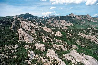
Cache Peak, at 10,339 feet (3,151 m) above sea level, is the highest peak in the Albion Mountains of Cassia County in Southern Idaho. Cache Peak is located in the central part of the range southeast of Oakley and north of Almo in the Albion Division of the Minidoka Ranger District of Sawtooth National Forest.
The Independence Lakes are a chain of four alpine glacial lakes in Cassia County, Idaho, United States, located in the Albion Mountains in Sawtooth National Forest. The lakes are located in the basin north of Cache Peak and east of Mount Independence in the upper portion of the Green Creek watershed. The lakes have not been individually named, and trail 805 leads to the lakes. The closest trailhead is the Independence Lakes trailhead at the end of forest road 728.
Mount Independence is the second highest peak in the Albion Mountains of Idaho. The peak is located in Sawtooth National Forest and Cassia County. It is located about 1 mi (1.6 km) northwest of Cache Peak. The Independence Lakes are located in the basin to the east of the peak. Mount Independence supports one of the three populations of Cymopterus davisii, a plant that is endemic to the Albion Mountains. The Mount Independence population is considered a single population with Cache Peak. Mount Independence is 9,950 feet (3,030 m) above sea level.
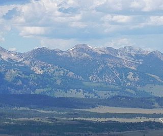
Paradise Peak, at 9,798 feet (2,986 m) above sea level is a peak in the Smoky Mountains of Idaho. The peak is located in Sawtooth National Forest in Camas County. It is located in the watersheds of Paradise and Emma creeks and the South Fork of the Boise River. It is about 4 mi (6.4 km) northwest of Skillern Peak, 0.35 mi (0.56 km) northwest of Paradise Lake, and 1.2 mi (1.9 km) west of Snowslide Lake. No roads or trails go to the summit.

Braxon Peak, at 10,353 feet (3,156 m) above sea level is a peak in the Sawtooth Range of Idaho. The peak is located in the Sawtooth Wilderness of Sawtooth National Recreation Area on the border of Boise and Custer counties. The peak is located 1.36 mi (2.19 km) south of Mount Cramer, its line parent. It is also about 1.2 mi (1.9 km) south-southwest of Mount Heyburn. Braxon Lake is just southwest of the peak.

Packrat Peak, at 10,240 feet (3,120 m) above sea level is a peak in the Sawtooth Range of Idaho in the United States. The peak is located in the Sawtooth Wilderness of Sawtooth National Recreation Area on the border of Boise and Custer counties. The peak is located 2.38 mi (3.83 km) north of Elk Peak, its line parent. Warbonnet and Little Warbonnet lakes are in the basin north of the peak.

Mount Regan, rises 10,190 feet (3,110 m) above sea level, and is a peak in the Sawtooth Range of Idaho. The peak is located in the Sawtooth Wilderness of Sawtooth National Recreation Area on the border of Boise and Custer counties. The peak is located 1.9 mi (3.1 km) west of Merritt Peak, its line parent. The peak is named after Timothy Regan, a pioneer who lived in Silver City, and then Boise. Mount Regan is located at the southern end of Sawtooth Lake. The Trailer Lakes and Regan Lake are located northwest of the peak, and the Trail Creek Lakes are west of the peak.
The Grand Mogul, at 9,733 feet (2,967 m) above sea level is a peak in the Sawtooth Range of Idaho. The peak is located in the Sawtooth Wilderness of Sawtooth National Recreation Area in Custer County. The peak is located 0.95 mi (1.53 km) north-northwest of Little Decker, its line parent. The Grand Mogul is at the southwest end of Redfish Lake and 1.7 mi (2.7 km) southeast of Mount Heyburn.

El Capitan is a mountain in the western United States, in the Sawtooth Range of central Idaho. Located in the Sawtooth Wilderness of Sawtooth National Recreation Area in Blaine County, it is 1.2 miles (1.9 km) south-southeast of Peak 10,052, its line parent.
McDonald Peak, at 10,068 feet (3,069 m) above sea level is a peak in the Sawtooth Range of Idaho. The peak is located in the Sawtooth Wilderness of Sawtooth National Recreation Area in Blaine County. The peak is located 1.93 mi (3.11 km) southeast of Parks Peak, its line parent. It is southwest of Pettit Lake.
Parks Peak, at 10,280 feet (3,130 m) above sea level is a peak in the Sawtooth Range of Idaho. The peak is located in the Sawtooth Wilderness of Sawtooth National Recreation Area on the border of Blaine and Custer counties. The peak is located 2.78 mi (4.47 km) northeast of Snowyside Peak, its line parent, and 1.9 mi (3.1 km) northwest of McDonald Peak. Farley Lake is north of the peak and Bowknot and Toxaway lakes are west of the peak.
McGowan Peak is a peak in the Sawtooth Range of Idaho that is 9,860 feet (3,010 m) above sea level. The peak is located in the Sawtooth Wilderness of Sawtooth National Recreation Area in Custer County. The peak is located 3.25 mi (5.23 km) north-northwest of Alpine Peak, its line parent. McGowan Peak rises above the southwest end of Stanley Lake.

D. O. Lee Peak, also known as Lee Peak, at 11,347 feet (3,459 m) above sea level, is the third-highest peak in the White Cloud Mountains of the U.S. state of Idaho. It is one of the White Cloud Peaks and the 56th-highest peak in Idaho. It was named after Challis native David Oliver Lee (1934–1982), the first United States Forest Service ranger to be assigned to the Sawtooth Wilderness.

Patterson Peak at 10,872 feet (3,314 m) above sea level is a peak in the White Cloud Mountains of Idaho. The peak is located in Sawtooth National Recreation Area in Custer County 2.70 mi (4.35 km) west of Castle Peak, its line parent. Patterson Peak is about 1.5 mi (2.4 km) northeast of Fourth of July Peak, and it rises to the east of Fourth of July Lake. Glacier, Rock, Emerald, and Cornice lakes are in the basin to the northeast of the peak.

